Skip to content

Sharing the Fascinating Ice Age Floods Story Since 1995

  • Explore!
    • Intro to the Ice Age Floods
    • Ice Age Floods National Geologic Trail
      • NPS Teacher’s Curriclum Guide
    • Places to Go! and Things to Do!
      • Montana
      • Idaho
      • Washington
      • Oregon
    • Ice Age Floods Interactive Map
    • Explore Ice Age Floods Videos
  • News&Events
    • IAFI News
    • IAFI Events
      • Activities
      • Presentations
      • Other Events
    • IAFI Archives
      • More News From Our Archives
  • Join/Renew/Donate
    • About IAFI
      • IAFI Board of Directors
    • Become a New/Renewing Member!
    • Donate to IAFI
  • Chapters
    • All Chapters Home Page
      • About IAFI
      • Explore the Ice Age Floods with IAFI Chapter Brochures
    • Cheney-Spokane
    • Coeur du Deluge
    • Columbia River Gorge
    • Ellensburg
    • Glacial Lake Missoula
    • Lake Lewis
    • Lower Columbia
    • Lower Grand Coulee
    • Palouse Falls
    • Puget Lobe
    • Wenatchee Valley Erratics
  • Education
    • K-12 Ice Age Floods Curriculum: Floods in the Classroom
    • IAFI Education Grants
      • Introducing IAFI’s K-12 Education Grant Program
      • Grants to Inspire New Generations
  • Store
    • IAFI Store Home Page
    • Books
    • Prints & Posters
    • Maps
    • Videos & DVDs
    • Apparel
    • General Merchandise
    • Cart
    • Checkout
  • Resources
    • Intro to the Ice Age Floods
    • Ice Age Floods Interactive Map
      • Explore Historical Field Research with Google Maps
    • IAFI Pleistocene Post Newsletters
    • Field Trips & Field Guides
      • Field Guides Collection
      • WSU Field Trips Last – Reidel
    • Ice Age Floods Videos
    • Science Corner
      • Science Corner Page
      • Science Corner Articles
    • General Resources
      • Educator Resources
      • Online Resources & Maps
      • Technical Articles
      • Geology Terms
    • IAFI Documents
      • IAFI Chapter Brochures
      • IAFI Board Minutes
      • IAFI Legal Records
      • IAFI Website Articles
  • Contact
    • Contact IAFI
    • IAFI Board of Directors
  • Explore!
    • Intro to the Ice Age Floods
    • Ice Age Floods National Geologic Trail
      • NPS Teacher’s Curriclum Guide
    • Places to Go! and Things to Do!
      • Montana
      • Idaho
      • Washington
      • Oregon
    • Ice Age Floods Interactive Map
    • Explore Ice Age Floods Videos
  • News&Events
    • IAFI News
    • IAFI Events
      • Activities
      • Presentations
      • Other Events
    • IAFI Archives
      • More News From Our Archives
  • Join/Renew/Donate
    • About IAFI
      • IAFI Board of Directors
    • Become a New/Renewing Member!
    • Donate to IAFI
  • Chapters
    • All Chapters Home Page
      • About IAFI
      • Explore the Ice Age Floods with IAFI Chapter Brochures
    • Cheney-Spokane
    • Coeur du Deluge
    • Columbia River Gorge
    • Ellensburg
    • Glacial Lake Missoula
    • Lake Lewis
    • Lower Columbia
    • Lower Grand Coulee
    • Palouse Falls
    • Puget Lobe
    • Wenatchee Valley Erratics
  • Education
    • K-12 Ice Age Floods Curriculum: Floods in the Classroom
    • IAFI Education Grants
      • Introducing IAFI’s K-12 Education Grant Program
      • Grants to Inspire New Generations
  • Store
    • IAFI Store Home Page
    • Books
    • Prints & Posters
    • Maps
    • Videos & DVDs
    • Apparel
    • General Merchandise
    • Cart
    • Checkout
  • Resources
    • Intro to the Ice Age Floods
    • Ice Age Floods Interactive Map
      • Explore Historical Field Research with Google Maps
    • IAFI Pleistocene Post Newsletters
    • Field Trips & Field Guides
      • Field Guides Collection
      • WSU Field Trips Last – Reidel
    • Ice Age Floods Videos
    • Science Corner
      • Science Corner Page
      • Science Corner Articles
    • General Resources
      • Educator Resources
      • Online Resources & Maps
      • Technical Articles
      • Geology Terms
    • IAFI Documents
      • IAFI Chapter Brochures
      • IAFI Board Minutes
      • IAFI Legal Records
      • IAFI Website Articles
  • Contact
    • Contact IAFI
    • IAFI Board of Directors
4 events found.

Presentation

  1. Events
  2. Presentation

Events

Events Search and Views Navigation

Event Views Navigation

  • List
  • Month
  • Day
Today
  • July 2026

  • Tue 21

    Spirit Lake Library Lecture II: The Ice Age Missoula floods and the Spirit Lake giant current dune field

    July 21 @ 1:00 pm - 2:30 pm PDT
    Spirit Lake Library 32575 N 5th Ave, Spirit Lake, ID

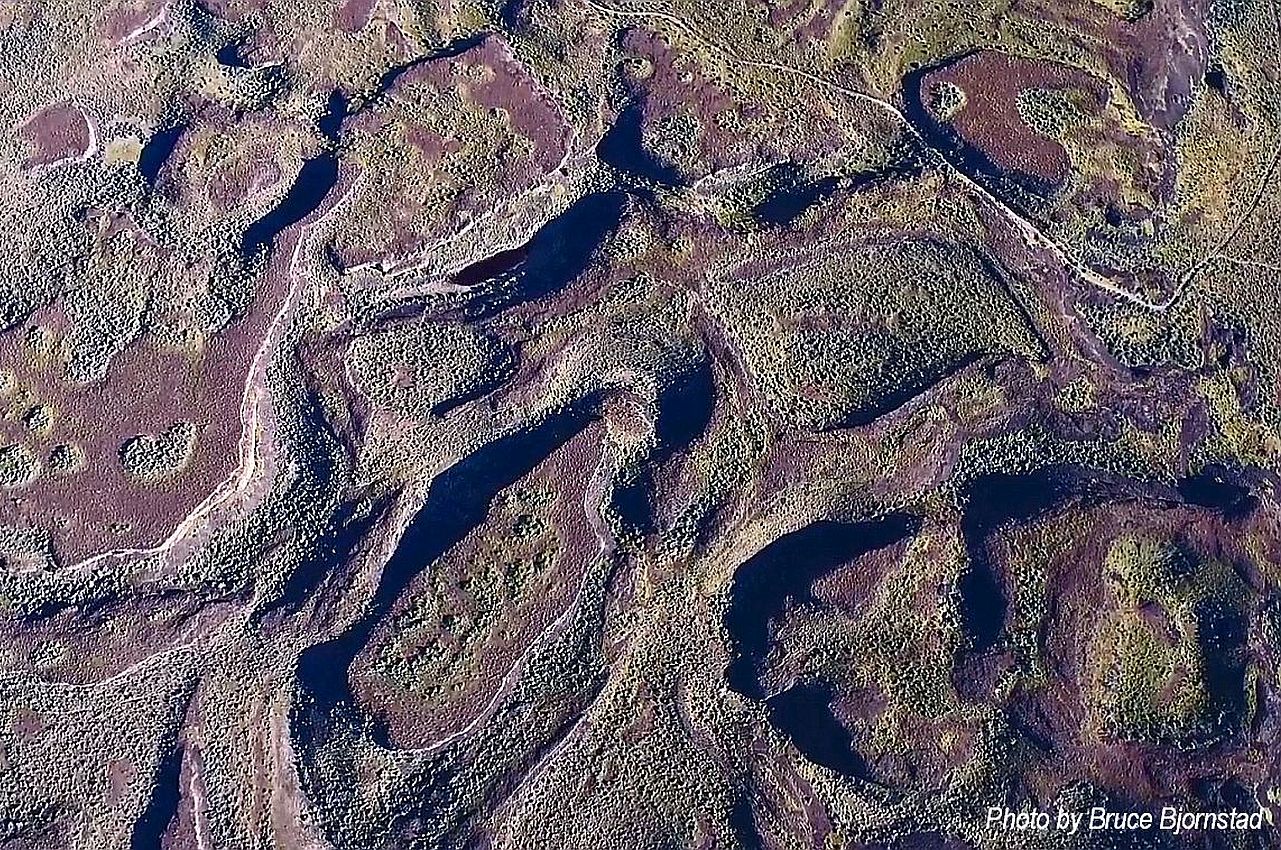
    (This will be the same presentation as June 27.) Giant Current Dunes or MegaRipple Marks – One of the most important pieces of evidence for catastrophic flooding was the “giant current dunes.” These large-scale bedforms appeared as patterns of parallel ridges and swales on many aerial photographs in the flood channels in the scabland of Washington, but had escaped recognition from the ground because of their size.  Giant Current Dunes are visible west of Clark Fork near Castle Rock; however, the most prominent and visible Giant Current Dunes are located several miles east of Spirit Lake along Hwy 54 where the highway cuts through the dunes showing their undulating profile. The location of many of the telephone poles on the crest of these dunes accentuates these landforms. The dunes form transverse to the current direction, and form cusps that are convex upstream, with arms that point downstream. Furthermore, the size of the cusps appears to decrease in the direction of lower velocity. Internally, the dunes consist of gravel and pebble foresets. Giant current dunes exhibit an asymmetrical profile with the downstream (lee) slope steeper than the upstream slope. Crests range from 20 to 200m apart and heights range from 1 to 15m (Baker and Nummedal, 1978) and are among the largest measured throughout the Floods area. The Spirit Lake current dunes can also be easily recognized from the air by their characteristic pattern, accentuated by vegetation. This dune field is immediately in the path of the breakout from Lake Pend Oreille, and experienced some of the highest energy flows. Presented by Dr. Linda McCollum, president of the Ice Age Floods Institute (IAFI), Cheney-Spokane Chapter No registration required. Call Librarian Nicole Ferris with any questions at 208-623-5353. PDF Resource Materials Waitt, R.B. 2016 Megafloods and Clovis cache at Wenatchee, Washington Baker, V.R. 2023 J Harlen Bretz & the cataclysmic Late Pleistocene mega-flooding origin of the Channeled Scabland Romano, M. 2015 Reviewing the term uniformitarianism in modern Earth sciences Baker, V.R. Sept. 1995 Joseph Thomas Pardee and the Spokane Flood Controversy

  • September 2026

  • Sat 12

    Free ‘Night Sky Over Cottonwood Canyon’ Dark Skies Presentation and Night Telescope Viewing

    September 12 @ 7:00 pm - September 13 @ 12:00 pm PDT
    Cottonwood Canyon State Park OR-206 Highway, near Wasco, OR, United States

    Night Sky Over Cottonwood Canyon, a free presentation and night telescope viewing by Dark Skies leader and Gorge Chapter member Mike McKeag, will be held at Cottonwood Canyon, State Park (near Wasco, Oregon) on Saturday, Sept. 12, beginning at 7:00 PM. The evening will begin with a short presentation by park ranger, Stan Petersen, on light pollution, followed by Mike's presentation linking objects in that night's sky with historical and geological events. Mike will describe the stages of twilight, and then some of the night sky objects' distances form us, when the light we observe that night started on its way to us, and their availability for observation as the sky darkens. He'll then relate that time to events in human or geological history, such as the geological history exposed in the canyon walls. For more distant objects the events are geological. The last event is emplacement of the Grand Ronde basalts exposed in the canyon walls of Cottonwood Canyon (~16 mya), corresponding to the departure time of light from the spiral galaxy M94, 16 M light years distant. The presentations will end as we are entering nautical twilight and brighter stars are beginning to appear. Rose City Astronomers volunteers will be there with their telescopes, sharing views of these and other objects available to view that night, as well as pointing out several of the constellations that will be visible. This event is free and open to the public, with attendees of all ages welcome. Pre-registration, however is required and free overnight tent camping will be available in the Day Use Area for this event. Cottonwood Canyon State Park is a popular, certified International Dark Sky Park with several hiking paths, interesting geology, birding and other flora and fauna. The park straddles the lower John Day River so there's good fishing and a boat launch access at J.S. Burres just across the river. You can take advantage of this opportunity to explore an exceptional area. Note: Cottonwood Canyon State Park is remote. There is no food, fuel or other services nearby. Please plan ahead thoughtfully for your trip. Star Party may be cancelled if bad weather or lack of volunteers with telescopes are not available.

  • Thu 17

    Landforms of the Channeled Scablands

    September 17 @ 6:00 pm - 7:00 pm PDT
    Connell Library 118 N. Columbia, Connell, Washington

    Take a tour of the channeled scablands identifying the diversity of  landforms in our area answering the question— ‘Where do we find them and how did they form?” The viewer will leave with a greater appreciation of our unique geomorphology and be able to identify the landforms as they travel through the scablands.  

  • Wed 23

    The Bretz Field Notes – New Discoveries and Insights

    September 23 @ 4:30 pm - 5:30 pm PDT
    Whitman County Library 102 South Main St., Colfax, WA, United States

    Glenn Cruickshank, Vice President of the Cheney-Spokane Chapter will give this interesting presentation. Glenn and CWU professor Nick Zentner read over 1,000 field notes of J Harlen Bretz. With these notes, they geolocated over 1,660 sites. This gives us an understanding of the sites Bretz visited and his thought process of interpreting what he saw in the scablands of eastern Washington and Oregon.

  • Previous Events
  • Today
  • Google Calendar
  • iCalendar
  • Outlook 365
  • Outlook Live
  • Export .ics file
  • Export Outlook .ics file

Ice Age Floods Institute is a registered non-profit educational organization devoted to publicly sharing the ice age floods story. 
All article images on this website are used under Creative Commons license for educational purposes only and no profit is derived.

Members

  • Home
  • Store
  • Chapters
  • Join - Renew
  • Admin Log-In

Happenings

  • Events
  • Field Trips
  • Presentations
  • ~Places To Go~
  • ~Things To Do~
Facebook-f Mastodon Youtube Envelope

Visit us at Facebook, Mastodon and our YouTube Channel.

IAFI Copyright © 2002-2026 – All rights Reserved

Ice Age Floods Institute is a 501(c)(3) tax-exempt non-profit EIN 91-1658221
Donations and member fees may be tax deductible

Refund and Returns Policy     Privacy Policy     Terms and Conditions

About

  • Ice Age Floods Intro
  • IAFI News
  • About Us
  • Contact IAFI
  • Board Of Directors

Resources

  • ~National Geologic Trail~
  • Field Guides
  • Geology Corner
  • YouTube Video Playlists
  • Geology Terminology