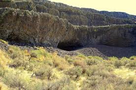
White Bluffs at Hanford Reach

Appearing much different than the nearly ubiquitous Columbia River basalt cliffs and boulders of central Washington, the White Bluffs area features a series of 50-170 m tall buff-colored bluffs and badlands underlain by those basalts. These are outcropping layers of the Ringold Formation comprising most of a 600-ft high escarpment exposed along the north and east banks of the Columbia River in south-central Washington. These ancient river and lakebed sediments were laid down by the Columbia and Snake River systems 8.5 to 3.4 million years ago. However, a section of the White Bluffs are a much younger stack of slackwater rhythmite deposits that filled a paleochannel eroded into the Ringold Formation, These late Ice Age rhythmites are only 17,550-12,500 years old. They were laid down as each of the 40 or more Ice Age Floods backed up behind the narrow constriction at Wallula Gap, submerging the entire White Bluffs area under temporary Lake Lewis. Up to about a dozen rhythmites, composed mostly of sand from as many floods, occur within the channel fill. At the top of most rhythmites is a layer of wind-blown sand suggesting a period of dryness separated each flood. Sediment thicknesses and sedimentary structures in each of the beds give a sense of the tremendous sediment load and the relatively calm conditions of the ponded flood waters. Learn more from Nick Zentner’s 2-Minute Geology video – The White Bluffs at Hanford Reach The White Bluffs are located along the east side of the Columbia River, across from the former towns of Hanford and Whitebluffs, on the Hanford Reach National Monument where the atomic age was born. The bluffs have been exposed by the Columbia River down cutting and moving laterally against the deep silts and sands and old soil horizons that make up the bluffs. These towering white bluffs, massive sand dunes, and the last free flowing nontidal section of the Columbia River all help make the Hanford Reach one of the most dramatic natural areas in the state. Take a Hike on the White Bluffs Rhythmites Trail, Lat, Long: 46.642855, -119.403263
Lake Lenore Caves – Lower Grand Coulee
Tucked into the Lenore Canyon are the Lake Lenore Caves. Along with much of the eastern half of the state, Lenore Canyon was formed during the Missoula floods at the end of the last Ice Age, over 13,000 years ago. The glacial flood waters crashed down the canyon, carving through the basalt that makes up the sheer rock walls, creating coulees, ridges, cliffs, plateaus, rock slides, caves and a series of lakes. The caves themselves are shallow, created during the Great Missoula flood as water pulled chunks of basalt from the walls of the coulee. Post-flood weathering created talus slopes that furnished easy access and temporary overnight camps and storage for at least 5,000 years for hunters and gatherers from villages located elsewhere in the Grand Coulee and along the Columbia River and its tributaries. It is still used today for certain Native American religious ceremonies. It is easy to see why the caves were chosen as a cozy place to stay, as the depth provided plenty of shelter from the elements, while not going so deep that light couldn’t reach the back corners. It is often quite warm and breezy outside, but in the caves it is cool and calm. A well-marked 1.2-mile out-and-back trail leads from the parking area to some of the caves. It is generally considered an easy route that takes an average of 31 min to complete. This is a popular trail for hiking and walking, but you can still enjoy some solitude during quieter times of day. The best times to visit this trail are March through November. Dogs are welcome, but must be on a leash. The coulee walls in this area are made up of Grande Ronde Basalt flows overlain by the Frenchman Springs and Roza members of the Wanapum Basalt. The lower (colonnade) and upper (entablature) cooling units of individual flows are visible in the coulee walls. Flow unit contacts are sometimes complex to interpret. Some flows pinch out against older flows, some are perhaps due to flows covering an irregular topographic surface on the underlying flow, some may be filling of shallow valleys, and some multiple layers may be pulses of lava from the fluid interior pushing out over the partially formed entablature of a previous lava pulse.
McBones – Ice Age Floods Mammoth Dig

The Tri-Cities area, home to the Lake Lewis Chapter of IAFI, is inching its way into spring and it’s time to say goodbye to winter. And for some of us, it’s time to begin the 2023 dig season at Coyote Canyon, the resting place of a 17,500-year-old Columbian mammoth. Coyote Canyon is just a few miles southwest of Kennewick in the Horse Heaven Hills. Last month we cleaned up the winter erosion and set up the field equipment so work can begin in earnest in April. Several bones, yet to be identified, were partially exposed last fall and hopes are high for exposing and removing them this summer. This elephant relative was deposited on the west side of Coyote Canyon during one of the earlier Ice Age floods and is buried by possibly six layers of floods sediment. Numerous erratic rocks have been found among the bones. Just before the pandemic temporarily paused work at the site, a local high school girl was assigned the task of identifying rock types of a cluster of small erratics buried near the animal’s left shoulder blade. She then identified outcrops of the same types of rocks in northern Idaho, at or near the ice dam. Finally, she documented her work with a poster and presented it at the 2019 GSA conference in Portland, Oregon. With digging comes tourism. As usual, public tour lists have filled for spring and summer-fall tour reservations will open on June first. To sign up for a tour the public can visit our new website, www.mcbones.weebly.com. School and private group tours are also available. At the time of this writing, we have scheduled six public tours, 30 elementary class tours and 13 group tours, including one for vision impaired and one for non-English speakers. All of our presentations emphasize the importance of the Ice Age floods to the mammoth story at Coyote Canyon.
Grand Coulee – Geology of the Entire 50 miles

The 50-mile-long Grand Coulee should be on everyone’s bucket list for a “must see” feature. The immense power of the forces that created the Coulee are apparent to those who read the evidence recorded in its rocks and landforms. How did the Coulee form? Why did it form here? What do features like Steamboat Rock, Northrup Canyon, Dry Falls, and the Ephrata Fan tell us about the geological forces that created the Grand Coulee? This presentation will be made May 1, 2023 beginning at 7:00 pm, via Zoom _ https://us02web.zoom.us/j/82985244730 Dr Gene Kiver is professor Emeritus of Geology, Eastern Washington University. He studied alpine glaciation in the Rocky Mountains before moving to Washington State and discovering that J Harlen Bretz had correctly interpreted the bizarre landforms of the Channeled Scabland. Gene taught geology at Eastern Washington University for 34 years. He co-authored “On the Trail of Ice Age Floods” with Bruce Bjornstad that describes the flood history of the northern flood routes of the Missoula Floods. In addition, he authored/co-authored the book “Washington Rocks” and several other books. One item in particular is “Tour Guide Interstate 90 East Tour: Seattle to Spokane” (2007). A CD narration of the people and places as defined by the title. Of the 51 tracks, Dr. Kiver narrates 4 on the Geology of I-90. The Chapter webmaster has ordered it and will update this post after listening to the recording. I bring this up as many of our lectures are about or by people who explored or are exploring the geography of the Ice Age Floods. Look on Amazon under “Eugene Kiver” for this and other books.
Chinook Scenic Byway

The Chinook Scenic Byway is recognized as a premier driving tour in Washington State. The byway travels through the Mt. Baker-Snoqualmie National Forest and Mount Rainier National Park. Experience the diverse landscape of the Central Cascades, from Enumclaw and the glacier-fed White River Valley to the west, up and over 5,430′ Chinook Pass, to the fertile valley of Naches to the east.Visitors experiencing the byway can enjoy spectacular views of dense forests, towering peaks, rocky ridges and river canyons dominate this journey. On a clear day the view of Mount Rainier is breathtaking. Pass through basalt flows of the High Cascades and of the Columbia Plateau, old growth forests, lush subalpine meadows, a world-class ski area and numerous streams, lakes and waterfalls. Not only will you find exceptional scenery, but dozens of opportunities for outdoor fun and recreation await. Be sure to download your free copy of the new byway itinerary. The 25-page guide highlights the history, communities, and environment that make this such a unique drive. The new guide features a map and helps making trip planning easy by highlighting where to stay and play. https://www.youtube.com/watch?v=VakH74S6UyI
Ephrata Erratic Fan

EPHRATA ERRATICS FAN Ice Age Floods National Geologic Trail The Ephrata Erratics Fan is a depositional area south of where water from the Missoula floods poured out of the lower Grand Coulee. It is called a fan because the deposit is spread out like a fan or delta. The basalt and granite boulders now littering the Ephrata Fan were carried there by torrents of water that gushed out of the Grand Coulee. Water and debris exploded from the mouth of the Lower Grand Coulee complex sending debris in a wide swath like pellets from the mouth of a shotgun. Velocity reduction at the coulee mouth and debris momentum carried large boulders a mile or more before they began to settle out of the slowing water stream. The largest of these, “Monster Rock”, is estimated to be about 8m (25 feet) in diameter and contains over 500 cubic yards of rock that weighs over 1,500 tons! “The Ephrata fan is an immense accumulation of gravel and sand that resulted when mega-flood waters from Crab Creek, Dry Coulee, the lower Grand Coulee (ending at Soap Lake), and smaller scabland channels entered the Quincy Basin. The deposit probably formed more in the manner of an immense expansion bar (Baker, 1973a), rather than a fluvial fan in which relatively small alluvial channels shift across the fan surface without ever inundating the entire surface at once. Local areas of surface scour occurred on the fan, the most prominent of which is Rocky Ford Creek. The scour probably developed during waning flood stages, when draining of the inundated Quincy Basin caused relatively steep water-surface gradients to occur over the depositional surfaces that had been constructional during the high stages of megaflooding (Baker, 1973a). The scour processes produced the lag concentration of boulders on the fan surface, many of which can be seen from this viewpoint. An alternative explanation for the morphology of the Ephrata fan is that it was progressively incised by a sequence of multiple floods of successively decreasing magnitudes (Waitt, 1994; Waitt et al., 2009). It may also be that a more complex combination of these mechanisms occurred.” Due to sudden expansion, the floodwaters decelerated and deposited about 130 feet of sediment onto the fan. At the head of the bar, east of Ephrata, are house-size boulders up to 60 feet in diameter. Sediment sizes in the fan decrease with distance south from the mouth of the Grand Coulee. Many of the large boulders that cover the fan are basalt that was likely ripped out of Grand Coulee and other scabland channels just upstream. There are also numerous granitic erratics that were likely carried in the floods from as far away as the Grand Coulee Dam area, over 6o miles north. Quick Facts Location:Hwy 17 south of Ephrata, WA at Hatchery Rd NE. OPEN TO PUBLIC:No MANAGED BY:Private Owner
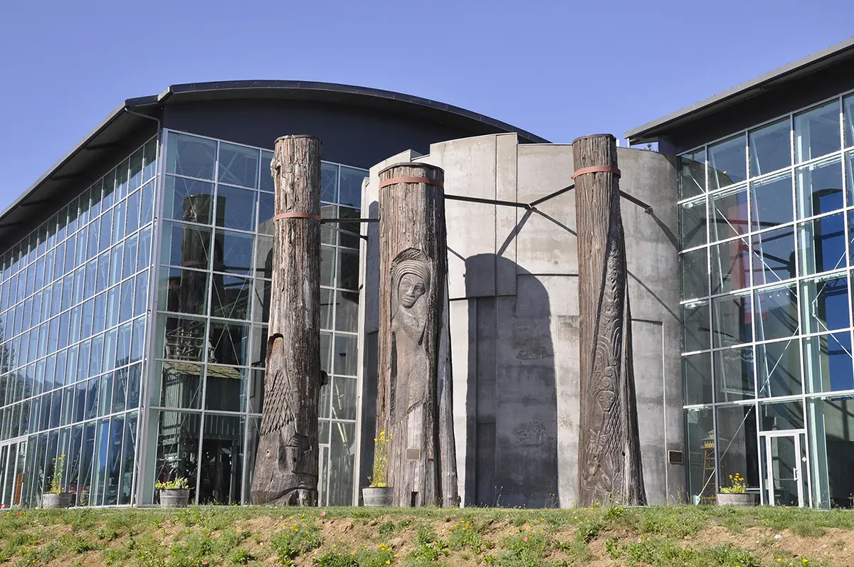
Hanford Reach Interpretive Center and Museum
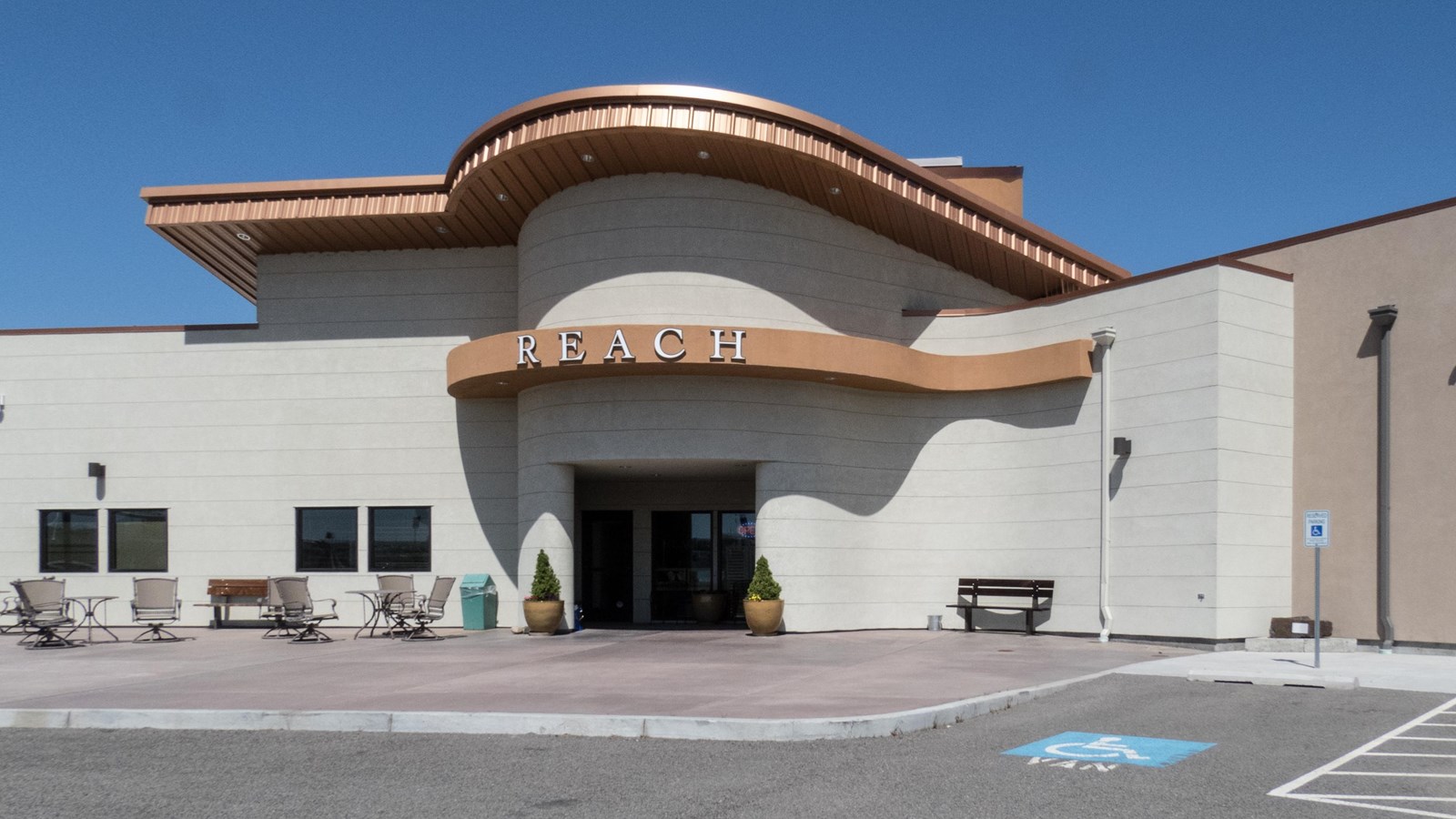
Hanford Reach Interpretive Center and Museum Ice Age Floods National Geologic Trail – Lewis and Clark National Historic Trail At The REACH Museum in Richland, Washington, you can learn about the natural and human history of the Tri-Cities. It houses rotating and permanent exhibits, including a robust exhibit on the Manhattan Project and Cold War. The REACH museum’s outdoor learning area features a sampling of the shrub steppe and riparian ecosystems and provides hands-on activities that are fun while teaching important themes like irrigated agriculture, hops cultivation, local animals, native plants, and land formation. The REACH Museum shares the natural and human history of the Tri-Cities and the surrounding area. The museum takes its name from Hanford Reach, the longest free flowing (undammed), non-tidal section of the Columbia River. The 51mile (82 kilometer) Reach marks the northern and eastern boundary of today’s Hanford Site. Its waters were critical to the site’s plutonium production mission during the Manhattan Project and Cold War. The Hanford Reach’s wild and untamed nature is a direct legacy of the Manhattan Project and the Cold War. Manhattan Project officials removed pre-war agricultural operations and prohibited further development. This formed a large security buffer surrounding the project and inadvertently preserved the shrub steppe ecosystem. When plutonium production stopped, the reduced size of the Hanford Site opened the opportunity for creation of the Hanford Reach National Monument, the US Fish and Wildlife Service’s first national monument. The REACH Museum features rotating and permanent exhibits, including robust presentations on the Manhattan Project, Cold War, indigenous peoples, and cataclysmic ice age floods. An outdoor learning area displays a sampling of the shrub steppe and riparian ecosystems and provides hands-on, interactive activities that are fun while teaching important themes including irrigated agriculture, hops cultivation, local animals, native plants, and land formation. Visit the Reach Museum website for hours of operation and current activities. Quick Facts Location: 1943 Columbia Park Trail, Richland, WA 99352Phone: (509) 943-4100 Hours: Tues-Sat 10:00-4:30Sunday noon-4:30
Grand Coulee Dam Visitor Center
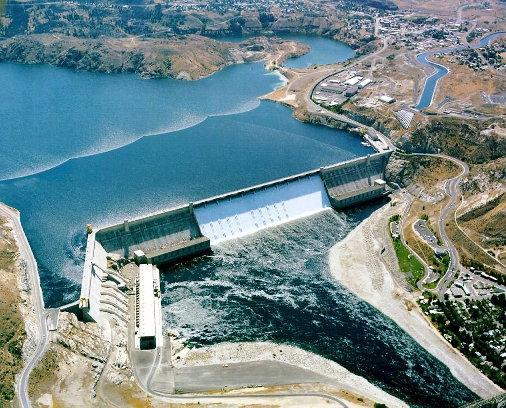
Grand Coulee Dam Visitor Center Ice Age Floods National Geologic Trail | Columbia Basin Project The Columbia Basin Project, which includes Grand Coulee Dam as its main feature, is the Bureau of Reclamation’s largest multipurpose project. Grand Coulee Dam includes three major hydroelectric power generating plants and a pump generating plant. The facilities provide power generation, irrigation, flood control, stream flow regulation for fish migration, navigation, and recreation. When the final generator came online at the Nathaniel Washington Power Plant in in 1980, Grand Coulee Dam became the largest hydropower generating complex in the United States with a generating capacity of more than 6,809-megawatts supplying up to 21 billion kilowatt hours of electricity. In addition, Canada receives power under the Columbia River Treaty. Grand Coulee Dam is operated as part of a coordinated federal system of hydroelectric facilities, which provides 35% of the entire power supply of the Pacific Northwest. The Columbia Basin Project consists of 330 miles of major distribution canals, lakes and reservoirs, and about 2,000 miles of laterals that currently irrigate approximately 680,000 acres of land. In addition, Grand Coulee Dam funds a complex of three hatcheries—Leavenworth, Winthrop and Entiat—collectively known as the Leavenworth Complex, to mitigate for the loss of anadromous fish above the dam. Over 2 million spring chinook and summer steelhead are raised annually. The economic values of the Columbia Basin Project include irrigated crops valued at $1.2 billion annually, hydropower production of approximately $500 million annually, and the prevention of more than $206 million in flood damages since 1950. The Columbia Basin Project also resulted in the creation of vast wetlands and riparian areas and provides recreation benefits to about four million visitors each year. This project made the development of the Pacific Northwest possible and its importance to the nation has been profound. Its influence spread outward to benefit all citizens. Construction of Grand Coulee Dam put thousands to work during the Depression. Grand Coulee’s generators played a vital role in supplying power to build planes, ships, tanks and develop atomic energy during World War II. Following the war, the Columbia Basin Project provided opportunities for returning veterans to farm their own tracts of land. With the completion of the final generating unit in the Nathaniel “Nat” Washington Power Plant, Grand Coulees’ status as the largest hydropower generating facility in the United States was assured, and tangible benefits to Canadian residents were realized. The importance and significance of Grand Coulee Dam and the Columbia Basin Project continue to be realized today. Quick Facts Location: Coulee Dam, WA 99116Phone: (509) 633-9265 The Grand Coulee Dam Visitor Center is open to the public. The “One River, Many Voices” laser light show and the John W. Keys III Pump-Generating Plant public tours resumed May 28, 2022.
Fort Spokane Visitor Center
Fort Spokane Visitor Center Ice Age Floods National Geologic Trail “Fort Spokane is one of the cultural jewels of Lake Roosevelt National Recreation Area. For thousands of years, the area was a gathering place for native tribes fishing the rapids of the Spokane River. In 1880, the U.S. Army established a fort above the confluence of the Spokane and Columbia Rivers. In 1898, the military fort was closed. The buildings were then used as an Indian boarding school and tuberculosis hospital. In many ways, the Indian experience at Fort Spokane is a microcosm of the Indian experience across the United States.” Quick Facts Address: 44150 District Office Ln, Davenport, WA 99122Phone: (509) 754-7893
Columbia Gorge Interpretive Center
Columbia Gorge Interpretive Center Ice Age Floods National Geologic Trail, Lewis & Clark National Historic Trail “Time prints of the millennia are boldly etched on the walls of the Columbia Gorge. They record a 40-million-year-long story of change, endurance and majesty.” Located in the heart of the Columbia River Gorge National Scenic Area, the Columbia Gorge Interpretive Center Museum brings to life the human stories and natural history of one of our nation’s most compelling landscapes. The mission of the Columbia Gorge Interpretive Center Museum is to share the story of Skamania County and the Columbia River Gorge. The Skamania County Historical Society will assemble, collect, preserve, exhibit and make available for future generations any and all historical data, information and artifacts, obtained for the education and enjoyment of Skamania County and Columbia River Gorge residents and visitors. We invite you to come experience 15,000 years of history. The logo for the Columbia Gorge Interpretive Center is the petroglyph, “Tsagaglalal” or “She Who Watches.” Tsagaglalal is located on a cliff overlooking the Columbia River at Columbia Hills State Park (formerly known as Horse Thief State Park) in Washington. It is one of the best examples of aboriginal art in the United States. The largest gallery in the museum is Harvesting Resources, which focuses on the timber and fishing industries in the Gorge. It also contains a waterfall. Four very large artifacts are on display. The First Peoples exhibit focuses on the history of the original people to live in this area of the Gorge, the Cascade Chinook. The Emory Strong Library is also visible, showing his collection of early-man artifacts. Quick Facts Location: 990 SW Rock Creek Dr, Stevenson, WA 98648Phone: (509) 427-8211