The Bowl & Pitcher at Riverside State Park
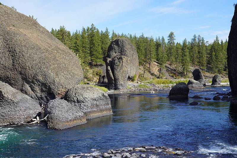
The Bowl and Pitcher is a rock formation along the Spokane River and one of the most scenic sites in the area, with basalt cliffs rising 500 feet above the river and large blocks of basalt in the river causing large rapids. The “Bowl” is a circular depression in the river and the “Pitcher” is a large detached block of highly fractured basalt. The geology of Spokane’s Bowl and Picher features dramatic basalt cliffs carved out of the flows from the Columbia River Basalt Group (CRBG), which reached this area 16 million years ago. There are river and flood deposits of sand and gravel, with granitic boulders forming terraces on the east side of the river, and huge blocks of basalt, causing the Dragon Tooth rapids, downriver from the Bowl and Pitcher. How did those rocks get there? The Spokane and Columbia rivers occupy a long, mostly bedrock canyon near the northeastern boundary of the Columbia Plateau. Glacial Lake Columbia, which formed behind the Okanogan ice lobe, occupied all of the Spokane River and a portion of the Columbia drainage basin during the last Ice Age. Then the glacial Lake Missoula outburst floods first surged over the Columbia Basin beginning around 17,000 years ago, ripping away the CRBG and other bedrock from Bayview, Idaho, to the Pacific Ocean. These floods also deposited a thick sequence of flood gravel in the valley. As Lake Columbia water level dropped, the Spokane River began to remove the sand and gravel fill. Subsequent floods continued to remove the flood deposits, leaving the basalt benches on the west side of the river and the terraces on the east side. Riverside State Park is located northwest of Spokane and consists of over 9000 acres along the Spokane and Little Spokane Rivers. The park is the second largest state park and has many recreational activities including, camping, hiking, mountain biking, horseback riding and boating (Discover Pass required). There are two view points for the Bowl and Pitcher. The first is from a small parking lot off the entrance road from Aubry White Parkway that provides an elevated view of the site. The main parking area is down along the river with a picnic area and a network of trails. From the parking lot you can follow the wheelchair accessible path across the suspension bridge over the Spokane River. From the bridge you can enjoy a view of the features that give the site its name. The original bridge was built in 1942 by the Civilian Conservation Corps. The existing bridge, based on the same plans, opened in 1998. On the west side of the river, you can access a network of trails along the river or climb up along the bluffs above the river.
Moses Coulee: An Ice Age Enigma

Washington state is famous for its dramatic landscapes, many carved by the immense power of the Ice Age Floods. We know the stories of the Grand Coulee, Palouse Canyon, and the Potholes. But tucked away in north-central Washington, cutting a path from northeast to southwest across the Okanagan Plateau, lies Moses Coulee – perhaps the most mysterious of them all. Unlike its famous cousins, Moses Coulee doesn’t quite fit the standard narrative. Its head seemingly emerges from beneath the Wisconsin Withrow Moraine, and its very formation presents a fascinating puzzle for geologists. Flood Theories and Questions: An Enigma The Grand Coulees (Upper and Lower) are widely believed to have been carved by the spectacular Missoula Floods. These colossal deluges were unleashed when the Okanagan Lobe of the Cordilleran Ice Sheet blocked the Columbia River, redirecting massive amounts of water southward. For Moses Coulee, it’s not so clear-cut. While cataract retreat due to massive floodwaters is generally assumed, most theories suggest the Okanagan Lobe effectively blocked the Missoula Floods from entering Moses Coulee. So, what carved this impressive landscape? Enter J. Harlan Bretz, the pioneering geologist who first championed the idea of colossal floods shaping the Pacific Northwest. Bretz observed a distinct wide bench within Moses Coulee, high above its floor. This led him to speculate about two distinct periods of glacial floods: An older, pre-Wisconsin “Spokane Flood” that initially carved Moses Coulee. A later Wisconsin period flood (what we now call the Missoula Floods) that deepened the coulee floor. Interestingly, current speculation suggests the Upper Grand Coulee might also owe its primary formation to these earlier “Spokane Floods,” with the Lower Grand Coulee being a product of the later Missoula Floods. It seems the story of Washington’s coulees is far more layered than once thought! Beyond Glacial Lakes: A Subglacial Hypothesis But wait, there’s another fascinating idea. Some investigators propose that Moses Coulee wasn’t carved by the well-known Missoula or Columbia glacial lake outbursts at all. Instead, they suggest outbreak floods from under the ice sheet itself. Joel Gombiner and Jerome Lesemann have explored this idea, suggesting that the immense pressure of the overlying ice lobe could have forced subglacial meltwater to flow uphill over topographic highs. This water would then have exited from under the ice, becoming the powerful floodwaters that sculpted Moses Coulee. Imagine that — floods erupting from beneath a massive glacier! Explore the Mystery Yourself The interplay between the Withrow Moraine and the unique features of Moses Coulee makes this a truly captivating area for exploration, especially for those intrigued by the raw power of ancient ice and water. To truly enhance your visit to this less-traveled gem, we highly recommend: Watching several of Nick Zentner’s insightful videos where he dives deep into these Moses Coulee questions. His engaging explanations bring the geology to life! Examining J. Harlan Bretz’s original field notes, meticulously organized in geolocated Google Maps by Glenn Cruickshank. It’s like stepping back in time with the pioneering geologist himself. Moses Coulee is more than just a landscape; it’s an ongoing geological debate etched into the earth. Are you ready to explore this remarkable natural mystery? AI-assisted article by Lloyd DeKay – Columbia River Gorge Chapter
Palouse Falls State Park

Palouse Falls State Park, dedicated in 1951, is a 94-acre park showcasing the dramatic Palouse Falls and its unique geological history. The park is a popular destination for viewing the falls, which were formed by Ice Age floods and are a key part of the Ice Age Floods National Geological Trail. The falls were designated as Washington’s state official waterfall in 2014, thanks to the advocacy of schoolchildren from Washtucna. Palouse Falls is one of four of the last remaining year-round waterfalls on the Palouse River that once stood in the path of the ice age floods. It is rich in both geological and human history. The native Palouse Indians called it “Aput Aput” meaning “falling water.” They believed that it was created by the Great Spirit because of his displeasure with the wicked Indians who lived further upstream. This obstacle was a barrier that allowed the salmon to travel no further. Sam Fisher, a Palouse Indian, also tells the story of how four giant brothers and their giant sister used oil from beaver tails to keep their hair shiny. Needing more oil, they searched for the giant beaver and fought with him. All four falls on the river were made when the beaver slapped his tail. At the last battle at Palouse Falls, the beaver struck his tail one last time creating the falls and the bowl it falls into. The vertical cracks in the basalt were made by the claws of the beaver. Palouse Falls has made a powerful impression on all who have visited. For example, one of the fall’s earliest visitors, Laurence L. Dodd in 1867, described the site he saw this way: “just before descending the Snake River hill your eye rests on the grateful green bottom of the Palouse with its clear and pure waters, flowing into the turbid Snake and after ascending the Snake River hill to the northward and eastward, the eye sweeps over a vast extent of country rarely surpassed in rugged desolation and wildness.…” Dodd was accompanied by a few local citizens from Starbuck on horseback to witness the scene he described. Early access to the falls was either by train (many passenger trains would stop here for their passengers to look at the falls) or by coming in from the east side. Robert E. Strahorn, who built the railroad up the Palouse Canyon had the original idea of making Palouse Falls a State Park. But it was not until years later that Washtucna area resident and president of the Washtucna Community Service Club John H. Baumann really pushed the idea. In 1945, Palouse Falls State Park was created. It was dedicated on June 3rd, 1951. The 299 acres that make up the entirety of this vast park were donated by The Baker-Boyer National Bank of Walla Walla, J.M. McGregor of the McGregor Land and Livestock Company of Hooper, and Mrs. Agnes Sells, a resident of Washtucna. Palouse Falls State Park is located off Highway 261, which branches off Highway 260 out of Washtucna. The most popular season for visiting is in the spring when the river is at its highest from winter snow melt. However, each season has its own story to tell as these pictures show. Article by Lloyd Stoess, President IAFI Palouse Falls Chapter
Coyote Canyon Mammoth Dig

The Coyote Canyon Mammoth Dig is an active paleontological excavation site in the Horse Heaven Hills near Kennewick, Washington. It’s a significant project that sheds light on the history of the Ice Age floods in the Tri-Cities area. The dig focuses on the unearthed remains of a Columbian mammoth that lived approximately 17,500 years ago. The mammoth’s carcass was buried in Touchet beds, a geological formation laid down by ancient floods. The site sits at an elevation of 1040 feet above sea level, which is considerably higher than the current elevation of the Columbia River, which is only 350 feet above sea level about 7 miles north. Scientists estimate that Lake Lewis, a massive glacial lake that existed during the Ice Age, reached a maximum surface elevation of over 1200 feet above sea level at the time the mammoth perished. This substantial difference in elevation hints at the immense power of the Ice Age floods that swept across the region. Another fascinating aspect of the Coyote Canyon Mammoth Dig is the discovery of a vast pile of erratic rocks. Initially thought to be a small cluster, the collection of these displaced rocks has grown to extend into several adjacent dig units. A dig unit, for those unfamiliar with archaeological and paleontological fieldwork, is a standardized square measuring 2 meters by 2 meters that archaeologists and paleontologists use to meticulously excavate and collect data. The MCBones Research Center, a non-profit organization, spearheads the Coyote Canyon Mammoth Dig. They offer educational tours for schools and other groups, providing a firsthand look at this significant paleontological excavation. These tours are a great opportunity to learn more about the Ice Age floods, mammoths, and the meticulous work of paleontologists. For more information about the Coyote Canyon Mammoth Dig, including details about tours, visit the MCBones Research Center website at www.mcbones.org.
Visit Wenatchee, Washington – Explore Ice Age Flood Features

Wenatchee, Washington is often called the “Apple Capital of the World” or the “Buckle of the Power Belt of the Pacific Northwest”. Today the Wenatchee vicinity is known for the fruit industry, wineries, power generation, tourism and outdoor recreation. When you visit and look around the Wenatchee Valley, even today, much of the landscape was formed by Ice Age Flooding. Visit the Wenatchee Valley area to explore some of the interesting Ice Age Flood features found there. Toward the end of the Pleistocene Ice Ages (17,000-12,000 years ago) much of the landscape in the Wenatchee area was changed substantially by catastrophic ice-age flooding. These flood(s), almost 1,000 feet deep, initiated out of glacial Lake Missoula in Montana, and some of the largest came through the Wenatchee area along the Columbia River drainage. Prior to the Okanogan Ice Lobe blocking the Columbia River valley north of Wenatchee, the early Missoula flood(s) could follow the present day path of the Columbia River around the “Big Bend” area of north-central Washington into the Wenatchee area and further south. Take a drive north of Wenatchee on highways US 97 or US 97A to see evidence of this flooding. As the Okanogan Ice Lobe advanced south it eventually blocked the Columbia River drainage north of Wenatchee. The water backed up by that Okanogan Lobe ice dam formed glacial Lake Columbia and forced subsequent ice-age floods to be funneled southward along the east edge of the ice lobe into Moses and Grand Coulees, and farther east through the Channeled Scablands of eastern Washington. When the Okanagan ice eventually retreated, one last flood from glacial Lake Columbia again followed the Columbia drainage through Wenatchee. Massive boulders (some 40 feet in diameter) and erratics (rocks foreign to the area) were transported at the base of the flood waters and embedded in huge icebergs floating on the floodwaters. They were deposited along the hillsides throughout the Wenatchee area as the floods waned and the icebergs became stuck and melted. Those erratics prompted our Ice Age Floods Institute chapter name “The Wenatchee Valley Erratics”. The two main erratic rock types in this area, granite and gneiss, are much different from the Eocene Chumstick Sandstone bedrock. The gneiss erratics transported a relatively short distance from outcrops just north of Wenatchee are often 10 feet in diameter. The nearest granite outcrops occur some 15 miles upstream in the Entiat area, so the granite erratics tend to be smaller, less than 3 feet in diameter. Some of the best locations to see these erratics are just south of the Old Wenatchee Bridge (first bridge over the Columbia River finished in 1908) along the Apple Capital Loop Trail near Patriot Plumbing & Heating, the Department of Social & Health Services and near the old train at Mission Street Park in south Wenatchee. An enormous crescent-pendant Pangborn Bar topped with huge current ripples was deposited in east Wenatchee where the Columbia River drainage takes a right (easterly) turn. The bar elevation is 500 feet above the Columbia River today. On the surface of Pangborn Bar are giant current ripples with crests up to twenty feet tall and ripples spaced some 300 feet apart. Travel up Grant Road, 4th Street in East Wenatchee and then out onto Batterman Road northwest of Rock Island to travel across the entire Pangborn Bar from west to east. The giant current ripples are best observed on 2nd or 4th Streets, where these roads go up and over the current ripples east of Nile Avenue in East Wenatchee, Washington. Just about a mile northeast of Pangborn Memorial Airport is a very significant archaeological site, the East Wenatchee Clovis Site (Richey Clovis Cache), discovered in 1987 and excavated until the site was closed and covered in 2004. This site lies on top of one of these current ripples. Pristine Clovis spear points as well as other archaeological specimens (about 11,000 years old) were discovered and some are now on display at the Wenatchee Valley Museum and Cultural Center in Wenatchee. Article from Brent Cunderla, April 2024
Postmortem on the southern Cordilleran Ice Sheet

(21Feb2024) On 18 March 2924 at 7:00pm the Puget Lobe Chapter io the IAFI will have Dr Ralph A Haugerud give his presentation “the Postmortem on the Southern Cordilleran Ice sheet. Death of an ice sheet can have many causes, as shown by retreat of the southern Cordilleran ice sheet about 15,000 years ago. East of the Cascades, the margin of active south-flowing ice retreated north as less snow fell and more melted. West of the Cascades, the Juan de Fuca lobe of the ice sheet appears to have floated away in response to rising sea level, perhaps without a proximal climatic cause. Collapse of the Juan de Fuca lobe diverted ice from the Puget lobe, which consequently stagnated at its margin and rapidly melted back. Later Sumas ice readvance in the Fraser Lowland may reflect stabilization of the remnant ice sheet by grounding as local sea level fell, followed by climate-driven retreat. Ralph Haugerud received B.S. and M.S. degrees in Geology from Western Washington University and a Ph.D. in Geological Sciences from the University of Washington. Since joining the USGS in 1986, he has worked in the North Cascades Range, the Salish Lowland, and the Columbia Plateau. From 1990 to 2014 he was technical lead for the Puget Sound Lidar Consortium, and he has been instrumental in developing the GeMS standard for representing geologic maps in a Geographic Information System (GIS). His current efforts focus on the structure of Eocene strata in central Washington, features formed by glacial Lake Missoula outburst floods, and regional map compilation. The in-person portion will be at Bellevue College Bldg R, Rm R103. See separate post for location details. For this meeting only there will be NO “Zoom” available.
The Bretz Journals and Google Earth

If you have been following Professor Nick Zentner (CWU) on YouTube, you may know that one of the treasures he has uncovered with the help of collaborators are the Bretz journals from field research done from 1919 through 1929. After Bretz’s death in 1981, his family donated his papers to the University of Chicago Library and though they were available to the public, access was very limited. Just recently Professor Zentner was able to obtain whole-hearted permission from Bretz’s family to share them more widely. Because of this, scans have been made of the journals and PDF’s are now available on Nick’s website for viewing and downloading. In November, 2023 Nick began a new series called “Ice Age Floods A to Z.” (The videos are recorded and can be viewed on YouTube.) During session I, Nick invited viewer Glenn Cruickshank (Liberty Lake, WA) to share about how to use Google Earth to view the travels of J Harlen Bretz based on his field journals. Glenn had the idea that he could transfer Bretz journal locations to Google Earth; in doing so he has created files for each of the Bretz’s years in the Northwest! All of Glenn’s work has been linked on Nick Zentner’s website. Using Google Earth with Glenn’s files, a marker appears on the map for each location that Bretz visited during a particular year and includes a snippet of his notes. The map points are all identified by year and by journal page. Not only can you zoom into the satellite images, but you can also use the ‘Street View’ feature to see various outcrops along roads that still exist today. Google Earth is a free program and can be used on the web, or as an app you can download for a mobile phone, tablet, or your computer (PC, Mac, or Linux). It is similar to Google Maps, but with many more capabilities. If you are just getting started with it, you may want to check out one of the many beginner tutorials on YouTube. Glenn has included step by step instructions on how to load the Bretz Files into Google Earth from Nick’s site. Using the journals and Glenn’s Google Earth files, you can follow along with Bretz’s field travels year by year.
Journey Through Time: Explore Drumheller Channels

Nestled in the heart of Washington state, the Drumheller Channels offer a unique glimpse into earth’s history, carved by the immense power of Ice Age Floods. This National Natural Landmark is a must-visit for anyone seeking breathtaking landscapes, remarkable geological formations, and a chance to understand the power of nature. Witness the Scars of Ancient Floods: Drumheller Channels are a remarkable example of the Channeled Scablands, a vast landscape sculpted by cataclysmic floods that roared across the region millennia ago. Hike or bike through dry riverbeds, past towering basalt cliffs, and over rolling hills, all remnants of these powerful events. Imagining the colossal force of water that once flowed through these channels is an awe-inspiring experience. Explore Diverse Landscapes: The Channels offer a variety of landscapes, each offering its own unique charm. Hike along the McManamon Trail for panoramic vistas of the Scablands, or venture into the Crab Creek Unit to discover hidden waterfalls and basalt columns. For a unique perspective, climb to the top of “Nick’s Columns” and marvel at the vastness of the Channeled Scablands. A Haven for Wildlife: The diverse ecosystem within the Drumheller Channels provides a sanctuary for various wildlife species. Birdwatchers can spot over 23 species of ducks and geese, while sharp-eyed visitors may catch a glimpse of deer, coyotes, and even bald eagles. The Channels are also a vital nesting ground for many birds, making it a crucial habitat for preserving regional biodiversity. Connect with the Past: Explore the fascinating human history of the Drumheller Channels. The region has been inhabited for thousands of years, with evidence of Native American presence found throughout the area. Learn about the early settlers who braved the rugged landscape and contributed to the development of the region. A Place for Recreation and Reflection: Whether you’re an avid hiker, a passionate photographer, or simply seeking a peaceful escape, Drumheller Channels has something for everyone. Hike through scenic trails, enjoy a picnic amidst the breathtaking scenery, or simply relax and soak in the tranquility of nature. Plan Your Visit: The Drumheller Channels are open year-round and offer free access. Several trailheads provide easy access to various sections of the Channels. The Ice Age Floods Institute offers valuable resources, including maps, trail descriptions, and educational information. Be sure to pack sturdy shoes, appropriate clothing for the weather, and plenty of water for your adventure. Come experience the grandeur and wonder of the Drumheller Channels. Witness the power of nature etched into the landscape, explore the diverse ecosystem, and connect with the rich history of this remarkable place. It’s a journey through time that will leave you with a lasting sense of awe and appreciation for the natural world.
Let Your Feet, and Your Imagination Roam at Rowena Crest and Tom McCall Preserve

Scenic Rowena Crest and the Tom McCall Preserve area provide an incredibly scenic place to let your feet, and your imagination wander as you look out on a major chokepoint along the Ice Age Floods path. The wildflower displays are amazing during the Spring, but several compelling flood-related features are visible from the vantage of the Rowena Crest Viewpoint any time of year. Rowena Crest lies nearly 700 feet above the Columbia River at the upstream end of the Rowena Plateau, a miles-long plateau that the river flows along. Just upriver from the plateau is the narrow section of the Gorge known as the Rowena Gap The drive to the viewpoint on old Hwy 30 from either east or west is a spectacular ride through a wonderous section of the Columbia River Gorge. A roundabout parking area at the viewpoint, with a safety wall above a sheer cliff, provides a great observation point eastward toward Rowena Gap. At Rowena Crest it’s easy to imagine what it might have been like to witness the approach of those massive floods. There is not yet scientific evidence that humans were in the area to bear witness to the Ice Age Floods, but there is solid evidence of humans in the Americas by that time. And there is growing concensus that if they came in during a glacial maximum, they would have come in by a coastal route that offered plentiful food and shelter for their journey. The mouth of the Columbia River would have been the first major waterway path inland that might have led them to settle in the area of the Floods. Your village might have been situated across the Columbia at the mouth of the Klickitat River where the town of Lyle now sits. If you were foraging, or just relaxing, atop Rowena Crest on a late summer day, you might have felt the ground begin to temble as if there were a small earthquake, but the trembling would have slowly increased for a few hours. Eventually you would have heard a low roaring sound that also grew over an hour or more before you could see turbulent brown muddy water begin flooding across the broad basin to the east. Then the roaring flood of water, only a few feet deep at first, would have entered the narrows, now called Rowena Gap, and sped on, crashing against the promontory you’re standing on and being diverted toward your village which was quickly washed away by the muddy torrent. But the muddy flood waters would have kept rising, unlike the Spring floods you’re used to on the Columbia, becoming a hundred feet deep, then two hundred as the levels just kept rising. Soon a huge whirlpool formed in the flood waters near the base of the promontory and a giant eddy formed where your village had been as flood waters flowed backward up the Klickitat River even as the bulk of the water continued downstream on the main stem of the Columbia. As the flood waters reached 400 and 500 feet deep and kept coming, suddenly to your right and left, huge blocks of the promontory broke off and slumped down into the rampaging flood waters. Now, even more fearful, you would have begun running south toward higher ground, climbing higher and higher as the still rising flood waters poured across the plateau and plunged into the small creek valley to the west, tearing away at the valley walls and massively widening that little valley. Eventually the flood waters stopped chasing you upward as you climbed higher, 200 then 300 feet above the now submerged promontory. Now, as you turned and looked out across that expanse of muddy water you could see massive white blocks of ice being carried along on the flood waters, similar but inconceivably larger than the ice blocks carried on the river during the Spring floods. But the flood waters didn’t begin to recede that day, nor the next, as they might in the Spring floods. In fact it was almost half a lunar cycle before they began to slowly recede, exposing a mud coated Columbia River valley that was now noticeably wider, with layers of shear vertical rock walls extending over 1000 feet above the normal river level below. As you began the recovery from the floods devastation, your family returned from from their hunting and gathering in the high mountain meadows, and you have an incredible story to pass along to them and your ancestors. This story is easy to imagine as you look out to the east from Rowena Crest. The onrushing Ice Age Floods waters easily flowed over the low relief of the broad Dalles Basin to the east, but the major Rowena Gap created a chokepoint in the path of the floods as they made their way through the Columbia River Gorge. This “hydraulic dam” forced the flood waters to build to over 1000 feet deep in this area, flowing hundreds of feet deep over Rowena Crest while forming a temporary lake in The Dalles basin. It is estimated that many of the 40-100 Ice Age Floods may have taken up to a month to completely flush through the system to the Pacific Ocean, but the duration of the flood waters at any point along the path probably lasted less than a couple of weeks. But this was more than enough to create several major floods features visible from this vantage point. At Columbia River level below and east of the promontory is a round Kolk pond that was created by giant whirlpools in the flood waters as they were deflected around the Rowena Crest promontory. Other similar Kolk features can also be seen on the Dallesport area to the east, and along the hiking path atop Rowena Crest where they are marked by surrounding groves of oak trees. Across the Columbia, the floods deposited a huge eddy gravel bar that the entire town of Lyle, Washington is built upon. The Klickitat River was backed
Puget Sound Area has a Glacial Story to Tell

Although the Seattle region was not impacted by the large floods from Glacial Lake Missoula, Glacial Lake Columbia, or other glacial lakes east of the Cascades, the Puget Sound region has its own glacial story to tell. It’s interesting that J Harlen Bretz, who first imagined that a massive flood produced the Floods features in the Columbia Plateau, also did his PhD on “Glaciation of the Puget Sound Region”. The Puget Lobe of the Cordilleran Ice Sheet advanced and retreated over the Puget Lowland at least seven times during the Quaternary Ice Age. In the process, it left behind rocks, sediments, and other geologic clues that tell the intriguing story of ice, proglacial lakes, and flooding across the landscape near Seattle. Snoqualmie Falls, near North Bend, WA east of Seattle is a popular tourist destination. At the falls, the Snoqualmie River plunges 82m over a wall of volcanic rock. Few tourists, however, understand the role that the Puget Lobe of the Cordilleran Ice Sheet played in the formation of the falls. Prior to glaciation, Snoqualmie Falls did not exist, instead, the river flowed in an incised channel east of the current falls. As the Puget lobe advanced into the Puget Lowland about 18,700 years ago, the glacier’s eastern margin blocked drainage from rivers flowing out of the Cascades, including the Snoqualmie River. A large glacial lake known as Glacial Lake Snoqualmie formed over North Bend and over the Snoqualmie Valley. Tokul Creek, one of the tributaries, formed a thick underwater delta in the lake as its sediments poured into Glacial Lake Snoqualmie. When the Puget Lobe retreated, Glacial Lake Snoqualmie drained to the west and the Snoqualmie river attempted to follow its original channel. However, the original course of the river was blocked by the delta deposits from Tokul Creek and the river was forced to flow over a narrow band of rocks from an eroded volcano further to the south. Snoqualmie Falls flows over this volcanic rock today, but since the last glacial maximum, cataract recession has rapidly eroded the rocks back to a 200m wide band of andesite and volcanic breccia. Behind the thin volcanics is a thick layer of soft alluvium. At the current rate of recession, the Snoqualmie River will erode through the volcanic rock in about 7,200 years. When that happens, the river will hit the alluvium and the falls will quickly devolve into a series of rapids. You might want to hurry to see the falls before they disappear! Other glacial lakes were formed at the southern margin of the Puget Lobe near modern day Seattle. As the Puget Lobe advanced south, it dammed rivers and streams that were flowing north. In places, the bluffs surrounding modern Puget Sound hold a record of the advancing glacier and the pro-glacial lakes backed up by the ice front. One good place to view these sediments is from the beach at Discovery Park in Seattle. A layer cake of sedimentary units records the pre-glacial river system, the advance of the ice, the damming of the proglacial lakes, and the retreat of the ice sheet to the north. At the base of the cliffs the Olympia Formation records the pre-glacial environment of north-flowing rivers and streams. The Lawton Clay layer indicates the formation of proglacial lakes. The Esperance sand represents a period of glacial retreat. The glacier that repeatedly covered the Puget Lowland left behind multiple geologic clues for us to interpret. The Puget Lobe of IAFI welcomes members from other chapters to join us as we explore the glacial history of the Puget Lowland.