Oregon Museum of Science and Industry

Oregon Museum of Science and Industry Ice Age Floods National Geologic Trail The Oregon Museum of Science and Industry (OMSI) in Portland, Oregon, was founded in 1944. OMSI is one of the nation’s leading science museums and a trusted educational resource for communities throughout Oregon and the region. Through museum exhibitions, public programs at the museum and across the region, outdoor programs, traveling exhibitions, digital learning, and learning research and design, OMSI nourishes a lifelong love of science, curiosity and learning for diverse audiences. OMSI’s mission is to inspire curiosity through engaging science learning experiences, foster experimentation and the exchange of ideas, and stimulate informed action. OMSI’s vision is to collaborate with partners to ignite an education transformation at the intersection of science, technology, and design. We will weave a thriving innovation district into the fabric of Portland that spreads opportunities across the Northwest. Quick Facts Museum Hours as of Sept 6Tues-Sun 9:30-5:30 Visitor Informationhttps://omsi.edu/visitor-info
Hanford Reach Interpretive Center and Museum
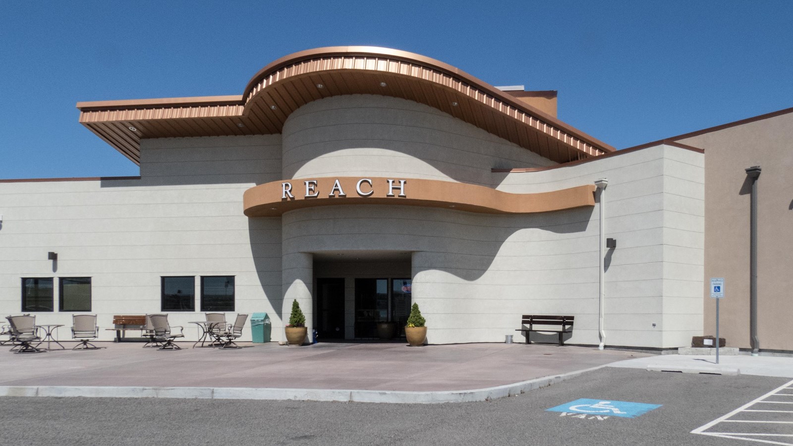
Hanford Reach Interpretive Center and Museum Ice Age Floods National Geologic Trail – Lewis and Clark National Historic Trail At The REACH Museum in Richland, Washington, you can learn about the natural and human history of the Tri-Cities. It houses rotating and permanent exhibits, including a robust exhibit on the Manhattan Project and Cold War. The REACH museum’s outdoor learning area features a sampling of the shrub steppe and riparian ecosystems and provides hands-on activities that are fun while teaching important themes like irrigated agriculture, hops cultivation, local animals, native plants, and land formation. The REACH Museum shares the natural and human history of the Tri-Cities and the surrounding area. The museum takes its name from Hanford Reach, the longest free flowing (undammed), non-tidal section of the Columbia River. The 51mile (82 kilometer) Reach marks the northern and eastern boundary of today’s Hanford Site. Its waters were critical to the site’s plutonium production mission during the Manhattan Project and Cold War. The Hanford Reach’s wild and untamed nature is a direct legacy of the Manhattan Project and the Cold War. Manhattan Project officials removed pre-war agricultural operations and prohibited further development. This formed a large security buffer surrounding the project and inadvertently preserved the shrub steppe ecosystem. When plutonium production stopped, the reduced size of the Hanford Site opened the opportunity for creation of the Hanford Reach National Monument, the US Fish and Wildlife Service’s first national monument. The REACH Museum features rotating and permanent exhibits, including robust presentations on the Manhattan Project, Cold War, indigenous peoples, and cataclysmic ice age floods. An outdoor learning area displays a sampling of the shrub steppe and riparian ecosystems and provides hands-on, interactive activities that are fun while teaching important themes including irrigated agriculture, hops cultivation, local animals, native plants, and land formation. Visit the Reach Museum website for hours of operation and current activities. Quick Facts Location: 1943 Columbia Park Trail, Richland, WA 99352Phone: (509) 943-4100 Hours: Tues-Sat 10:00-4:30Sunday noon-4:30
Grand Coulee Dam Visitor Center
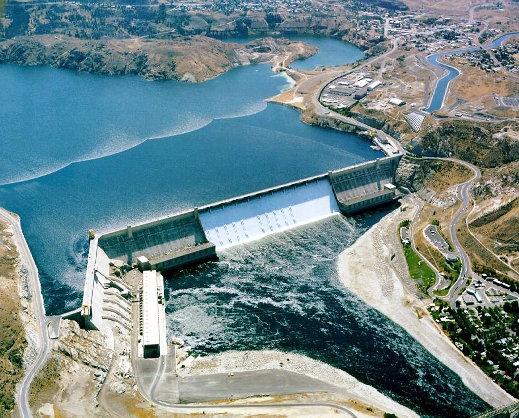
Grand Coulee Dam Visitor Center Ice Age Floods National Geologic Trail | Columbia Basin Project The Columbia Basin Project, which includes Grand Coulee Dam as its main feature, is the Bureau of Reclamation’s largest multipurpose project. Grand Coulee Dam includes three major hydroelectric power generating plants and a pump generating plant. The facilities provide power generation, irrigation, flood control, stream flow regulation for fish migration, navigation, and recreation. When the final generator came online at the Nathaniel Washington Power Plant in in 1980, Grand Coulee Dam became the largest hydropower generating complex in the United States with a generating capacity of more than 6,809-megawatts supplying up to 21 billion kilowatt hours of electricity. In addition, Canada receives power under the Columbia River Treaty. Grand Coulee Dam is operated as part of a coordinated federal system of hydroelectric facilities, which provides 35% of the entire power supply of the Pacific Northwest. The Columbia Basin Project consists of 330 miles of major distribution canals, lakes and reservoirs, and about 2,000 miles of laterals that currently irrigate approximately 680,000 acres of land. In addition, Grand Coulee Dam funds a complex of three hatcheries—Leavenworth, Winthrop and Entiat—collectively known as the Leavenworth Complex, to mitigate for the loss of anadromous fish above the dam. Over 2 million spring chinook and summer steelhead are raised annually. The economic values of the Columbia Basin Project include irrigated crops valued at $1.2 billion annually, hydropower production of approximately $500 million annually, and the prevention of more than $206 million in flood damages since 1950. The Columbia Basin Project also resulted in the creation of vast wetlands and riparian areas and provides recreation benefits to about four million visitors each year. This project made the development of the Pacific Northwest possible and its importance to the nation has been profound. Its influence spread outward to benefit all citizens. Construction of Grand Coulee Dam put thousands to work during the Depression. Grand Coulee’s generators played a vital role in supplying power to build planes, ships, tanks and develop atomic energy during World War II. Following the war, the Columbia Basin Project provided opportunities for returning veterans to farm their own tracts of land. With the completion of the final generating unit in the Nathaniel “Nat” Washington Power Plant, Grand Coulees’ status as the largest hydropower generating facility in the United States was assured, and tangible benefits to Canadian residents were realized. The importance and significance of Grand Coulee Dam and the Columbia Basin Project continue to be realized today. Quick Facts Location: Coulee Dam, WA 99116Phone: (509) 633-9265 The Grand Coulee Dam Visitor Center is open to the public. The “One River, Many Voices” laser light show and the John W. Keys III Pump-Generating Plant public tours resumed May 28, 2022.
Fort Spokane Visitor Center
Fort Spokane Visitor Center Ice Age Floods National Geologic Trail “Fort Spokane is one of the cultural jewels of Lake Roosevelt National Recreation Area. For thousands of years, the area was a gathering place for native tribes fishing the rapids of the Spokane River. In 1880, the U.S. Army established a fort above the confluence of the Spokane and Columbia Rivers. In 1898, the military fort was closed. The buildings were then used as an Indian boarding school and tuberculosis hospital. In many ways, the Indian experience at Fort Spokane is a microcosm of the Indian experience across the United States.” Quick Facts Address: 44150 District Office Ln, Davenport, WA 99122Phone: (509) 754-7893
Columbia Gorge Interpretive Center
Columbia Gorge Interpretive Center Ice Age Floods National Geologic Trail, Lewis & Clark National Historic Trail “Time prints of the millennia are boldly etched on the walls of the Columbia Gorge. They record a 40-million-year-long story of change, endurance and majesty.” Located in the heart of the Columbia River Gorge National Scenic Area, the Columbia Gorge Interpretive Center Museum brings to life the human stories and natural history of one of our nation’s most compelling landscapes. The mission of the Columbia Gorge Interpretive Center Museum is to share the story of Skamania County and the Columbia River Gorge. The Skamania County Historical Society will assemble, collect, preserve, exhibit and make available for future generations any and all historical data, information and artifacts, obtained for the education and enjoyment of Skamania County and Columbia River Gorge residents and visitors. We invite you to come experience 15,000 years of history. The logo for the Columbia Gorge Interpretive Center is the petroglyph, “Tsagaglalal” or “She Who Watches.” Tsagaglalal is located on a cliff overlooking the Columbia River at Columbia Hills State Park (formerly known as Horse Thief State Park) in Washington. It is one of the best examples of aboriginal art in the United States. The largest gallery in the museum is Harvesting Resources, which focuses on the timber and fishing industries in the Gorge. It also contains a waterfall. Four very large artifacts are on display. The First Peoples exhibit focuses on the history of the original people to live in this area of the Gorge, the Cascade Chinook. The Emory Strong Library is also visible, showing his collection of early-man artifacts. Quick Facts Location: 990 SW Rock Creek Dr, Stevenson, WA 98648Phone: (509) 427-8211
Wenatchee Valley Museum & Cultural Center

Wenatchee Valley Museum & Cultural Center Ice Age Floods National Geologic Trail The Wenatchee Valley Museum and Cultural Center’s mission is to gather, engage, and educate people to celebrate and preserve the history, arts, sciences, and rich diversity of our region. It is a 501(c)(3) nonprofit organization that operates with the support of the cities of Wenatchee and East Wenatchee. We are housed in two historic federal-style downtown buildings that served early Wenatchee as the Post Office & Annex. The Museum is proud to share a variety of exhibits interpreting life in the Valley of the mid-Columbia dating back to the Ice Age. From 11,500-year-old Clovis points discovered in an East Wenatchee orchard through trade goods used by Native Americans in centuries past to household articles used in Wenatchee homes around 1900, the past comes alive at the Wenatchee Valley Museum. More recent history is highlighted as well: the landing in Wenatchee of the world’s first trans-Pacific flight in 1931; a comprehensive look at Washington’s apple industry; and ever-changing art and cultural exhibits in our Main Gallery. Coyote’s Corner, with hands-on art activities, and the working model of the Great Northern Railway crossing the Cascades are a hit with kids of all ages. Quick Facts Location: 127 S. Mission St., Wenatchee, WA 98801Phone: (509) 888-6240 Open Tues–Sat, 10 AM–4 PM
Museum of North Idaho

Museum of North Idaho IceAgeFloods National GeologicTrail “The Museum of North Idaho collects, preserves and interprets the history of the Coeur d’Alene Region. to foster appreciation of the area’s heritage.” In the 1960s, the North Idaho Hoo Hoo Club, an organization of loggers, lumbermen and foresters, first entertained the idea of establishing a museum. They incorporated on May 1, 1968 for a museum focusing on the history of the Coeur d’Alene Region (Kootenai, Benewah and part of Shoshone counties). Through the efforts of volunteers and community support, the Museum opened its doors on the North Idaho College campus on July 28, 1973. In 1979, they remodeled a City-owned building and relocated to its current location. Quick Facts Location: 115 Northwest Blvd, Coeur d’Alene, ID 83814Phone: (208) 664-3448 The Museum is open Tuesday to Saturday from 11 am – 5 pm.
Montana Natural History Center
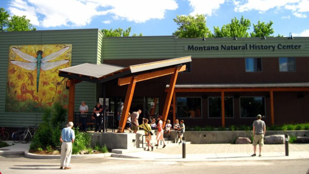
Montana Natural History Center Ice Age Floods National Geologic Trail The mission of the Montana Natural History Center is to promote and cultivate the appreciation, understanding, and stewardship of nature through education. Founded in 1991, MNHC was the brainchild of a group of educators who were involved in various efforts to educate both kids and adults about the natural history of western Montana, and who decided to unite those efforts into one environmental education organization. MNHC provides nature education programming for people of all ages through summer camps, kids’ activities, Visiting Naturalist in the Schools, Master Naturalist certification courses and Field Days, evening programs, Field Notes on Montana Public Radio, museum tours, and more. We have a variety of exhibits that focus on the flora, fauna, geology, and ecology of our beautiful state. Please stop by and visit! MNHC often partners with the Ice Age Floods Institute to share fields trips and lectures about the Ice Age Floods. MNHC has exhibits that help visitors explore the Glacial Lake Missoula and Ice Age Floods. Learn more at:Explore Glacial Lake Missoula | Montana Natural History Center (montananaturalist.org) The Glacial Lake Missoula Chapeter of the Ice Age Floods Institue also produced a short movie about Glacial Lake Missoula. You can find a link here. Quick Facts Location:120 Hickory Street, Suite A, Missoula, Montana
Lake Pend Oreille

Lake Pend Oreille Ice Age Floods National Geologic Trail The Purcell Lobe of the Cordilleran Ice Sheet repeatedly formed a 2000′ tall ice dam in this area, which backed up Glacial Lake Missoula and eventually burst catastrophically, releasing Ice Age Floods as often as about every ~10-60 years. Lake Pend Oreille is the largest lake in Idaho. The lake level is 2062 ft above sea level, with the surrounding terrain as high as 6002 ft. With a maximum depth of 1150 ft, this lake is the 5th deepest in the US. The location of the lake is probably related to an old river valley controlled by faults. The Lake Pend Oreille basin was carved by the repeated advances of Pleistocene ice and scoured by Ice Age Floods. With the waning of flood waters, the basin was filled with glacial out-wash and flood deposits. The lake is dammed at the south end by thick glacial and flood deposits that mark the beginning of the “Outburst Deposits”Quick Facts MANAGED BY:US Forest Service
Eddy Narrows

Eddy Narrows Ice Age Floods National Geologic Trail Eddy Narrows is a 10-mile long canyon between Plains and Thompson Fall along the Clark Fork River. Here all of the waters from the northern and eastern arms of Glacial Lake Missoula converged and picked up speed as they were forced through this restricted area. The steep valley walls are bare of talus and soils up to the level estimated to be the highest level of the lake (1000 ft), and there are polished grooves in the bedrock on a bench 340-400 feet above the Clark Fork River that run parallel to it. Since there is no evidence of glaciation in this area, the only explanation is the rapid draining of Glacial Lake Missoula. Using the dimensions of this flume-shaped area of the canyon, which controlled the rate of flow of water surging through it, in 1942 J.T. Pardee was able to calculate maximum speeds approaching 80 mph, emptying Glacial Lake Missoula in as little as three days. There are pullouts along MT-200 at either end of the narrowest part of this section marked for observing big horn sheep with Glacial Lake Missoula signage at the one between mileposts 59 and 60 at: 47.537940, -115.071654 Quick Facts Location:Between Plains and Thompson Falls, MT