Ice Age Floods National Geologic Trail Logo
After several years of coordination…Dan Foster, Ice Age Floods National Geologic Trail (IAF-NGT) Superintendent, announced we have a finalized version logo for the IAF-NGT that has been accepted and that will be displayed prominently throughout the floods area. WA-DNR’s graphic designer came up with the design that the Logo Committee believes best captures the essence of the meaning behind this national trail. During this process they faced a difficult task to capture something that was abstract, expressed itself visually in many different ways to represent the flood area, and reflected a story that is generally not well known to the public…now comes the work to sign the 4-state trail. Dan plans on sending out guidance to all the Trail partners on the proper use of the logo. Work is currently underway to develop a “Signing the Trail Plan”. This plan will give us a fairly accurate number for how many logo signs will be needed throughout the floods area. Until now we have only had a very rough guess. Having a more accurate figure for the number of logo signs that will be needed will give us a more accurate cost for making the signs and posts. It will also help the State DOT’s determine what it will cost them to install the logo signs and posts. Dan Foster has started people working on this and hopes to have the plan done this spring. They still have lots of unanswered questions about this process (i.e. how to pay for manufacturing and installing the logo posts) but to finally have a logo was the necessary first step. We started with several conceptual drawings from members of the logo committee and colleagues, but ended up using the services of a number of talented designers whose time was donated by their agency. During this process, a vast number of logos were drafted, but not chosen. Through this we learned the logic, recognition and cognitive association of a logo with its object. We appreciate all who worked on this and couldn’t have done it without them. Because of the difficulty in portraying the scientific nature of the trail, we spent considerable time focusing on designing a literal geologic translation of Ice Age Floods. However, what seemed to work in one place didn’t in another. What worked for instantaneous public recognition didn’t reflect the geologic accuracy this approach demanded. It took time for us to shift our point of view, but we were convinced when graphics designer Dan Coe with Washington Department of Natural Resources tried something different and it resonated with us. The adopted design is a contemporary scene that reflects the primary public purpose of the Trail as stated in its establishing legislation, to enable “the public to view, experience, and learn about the features and story of the Ice Age floods…” I think this approach communicates that there is something incredible to see and experience as one travels along the route, something that is consistent with the overall interpretive goal and approach of the Trail. While there may not be 100% concurrence for the logo from everyone, we think the logo to be distinctive enough that the public will be able to easily distinguish it from the many other trail logos in our Region. More importantly, we believe the logo captures the essence of the landscape that J. Harlan Bretz saw and used as the basis for first recognizing the former Ice Age Floods. The effort on the logo is symbolic of the entire trail partnership. We have an immense story with lots of players and opinions to disseminate it. Tasks ahead of us will also take time to reach consensus, but that consensus will be the strength of the trail moving forward over the coming years, even as we all come and go in our various roles.
Ice Age Flood Animation
This 3:50 minute animation, presented by the Crown Point Country Historical Society, illustrates the growth of the Cordilleran Ice Sheet, the damming and back-up of Glacial Lake Missoula, and the progress of an Ice Age Flood through WA and OR after an ice dam collapse.
Ice Age Floods National Geologic Trail (IAF-NGT) News
Dan Foster, Superintendent of Lake Roosevelt National Recreation Area (IAF-NGT administrative center for the National Parks Service (NPS)) admits that there’s little on the ground to show for the trail, but there’s still been quite a bit of organizational progress on the trail lately: Despite there being NO direct NPS funding for the trail, administrative funding squeezed out of the Lake Roosevelt National Recreation Area budget has kept things moving forward, Two required documents, the Foundation Statement and Long Range Interpretive Plan, are both complete, NPS.gov/IAFL, the official website for the trail, has been launched (note the last letter is an ‘L’), The critical step of deciding on a logo continues to be a sticking point for various reasons, predominantly related to design complexity, but the end of this year has been targeted to have it completed. When the logo is finalized a next big step is to begin signage to identify the large number of major and minor routes and features included within the IAF-NGT. With no NPS funds allocated for this, Dan estimates a need for $300,000 in matching funds to pay for the initial round of route signage. There will also be need for interpretive signage at key locations along the trail. There will be huge opportunities for individuals, businesses and agencies to contribute substantially to the development of the IAF-NGT. We encourage all of you to begin thinking and working now to identify and educate funding sources about these opportunities to encourage education and tourism throughout the IAF-NGT region. Do you have contacts with resources that could contribute to a project for the IAF-NGT? Would you be willing to work on a project to help develop the trail? These projects could be through the NPS, the IAFI, state and local organizations, or even our local chapter, to help develop and promote the IAF-NGT, such as: Roadside signage all along the IAF-NGT route, Interpretive displays at selected locations, Interpretive brochures, podcasts, videos, etc. “Fam Tours” for travel professionals, Other ideas you may have. If you want to help with the development of the IAF-NGT please contact us at IAFInstitute@gmail.com.
Williams Lake Cataract Video
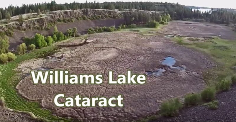
Williams Lake Cataract is an ancient, dry waterfall left behind along the Cheney-Palouse Scabland Tract in eastern Washington after Ice Age flooding recessionally ripped out underlying basalt to produce this massive cataract. Video produced by Bruce Bjornstad, Ice Age Floodscapes
Stev Ominski Prints Now Available in IAFI Store
Can you imagine the catastrophic scenes along the path of the Ice Age Floods? Stev Ominski is a very talented artist who has produced an exciting collection of works depicting what the Ice Age Floods might have looked like at several key locations along the paths of the floods. Prints of several of these artworks, signed by Stev himself, are now available through the IAFI Store. “Beginning of the End” – The artist describes this as “a study of several ways in which the ice dam may have begun to fail.” The scene overlooks the terminus of the ice dam, and depicts two small streams of water beginning to flow from the dam, shortly before the cataclysmic failure of the entire structure. “The Rowena Incident” – “An imaginary event based on two facts; one: that the approaching waters in the scene backed up behind Rowena Gap (another narrowing), and two: numerous Columbia Mammoth dig sites have been found nearby (within a mile or so of the present day site of the Columbia Gorge Discovery Center in The Dalles.” The Ice Age Floods Institute chose this print as the frontispiece of its last general brochure. In the scene, the viewer sees a small family of panicked mammoths flee from the rising floodwaters continuing to gush downstream from Wallula Gap at the same time as they were being backed up by the constriction of the gorge at Rowena Gap. This print measures 10 1/4 inches wide and 9 1/2 inches high, is mounted on a white backer and encased in a clear sleeve, with finished measurements of 16 1/4 inches wide and 12 1/4 inches high. “Inundation at Beacon Rock” – “The approaching flood waters slam into the side of Beacon Rock, in the central Columbia River Gorge. As this is a wide section of the gorge. The waters never topped Beacon Rock.” The view depicts the scene looking north across the Columbia River from its south bank. The print itself measures 17 inches wide and 11 inches high, is mounted on a white backer and protected by a clear sleeve, with total measurements of 22 1/4 inches wide and 15 1/4 inches high. “Age’s End” – The artist’s rendition of one of the Ice Age Floods crashing through the Columbia River Gorge. The view is looking east from the Women’s Forum, east of Portland, with Crown Point in the foreground and Beacon Rock barely visible in the background. The print itself measures 17 inches wide and 11 inches high, and is mounted on a white backer and protected in a clear sleeve, with finished dimensions of 22 1/4 inches wide and 15 1/4 inches high. “The Bellevue Erratic” – This erratic (a van-sized piece of Belt Rock/Schist) sits today as the largest found in the Willamette Valley. The print itself measures 17 inches wide and 11 inches high, is mounted on a white backer and encased in a clear protective sleeve, with finished measurements of 22 1/4 wide and 15 1/4 high. “The Deluge” – Depicts Palouse Falls as it looked with diminishing floodwaters rushing down the Palouse River Canyon. This print measures 11 inches wide and 17 inches high, is mounted on a white backer and encased in a clear sleeve, giving final measurements of 15 1/4 inches wide and 22 1/4 inches high. This picture, though beautiful by itself, is a natural companion to another available art print “Palouse” which depicts Palouse Falls today. “Palouse” – Although immersing himself in flood studies, Stev couldn’t resist painting beautiful Palouse Falls as they appear today and making the print available to the public. This print is sold by itself, but makes a lovely companion to “Deluge”, which depicts the same site as it might have appeared with torrents of water raging down the Palouse Canyon to the Snake River. “Palouse” measures 11 inches wide and 17 inches tall, is mounted on a white backer, encased in a clear sleeve, and has finished measurements of 15 1/4 inches wide and 22 1/4. inches high.
The Great Blade – Bruce Bjornstad Video
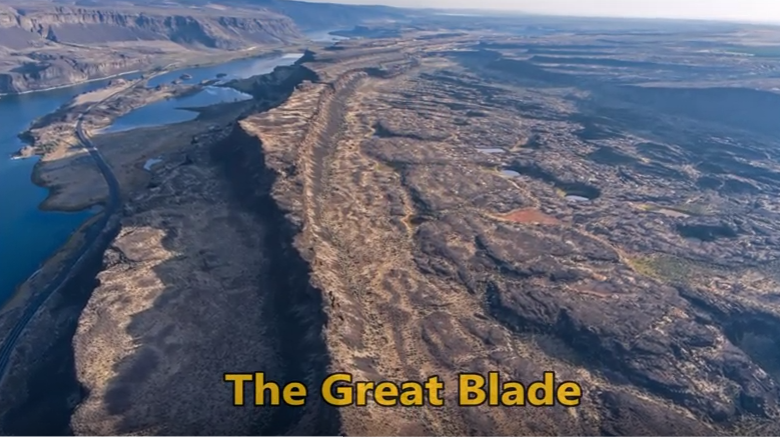
“…there were a few double falls each member of which receded at approximately the same rate, so that the island in mid-channel became very much elongated, like a great blade, as the falls receded and the canyons lengthened.” J Harlen Bretz (1928) A tall, narrow basalt ridge, coined “The Great Blade” by J Harlen Bretz, parallels Lower Grand Coulee east of Lake Lenore. The blade is the product of Ice Age floods that repeatedly rampaged Grand Coulee as recently as 15,000 years ago. Most of the floods appear to have come from sudden outbursts from glacial Lake Missoula. During flooding the coulees on either side of the Great Blade were filled with up to 800 ft turbid water. The largest floods also overtopped the Great Blade, submerging the site under at least another 100 ft of floodwater. On the west side of the blade, where Lake Lenore is located, lies the Lower Grand Coulee, which ultimately migrated 10 miles northward – all the way to Dry Falls. On the east side of the blade is the higher East Lenore Coulee, which migrated a shorter distance (~3 mi) to Dry Coulee. Like a gigantic rib the Great Blade is tallest and narrowest at its south end, widening to the north. The blade extends for almost four miles from where the head of East Lenore Coulee intersects Dry Coulee. In places the blade narrows to as little as 800 ft wide. Video produced by Bruce Bjornstad for Ice Age Floodscapes
Lake Lewis Isles Tour
Lake Lewis Isles, Badger Mt. Centennial Preserve and Skyline Trail Best Observation Points By Auto: 1. Along State Route, SR 240 near mile posts 24-26, and along SR 224 and Interstate, I-82, in Richland and Kennewick, WA. 2. Along I-182 near Road 68 in Pasco, WA. Lake Lewis Isles Trails Off-road trails ascend Badger Mountain, Red Mountain and Goose Hill, located south and west of Richland, Washington. These and two other neighboring hills were mere islands that poked out above Lake Lewis when floodwaters backed up to over 1,200 feet in elevation behind Wallula Gap (Figure 1). Badger Mountain Trails Badger Mountain Centennial Preserve is owned and operated by Benton County of Washington State. It was created as the result of a grassroots campaign led by the Friends of Badger Mountain to preserve the mountain as public open space. The preserve is now home to five trails, accessed via two different trailheads, one at Trailhead Park, and one off Dallas Road (Figure 2). Trailhead Park Location: N 46.238404°; W 119.306286°, parking lot of Trailhead Park located at 525 Queensgate Dr., Richland, Washington. To access this trailhead take Exit 3A (Queensgate Drive South) off Interstate I-182 south of Richland, Washington. Proceed 0.5 miles and turn left (east) onto Keene Road. Proceed 0.6 miles east to Shockley Road (near Bethel Church) and turn right. Follow Shockley Road to the end, where you turn left on Queensgate Drive, and go up the hill to the stop sign, where you turn right on to White Bluffs St. and then turn left into the parking lot. Trail Length / Difficulty: From this trailhead hikers have their choice of three trails – Canyon Trail (1.3 miles / Moderate), Sagebrush Trail (0.6 miles / Easy to Moderate), or Badger Flats Trail (0.4 miles / Easy). Dallas Road Trail Head Location: N 46.242209°; W 119.342810°. To access this trailhead, take Exit 3B (Queensgate Drive North) off Interstate I-182 south of Richland, Washington. Proceed 0.2 miles and turn left (south) on to Duportail Street. Proceed approximately 0.7 miles and turn right (west) on to Keene Road. Proceed another 0.6 miles and turn left on Kennedy Road. Stay on Kennedy Road for 0.6 miles and turn left (south) onto Dallas Road. Follow Dallas Road for 1.2 miles, going under the I-182 overpass and continuing to the top of hill, then turn left onto a gravel road that takes you to the trailhead. Trail Length / Difficulty: From here hikers have their choice of the Skyline Trail (2.9 miles / Moderate), or Southside Trail (2.5 miles / Easy). Skyline Trail offers spectacular views of the Lake Lewis Isles. Warning: Outside of Trailhead Park there is no shade or portable water. Skyline Trail Description (after http://hiketricities.com/badger-mountain-dallas-road/) The trail winds and climbs gradually through virgin sagebrush. As you reach the top of the sagebrush field, you’ll cross over a dirt road that provides vehicles access to the communication towers on top of Badger Mountain. Across the road, you’ll get spectacular views of Candy Mountain and Red Mountain to the west, two of the Lake Lewis Isles. You will also get great views of the lower Yakima Valley, Richland, West Richland and the Hanford Site (a.k.a. Hanford Nuclear Reservation). Following a few switchbacks, you’ll continue climbing up the ridge. You’ll pass a granitic marker where geologists believe temporary Lake Lewis reached its maximum elevation, submerging the Tri-Cities with over 800 feet of water (Figure 1). Here you have a great view of Rattlesnake Mountain, the Hanford Site, and the Hanford Reach National Monument. Continuing up the mountain, you’ll hike through desert grasses, with plentiful wildflowers in early spring. As you reach the spine of the ridge, you’ll again cross the dirt access road. At this point you have a view of the Horse Heaven Hills and Badger Canyon and as well as the lower Yakima Valley. The trail winds around the south or “back” side of Badger Mountain, passing a couple of communication towers, and then splits. Follow the left fork. The right fork will take you back down to Trailhead Park via the Sagebrush Trail. Follow the trail up to the tower and enjoy the view! On a clear day, you can see the Blue Mountains to the east along with the Tri-Cities, Columbia and Yakima Rivers, Hanford and Badger Canyon. On a clear day, you may get a glimpse of Mt. Adams, over 100 miles to the west. You can either retrace your steps or follow the dirt road back to where the upper trail crosses and then take the trail back down. Taken, in part, from On the Trail of the Ice Age Floods by Bruce Bjornstad1 and the hiketricities.com website. Bjornstad, B. N. 2006. On the Trail of the Ice Age Floods: A geological field guide to the Mid-Columbia Basin. Keokee Books, Sandpoint, Idaho.
George Last – President (Renewed) of Lake Lewis Chapter
George Last was recently elected president of the Lake Lewis Chapter. Many of you who have been in IAFI a long time will remember that George was the chapter president for 10 years. After a break of a few years he is again chapter president. We are pleased to have him as an IAFI Director again. Gary Kleinknecht is especially pleased to have George as chapter president as this will permit Gary to spend more time at the dig and conducting field trips. Gary will continue to be on our board as a Director and our vice president. George was one of the major people who developed the Lake Lewis chapter brochure and thus has detailed knowledge of the process. We will be asking George to provide guidance, as needed, to the other chapters on their brochure work. This should include the easiest way to get this work done as well as how are we going to get the maps done, which is a major hurdle we need to get over. We are confident with George’s guidance we can get this work done in the most efficient manner.
Did humans witness any megafloods?
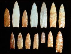
Richard Waitt kindly shared his recent paper published June 2016 in Quaternary Research, titled “Megafloods and Clovis cache at Wenatchee, WA.” “It covers the reach mainly from Chelan Falls to below West Bar, tries to tell the story of sequential megafloods coming to Wenatchee area by different routes at different times, and tries to work in the story of early Homo sapiens in the region, especially as contemplated from the 1988-1990 excavations of the East Wenatchee Clovis cache,” said Waitt in an email to the Wenatchee Valley Erratics. His easy-to-read and immensely interesting paper covers both the geological and the archaeological stories for the Wenatchee area. Did humans witness megafloods? Read the paper Megafloods and Clovis cache at Wenatchee, Washington to find out!
CWU’s Geology of Washington Course: Free
People of all ages and backgrounds are welcome and invited to attend any of these lectures free: Geology of Washington (GEOL 101 section 02) 10:00 – 10:50 am MTRF (no lectures on Wednesdays) CWU’s new Science II building – room 103 Fall Quarter Sept 22 – Dec 6, 2016 Instructor: Nick Zentner This is the 15th quarter we’ve had a handful of “townies” in addition to the CWU students. Plenty of room for you and friends. For the “townies”…we’re real casual. No registration, no auditing, no reserving seats, etc. Come whenever you’re in the mood. Take the whole class or just a few lectures. Free parking is handy just north of Memorial Park on E. 7th Avenue. The new Science II Building (Geology & Physics) – room 103 – is just a couple of buildings north of Lind Hall (our old home). See attached map. Our first class is Thursday, Sept 22 at 10:00 am.