2018 Annual IAFI Field Trip – Lower Columbia Chapter
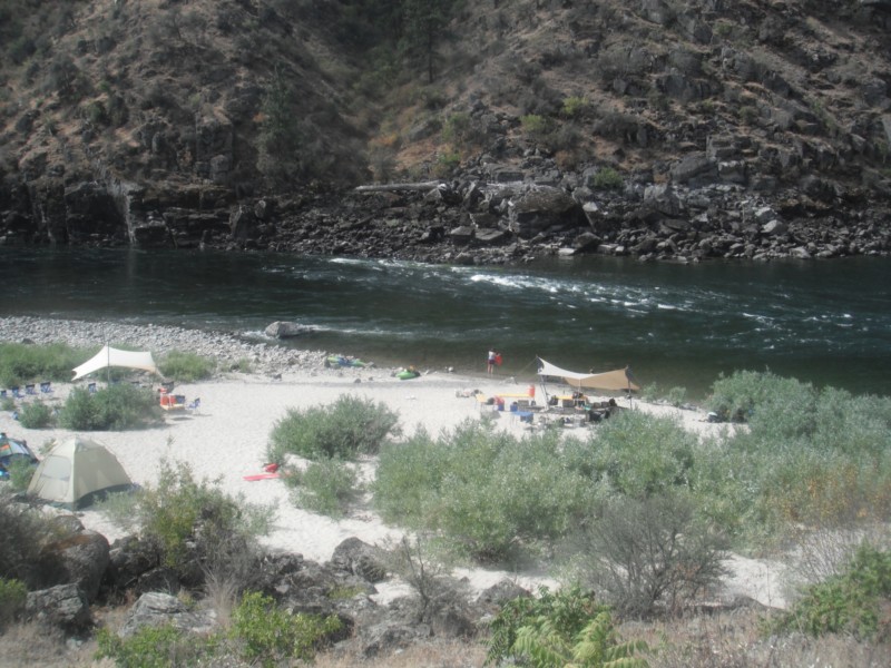
We started our field trip at the Tualatin library where the bones of a number of ice age mega-fauna are on display. Yvonne Addington led us through the displays and explained some of her role in arranging to have the bones in Tualatin where they were found. After the library we took a stroll on the Tualatin River Greenway Trail where we were instructed by several members of the Rivers of Life Youth Tourism Corp. who volunteered to be docents on the trail. We viewed signs, erratic boulders, casts of the mega-fauna and granite insets with maps and timelines. This $3.8 million trail was put in a couple years ago as part of Tualatin’s ice age identity as well as the $230,000 bronze statue of a young mastodon and a stylized image of the boy who dug it up only about a mile from where the bronze is today. Most of the actual skeleton of the mastodon is now on display in the library. After viewing the statue we went to the neighboring town of West Linn. At Fields Bridge Park we walked the nature trail with its three kiosks revealing the story of the ice age floods and the Willamette Meteorite that landed not far from there when the iceberg it was carried in was grounded on the hillside. From Fields Bridge Park we traveled east on Willamette Falls Drive over the gravel bar that the town of Willamette was built on. We then stopped at the I-205 overlook to see Willamette Falls. This Falls is the second largest in the United States by volume after Niagara Falls. Since this has been a fairly dry year it was easy to see the basalt rocks that the river cascades over. After lunch at Tualatin Community Park we took a short drive to the Tualatin Heritage Center; home of the Tualatin History Society. It is here where the molar and tusk from the Tualatin mastodon is housed as well as a collection of ice rafted boulders from the surrounding area. Yvonne Addington, former president of the Tualatin Historical Society, described the display of news articles, photographs and book covers telling the story of the Center and the ice age features. Our next stop, the Tualatin Commons, has a man-made lake with undulating hand-railing representing the wave action of the Ice Age floods and glass drinking fountains representing icebergs in those floods along with several ice rafted boulders; one being an argillite. Partly for fun and partly to see how a community can capitalize on an ice age idea we went to Ibach Park with its symbolic ice age floods play structures. The spongy blue pavement represented the water; some of it including ripples with icebergs. In the sand area children can dig for replica fossils and with the water feature they are able to make their own ice age floods through a collection of ice rafted erratics. We viewed the sign that for the last 20 years has been telling people about the ice age floods, the Willamette Meteorite, the mastodon and the local history. This award-winning park and its structures and signage was years ahead of other areas in adopting the ice age floods theme. Click here to view the full article with many more pictures. Between the towns of Tualatin and Sherwood there is a series of ice age flood channels that funneled the water from the Tualatin Valley into the Willamette Valley. This area is called the Tonquin Scablands. We stopped to view an erosional remnant of two basalt flows separated by a soil horizon and Coffee Lake, a kolk lake, created when two flood channels converged and formed a vortex that removed rock and soil leaving what is now a coffee-colored lake. We then drove along the largest of the 14 Tonquin Flood Channels to an area where we could get out and view that channel both north and south.
Ice Age Features in Shallow Waters
Many of the features left behind by the ice age floods are not apparent to the average visitor to areas where the floods were relatively shallow, such as the Bitterroot River valley south of Missoula, Montana. The Bitterroot Valley has erratics and subtle strandlines in several locations. J.T. Pardee, the Montana geologist who in the early 1900’s identified the source of the water for Bretz’s flood, published a paper and sketches specifically about the Bitterroot valley, where he was living at the time. These features can be used to tell the Ice Age Floods story if put together in a useable format. That is just what happened this summer when Jessica Dufresne, a local elementary school librarian, was selected to develop a curriculum aimed at 4th-8th grades under the National Park Service’s Teacher Ranger Teacher program. The program is aimed at linking to lesser known park units such as the Ice Age Floods National Geographic Trail to underserved student populations and offers professionals the opportunity to learn about the resources and educational materials available through the National Park Service. Dufresne, daughter of Glacial Lake Missoula chapter vice president Lynne Dickman, grew up with geology and always found it interesting. Now she can share that enthusiasm with other teachers and young learners. Other partners in the grant were the Montana Natural History Center and the Bitterroot Cultural Heritage trust. The Glacial Lake Missoula chapter also assisted in locating these features and plans to add them to its field trips and its map and guide.
Boulderstrewn – Bretz’s Historical Home
“Boulderstrewn” is the home J Harlen Bretz built in the Chicago suburbs in the 1920’s and died in on his 98th birthday. Much of Bretz is still there, and since purchasing Boulderstrewn over 10 years ago the current owner has toiled to resurrect Bretz’s presence on the property. The owner created a rock garden of many specimens that remain on the property, which had been slowly getting buried. Many monuments Bretz built are still there – a travertine bird bath, a sandstone sundial and a concretion on a pedestal. Inside the house, besides an updated kitchen, it’s very much the same as during the time of Bretz and Fanny. The basement features Bretz’s still usable cold shower (no hot water just as Bretz liked it) and soap dish (though someone painted the shower white). Bretz’ secret wine cellar room is also still there, though the gate and intricate lock system is gone. Little remnants of his boobytraps are everywhere, as well as old bottles from his winemaking days and a few license plates. The Garden Cabin with a beautiful stone fireplace he built in the back of the yard for Fanny to do her art is still there, recently fully restored and rescued from sinking into the ground. As you can see in the photos on the AirBnB site the property appears to be in impeccable shape. The current owner, Peter Doran, no longer lives in the area and is unable to continue supporting the house expenses. So he is considering options from AirBnB to selling the property, and is receptive to interest and other suggestions. If anyone has, or knows of someone who has an interest in or ideas for preserving this bit of Bretz’s historical legacy please get in touch with him at peter.t.doran@gmail.com.
Ice Age Floods: A Journey of Awakening – Susan Langsley
Do you ever hear the Led Zepplin song “Kashmir” in your head when contemplating the Ice Age Floods? “I am a traveler of both time and space. To be where I have been” –Robert Plant, Led Zepplin’s Kashmir My 11-year old daughter and I are on a 5-day, 4-night raft trip on the Lower Salmon river and we are having the time of our lives! Sun, sand, water, lovely food, games and some of the finest nicest Eastern Oregonians we have ever met. One of the guides is a sensitive and strapping young man who is a student at U of Oregon. He’s both an English major and a Geology major. What do you with that? You write about the soul of the earth, true love and adventure, river stories, deep thoughts that cross scientific paradigms. I see him becoming a teacher someday, maybe a science teacher like his Dad. And he’s a kayaker like me. What is so amazing about the Eastern Oregon guides is their familiarity with, connection to, and love of the river and land. They don’t fight traffic or get on the morning commute treadmill every day. There are no stoplights in the whole of Wallowa County, and the only food franchise is a Subway sandwich shop, no Costco or Walmart. Sure, they have school and work, but they are connected to and love the land they live on in deeper ways that us city folks miss. They are here to tell us about the land. They are guides. The 4th day on the river we pass a group of pillar-like rocks with beautiful symmetry. “That’s columnar basalt” my guide says, “The geologist who figured out the floods and travelled around these parts was J Harlan Bretz”. “J Harlan Bretz” I repeat, carefully, committing to memory. When I returned home to talk to my friend (who was a geology major at Wesleyan) about the trip, she replies “’J Harlan Bretz,’ Oh yes, I have all his books!” An Amazon search and I begin by reading a biography of J Harlan Bretz, “Bretz’s Flood” by John Soennichsen- (some guy from Eastern Washington… hmmm). And guess what: It’s so well-written, I can’t put it down! I am enthralled cover-to-cover with the character of J Harlan Bretz, his teaching method of taking students to the field (and floating them downstream on large Sequoia logs, upon occasion), his love of life, the serendipity of his study of the USGS Quincy Basin topo map when it first published, many summers spent driving around and measuring the Channeled Scablands, presenting his field evidence and theories at the Cosmos Club in Washington DC, and most of all his ability to KNOW he was RIGHT when all his colleagues scoffed and dismissed his theories. Now THAT man was a pillar of strength. Perhaps like a column of basalt? If he were alive today, Harlan Bretz could stand up to money-motivated physicians – the bad kind, nepotism in the school district, gossipers and bullies, and other types of corruption, all of which I have had to do to defend my younger child against since. J Harlan Bretz helped me to do this. He was a GREAT man! “All I see turns to brown.. And fills my eyes with sand as I try not see the wasted land” – Kashmir by Led Zepplin What was it about those floods, biblical in nature, that left behind a story of such jaw-dropping inspiration? Who are these people who live in Eastern Oregon and Washington and are so inspired by the landscapes there they are called to find new ways to study it, publish, write fantastic biographies? I continued my search to find other scholars of the Ice Age Floods, and that led me next to Nick Zentner and Bruce Bjornstadt. To be continued…
Could a Glacial Outburst Flood Repeat the “Younger Dryas” Cooling Event?
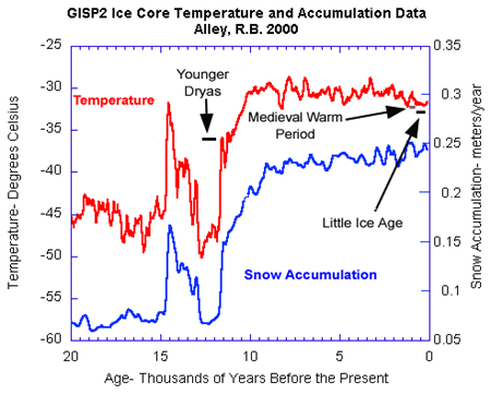
An ancient flood seems to have stalled the circulation of the oceans, plunging the Northern Hemisphere into a millennium of near-glacial conditions. Thirteen thousand years ago, an ice age was ending, the Earth was warming, the oceans were rising. Then something strange happened – the Northern Hemisphere suddenly became much colder, and stayed that way for more than a thousand years. For some time, scientists have been debating how this major climatic event – called the “Younger Dryas” – happened. The question has grown more urgent: Its answer may involve the kind of fast-moving climate event that could occur again. This week, a scientific team made a new claim to having found that answer. On the basis of measurements taken off the northern coasts of Alaska and Canada in the Beaufort Sea, the scientists say they detected the signature of a huge glacial flood event that occurred around the same time. This flood, they posit, would have flowed from the Arctic into the Atlantic Ocean and shut down the crucial circulation known as the “Atlantic meridional overturning circulation” (or AMOC) – plunging Europe and much of North America back into cold conditions. “Even though we were in an overall warming period, this freshwater, exported from the Arctic, slowed down the vigor, efficiency of the meridional overturning, and potentially caused the cooling observed strongly in Europe,” said Neal Driscoll, one of the study’s authors and a professor at the Scripps Institution of Oceanography. The work, published in Nature Geoscience, was led by Lloyd Keigwin of the Woods Hole Oceanographic Institution along with researchers at that institution, Scripps and Oregon State University. The result remains contested, though, with other researchers still arguing for different theories of what caused the Younger Dryas – including a very differently routed flood event that would have entered the ocean thousands of miles away. Nonetheless, the story is relevant because today, we’re watching another – or rather, a further – deglaciation, as humans cause a warming of the planet. There is also evidence that the Atlantic circulation is weakening again, although scientists certainly do not think a total shut-off is imminent, and are still debating the causes of what is being observed. Either way, the new research underscores that as the Earth warms and its ice melts, major changes can happen in the oceans. And could happen again. The researchers behind the current study, working on board the U.S. Coast Guard Cutter Healy, analyzed sediments of deep ocean mud, which contain the shells of long-dead marine organisms called foraminifera. In those shells, the scientists detected a long-sought-after anomaly recorded in the language of oxygen atoms. The shells contained a disproportionate volume of oxygen−16, a lighter form (or isotope) of the element that is found in high levels in glaciers. That is because oxygen−16, containing two fewer neutrons and therefore lighter than oxygen−18, evaporates more easily from the ocean but does not rain out again as readily. As a result, it often falls as snow at high latitudes and is stored in large bodies of ice. “This is the smoking gun for fingerprinting glacial lake outbursts,” Driscoll said. And that means the findings may also represent the trigger for the Younger Dryas. The thinking is that as the ice age ended and the enormous Laurentide ice sheet atop North America began to retreat, the resulting meltwater fed a bevy of large lakes atop the depressed surface of the continent. That included the massive glacial Lake Agassiz, which stretched from the Great Lakes northwestward across much of Canada. The approximate maximum extents of major glacial lakes that formed from the retreat of the western Laurentide Ice Sheet. (Shannon Klotsko, Scripps Institution of Oceanography, University of California at San Diego) Prior research had shown that for a while, much of the resulting freshwater drained down the Mississippi River and into the Gulf of Mexico. But at some point, as the ice sheet continued to shrink, the flow of water appears to have been suddenly rerouted to the north or to the east, where it could do more potential damage to the ocean circulation in the Atlantic. There has long been scientific debate about where all the meltwater actually entered the ocean, though – with some contending that it would have occurred through the St. Lawrence River, which flows past today’s Montreal and Quebec City and thus out into the Atlantic. The new research holds that, instead, the floodwater exited through the Mackenzie River, which stretches across today’s Northwest Territories, emptying straight into the Arctic Ocean. It would certainly have been an enormous flow of fresh water. “I would say somewhere between the Mississippi and the Amazon,” Keigwin said. That could have interfered with the Atlantic circulation, which is crucial because it carries warm water northward, and so heats higher latitudes. Eventually, the waters of the circulation become very cold as they travel northward, but because they are also quite salty, they sink because of their high density and travel back south again. Freshening is therefore the Achilles’ heel of the circulation. And the new study argues that although the glacial water would have entered the seas very far away near the present Alaska-Canada border, it would have then circulated around the Arctic, eventually traveling south past Greenland and entering the key regions that are crucial to the overturning circulation, which tend to be off Greenland’s southern coasts. Not everyone is convinced, though – including some researchers who have previously published results suggesting that the outburst flood or flow was instead to the east, through the St. Lawrence River. “They have produced a nice signal of the release of freshwater into the Arctic Ocean, but the conclusions are based on an uncertain chronology which, when trying to tie together events so closely, requires some independent confirmation,” Peter Clark, an Oregon State University geoscientist who has published evidence supporting the St. Lawrence River theory, said in an email. Anders Carlson, Clark’s co-author and colleague at Oregon State University, sent a geological study finding that, as he put
First People in the Americas – When? How?
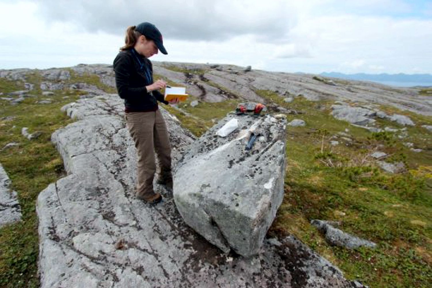
When and how did the first people come to the Americas? The conventional story says that the earliest settlers came via Siberia, crossing the now-defunct Bering land bridge on foot and trekking through Canada when an ice-free corridor opened up between massive ice sheets toward the end of the last ice age. But with recent archaeological evidence casting doubt on this thinking, scientists are seeking new explanations. One dominant, new theory: The first Americans took a coastal route along Alaska’s Pacific border to enter the continent. A new geological study provides compelling evidence to support this hypothesis. By analyzing boulders and bedrock, a research team led by the University at Buffalo shows that part of a coastal migration route became accessible to humans 17,000 years ago. During this period, ancient glaciers receded, exposing islands of southern Alaska’s Alexander Archipelago to air and sun — and, possibly, to human migration. The timing of these events is key: Recent genetic and archaeological estimates suggest that settlers may have begun traveling deeper into the Americas some 16,000 years ago, soon after the coastal gateway opened up. The research will be published online on May 30 in the journal Science Advances. “People are fascinated by these questions of where they come from and how they got there,” says lead scientist Jason Briner, PhD, professor of geology in UB’s College of Arts and Sciences. “Our research contributes to the debate about how humans came to the Americas. It’s potentially adding to what we know about our ancestry and how we colonized our planet.” “Our study provides some of the first geologic evidence that a coastal migration route was available for early humans as they colonized the New World,” says UB geology PhD candidate Alia Lesnek, the study’s first author. “There was a coastal route available, and the appearance of this newly ice-free terrain may have spurred early humans to migrate southward.” The findings do not mean that early settlers definitely traversed Alaska’s southern coast to spread into the Americas: The project examined just one section of the coast, and scientists would need to study multiple locations up and down the coastline to draw firmer conclusions. Still, the work is exciting because it hints that the seafaring theory of migration is viable. The bones of an ancient ringed seal — previously discovered in a nearby cave by other researchers — provide further, tantalizing clues. They hint that the area was capable of supporting human life at the time that early settlers may have been passing through, Briner says. The new study calculates that the seal bones are about 17,000 years old. This indicates that the region was ecologically vibrant soon after the ice retreated, with resources including food becoming available. Co-authors on the research included Briner; Lesnek; Charlotte Lindqvist, PhD, an associate professor of biological sciences at UB and a visiting associate professor at Nanyang Technological University; James Baichtal of Tongass National Forest; and Timothy Heaton, PhD, of the University of South Dakota. A landscape, touched by ice, that tells a story To conduct their study, the scientists journeyed to four islands within the Alexander Archipelago that lie about 200 miles south/southeast of Juneau. The team traveled by helicopter to reach these remote destinations. As soon as the researchers arrived, Briner knew that the islands had once been covered by ice. “The landscape is glacial,” he says. “The rock surfaces are smooth and scratched from when the ice moved over it, and there are erratic boulders everywhere. When you are a geologist, it hits you in the face. You know it immediately: The glacier was here.” To pinpoint when the ice receded from the region, the team collected bits of rock from the surfaces of boulders and bedrock. Later, the scientists ran tests to figure out how long the samples — and thus the islands as a whole — had been free of ice. The researchers used a method called surface exposure dating. As Lesnek explains, “When land is covered by a glacier, the bedrock in the area is hidden under ice. As soon as the ice disappears, however, the bedrock is exposed to cosmic radiation from space, which causes it to accumulate certain chemicals on their surface. The longer the surface has been exposed, the more of these chemicals you get. By testing for these chemicals, we were able to determine when our rock surfaces were exposed, which tells us when the ice retreated. “We use the same dating method for huge boulders called erratics. These are big rocks that are plucked from the Earth and carried to new locations by glaciers, which actually consist of moving ice. When glaciers melt and disappear from a specific region, they leave these erratics behind, and surface exposure dating can tell us when the ice retreated.” For the region that was studied, this happened roughly 17,000 years ago. The case for a coastal migration route In recent years, evidence has mounted against the conventional thinking that humans populated North America by taking an inland route through Canada. To do so, they would have needed to walk through a narrow, ice-free ribbon of terrain that appeared when two major ice sheets started to separate. But recent research suggests that while this path may have opened up more than 14,000 years ago, it did not develop enough biological diversity to support human life until about 13,000 years ago, Briner says. That clashes with archaeological findings that suggest humans were already living in Chile about 15,000 years ago or more and in Florida 14,500 years ago. The coastal migration theory provides an alternative narrative, and the new study may mark a step toward solving the mystery of how humans came to the Americas. “Where we looked at it, the coastal route was not only open — it opened at just the right time,” Lindqvist says. “The timing coincides almost exactly with the time in human history that the migration into the Americas is thought to have occurred.” The research was
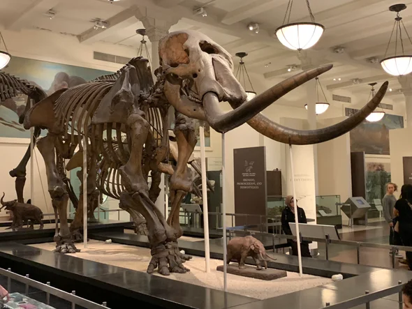
Uncovering a Columbian Mammoth
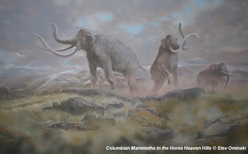
There’s a Columbian Mammoth hiding out in Coyote Canyon down Kennewick way, and MCBONES Research Center Foundation is working to uncover his/her hiding place. For a small contribution you can tour this hide-and-seek site, or you can volunteer to help uncover the hidden mammoth. Sound interesting? Find out more in this short video produced by Mark Harper of “Smart Shoot“, or visit the MCBONES website. The Mid-Columbia Basin Old Natural Education Sciences (MCBONES) Research Center Foundation provides local K-12 teachers and their students, as well as other volunteers, an opportunity to actively participate in laboratory and field-based research in paleontology, geology, paleoecology, and other natural sciences primarily within the Mid-Columbia Region of southeast Washington State.
Global Human Migration Paths and Timing
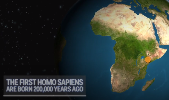
There is considerable controversy regarding when humans first migrated into the Americas and whether they might have been in the local area during any of the Ice Age Floods. This 2016 video, produced by reputable sources, doesn’t answer that question, but it is an interesting and instructive visualization of human migration paths and timing over the past 200,000 years.
IAFI – GuideStar Bronze
Ice Age Floods Institute was recently recognized for our transparency with a 2018 Bronze Seal on our GuideStar Nonprofit Profile! GuideStar is the world’s largest source of information on nonprofit organizations. More than 8 million visitors per year and a network of 200+ partners use GuideStar data to grow support for nonprofits. In order to get the 2018 Bronze Seal, Ice Age Floods Institute shared important information with the public using our profile on GuideStar. Now our community members and potential donors can find out more about our mission and programs. Check out our GuideStar Nonprofit Profile and tell us what you think.
The Cerutti Mastodon Site – A Bretz Type Controversy of Our Time
In March, while visiting San Diego, I went to the San Diego Museum of Natural History in Balboa Park and toured the remarkable Cerutti Mastodon Site exhibit. This controversial exhibit of a mastodon site is notable for its claim that the mastodon’s bones were broken by humans 130,000 years ago, making it far older than any other such site in North America. The signs at the beginning of the exhibit read as follows; “The Cerutti Mastodon discovery. A San Diego find reveals the earliest evidence of of human life in North America. In 1992, paleontologists from the San Diego Natural History Museum were surveying a highway construction site to identify and salvage any fossils that might be unearthed. “Field paleontologist Richard Cerutti spotted some bones and tusks. Exploring further, the team discovered that these were bones of a mastodon-an extinct relative of elephants. “But Richard noticed something unusual. The bones were mysteriously broken and the pieces separated. “It took 22 years for scientists to solve the riddle. Once they did, they realized that this local site is evidence of human presence on this continent 130,000 years ago-much earlier than we thought possible. “In 2014, scientists made a new discovery about the age of the Cerutti Mastodon Site. How did this happen? Scientists figured out the age of the mastodon bones using radiometric dating. It’s a way of telling how old a rock or fossil is by measuring its radioactive isotopes. “A radioactive isotope transforms into an isotope of a different element over time. If you know the rate at which the “parent” isotope transforms into its “daughter” isotope, measuring the parent-daughter ratio tells you how old the material is. “Scientists used a method that measures the ratio of the radioactive isotope uranium-234 to its daughter isotope thorium-230. Dramatic improvements in this method have made it a highly accurate means of dating very old materials- up to 500,000 years. In 2014, scientists used this method to date bones at the Cerutti Mastodon Site. “The results were clear. The bones are approximately 130,000 years old.” More than two decades after the Cerutti mastodon’s discovery in southern California in 1993, USGS scientist Dr. James Paces was sent several bones of unknown age. The specimens were important because they came from a site with abundant evidence of processing by ancient humans. Advances in analytical capabilities and the understanding of processes that incorporate natural uranium and its decay products in fossil bone provided archaeologists with a radiometric dating tool that, at least in some cases, could confidently and accurately determine ages for these older materials. After analyzing nearly 100 subsamples from multiple specimens, Dr. Paces determined that the mastodon bones—which were still fresh when someone fractured them using hammerstones and rock anvils—were covered with sediments 131,000 years ago, give or take about 9,000 years. This result indicates that some form of archaic humans arrived in the Americas more than 100,000 years earlier than scientists had thought possible. Following the dating of the bones officials at the Natural History Museum began making plans for a permanent exhibit about the discovery. The exhibit opened in 2017. It is very thorough and includes bones, alleged hammerstones, and anvil rocks from the original mastodon site as well as numerous photos and interpretive panels. When J Harlen Bretz first announced in the 1920’s his theory that the scablands of eastern Washington State had been carved out by a cataclysmic flood he met stiff opposition. What he was proposing was so far out of the mainstream of geological thinking of the time that many scientists couldn’t accept it. Schooled in uniformitarianism they believed that earth’s landforms were all created by slow gradual processes operating over time and that an event of the magnitude Bretz was proposing just wasn’t possible. They tried to come up with alternative explanations for the facts Bretz presented that fit in with their current frame of reference. Yale University geologist Richard Foster Flint famously said of certain flood features in the scablands that they presented “a picture of leisurely streams with normal discharge.” The claim by San Diego’s Natural History Museum that the Cerutti site is 130,000 years old is likewise far outside what many scientists of our time are ready to accept. Other similar sites are much younger. For example Sequim’s famous mastodon site is only 13,800 years old. If the San Diego Natural History Museum is correct it totally rewrites the history books about humans in North America. It places humans in North America during a previous interglacial period. It would establish that humans had long since been in North America during the time of the comparatively recent ice-age floods. Critics of the Natural History Museum, and there are many, point to things like what they consider to be a lack of lithics from the site. Others speculate that the signs of bone breakage observed at the site may have been caused by some other creature besides humans or by modern day construction equipment. But the Natural History Museum counters that none of the critics have provided a satisfactory alternative explanation for the evidence that they’ve presented. Cerutti and his team of researchers and the San Diego Natural History Museum remain unequivocal in their conclusion: The Cerutti Mastodon Site is a 130,000 year old archaeological site. – by Mark Sundquist, Puget Lobe Chapter “Ideas without precedent are generally looked upon with disfavor and men are shocked if their conceptions of an orderly world are challenged.” J Harlen Bretz 1928 “Extraordinary claims require extraordinary evidence – each aspect requires the strongest scrutiny,” Chris Stringer