”Global Megaflood Science” Dr. Vic Baker
“Global Megaflood Science” – Dr. Victor R. Baker – Lower Columbia Chapter -Virtual Meeting Starting in the late 1960s, an accelerating pace of discovery has revealed that the last major de-glaciation of planet Earth involved a global pattern of huge outbursts of water from the margins of wasting continental ice sheets. Much of this water was delivered as relatively short-duration floods with peak flows comparable to those of ocean currents. The global inventory of these phenomena now includes about 4 dozen examples from Asia, Europe, North America, South America, and Iceland. Though there have been many advances in understanding the physical processes and geochronology of megaflooding, important controversies remain, including: the role of flooding on areas that are now under the oceans; the nature of subglacial megaflooding; and the details of the vast network of megaflood landscape features in Asia. Immense outburst floods likely induced very rapid, short-term effects on the global Earth environment. Recorded Thursday, July 16, 2020 at 7:00 PM
Glacial Lake Missoula – Inspired Classroom Videos

The Glacial Lake Missoula chapter has worked with Inspired Classroom LLC to produce a series of 9 short (3-7 minute) videos exploring different aspects of the Ice Age Floods in the Glacial Lake Missoula area. The entire set is posted to the Inspired Classroom LLC YouTube channel, including a full 31 minute version (below) that compiles the entire set.
Check with the Experts at Our New “Geology Corner”
Do you have a geology question? We might have an answer! Do you have a geologic fact to share? We have a way to do that! Members who want to do a short article, or describe a field trip location of interest, or describe some geologic problem or site, can use our online form to submit a question or write-up to our technical committee for an answer or review before we post it on our Geology Corner page.
IAFI Covid-Focus: On-line Meetings and Presentations
On June 20th the IAFI Board of Directors had an on-line meeting to plan our activities for the remainder of this year. With the Covid-19 infection rate increasing in many areas because of the easing of restrictions, it seems prudent to focus most of our activities on on-line meetings and presentations. This way we continue to provide educational programs while protecting the health of our members. Several chapters are taking different approaches to maintain some degree of member activities during this period, including: Conducting Zoom meetings for chapter members Conducting Zoom presentations by invited speakers for chapter members and the general public Leading “car caravan” field trips Recording and sharing “virtual” field trips Emailing ‘Photo of the Week’ to chapter members Partnering with other institutions and groups for educational programs Installing signs and markers and sharing news announcements with members Highway clean-up as a chapter activity while maintaining social distancing Watch for notices from chapters and on this website as events are scheduled. We look forward to the time we can resume more in-person activities.
Nick Zentner – More Geology Videos

Are you looking for new geology videos? Nick Zentner has done a long series live geology lectures from his home in Ellensburg and posted them online to his YouTube channel https://www.youtube.com/user/GeologyNick/videos He is now recording a series of “Nick on the Fly” virtual field trips and posting them on the same YouTube channel https://www.youtube.com/user/GeologyNick/videos Join Nick as he explores the geology of the Pacific NW and many other topics.
Trashcano, Geologists Just Wanna Have Fun
Geologist, Dr. Chad Pritchard, explores the gas expansion phenomenon that powered the May 18, 1980 Mt. St. Helens plinian eruption. Of course, not everyone has a supply of liquid nitrogen to experiment with — and that’s probably a good thing. Enjoy!
Resources for Kids Learning Science at Home
Do you have kids at home and you’re looking for educational resources for learning about science? Washington Geological Survey has tons of cool information about Washington’s geology to read about! Check out these pages!
DECIPHERING THE CHANNELED SCABLANDS FIELD WORK CONTINUES
In August, Scott David, a postdoctoral researcher and Karin Lehnigk, a 2nd year PhD candidate from the University of Massachusetts visited the scablands for a week to do field studies. Karin was in search of granite erratics. Samples of these were taken to be processed for Beryllium-10 exposure dating, a robust geochemical technique which enables researchers to determine how long the object sampled has been sitting on the surface of the Earth. This information combined with computer simulations of a range of flood sizes is to test the hypothesis that the earliest floods through the Cheney-Palouse Scabland Tract were also the largest. Scott was in search of potholes. Measuring the geometry of potholes and the rocks that comprise them in a variety of locations, he is using these measurements in numerical and physical modeling experiments to explore what erosion mechanisms could generate these massive features. Were they produced by retreating waterfalls, rocks circulating at the base of the flow, large scale turbulence, or some combination of these mechanisms? The results of the study should provide insight into how the remarkable canyons that comprise the Channeled Scablands formed. On a Friday afternoon, I met up with them in Ritzville and proceeded to some granite erratics near Cow Creek southeast of town to take samples. They spent the night at our house in Washtucna and were thrilled to have hot showers, a home-cooked meal and soft beds. The days before they slept in tents on a gravel parking lot. The next morning, Chad Pritchard from EWU joined us as we took measurements from four pot-holes along the south side of Washtucna Coulee between Washtucna and Hooper. They also took granite samples from the Midcanyon Bar near Lyons Ferry before returning to the Grand Coulee area. The results of their studies were not available at time of printing. Article by Lloyd Stoess in The Scablander
‘Nick From Home’ geology livestreams continue
‘Nick From Home’ geology livestreams continue…5 new videos per week. Join us live! https://www.youtube.com/user/GeologyNick/featured Geology lessons for students of all ages. Watch replays below. 6:00 pm on Tuesdays, Wednesdays, & Thursdays 10:00 am on Saturdays & Sundays #15 Bridge of the Gods Sunday, April 5 @ 10:00 am #14 Great Earthquakes Saturday, April 4 @ 10:00 am #13 Ghost Volcanoes https://youtu.be/Lk57el9Exs0 #12 Cascade Volcanoes https://youtu.be/vdqFgV-NLbY #11 Olympic Peninsula https://youtu.be/sFw3h8OROLU #10 Baja BC Exotic Terranes https://youtu.be/b-td-r-8ByI #9 Supercontinents https://youtu.be/59lzPcDeSWc #8 Liberty Gold w/ Rob Repin https://youtu.be/XV82f_cdcPc #7 Ginkgo Petrified Forest https://youtu.be/jWhlMLFXW2I #6 Flood Basalts https://youtu.be/RH6N93j_D-o #5 Ellensburg Blue Agates https://youtu.be/dmPtgFsYvpA #4 Ancient Rivers https://youtu.be/nFG_WOnF58U #3 Ice Age Floods https://youtu.be/o9ZaLLGAxO8 #2 Earthquakes https://youtu.be/UJ7YsbGjJG0 #1 Volcanoes https://youtu.be/UnXNXtwuG3Y
Use Social Distancing Time to Explore the Floods with Our Interactive Online Map
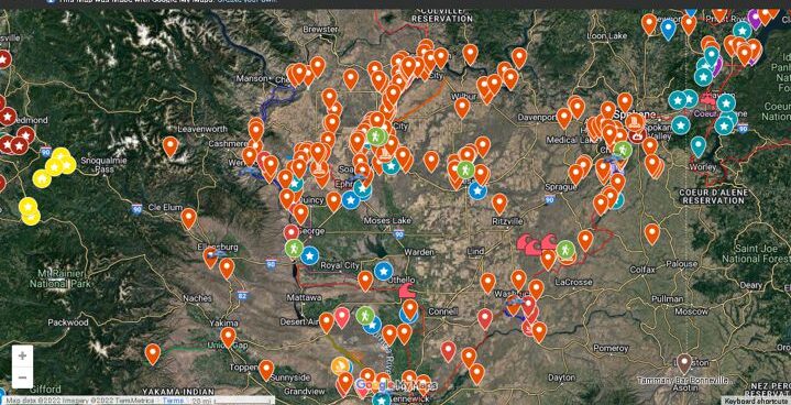
If you’ve ever tried to explore the Ice-Age Floods with a guidebook you’ll know how difficult and frustrating it can be to find and learn about the features in the area you’re visiting. Well, there’s now a solution to that problem; an interactive map that’s available wherever you have internet access. The map features over 300 points of interest throughout our 4-state area, with a description and images that slide out when you click on one of the markers. More features are being added all the time, and we’re planning to expand the map with features related to the Lake Bonneville Flood event that rampaged through the area during the time of the Ice-Age Floods. Since this is an internet-based map, it’s also easy to get driving directions to the site from wherever you are starting from. You can also easily build an informative field trip, exploring and learning about a number of other nearby features with just a few clicks of your mouse. We feel this may be the most useful field guide ever developed to explore ice-age Floods and glacial features throughout our 4-state region. AND it’s absolutely FREE! The only shortcomings we see are 1) the map requires internet access, which isn’t always available in far-flung areas of our region, and 2) we may not have every point-of-interest on the map (YET!). If we’re missing something you think is important we encourage you to submit your suggestion. We also appreciate any comments and/or corrections by email to Webmaster@IAFI.org. We sincerely hope you enjoy using this guide to poke around these fascinating ice-age features.