New ‘Friends of J Harlen Bretz’ Facebook Group

The owner of Boulderstrewn, J Harlen Bretz’s home in Illinois has started a new Facebook Group “Friends of J Harlen Bretz” He started the group to try and pull together people who appreciate the impact J Harlen had on geology in the last century. He and others have uncovered some interesting correspondence and papers reflecting some of Bretz’s wide ranging interests and contacts. It may well develop into an interesting communications board about Bretz and his life and accomplishments. You can join the group at https://www.facebook.com/groups/837636339993394, and offer any contributions you may have to share.
Rhyolite Erratic Rocks the News
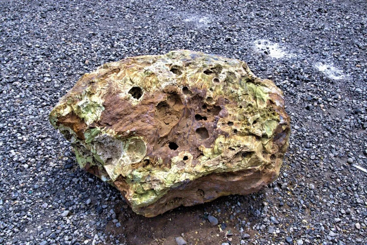
While doing ground preparation for the site of the new Lakeridge Middle School in Lake Oswego, Oregon, it was not unusual for Jacob Parker, Project Superintendent of Construction with Skanska to look at the boulders that had been dug up to see if any would be good for landscaping. What was unusual, this time, was the tan and yellow-greenish boulder that he spotted among the many basalt boulders. Using an app on his cell phone the rock was originally thought to be autunite, which contains uranium. This would not be good news for a school to have a radioactive boulder near students. Parker notified Paul Eskeldson, District Project Manager who informed the school district and they wanted it moved off the property. Eskeldson, who had heard a lecture about erratics by Rick Thompson, president of the Lower Columbia chapter of the Ice Age Floods Institute, emailed him a photo asking if the Tualatin Ice Age Foundation might be interested in adding to their collection. Thompson in turn contacted Dr. Scott Burns, Professor of Geology at Portland State University who immediately went out to see the boulder and took Dr. Martin Streck, PSU Professor of Geology specializing in mineralogy who recognized that it was rhyolite. Rhyolite, though native to eastern Oregon is not found west of the Cascade Mountains which makes this an extremely rare find. Research could only find one other mention of a rhyolite erratic, in Canby, Oregon, by none other than J Harlen Bretz in his The Late Pleistocene Submergence in the Columbia Valley of Oregon and Washington paper published in the October-November 1919 issue of the Journal of Geology. That erratic has been lost and it is not known if it even still exists. Finding this new boulder where it was, offered a great educational opportunity for the students at the school. On May 17th Dr. Scott Burns, standing next to the boulder, gave a short talk in the morning and again in the afternoon about how the 2,000 pound boulder was likely deposited between 15,000 to 18,000 years ago during the Lake Missoula Floods. Each student who wanted was able to take a small broken piece as a memento. Skanska issued a press release and invited the media, and several members of the local press came to cover the event. Over the following week the story was picked up by additional media including ABC, UPI and Newsweek giving it national exposure. But the most surprising one was when it appeared in the Borneo Bulletin giving the story international exposure. The boulder was then carefully hoisted into a truck for transport by Brian Clopton Excavating and taken to the Tualatin Heritage Center where it was installed near several granite and feldspar erratics they had moved in the past. Principal Schultz of Lakeridge Middle School said that even though the rock was discovered not to be a radioactive threat to students the school was very happy to have donated it so it can be on display in a place for the general public to see.
WA Geology Releases Stunning Lidar Images
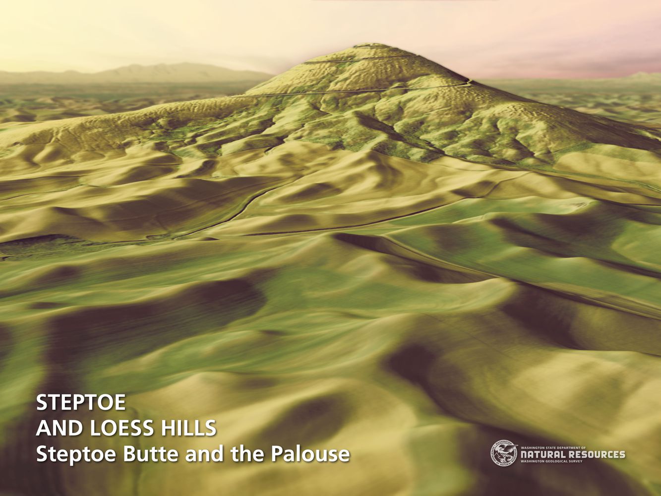
The Washington Geological Survey (WGS) has released 50 high-resolution lidar-derived images of the State’s geology and geomorphology through the Washington State DNR’s Flickr page. The images are available in 16:9 format (7,200 x 4,050 pixels) and 4:3 format (7,200 x 5,400 pixels). Ten of the images are new (see below) and 40 of them were previously available as screen wallpaper (at a lower resolution). Additionally, WGS has released several full-resolution lidar image series that reveal the State’s geology. These images are great for earth science presentations, learning about lidar, and for using as digital wallpaper. They are also large enough to support large-format printing. Here are direct links to the image galleries:
The Washington 100 Geotourism Guide

Check out this video about the Washington 100, a cool new geotourism website by the Washington Geological Survey featuring 100 places to experience amazing geology in Washington State. Then explore the website itself at wa100.dnr.wa.gov
New Saber-Toothed Cat Species May Have Hunted Rhinos in America
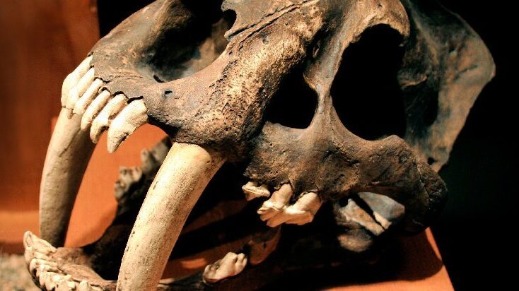
Using detailed fossil comparison techniques, scientists have been able to identify a giant new saber-toothed cat species, Machairodus lahayishupup, which would have prowled around the open spaces of North America between 5 and 9 million years ago. One of the biggest cats ever discovered, M. lahayishupup is estimated in this new study to have a body mass of some 274 kilograms (604 pounds) or so, and possibly even bigger. It’s an ancient relative of the well-known Smilodon, the so-called saber-toothed tiger. A total of seven M. lahayishupup fossil specimens, including upper arms and teeth, were analyzed and compared with other species to identify the new felid, with the fossils collected from museum collections in Oregon, Idaho, Texas, and California. Upper arms are crucial in these cats for killing prey, and the largest upper arm or humerus fossil discovered in the study was about 1.4 times the size of the same bone in a modern-day lion. That gives you an idea of just how hefty and powerful M. lahayishupup would have been. “We believe these were animals that were routinely taking down bison-sized animals,” says paleontologist Jonathan Calede from Ohio State University. “This was by far the largest cat alive at that time.” Rhinoceroses would have been abundant at the same and may have been animals that M. lahayishupup preyed on, alongside camels and sloths significantly bigger than the ones we’re used to today. Peering back so many millions of years into the past isn’t easy, and the researchers say that a more detailed saber-tooth cat family tree is going to be needed to work out exactly where this species fits in. The findings also open up some interesting evolutionary questions about these giant cats. “It’s been known that there were giant cats in Europe, Asia, and Africa, and now we have our own giant saber-toothed cat in North America during this period as well,” says Calede. “There’s a very interesting pattern of either repeated independent evolution on every continent of this giant body size in what remains a pretty hyper-specialized way of hunting, or we have this ancestral giant saber-toothed cat that dispersed to all of those continents. It’s an interesting paleontological question.” Excerpted from SCIENCE ALERT article by DAVID NIELD8 MAY 2021
Spokane Riverfront Park IAF Playground – Public Opening May 21
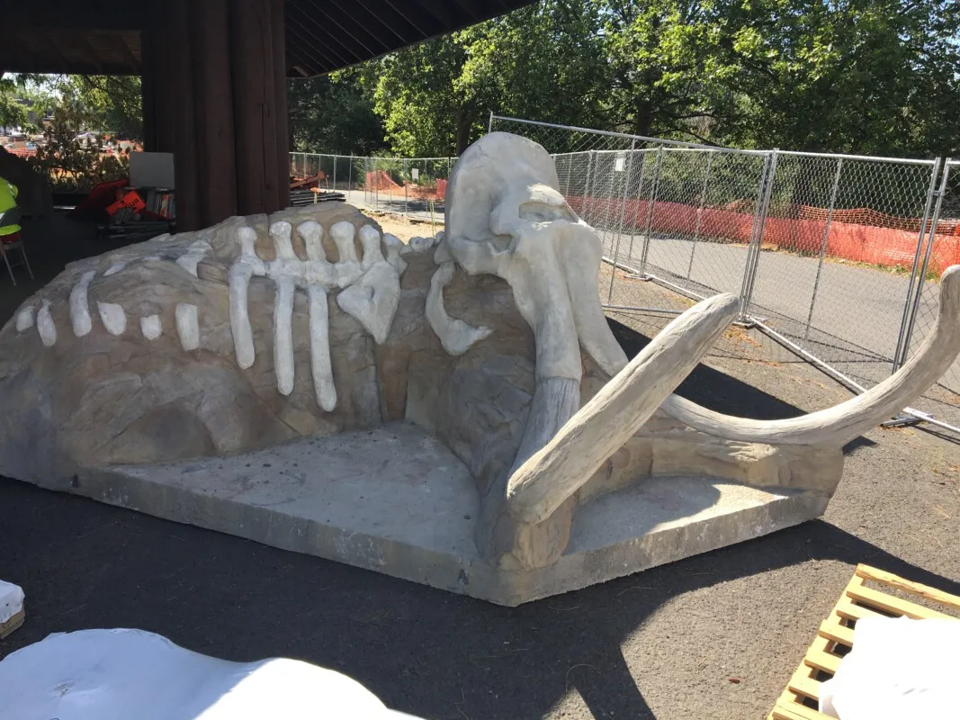
There will be an Invitation-Only Grand Opening of the Ice-Age Floods Playground in Spokane’s Riverfront Park on Friday, May 21st from 11:00 to noon. Then playground will the be open to the public beginning at noon on Friday. All ages are welcome! Click here for more information. The “soft ”pavement has been poured, including some mammoth tracks leading to various features. The Flood Fall is spectacular & will be sure to elicit many screams of delight. The present educational texts & images are temporary. The permanent ones will be installed at a later date.
New Book, “Ice Age Floodscapes of the Pacific Northwest”
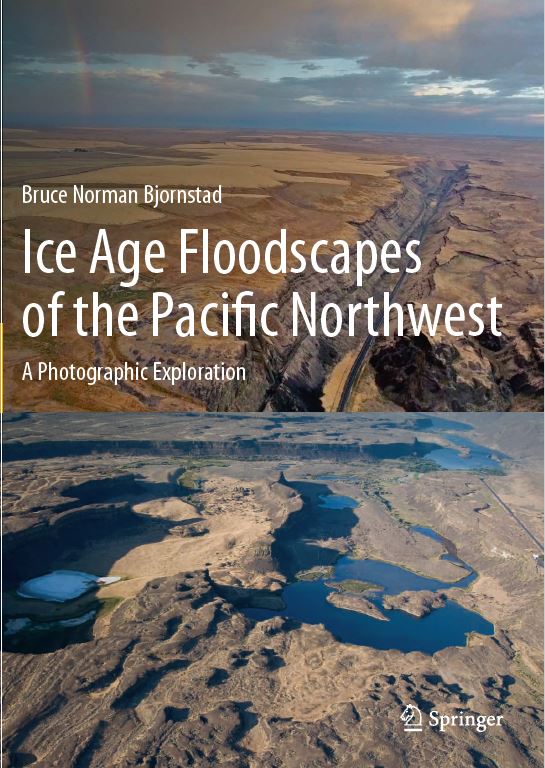
Bruce Bjornstad has a new book, “Ice Age Floodscapes of the Pacific Northwest“, just released by publisher Springer. This heavily illustrated book contains descriptions and geologic interpretations of photographs (mostly aerial) illustrating the power and magnitude of repeated Ice Age flooding in the Pacific Northwest, as recently as 14,000 years ago. The scale of the Ice Age floods was so huge that today it is often difficult to see the evidence from ground level. However, from the air, landforms created by the floods often come into clear focus. Aerial images, obtained via unmanned aerial vehicle (drone) as well as fixed-wing airplane, add a new perspective on these Earth-changing events gathered by dozens of scientists since 1923.
WSU Field Trips with Last & Reidel

Explore several interesting geologic and floods features in 6 self-guided field trips prepared by Steven Reidel and George Last for classes at Washington State University. Explore several other self-guided field trip guides in our collection.
IAF-National Geologic Trail Program Manager Selected

The National Park Service has selected Justin Radford as the Ice Age Floods National Geologic Trail’s new Program Manager, the Trail’s first permanent full-time staff member. Mr. Radford follows in the footsteps of many who have worked tirelessly to bring Ice Age Flood National Geologic Trail into existence. He will be duty stationed in Coulee Dam, Washington and will also join the Management Team of Lake Roosevelt NRA. “Traveling the region is an experience of geologic power and grace. It is an honor to be selected to help ensure all our visitors have a chance to connect with the special places along Ice Age Floods National Geologic Trail,” said Mr. Radford. ” I am looking forward to working with our partners to help every visitor be as excited about the Trail as I am.” “Justin brings a wealth of experience in planning and developing visitor services to Ice Age Floods National Geologic Trail,” said Superintendent Dan Foster. “His depth of experience, along with a dedication to providing quality visitor opportunities, make him a great fit for this position.” Justin has a BA in Philosophy from the University of Colorado, Boulder and over 23 years of previous public service most recently as the Executive Officer for Overseas Operations at the American Battle Monuments Commission (ABMC). Prior to his work with ABMC he spent 17 years with the National Park Service’s Harpers Ferry Center for Media Development as a project manager, supervisor and program coordinator for the development of visitor centers and interpretive media across the United States. While with the NPS Mr. Radford helped to create several new national park sites including Selma to Montgomery National Historic Trail and Tuskegee Airmen National Historic Site. His expertise in visitor experience development, project management and stakeholder coordination make him uniquely suited to the future needs of Ice Age Floods National Geologic Trail. Ice Age Floods Institute is thrilled to have such a talented and dynamic leader of the Ice Age Floods National Geologic Trail as a partner in sharing the story of the incredible Ice Age Floods.
Best Time And Place to Live in The Milky Way Is Not Here

An interesting article about the cosmic dangers to life that many may not be aware of: More and more, it seems that the existence and persistence of life on Earth is the result of sheer luck. According to a new analysis of the history of the Milky Way, the best time and place for the emergence of life isn’t here, or now, but over 6 billion years ago on the galaxy’s outskirts. That specific location in space and time would have afforded a habitable world the best protection against the gamma-ray bursts and supernovae that blasted space with deadly radiation. As of about 4 billion years ago, the central regions of the galaxy (which include the Solar System) became safer than the outskirts – safe enough for life to emerge, if not quite as safe as the outskirts had been. Read more at https://www.sciencealert.com/when-was-the-best-time-and-place-to-live-in-the-milky-way-not-where-we-are-apparently