Ice Age Floods Institute at GSA Convention

In August the Ice Age Floods Institute was offered an opportunity to share an exhibitor booth with the Tualatin Ice Age Floods Foundation (TIAFF) at a major geological conference, the October 10-13 Geological Society of America (GSA) Convention in Portland, OR. This gave IAFI an opportunity to present the Floods Story and educate a worldwide assemblage of geological professionals, researchers, and students, many of whom were not even aware of the Floods or their immense scope. The IAFI Board jumped at this opportunity, approving the registration cost and putting the booth development in the hands of the Columbia River Gorge Chapter President and IAFI Webmaster, Lloyd DeKay, aided by IAFI Membership Secretary, Sylvia Thompson, who also represented TIAFF along with Dr. Scott Burns of Portland State University. With Dr. Burns influence, we were able to acquire a corner booth space very near the main GSA area that ensured a good parade of participant traffic past our booth. We used 3D modeling software to design the booth to scale, then began assembling the materials for the booth. We used QGIS software, with assistance from Stacy Warren of Eastern Washington University, to develop a new map that highlighted the Floods paths, various glacial and temporary lakes along the floods path, as well as the final resting place of much of the sediment eroded by the Floods on the Astoria Submarine Fan. We then printed the map and other images, purchased, trimmed and covered 2” foam insulation boards for display walls, borrowed tables, made table covers, and gathered IAFI Store materials for sale. The day of reckoning came Oct. 8th, when we moved everything to the Oregon Convention Center and set it all up. The Exhibit Hall opened at 5:00pm and we began telling the story that would repeat many times over the next 4 days to people from around the world. We talked with relative locals (WA, OR, ID, MT, NV and CA), people from other parts of the US (at least AK, AZ, UT, CO, TX, AR, IA, KS, KY, IL, MN, WI, LA, GA, NC, SC, AL, FL, NJ, NY, MA, NH, VT, RI, CT), and several countries (including Canada, Finland, Holland, UK, Italy, Morocco, Zimbabwe, India, China, Australia, Columbia, Mexico, and Costa Rica). In all, there were 2,700 in-person participants this year. Our booth was one of the most popular and usually had 2-5 people at a time looking at the displays. Geologic luminaries such as Vic Baker, Richard Waitt, Scott Burns, Bruce Bjornstad and Nick Zentner also stopped by, attracting even more visitors to the booth. We gave away National Park Service, IAFI and TIAFF brochures and we sold books, maps, hats and t-shirts as well as our packets of chapter brochures. Though it involved a lot of time and work for the members and volunteers who manned the booth, we feel it was well worth the effort to educate and spread the Story of the Ice Age Floods. Many thanks to IAFI members Lloyd DeKay, Sylvia and Rick Thompson, and TIAFF volunteers Jerianne Thompson, Yvonne Addington and Linda Moholt for helping make this effort a stunning success. And we now have materials and experience that will serve well for future professional, educational and general public events like this.
America’s Geoheritage II
Identifying, Developing, and Preserving America’s Natural Legacy – America is endowed with places that embody a rich geoheritage, from sites where indigenous people subsisted for millennia, to mines that furnished the raw materials that built U.S. industry, to mountain ranges and river gorges with unparalleled recreational opportunities, to field sites where students can truly understand a geological process, to places of aesthetic or spiritual value, and many more across all states and territories. In order to assess the status of geoheritage and the activities of its practitioners in the United States in light of social, political, and environmental changes over the past ten years, the National Academies of Sciences Engineering and Medicine convened a series of virtual webinars and a workshop. From September to December 2020, a Distinguished Speakers Webinar Program composed of eight webinars provided an overview of geoheritage initiatives, as well as focused presentations on geoheritage related to federal and state lands, cultural heritage, education, research, and economic development and geotourism. In January 2021, 101 land managers, state geologists, educators, researchers, and members and staff of professional societies and nongovernmental organizations participated in a virtual writing workshop to aggregate and organize community input on strategies and best practices in developing geoheritage sites across the United States. The participants were divided into focus groups that roughly aligned with the topics explored in the fall 2020 workshops. The groups worked synchronously and asynchronously over the course of a week, then presented their ideas in a plenary session. This free publication summarizes the presentations and discussion of the webinars and workshop.
23,000 Year Old Human Footprints Found in New Mexico

Articles in Science Alert and the New York Times report on a well documented age for many sets of human footprints as old as 23,000 years in the ancient lake shore sands of White Sands, New Mexico. “The footprints were first discovered in 2009 by David Bustos, the park’s resource program manager. Over the years, he has brought in an international team of scientists to help make sense of the finds. Together, they have found thousands of human footprints across 80,000 acres of the park. One path was made by someone walking in a straight line for a mile and a half. Another shows a mother setting her baby down on the ground. Other tracks were made by children.” Beginning in 2019, two United States Geological Survey (USGS) research scientists, Dr. Jeffrey Pigati and Kathleen Springer, began working on the site and found ancient seeds of ditch grass associated with various sets of footprints. The oldest footprints so far have been found in seed beds radiocarbon age-dated as old as 22,800 years, and the youngest footprints dated to about 21,130 years ago. Some scientists still have concerns the seeds might have absorbed older carbon from the lake waters. But in general this research is strongly indicative that humans were present in the Americas long before the generally accepted 15,600-year-old footprint found in Chile or the 13,000 year age of human tools found near Clovis, NM. If humans were well established in New Mexico 23,000 years ago, they must have started spreading down from Alaska long before that. “That starts to wind back the clock,” said Dr. Reynolds of Bournemouth University. Some researchers feel the migration might have been along the coast during the last major ice advance of the Pleistocene, while others argue people could have traveled inland more than 32,000 years ago, before Ice Age glaciers reached their maximum extent and blocked off that route. Regardless of the possible migration route, this new evidence opens up new possibilities that humans may have been present in our local area even before the earliest of the Ice Age Floods, about 18,000 years ago. While the floods could have wiped away most traces of early people in the area, the window of human habitation may be much greater than scientifically documented to date.
Remembering Tom Foster

Tom Foster was an incredible photographer, videographer, and an intrepid fan of the Ice Age Floods who shared his work on the Floods through his HugeFloods.com website. His great friend, Bruce Bjornstad, put together this remembrance of Tom and his work,. The Ice Age Floods Institute and all its members owe a great debt of gratitude to both Tom and Bruce. We’re happy to share this remembrance in homage to Tom and his talent and dedication to sharing the Ice Age Floods story.
“Pend Oreille Country”, Awe-Inspiring Geology

What happened in PEND OREILLE COUNTRY about 20,000 years ago is truly amazing, with a flood of biblical proportions creating Idaho’s deepest lake. Outdoor Idaho tried to capture it in this short clip and the hour-long PEND OREILLE COUNTRY can be viewed at https://www.idahoptv.org/shows/outdooridaho/
WWII Metallic Sodium Disposal in Lake Lenore, WA
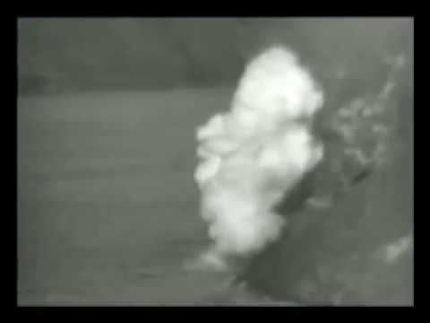
At the end of World War 2, the United States Army had an excess of metallic sodium left over from the war, which was used in the manufacture of incendiary bombs. The original plan was to sell off the surplus quantity, and when the material was advertised for sale it aroused the interest of several companies. But when the metal drums where the sodium was stored was inspected, it was found that the containers had deteriorated to such an extent that handling and shipping was extremely hazardous. Sodium reacts violently with water producing a lot of heat and hydrogen gas, which often ignites from the generated heat causing explosions. The railroad companies refused to handle the material in the substandard containers, thereby leaving the Army with a perplexing problem: how to dispose of 9,000 tons of extremely reactive sodium. The War Assets Administration decided to dump the sodium into a lake in Washington. To minimize the environmental impact of dumping thousands of tons of sodium in water, the Army chose Lake Lenore in Grant County because of its alkaline waters and lack of fish. Lake Lenore is part of a chain of terminal lakes, lakes that don’t have an outlet, in the lower Grand Coulee. In a newsreel published in 1947, one can see the Army rolling down barrel after barrel of metallic sodium from a cliff onto the frozen lake. Once in water, the drums were shot by machine guns to cause puncture and allow the sodium to come in contact with water. As the sodium reacted with water, an estimated 162,000 cubic feet of hydrogen gas was produced, which caught fire producing a series of spectacular explosions. “A once-lethal war chemical becomes a peacetime pyrotechnic display,” says the narrator in the video. According to a paper published in 1958, the waters of Lake Lenore is already rich in sodium salts of sulfate, bicarbonate, carbonate, and chloride. The lake is highly alkaline with an average pH of 9.9, thus the dumping of 9,000 kg of sodium would have produced “less than a rounding error of pH change.” Today, Lake Lenore is no longer devoid of fish. Since the mid-1980s, the state has been stocking the lake with Lahontan cutthroat trout that thrive in alkaline waters. The Lahontan is now the top aquatic predator in Lenore and in several other alkali lakes around North America. Original article by Kaushik Patowary in https://www.amusingplanet.com/2021/07/disposing-sodium-in-lake-lenore.html
WA-DNR Educational Volcano Web Guide
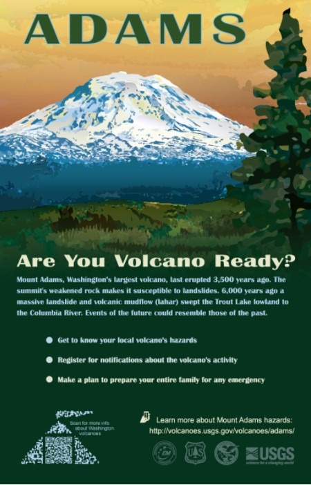
In May WA-DNR released a new educational web guide that helps students of all ages prepare for volcano hazards and learn more about these natural phenomena. Take a look and send your feedback: geology@dnr.wa.gov They partnered with some of Washington’s regional science coordinators to create this product, and with their help hosted a Zoom professional development session (Have a Blast! Volcano Science with the Washington Geological Survey) with K-12 teachers across the state on the morning of Saturday, May 22nd. Teachers earned 6 STEM clock hours and a small stipend for participating in our class. The class was broken into three sessions. The first 2 hours of the session were for asynchronous work, where the teachers worked through the web guide themselves. The teachers submitted feedback regarding their experiences with our web guide, the usability of our guide, and whether the content was appropriate for their students. The second 2 hours of the session involved a Zoom call which sought teacher feedback on the guide and discussed how the guide could be adapted to fit various student’s needs, and also answered questions the teachers asked about volcanoes and earth science more broadly, and the teachers filled out this fun word cloud: The final 2 hours of the session were for more asynchronous work, where teachers summarized their learning about volcanoes and created their Community Hazards Plan capstone projects. If you are a student or a teacher you can email feedback to DNR on this project at: geology@dnr.wa.gov
Chicxulub Asteroid Tsunami ‘Megaripples’
In what may be the most dramatic mass extinction in Earth’s history, an asteroid impacted our planet 66 million years ago near what is now Chicxulub on the Yucatan Peninsula. The resulting hellscape extinguished 75 percent of then living species – including all non-avian dinosaurs. Over the last few years, scientists have discovered many more traces of this cataclysmic impact, providing us with ever greater details of its extreme aftermath – from world-encircling dust to wildfires up to 1,500 kilometers (930 miles) from the impact site. In 2019, a team found fossil records of the immediate hours after, including evidence of debris swept up by the resulting tsunami. Now, researchers have discovered enormous megaripples engraved by the tsunami in sediments 1,500 meters (5,000 feet) below what is now central Louisiana. By analyzing seismic imaging data for central Louisiana, gained from a fossil fuel company., the team determined the imprinted ripple crests form a straight line right back to the Chicxulub crater and their orientation is consistent with the impact. These megaripple features have average wavelengths of 600 meters and average wave heights of 16 meters making them the largest ripples documented on Earth. Compare that to the largest Camas Prairie megaripple at 289m x 17m. Modelling of this monstrous tsunami suggests its waves would have reached a staggering 1,500 meters high (nearly 1 mile) after the Richter scale 11 megaearthquake triggered by the collision. The aftereffects would have been particularly devastating in the regions surrounding the impact site, sweeping sea life onto land and land life into the sea. “Tsunami continued for hours to days as they reflected multiple times within the Gulf of Mexico while diminishing in amplitude,” the team wrote. What carved out the ripples we can still detect today were the forces from the massive walls of water smashing into the shallow shelf near the shores, and reflecting back towards their source. Excerpted from: sciencealert.com/tsunami-megaripples-from-the-dinosaur-killing-asteroid-impact-discovered-in-louisiana Read another article at: https://www.sciencetimes.com/articles/32252/20210713/dino-killer-space-rock-left-fossilized-megaripples-mile-high-giant.htm
Riverfront Park’s New Ice Age Floods Playground

There’s A New Ice Age Floods Themed Playground And Splash Pad At Riverfront Park In Spokane. Riverfront Park is an iconic part of Spokane. Since 1974, this has been a gathering place for families, a venue for all kinds of events, and an all-around fun place to be. And as of May 2021, it’s home to a new Ice Age Floods themed playground. Riverfront Park encompasses 100 acres of land that has quite a history. Native Americans gathered and fished at the nearby falls, and pioneers settled here and started the city of Spokane in the late 1800s. But it was in 1974, when Spokane hosted Exposition ’74, “The World’s Fair,” that this park was really put on the map. Construction for the Ice Age Floods playground officially started in August of 2020, although the crew broke ground a year earlier. With the ground made of rubber and artificial turf, this is a safe place for kids to play. The playground features basketball courts, a wheels park, a splash pad, and multiple play and climbing areas. Read and see more in the article this was excerpted from at https://www.onlyinyourstate.com/washington/riverfront-park-ice-age-playground-wa
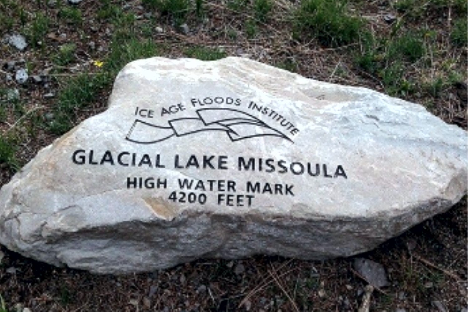
On the Trail of High Water Markers for Glacial Lake Missoula
Three more high water markers have been placed by the Glacial Lake Missoula chapter in cooperation with the Montana Department of Transportation and Montana Department of Fish, Wildlife, and Parks. These markers all designate the furthest extension of Glacial Lake Missoula in the Clark Fork River valley near Gold Creek – one is located at a popular fishing access site, and the other two are located at Truck Stops on I-90 in both directions near Drummond at exit 166. The total number of markers is now 10. Five of these are located on popular trails in Missoula – two on Mt Jumbo, two on Mt Sentinel, and one on Mt Dean Stone. These are most easily reached by separate hikes involving a short but relatively steep climb with a panoramic view of Missoula and surrounding mountains. Theoretically they could all be reached in a single day on one long and difficult hike by connecting trails and city streets. We are not aware of anyone who has been able to do that but might want to issue it as a challenge. The other markers in addition to the three at Gold Creek locations are all within a short drive from Missoula up the Bitterroot and Blackfoot/Clearwater drainages of the Clark Fork River to Ovando and Lake Como. These are beautiful valleys surrounded by high peaks Ovando is a popular stop for bicyclists; Lake Como has a swimming beach and a fairly level trail around the lake. Additional locations are being considered The locations and GPS coordinates of these markers are listed on the IAFI interactive map, and they are also individually listed and pictured on the Glacial Lake Missoula chapter website – GlacialLakeMissoula.org – under Local Highlights. The markers are all identified by Glacial Lake Missoula wording with the IAFI logo and the high water elevation, but only those placed by the Montana Department of Transportation have explanatory signage.