Chicxulub Asteroid Tsunami ‘Megaripples’
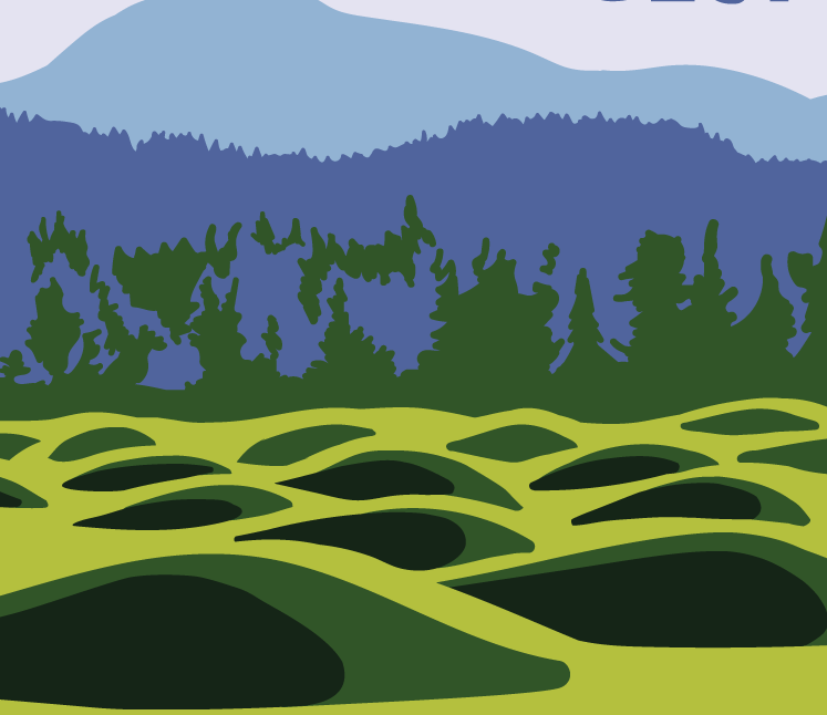
In what may be the most dramatic mass extinction in Earth’s history, an asteroid impacted our planet 66 million years ago near what is now Chicxulub on the Yucatan Peninsula. The resulting hellscape extinguished 75 percent of then living species – including all non-avian dinosaurs. Over the last few years, scientists have discovered many more traces of this cataclysmic impact, providing us with ever greater details of its extreme aftermath – from world-encircling dust to wildfires up to 1,500 kilometers (930 miles) from the impact site. In 2019, a team found fossil records of the immediate hours after, including evidence of debris swept up by the resulting tsunami. Now, researchers have discovered enormous megaripples engraved by the tsunami in sediments 1,500 meters (5,000 feet) below what is now central Louisiana. By analyzing seismic imaging data for central Louisiana, gained from a fossil fuel company., the team determined the imprinted ripple crests form a straight line right back to the Chicxulub crater and their orientation is consistent with the impact. These megaripple features have average wavelengths of 600 meters and average wave heights of 16 meters making them the largest ripples documented on Earth. Compare that to the largest Camas Prairie megaripple at 289m x 17m. Modelling of this monstrous tsunami suggests its waves would have reached a staggering 1,500 meters high (nearly 1 mile) after the Richter scale 11 megaearthquake triggered by the collision. The aftereffects would have been particularly devastating in the regions surrounding the impact site, sweeping sea life onto land and land life into the sea. “Tsunami continued for hours to days as they reflected multiple times within the Gulf of Mexico while diminishing in amplitude,” the team wrote. What carved out the ripples we can still detect today were the forces from the massive walls of water smashing into the shallow shelf near the shores, and reflecting back towards their source. Excerpted from: sciencealert.com/tsunami-megaripples-from-the-dinosaur-killing-asteroid-impact-discovered-in-louisiana Read another article at: https://www.sciencetimes.com/articles/32252/20210713/dino-killer-space-rock-left-fossilized-megaripples-mile-high-giant.htm
Riverfront Park’s New Ice Age Floods Playground

There’s A New Ice Age Floods Themed Playground And Splash Pad At Riverfront Park In Spokane. Riverfront Park is an iconic part of Spokane. Since 1974, this has been a gathering place for families, a venue for all kinds of events, and an all-around fun place to be. And as of May 2021, it’s home to a new Ice Age Floods themed playground. Riverfront Park encompasses 100 acres of land that has quite a history. Native Americans gathered and fished at the nearby falls, and pioneers settled here and started the city of Spokane in the late 1800s. But it was in 1974, when Spokane hosted Exposition ’74, “The World’s Fair,” that this park was really put on the map. Construction for the Ice Age Floods playground officially started in August of 2020, although the crew broke ground a year earlier. With the ground made of rubber and artificial turf, this is a safe place for kids to play. The playground features basketball courts, a wheels park, a splash pad, and multiple play and climbing areas. Read and see more in the article this was excerpted from at https://www.onlyinyourstate.com/washington/riverfront-park-ice-age-playground-wa
On the Trail of High Water Markers for Glacial Lake Missoula
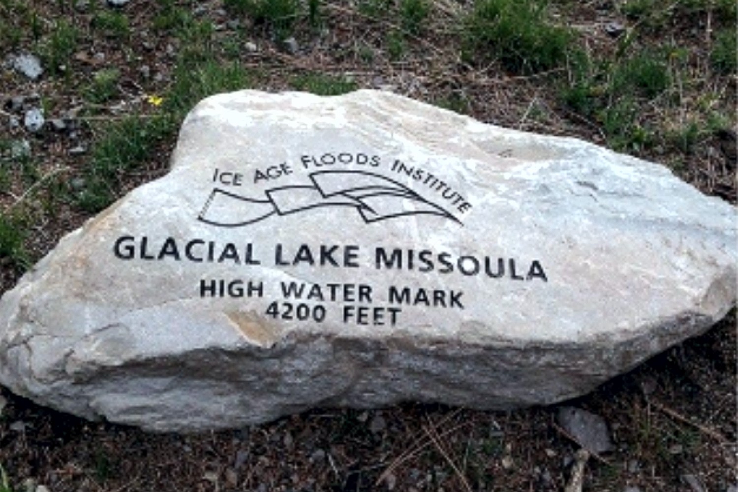
Three more high water markers have been placed by the Glacial Lake Missoula chapter in cooperation with the Montana Department of Transportation and Montana Department of Fish, Wildlife, and Parks. These markers all designate the furthest extension of Glacial Lake Missoula in the Clark Fork River valley near Gold Creek – one is located at a popular fishing access site, and the other two are located at Truck Stops on I-90 in both directions near Drummond at exit 166. The total number of markers is now 10. Five of these are located on popular trails in Missoula – two on Mt Jumbo, two on Mt Sentinel, and one on Mt Dean Stone. These are most easily reached by separate hikes involving a short but relatively steep climb with a panoramic view of Missoula and surrounding mountains. Theoretically they could all be reached in a single day on one long and difficult hike by connecting trails and city streets. We are not aware of anyone who has been able to do that but might want to issue it as a challenge. The other markers in addition to the three at Gold Creek locations are all within a short drive from Missoula up the Bitterroot and Blackfoot/Clearwater drainages of the Clark Fork River to Ovando and Lake Como. These are beautiful valleys surrounded by high peaks Ovando is a popular stop for bicyclists; Lake Como has a swimming beach and a fairly level trail around the lake. Additional locations are being considered The locations and GPS coordinates of these markers are listed on the IAFI interactive map, and they are also individually listed and pictured on the Glacial Lake Missoula chapter website – GlacialLakeMissoula.org – under Local Highlights. The markers are all identified by Glacial Lake Missoula wording with the IAFI logo and the high water elevation, but only those placed by the Montana Department of Transportation have explanatory signage.
New ‘Friends of J Harlen Bretz’ Facebook Group

The owner of Boulderstrewn, J Harlen Bretz’s home in Illinois has started a new Facebook Group “Friends of J Harlen Bretz” He started the group to try and pull together people who appreciate the impact J Harlen had on geology in the last century. He and others have uncovered some interesting correspondence and papers reflecting some of Bretz’s wide ranging interests and contacts. It may well develop into an interesting communications board about Bretz and his life and accomplishments. You can join the group at https://www.facebook.com/groups/837636339993394, and offer any contributions you may have to share.
Rhyolite Erratic Rocks the News
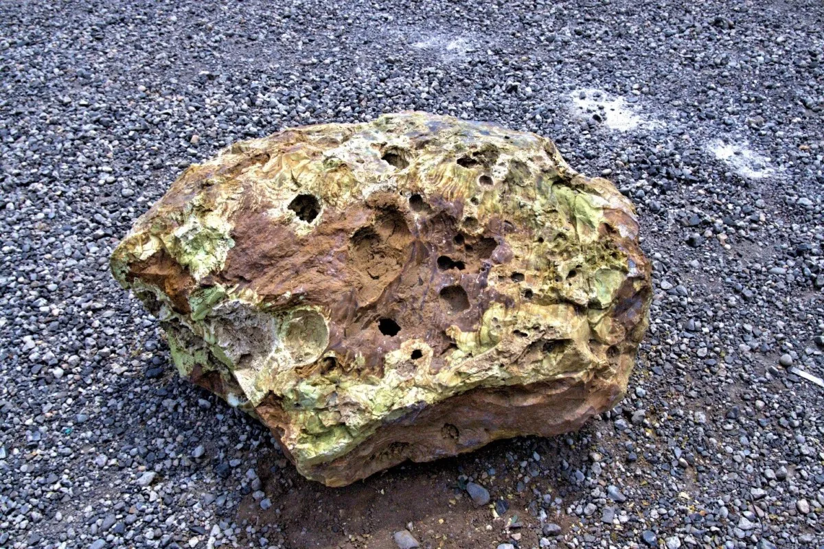
While doing ground preparation for the site of the new Lakeridge Middle School in Lake Oswego, Oregon, it was not unusual for Jacob Parker, Project Superintendent of Construction with Skanska to look at the boulders that had been dug up to see if any would be good for landscaping. What was unusual, this time, was the tan and yellow-greenish boulder that he spotted among the many basalt boulders. Using an app on his cell phone the rock was originally thought to be autunite, which contains uranium. This would not be good news for a school to have a radioactive boulder near students. Parker notified Paul Eskeldson, District Project Manager who informed the school district and they wanted it moved off the property. Eskeldson, who had heard a lecture about erratics by Rick Thompson, president of the Lower Columbia chapter of the Ice Age Floods Institute, emailed him a photo asking if the Tualatin Ice Age Foundation might be interested in adding to their collection. Thompson in turn contacted Dr. Scott Burns, Professor of Geology at Portland State University who immediately went out to see the boulder and took Dr. Martin Streck, PSU Professor of Geology specializing in mineralogy who recognized that it was rhyolite. Rhyolite, though native to eastern Oregon is not found west of the Cascade Mountains which makes this an extremely rare find. Research could only find one other mention of a rhyolite erratic, in Canby, Oregon, by none other than J Harlen Bretz in his The Late Pleistocene Submergence in the Columbia Valley of Oregon and Washington paper published in the October-November 1919 issue of the Journal of Geology. That erratic has been lost and it is not known if it even still exists. Finding this new boulder where it was, offered a great educational opportunity for the students at the school. On May 17th Dr. Scott Burns, standing next to the boulder, gave a short talk in the morning and again in the afternoon about how the 2,000 pound boulder was likely deposited between 15,000 to 18,000 years ago during the Lake Missoula Floods. Each student who wanted was able to take a small broken piece as a memento. Skanska issued a press release and invited the media, and several members of the local press came to cover the event. Over the following week the story was picked up by additional media including ABC, UPI and Newsweek giving it national exposure. But the most surprising one was when it appeared in the Borneo Bulletin giving the story international exposure. The boulder was then carefully hoisted into a truck for transport by Brian Clopton Excavating and taken to the Tualatin Heritage Center where it was installed near several granite and feldspar erratics they had moved in the past. Principal Schultz of Lakeridge Middle School said that even though the rock was discovered not to be a radioactive threat to students the school was very happy to have donated it so it can be on display in a place for the general public to see.
WA Geology Releases Stunning Lidar Images
The Washington Geological Survey (WGS) has released 50 high-resolution lidar-derived images of the State’s geology and geomorphology through the Washington State DNR’s Flickr page. The images are available in 16:9 format (7,200 x 4,050 pixels) and 4:3 format (7,200 x 5,400 pixels). Ten of the images are new (see below) and 40 of them were previously available as screen wallpaper (at a lower resolution). Additionally, WGS has released several full-resolution lidar image series that reveal the State’s geology. These images are great for earth science presentations, learning about lidar, and for using as digital wallpaper. They are also large enough to support large-format printing. Here are direct links to the image galleries:
The Washington 100 Geotourism Guide
Check out this video about the Washington 100, a cool new geotourism website by the Washington Geological Survey featuring 100 places to experience amazing geology in Washington State. Then explore the website itself at wa100.dnr.wa.gov
New Saber-Toothed Cat Species May Have Hunted Rhinos in America
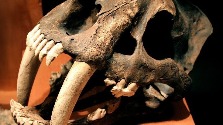
Using detailed fossil comparison techniques, scientists have been able to identify a giant new saber-toothed cat species, Machairodus lahayishupup, which would have prowled around the open spaces of North America between 5 and 9 million years ago. One of the biggest cats ever discovered, M. lahayishupup is estimated in this new study to have a body mass of some 274 kilograms (604 pounds) or so, and possibly even bigger. It’s an ancient relative of the well-known Smilodon, the so-called saber-toothed tiger. A total of seven M. lahayishupup fossil specimens, including upper arms and teeth, were analyzed and compared with other species to identify the new felid, with the fossils collected from museum collections in Oregon, Idaho, Texas, and California. Upper arms are crucial in these cats for killing prey, and the largest upper arm or humerus fossil discovered in the study was about 1.4 times the size of the same bone in a modern-day lion. That gives you an idea of just how hefty and powerful M. lahayishupup would have been. “We believe these were animals that were routinely taking down bison-sized animals,” says paleontologist Jonathan Calede from Ohio State University. “This was by far the largest cat alive at that time.” Rhinoceroses would have been abundant at the same and may have been animals that M. lahayishupup preyed on, alongside camels and sloths significantly bigger than the ones we’re used to today. Peering back so many millions of years into the past isn’t easy, and the researchers say that a more detailed saber-tooth cat family tree is going to be needed to work out exactly where this species fits in. The findings also open up some interesting evolutionary questions about these giant cats. “It’s been known that there were giant cats in Europe, Asia, and Africa, and now we have our own giant saber-toothed cat in North America during this period as well,” says Calede. “There’s a very interesting pattern of either repeated independent evolution on every continent of this giant body size in what remains a pretty hyper-specialized way of hunting, or we have this ancestral giant saber-toothed cat that dispersed to all of those continents. It’s an interesting paleontological question.” Excerpted from SCIENCE ALERT article by DAVID NIELD8 MAY 2021
Spokane Riverfront Park IAF Playground – Public Opening May 21
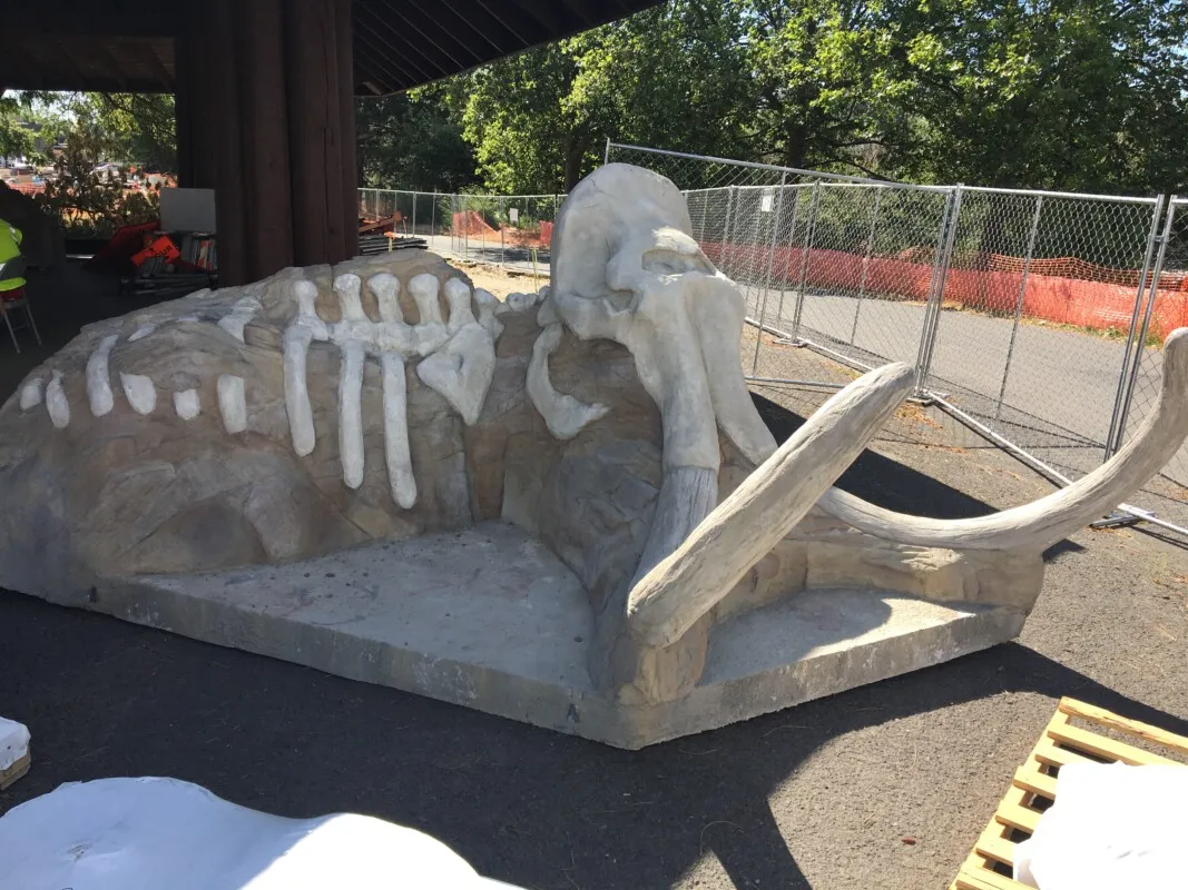
There will be an Invitation-Only Grand Opening of the Ice-Age Floods Playground in Spokane’s Riverfront Park on Friday, May 21st from 11:00 to noon. Then playground will the be open to the public beginning at noon on Friday. All ages are welcome! Click here for more information. The “soft ”pavement has been poured, including some mammoth tracks leading to various features. The Flood Fall is spectacular & will be sure to elicit many screams of delight. The present educational texts & images are temporary. The permanent ones will be installed at a later date.
New Book, “Ice Age Floodscapes of the Pacific Northwest”
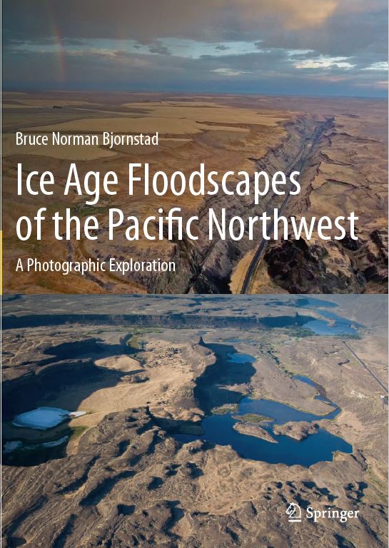
Bruce Bjornstad has a new book, “Ice Age Floodscapes of the Pacific Northwest“, just released by publisher Springer. This heavily illustrated book contains descriptions and geologic interpretations of photographs (mostly aerial) illustrating the power and magnitude of repeated Ice Age flooding in the Pacific Northwest, as recently as 14,000 years ago. The scale of the Ice Age floods was so huge that today it is often difficult to see the evidence from ground level. However, from the air, landforms created by the floods often come into clear focus. Aerial images, obtained via unmanned aerial vehicle (drone) as well as fixed-wing airplane, add a new perspective on these Earth-changing events gathered by dozens of scientists since 1923.