Asteroid That Decimated the Dinosaurs May Have Struck in Spring
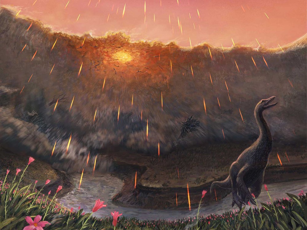
Spring may have been when a roughly seven-mile-wide asteroid struck the Earth, immediately triggering the mass extinction that would wipe out 76 percent of known species. That key piece of timing doesn’t come from dinosaurs, but from the fish that swam in the waters dinosaurs drank from. By studying the fossil bones of these fish and comparing them to their modern counterparts, Vrije Universiteit Amsterdam paleontologist Melanie During and colleagues have come to the conclusion that the impact that ended the Age of Dinosaurs most likely occurred in the spring. Like their modern counterparts, ancient sturgeons and paddlefish of the Hell Creek Formation, found in the “Tanis” fossil site in North Dakota, grew in cycles. Those researchers proposed that this place contains critical clues about the first minutes and hours of what transpired after impact—including well-preserved fossil fish that contain asteroid impact debris in their gills. During warmer months when food was plentiful, the ancient fish grew and added more bone tissue just as their modern relatives do. During cooler, harsher months, however, their growth slowed and left a line—called a line of arrested growth, or LAG—in their bones. In addition, the bones of these fish contained signatures from oxygen and carbon isotopes. The geochemical signals in these isotopes were influenced by what the fish were eating and the waters they swam in, a natural phenomenon that has been used by paleontologists to study everything from when early whales took to the seas to what plants ancient herbivores ate. Details of the prehistoric sturgeon and paddlefish bones indicate that these fish had not yet hit the peak of their annual growth spurt, which would be expected during the warmest parts of the year. The carbon isotope ratios in the paddlefish bones also match up with this pattern. If these ancient fish lived according to a similar annual cycle as their living relatives, then the signatures in their bones hint that they perished in spring. The fact that tiny spherules thrown into the air during the impact were found in their gills places the time of death within minutes or hours of the end-Cretaceous impact. Together, these lines of evidence suggest that the impact took place while the Northern Hemisphere was in spring and the Southern Hemisphere was still in winter. Read more in the Smithsonian Magazine article by Riley Black that this was taken from, or a Science Alert article that also recaps the paper published in Nature.
Waning Pleistocene Ice Sheet Affected Megaflood Paths and Local Shorelines
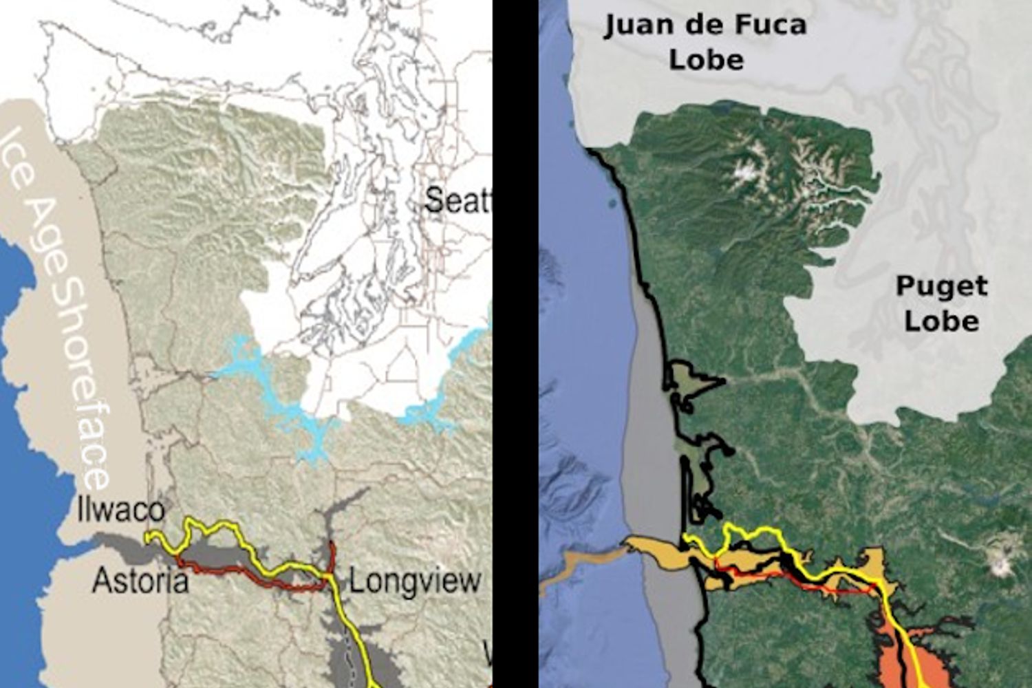
Have you ever thought about the how the weight of the ice-age Cordilleran ice sheet might affect the underlying Earth’s crust. There is strong evidence that the crust was depressed hundreds of feet beneath the ice, and since the crust is relatively thin and rigid over a plastic aesthenosphere, that also caused the crust for some distance beyond the ice margins to tilt toward the ice sheet. A new modeling study explored how changes in topography due to the solid Earth’s response to ice sheet loading and unloading might have influenced successive megaflood routes over the Channeled Scablands between 18 and 15.5 thousand years ago. The modeling found that deformation of Earth’s crust may played an important role in directing the erosion of the Channeled Scabland. Results showed that near 18 thousand year old floods could have traversed and eroded parts of two major Channeled Scabland tracts—Telford-Crab Creek and Cheney-Palouse. However, as the ice-age waned and the ice sheet diminished 15.5 thousand years ago, crustal isostatic rebound may have limited megaflood flow into the Cheney–Palouse tract. This tilt dependent difference in flow between tracts was governed by tilting of the landscape, which also affected the filling and overspill of glacial Lake Columbia directly upstream of the tracts. These results highlight one impact of crustal isostatic adjustment on megaflood routes and landscape evolution. Other studies have shown that relative ice-age sea levels were over 300 feet lower worldwide due to the volume of water locked up in ice sheets. Typical depictions of the shoreface extent are generally based on a 300 ft. depth contour, but there is strong evidence that shorelines were up to 200+ ft. higher than present day in marine areas adjacent to ice sheets, again because the crust was depressed by the weight of the ice sheer. A more accurate representation might show a much narrower shoreface in ice-free areas nearer to the ice sheet margin. However, in the Haida Gwaii Strait at the margin of the ice sheet the lower thickness of the ice sheet meant that local shorelines were as much as 550 feet lower than they are today. This was because the much greater thickness of the center of the ice sheet served to push upwards areas at the edge of the continental shelf in a crustal forebulge. It is now widely thought that these emergent ice-free land areas might have provided a viable coastal migration corridor for early peoples making their way to the Americas from Asia during the Pleistocene.
Visitor Centers are Rolling In on the IAF National Geologic Trail
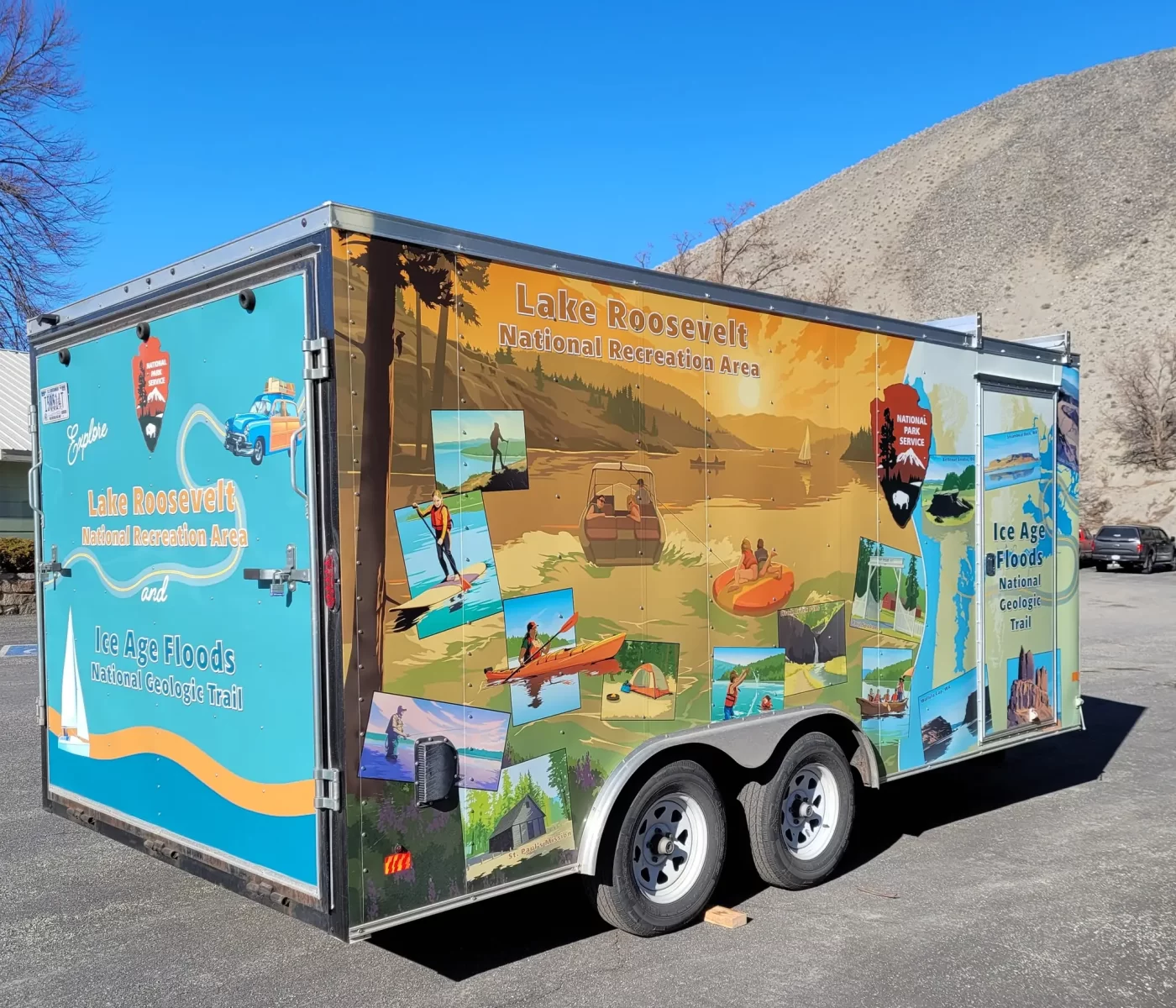
The Ice Age Floods National Geologic Trail now has an official Visitor Center, and there’s another one coming. The NPS doesn’t actually own any land for a permanent Visitor Center on the Trail, but in keeping with the spirit of the Trail these beauties will vagabond around the trail. Ideally, in this way they will reach many more people than a fixed building could. Kudos to the Lake Roosevelt NRA staff who early-on adopted official responsibility for the nascent Trail and continues to be the administrative hub and a driving force behind the Trail. After many moons of hard work, the first trailer (of two!) was delivered yesterday. Inside are exhibits on the critters, rocks, history, and more of the area! The sides are decorated with illustrations of people boating, fishing, hiking, camping, and playing in Lake Roosevelt, as well as scenic views along Lake Roosevelt. A wavy line and National Park Service arrowhead symbol separate the Ice Age Floods National Geologic Trail section, which has illustrations of geologic formations. They tell the story of the #IceAgeFloodsNGT as well as Lake Roosevelt NPS. We’re beyond excited to share them with you this summer. Keep your eyes peeled on the Ice Age Floods National Geologic Trail NPS Facebook page for future updates to know when and where to find them!
President’s Message – 2021 YEAR-IN-REVIEW
This is our 5th year preparing a Year-in-Review report for our members. We hope this newsletter finds all of you healthy and adjusting to the pandemic twists and turns! IAFI has generally shifted from in-person to on-line activities to ensure the safety of our members and presenters. That also meant fewer activities in community social settings like county fairs, school programs, working with other organizations, etc. We hope to be able to return to more in-person activities (lectures, field trips, hikes) when it is safe to do so. We very much appreciate your continued understanding, support and membership. Gary Ford, IAFI President, January 2022 INSTITUTE MEMBERSHIP We began with 11 members in 1996. At the end of 2021 we have 632 members (453 memberships) from 19 states, 2 Canadian provinces and 2 European countries. Our members provide most of our support and are a key reason for the various activities, events and materials we provide. We appreciate your loyalty and thank you for your continued support. INSTITUTE FINANCES The IAFI is a non-profit organization. For 2021, our total income was $15,183, mainly from membership dues, donations, and Institute Store sales. For 2021, our total expenses were $11,972, mainly for contract labor (our membership manager) and liability insurance. At the end of 2021 we have reserves of $32,459 which are available to cover unplanned expenses, printing informational brochures and to pursue new opportunities related to telling the floods story. OUTREACH PROGRAMS Outreach to inform and educate the public about the Ice Age Floods and their long-lasting impact on our area is a key part of the IAFI mission. Our local chapter programs, especially lectures and field trips, are possibly the most effective way we meet this challenge. Lectures – Most of our activities during 2021 were on-line presentations, with approximately 32 on-line lectures viewed live by over 1470 people, and hundreds more viewers when they were posted on YouTube. Hikes and Field Trips – Our chapters hosted several field trips and 2 hikes with 30 participants. Online Media – We significantly increased our online outreach to thousands of viewers each week through interesting articles, features and videos on our website, Facebook page, newsletters and YouTube channel. CHAPTER ACTIVITIES We are continually developing new ways of communicating information to help people learn about the floods. Here are some examples from 2021. IAFI Information Booth at the GSA Annual Meeting – the IAFI booth with displays and information had a nearly constant stream of visitors from nearly every state and many foreign countries. Lake Lewis Chapter – George Last and Steve Riedel shared 8 different virtual field trip guides on the IAFI website Geology Corner. Coeur du Deluge Chapter – published a two-sided North Idaho Glacial Geology and Shaded Relief map in commemoration of Dr. Roy Breckenridge’s dedication to geology, education, and his commitment to our chapter and IAFI. Chapter president, Tony Lewis, made a presentation and led a field trip for Southside Elementary School from Cocolalla, Idaho. Cheney-Spokane Chapter – partnered with Spokane Riverfront Park personnel to provide interpretive narratives for the Ice Age Floods themed Playground that opened in April 2021. Glacial Lake Missoula Chapter – continued installing high water indicator rocks at the Clark Fork fishing access near Garrison, one each at the I-90 rest stops at Gold Creek, and one in town on the new Dean Store-Point Six hiking Trail. The chapter also continued work on making high resolution copies of Pardee lantern slides as regular photos and negatives to be loaned out without risking the original glass plates. Columbia River Gorge Chapter – designed, prepared and manned the IAFI booth at the Geological Society of America annual convention, co-led 4 field trips for OSU’s Columbia Gorge Master Naturalist Program, and made 2 presentations and led 2 field trips for 4th and 8th grade students. Palouse Falls Chapter – hosted a STEAM night information booth at Lacrosse School and another at Wheatland Fair, and led two field trips highlighting flood deposits as much as 800,000 years old. Lower Columbia Chapter – with the Tualatin Ice Age Foundation and Tualatin Historical Society, installed a rare 2,000 pound rhyolite erratic at the Tualatin Heritage Center. Discovered the previous month at the Lakeridge Middle School in Lake Oswego, Oregon, the relocation of the erratic became an exciting local and national news event, with Dr. Scott Burns giving a talk on the Ice Age Floods to the students at the school. Education committee – The IAFI Education Committee will work with Inspired Classroom of Missoula, Montana to develop a 4th grade curriculum of the Floods story, including a 10 minute video, lesson plans, maps, etc. for 3 sections, entitled “The World’s Greatest Natural Disaster”, to help educators teach how the Floods force and pathways still affect us today. There will also be adaptive materials and lesson plans for teachers of children who learn in non-traditional ways. Stay tuned for progress on this exciting project that everyone will enjoy! COLLABORATION WITH OTHER ORGANIZATIONS We regularly work with other organizations, recognizing that is a great way to share resources and knowledge. Regional IAFI – working with the National Park Service on the Ice Age Floods National Geologic Trail Wenatchee – Wenatchee Valley Museum and Cultural Center, Port of Quincy, Othello Sandhill Crane Festival Coeur Du Deluge – Idaho Master Naturalist Program Lake Lewis – Friends of Badger Mountain, Benton County Parks, Hanford Reach Interpretive Center, Visit Tri-Cities, East Benton County Historical Museum, Franklin County Historical Museum Cheney-Spokane – Spokane Riverfront Park board, Ice Age Floods Playground, VISIT Spokane Palouse Falls – Whitman County Library, Lower Columbia Libraries, Lacrosse Community Pride Lower Columbia – Tualatin Heritage Center, City of Tualatin, Tualatin Chamber of Commerce, Tualatin Ice Age Foundation, Friends of Vista House Columbia River Gorge – Oregon Master Naturalist Program, Columbia Gorge Discovery Center , Friends of Vista House, Geological Society of America, Eastern Washington University Glacial Lake Missoula – Montana Natural History Center Lower Grand Coulee – Coulee Corridor Consortium- Coulee Corridor National Scenic
The IAFI Store – In Brief

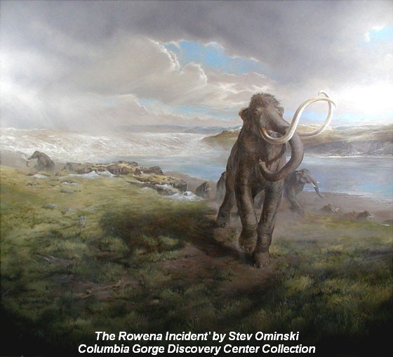
The IAFI Store is primarily an online business, offering informative maps, books, DVDs and pamphlets featuring numerous local features related to the Ice Age Floods, as well as art prints by Oregon artist, Stev Ominski, branded baseball caps, tee-shirts and decals. The store accepts checks, cash, credit card or PayPal payments. The store is run by a volunteer overseen by two board members. We learn about new offerings from publishers, authors, and member suggestions. Those suggestions are reviewed and approved before being added to the store inventory, as part of our attempts to offer a more complete and accurate story of this fascinating piece of geological history. More than ninety percent of sales are online through our website, while the remainder are done by phone, email, or on-site sales at IAFI meetings and field trips, as well as festivals and conferences. The store provides profits from its yearly sales to the Institute to help further its educational and outreach goals. Several chapters run a “Store in a Box” for a share of the profits from sales of a limited amount of merchandise provided by the store. We do not normally handle international sales due to the prohibitive cost and paperwork of international shipping. Patty Hurd, the volunteer who runs the store, says, “The job is usually enjoyable, and I have had the opportunity to meet some new friends, re-establish links with some old ones, and even help one or two international visitors get more personalized and in-depth information from members in the areas they wanted to explore in our country. All in all, it has been a blessing.”
Spokane’s Snowy Ice Age Floods Playground

Families continue to visit Spokane’s Riverfront Park Ice Age Floods-themed Playground on the north bank of the Spokane River even when there is snow and ice on a cold 22 degrees Saturday! It has been very popular since its opening in May, 2021. The playground, covering 40,000 square feet on the Riverfront’s North Bank, is designed to help people learn about the events that shaped our region while they play and enjoy a 3-story Columbian slide tower, Glacial Dam splash pad, a log jam climber, an alluvial deposit fossil dig, and more. In this video the architects describe their realization of the vision for the park, and it shows how people are using and enjoying the new playground.
Mammoth and Horse DNA Rewrite Ice Age Extinctions
New research reveals the ancient animals survived some 8,000 years later than previously thought Frozen soil samples collected around a decade ago are rewriting our understanding of iconic Ice Age animals like the woolly mammoth. The soil samples were pulled from Canada’s permafrost in the early 2010s, but no work on them had been published until recently. A new analysis of the DNA samples reveals that woolly mammoths, wild horses and steppe bison were around as recently as 5,000 years ago—some 8,000 years later than previously thought, according to a study published this week in Nature Communications. Scientists reconstructed the ancient ecosystem using radiocarbon dating of plant material trapped in the soil in combination with microscopic genomic sequences from animal species. Their results showed something unexpected: Large mammals like mammoths and horses were already on the decline before the climate warmed. The scientists found evidence of woolly mammoth and North American horse DNA as recently as 5,000 years ago, which means the animals held out until the mid-Holocene. Excerpted from the Smithsonian Magazine article by Corryn Wetzel
Revered ‘Nick on the Rocks’ Program Collects Pair of Emmy Awards
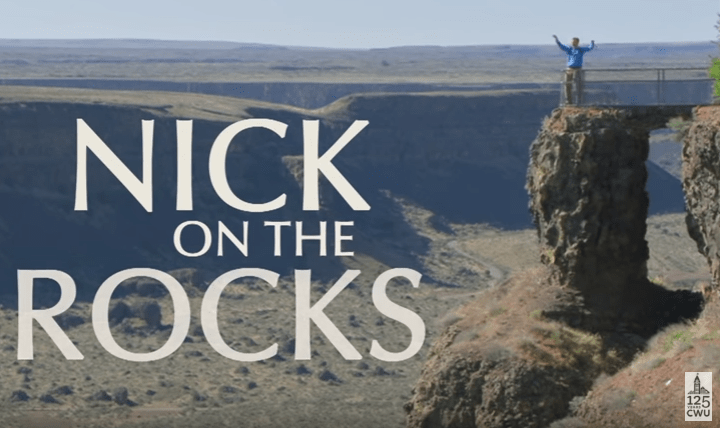
Central Washington University has won two Emmy Awards last summer from the Northwest Chapter of the National Association of Television Arts and Sciences for the popular geological sciences program Nick on the Rocks. The show—which aired on PBS through last year and is still available on YouTube—was recognized for the “Teanaway Tropics” episode in the category Environment/Science, and for the episode “Saddle Mountains Buried in Ash” in the category Informational/Instructional. The awards went to Chris Smart, Producer/Photographer/Editor; Linda Schactler, Executive Producer; and Nick Zentner, Host/Writer in recognition of excellence in broadcast for programs that aired in 2020. Nick on the Rocks highlights the geological history of the Pacific Northwest and presents it in accessible, evocative five-minute videos, hosted by Zentner with Smart providing videography and editing. Zentner has produced scores of short YouTube videos that showcase all aspects of Pacific Northwest geology. His vivid and funny story telling has brought the excitement of massive landslides, cataclysmic floods, and giant lava flows to live audiences throughout the West Coast. Schactler created the series concept at a time when public television stations were searching for short-form video for broadcast as well as online content. Zentner’s extensive experience with the short form, Smart’s video expertise, and the stunning geological formations of Washington created the formula for the popular series. “We wanted a way to reach more people about the wonder of our natural history and the rich quality of CWU’s teaching and learning,” said Schactler. Said Smart, “We’ve worked hard to create a focused concept for each show and to bring enhanced production approaches when needed,” who also noted that working with Nick while capturing video of the natural beauty of the Pacific Northwest has been an exhilarating experience. “Nick is an excellent educator. In just the quick five-minute episodes, he transports viewers millions of years to dramatic geological events that happened right here in our backyard,” he added. More information on the awards is available at www.natasnw.org. For more information or to donate to support Nick on the Rocks, visit cwu.edu/nick. See all episodes of Nick on the Rocks at https://www.kcts9.org/show/nick-rocks/episodes.
October 6th Set as UNESCO International Geodiversity Day

The International Geodiversity Day was established today by the 41st session of the UNESCO General Conference!! From now on, the 6th of October will be an annual worldwide celebration, raising awareness across society about the importance of non-living nature for the well-being and prosperity of all living beings on the planet! The winner of the competition for the International Geodiversity Day logo, Silas Samuel dos Santos Costa, is a student at Universidade Federal do Rio Grande do Norte (Natal, Brazil) and produced the attached logo that can be freely used in all initiatives related with the International Geodiversity Day. Congratulations Silas! The success of this initiative was in no small part due to the breadth of international and national organizations that endorsed the proposal. In particular the support of both IUGS and the Permanent Delegation to UNESCO from Portugal played an essential role in submitted the proposal. The website geodiversityday.org is the virtual focal point for all information regarding this International Day. New social media feeds were launched that you can use to stay updated with plans for International Geodiversity Day: facebook.com/GeodiversityDay twitter.com/GeodiversityDay Now, it is time to start the planning for the 1st celebration of the International Geodiversity Day on the 6th October 2022!
Exploring the Geology of the Gorge with Wildwood Academy

Wildwood Academy, a small alternate school in Hood River, Oregon, contacted the IAFI Columbia River Gorge Chapter with a request for a Gorge Geology presentation for their younger and older student groups. On a couple of days in November, as chapter president, I talked to the two groups from a slideshow covering the last 40+ million years of Columbia River Gorge geology, followed up by short field trips to local sites of geologic interest. As you might imagine, making an hour-long, semi-technical presentation to school kids can be a daunting experience. But these kids were tuned in, attentive, and incredibly responsive, with questions and comments that were right on target. Of course, their teachers had already touched on many elements of Gorge geology, so the kids said they felt the show’s progression through time helped bring it all together for them. And their energy in the classroom and in the field was a wonder to behold. The free-ranging atmosphere at this alternate school was eye-opening and exciting, especially for someone who grew up many years ago in a more structured public school atmosphere. But possibly more important is the feeling that the wonder and excitement of learning and experiencing the world around are alive and well in all the generations following my 75 years. Of special importance to me was a note from one of the parents, “My daughter was one of the kids you spoke to today and she has done nothing but talk about how amazing you were and how she wants to study the Columbia River Gorge area. I have heard nothing else since about 4 o’clock this afternoon!!” It’s a thrill and a real honor to have had that kind of impact.