Kummakivi, Finland’s Balancing Rock, Seems to Defy the Laws of Physics

Our brains are pretty good at physics. For instance, you can watch somebody kick a soccer ball in front of you, and you can run to the spot where you and that soccer ball will intersect, taking into consideration the speed of both you and the ball — so smart! Not only that, we can look at one object balancing on another and tell how sturdy it is without so much as touching it. But sometimes our brains make uneducated mathematical guesses, and one of these is Kummakivi, the balancing rock in Ruokolahti, Finland. If it was up to your brain, Kummakivi — which means “strange rock” in Finnish — wouldn’t exist. It’s a boulder resting on a lump of rock in a position that, to our monkey engineer brains, appears impossible, or at least dicey. Extremely slap-dash and temporary work, at best. And yet Kummakivi sits quietly in its Scandinavian forest, racking up the centuries. Millennia, even. Kummakivi is huge — about 23 feet (7 meters) long. It rests on the tiny, steeply pitched footprint of a smaller mound of rock that rises from the forest floor. The balancing boulder appears to be about to slide right off its perch, but it can’t be moved — at least by human muscles. The reason for this isn’t as mysterious as it might appear: Kummakivi is large, but large things aren’t necessarily more likely to be affected by gravity than small ones. Kummakivi is very rough, which helps it stick in place, and it’s not the same density throughout. The center of gravity looks off when you inspect the balancing rock with your eyes, but it’s actually doing exactly what physics would have it do. But the real question is, how did it get there? People have probably always wondered that, but we’ll never know because it has been there approximately 12,000 years — way before we started recording anything. However, Finnish folklore says that some giants or trolls carried the rock to the forest and balanced it on its plinth. These days geologists say it was deposited by a retreating glacier at the end of the last ice age — and as we know, a glacier is basically the only thing as strong as a giant or a troll. By: Jesslyn Shields | Aug 24, 2022 reprinted from How Stuff Works
Dinosaur-Killing Asteroid May Have Had a Companion

A newly discovered crater suggests a second impact that would have triggered underwater landslides and tsunamis On its own, the dinosaur-killing asteroid had a staggering impact: Wildfires raged across the continents, tsunamis pummeled coastlines and about three-quarters of Earth’s species went extinct. But now, new evidence suggests this massive chunk of rock may have had a partner: Scientists discovered what might be an impact crater off the coast of Guinea that they say dates to 66 million years ago—around the same time as the collision that wiped out the dinosaurs. This second asteroid may have broken off from the dinosaur-killer, known as Chicxulub, or it may have been part of a closely timed impact cluster, according to a new study published in Science Advances. “A lot of people have questioned: How could the Chicxulub impact—albeit a huge one—be so globally destructive?” Veronica Bray, a planetary scientist from the University of Arizona and paper co-author, tells National Geographic’s Maya Wei-Haas. “It might be that it had help.” Researchers discovered what they dubbed the Nadir crater—named after a nearby underwater volcano—in 2020, while examining seismic survey data. “We came across a highly unusual feature,” write Bray and co-authors Uisdean Nicholson and Sean Gulick for The Conversation. “Among the flat, layered sediments of the Guinea Plateau, west of Africa, was what appeared to be a large crater, a little under 10 km wide and several hundred meters deep, buried below several hundred meters of sediment.” Nicholson, a geoscientist from Heriot-Watt University in the United Kingdom, has been interpreting such surveys for about 20 years. But he has “never seen anything like this,” he tells BBC News’ Jonathan Amos. Though scientists haven’t confirmed it was caused by an asteroid, features of Nadir, including its scale, the ratio of height to width and the height of the crater rim, are consistent with an impact origin, write the authors in The Conversation. Additionally, deposits around Nadir look like materials ejected from a crater after a collision. Computer modeling showed that to cause this impact, an asteroid would likely have been about 0.25 miles across and hit an ocean that was more than 2,600 feet deep, per The Conversation. In comparison, the Chicxulub asteroid was likely around six miles wide. Still, this second impact would have been sizable. “The energy released would have been around 1,000 times greater than that from the January 2022 eruption and tsunami in Tonga,” Bray tells BBC News. The hit would have caused shock waves equivalent to a magnitude 6.5 or 7 earthquake, which would have triggered underwater landslides and a series of tsunamis, write the authors. “The discovery of a terrestrial impact crater is always significant, because they are very rare in the geologic record,” Mark Boslough, an earth and planetary scientist at the University of New Mexico, who was not involved in the research, tells CNN’s Katie Hunt. “There are fewer than 200 confirmed impact structures on Earth and quite a few likely candidates that haven’t yet been unequivocally confirmed.” To verify that Nadir was truly formed by an asteroid strike, as well as find a precise date for the collision and determine its connection to Chicxulub, scientists will need to drill into the formation and collect samples. The team has already applied for emergency funds for this additional research, per National Geographic. The drilling could also give scientists clues about how life on Earth responded to the impact. “Part of the Nadir drilling goal is to analyze the sediment that was deposited onto Nadir over time,” Bray tells Inverse’s Kiona Smith. “When did life recover? How?” Smithsonian Magazine article by Margaret Osborne
How Has Your Address Moved Over the Past 750 Million Years?

Some 240 million years ago, an enormous supercontinent known as Pangea encompassed nearly all of Earth’s extant land mass, Pangea bore little resemblance to our contemporary planet, but thanks to a recently released interactive map interested parties can now superimpose the political boundaries of today onto the geographic formations of yesteryear—at least dating back to 750 million years ago. Ancient Earth is an interactive Map tool that enables users to home in on a specific location and visualize how it has evolved between the Cryogenian Period and the present. The tool behind this millennia-spanning visualization, is the brainchild of Ian Webster, curator of the world’s largest digital dinosaur database. Webster drew on data from the PALEOMAP Project—spearheaded by paleogeographer Christopher Scotese, the initiative tracks the evolving “distribution of land and sea” over the past 1,100 million years—to build the map. Users can input a specific address or more generalized region, such as a state or country, and then choose a date ranging from zero to 750 million years ago. Currently, the map offers 26 timeline options, traveling back from the present to the Cryogenian Period at intervals of 15 to 150 million years. Ancient Earth includes an array of helpful navigational features, including toggle display options related to globe rotation, lighting and cloud coverage. Brief descriptions of chosen time periods pop up on the bottom left side of the screen, while a dropdown menu at the top right allows users to jump to specific milestones in history, from the arrival of Earth’s first multicellular organisms some 600 million years ago to early hominids’ relatively belated emergence around 20 million years ago. To switch from one time period to another, you can either manually choose from a dropdown menu or use your keyboard’s left and right arrow keys. Start at the very beginning of the map’s timeline and you’ll see the planet evolve from “unrecognizable blobs of land” to the massive supercontinent of Pangea and, finally, the seven continents we inhabit today. Edited from Smithsonian Magazine article by Meilan Solly, February 15, 2019
Continents Were Created on Ancient Earth by Giant Meteorite Impacts

To date, Earth is the only planet we know of that has continents. Exactly how they formed and evolved is unclear, but we do know – because the edges of continents thousands of miles apart match up – that, at one time long ago, Earth’s landmass was concentrated in one big supercontinent. Since that’s not what the planet looks like today, something must have triggered that supercontinent to break apart. Now, we have new evidence to suggest that giant meteorite impacts played a significant role. The smoking gun consists of crystals of the mineral zircon, excavated from a craton in Western Australia, a piece of Earth’s crust that has remained stable for over a billion years. Known as the Pilbara Craton, it is the best-preserved chunk of crust on the planet… and the zircon crystals within it contain evidence of ancient meteorite impacts before the continents broke apart. “Studying the composition of oxygen isotopes in these zircon crystals revealed a ‘top-down’ process starting with the melting of rocks near the surface and progressing deeper, consistent with the geological effect of giant meteorite impacts,” explained geologist Tim Johnson of Curtin University in Australia. Our research provides the first solid evidence that the processes that ultimately formed the continents began with giant meteorite impacts, similar to those responsible for the extinction of the dinosaurs, but which occurred billions of years earlier.” The work was conducted on 26 rock samples containing fragments of zircon, dating between 3.6 and 2.9 billion years old. The research team carefully analyzed isotopes of oxygen; specifically, the ratios of oxygen-18 and oxygen-16, which have 10 and 8 neutrons, respectively. These ratios are used in paleogeology to determine the formation temperature of the rock in which the isotopes are found. Based on these ratios, the team was able to distinguish three distinct and fundamental stages in the formation and evolution of the Pilbara Craton. The first stage is the formation of a large proportion of zircons consistent with partial melting of the crust. This partial melting, the researchers show, was likely the result of bombardment by meteorites, which heated the planetary crust on impact. The oldest cluster of these zircons, according to the team’s interpretation, was the result of a single giant impact that led to the formation of the craton. The second stage was a period of reworking and stabilization of the crustal nucleus, followed by the third stage – a period of melting and granite formation. This stabilized nucleus would then, much later, evolve to become today’s continents, as did the cratons found on other continents around the world. Many meteorites have pelted Earth in eons past, in numbers much higher than the number of continents. It’s only the largest impacts that could generate enough heat to create the cratons, which appear to be twice as thick as their surrounding lithosphere. These findings are consistent with previously proposed models for the formation of cratons around the world – but constitute, the researchers said, the strongest evidence yet for the theory. However, it’s just one craton, out of around 35 known. To make the evidence even stronger still, the team will need to compare their results with more samples from other cratons, to see if their model is consistent globally. “Data related to other areas of ancient continental crust on Earth appears to show patterns similar to those recognized in Western Australia,” Johnson said. “We would like to test our findings on these ancient rocks to see if, as we suspect, our model is more widely applicable.” Article by MICHELLE STARR, Science Alert,10 August 2022 – The research has been published in Nature.
37,000-year-old mammoth butchering site may be oldest evidence of humans in North America

A 37,000-year-old mammoth butchering site, uncovered in New Mexico, might be the earliest evidence of humans in North America, controversial research finds. Some of the bones at the site show signs of being handled by humans or even being used as tools, which is “some of the most conclusive evidence” yet that humans settled in North America much earlier than experts previously thought, according to the new study. If the team is correct about human activity at the site, it would almost double the amount of time humans have occupied North America. However, determining the exact date that people first appeared in North America has been a controversial subject over the past few decades, and similar studies have been dismissed as inconclusive. Some experts are similarly skeptical of the conclusions the team has drawn from the mammoths’ remains. The new site was discovered on the Colorado Plateau in northern New Mexico, after hiker Gary Hartley spotted a chunk of tusk protruding from the surface. Researchers named the site the “Hartley mammoth locality” in his honor. An excavation of the Hartley site revealed the incomplete remains of two mammoths, believed to be an adult female and a juvenile. Most of the bones were grouped in a large pile, with the adult female’s skull lying on top. By carbon-dating collagen in the bones, researchers estimated the remains could date to between 36,250 and 38,900 years ago. Some of the bones appeared to have been crafted into makeshift knives, possibly used to butcher the mammoths, the researchers said. Other bones showed signs of being broken by blunt-force trauma, possibly from using rocks, which were also found in the pile of bones. There were also puncture marks in some of the mammoths’ ribs, possibly resulting from humans’ attempts to glean at the valuable nutrients inside. Tiny particles found in the sediment surrounding the bones also included crystallized ash from what researchers suspect was a fire, possibly used to cook the mammoth meat as well as other small animals. “What we’ve got is amazing,” said lead study author Timothy Rowe, a paleontologist at The University of Texas at Austin. When did the first Americans arrive? Until the early 2000s, archaeological evidence had suggested that the Clovis people — a group of early humans who can be identified through distinctively shaped weapons — were the first humans in North America, arriving around 13,000 years ago. But more recent finds have revealed that there was likely a genetically separate group of humans, known as pre-Clovis people, living in North America before the Clovis people arrived. It is now firmly established that the pre-Clovis people were the first humans to live in North America, and they can be reliably traced back to around 16,000 years ago, Justin Tackney, an anthropologist at the University of Kansas who specializes in the human settlement of the Americas and was not involved in the study, told Live Science in an email. This time frame suggests that the pre-Clovis people arrived in North America after the end of the Last Glacial Maximum (LGM) — the most recent period when ice sheet coverage across Earth was at its greatest extent, between 26,500 and 20,000 years ago. The melting ice sheets likely provided the pre-Clovis people with an opportunity to cross the Bering Land Bridge, a piece of land that once connected North America and Asia. However, a number of recent contentious studies have claimed that the pre-Clovis people may have dated even further back, potentially to before the LGM. But this idea has been “a much bigger pill to swallow” for most experts because the evidence from these studies is inconclusive, Tackney said. A 2017 study investigating a similar pile of mammoth bones at a site near San Diego revealed that the bones may have been handled by humans and could date back to around 130,000 years ago, suggesting humans may have been around more than 10 times longer than previously believed. However, critics argued that the bones’ unusual orientation and “wear and tear” could also be explained by natural processes and were not definitively human-caused. In 2020, another group of researchers claimed to have found unusually shaped rocks in a Mexican cave that may have been used as stone tools and date to around 30,000 years ago. But another study(opens in new tab), published in 2021, cast serious doubt over whether the shape of the rocks indicated they were human-made. These types of studies can be problematic because the evidence does not definitively point to humans. Instead, humans are just one possible explanation. This means researchers are often creating a narrative to fit the evidence, rather than the evidence clearly pointing to what really happened. “People in our field usually err on the side of caution, and the simplest explanations are preferred,” Tackney said. “In that sense, I am always extremely skeptical of reports from sites like these.” Until now, the most conclusive evidence of a pre-LGM settlement for pre-Clovis people comes from a 2021 study, which revealed a set of 60 bare human footprints uncovered at White Sands National Park in New Mexico. The fossilized tracks date to between 21,000 and 23,000 years ago based on organic material trapped inside the footprints, which suggests pre-Clovis people may have moved into North America before or during the LGM. But this discovery has not been enough to settle the debate. New evidence In the new study, researchers analyzed the bones found at the Hartley site using a number of techniques, including high-resolution CT scans and scanning electron microscopy. These analyses revealed that a handful of the bones displayed signs of being fractured by blunt-force trauma, including, most notably, the adult’s skull. Most of the ribs showed signs of being snapped off the vertebrae and some had puncture marks that the researchers think could have been made by humans to extract fatty marrow from inside the bone, according to the study. At least one rib bone also shows signs of cut-like marks that could have been left by humans. “There really are only
Steamboat Rock
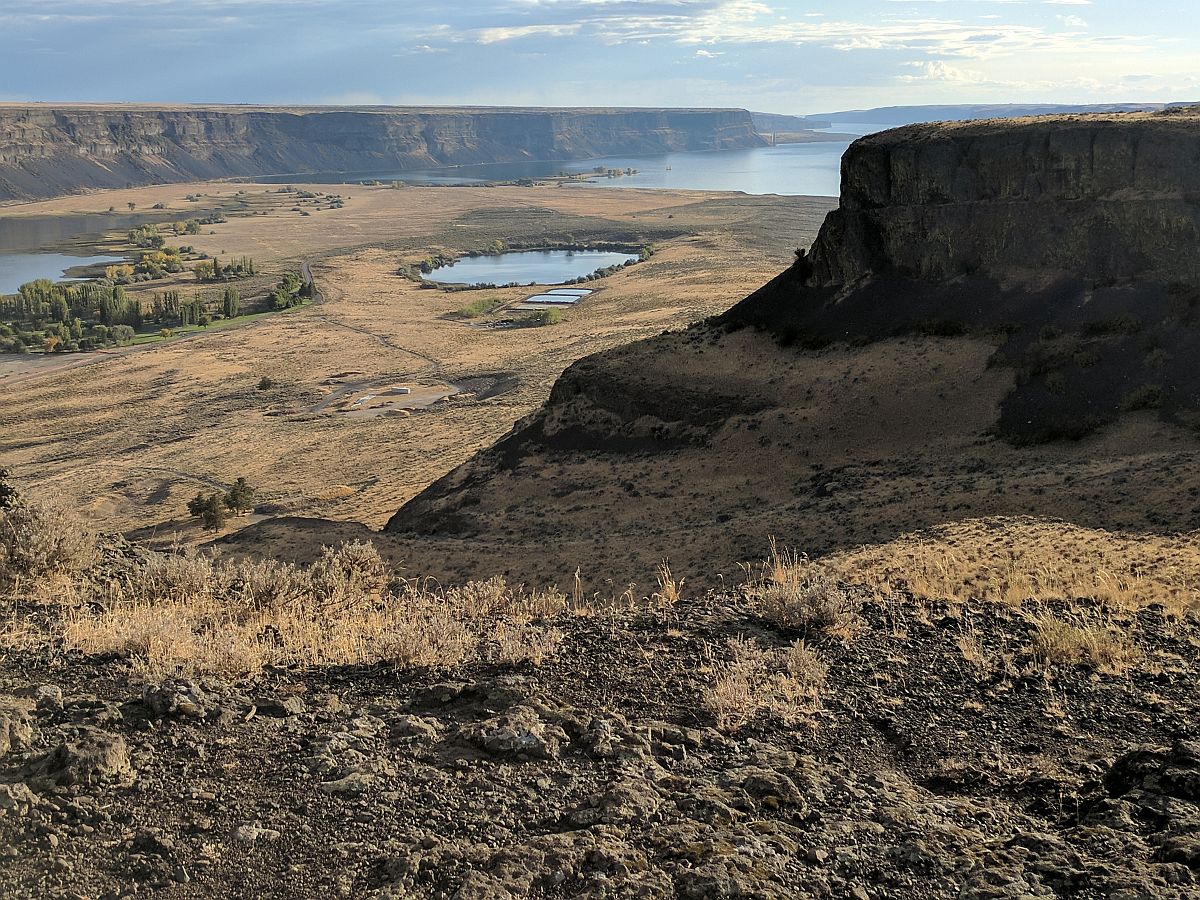
Steamboat Rock lies at the very northern end of the Grand Coulee. At over 1 mile long, ⅔ mile wide, and 800 feet high. The basalt-topped butte standing alone in the middle of the coulee, almost completely surrounded by the waters of Banks Lake is an incredible sight. It was left behind by erosion of both the Ice Age Floods that carved the Grand Coulee, and the Okanogan Lobe of the ice-age continental ice sheet. Because this area is near the thinning outer margin of the Columbia River Basalt extent, it’s easy to see Columbia River Basalt directly overlying older granitic basement from the trails around the base. A steep climb on a well constructed trail leads to the broad top of Steamboat Rock where the views are truly expansive, encompassing a full 360° panorama. It’s also easy to find granitic erratics and glacial till atop the butte that attest to the fact that the Okanagan Lobe overrode Steamboat Rock during the most recent Ice-Age glacial advance. The campgrounds at the State Park are spacious and well laid out. There is easy access to both the trails and to Banks Lake for fishing, boating and swimming. Most of the water in Banks Lake has been pumped up from the Columbia River’s Lake Roosevelt, and impounded by a dam 20 miles south at Coulee City. Banks Lake is a key element in the Columbia Basin Project that supplies water for the verdant agricultural areas to the south in an otherwise quite dry, high desert environment. Some other interesting places to explore in the area include Northrup Canyon, Grand Coulee Dam, and the quixotic Gehrke Windmill Garden just north of Electric City.
Frenchman Coulee
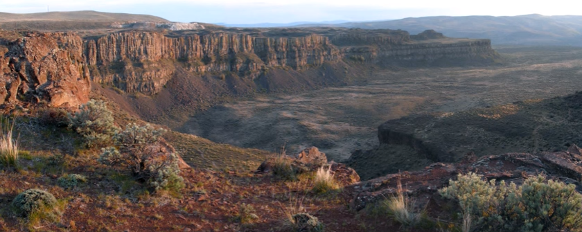
Frenchman Coulee Ice Age Floods National Geologic Trail Frenchman Coulee is a short drive north and west from the Silica Road exit 123 off US-90, along the Old Vantage Road. It is one of the most beautiful features left behind by the great Ice Age Floods. Several of those massive floods, up to 700 ft (213 m) deep, created Frenchman Coulee, its Potholes Coulee neighbor to the north, and scoured the bizarrely eroded surface of Babcock Bench, preferentially eroding weaker rock out of the top of the Grand Ronde Member of Columbia River Basalt. Frenchman Coulee is actually a dual coulee and cataract system, Frenchman Coulee and Echo Basin, separated by a remnant rock blade that sports tall basalt columns attracting rock climbers like bees to flowers. The Feathers is probably the most popular climbing area in the region. Hiking trails, some barely discernible, lead along and atop the rock blade, affording spectacular views of both coulees. Frenchman Coulee also has a waterfall in the eastern section of the Coulee that is accessible by foot. Other hiking and biking trails explore the floor of the coulee and continue over 15 miles north along Babcock Bench, perched high above and adjacent to the Columbia River, past Potholes Coulee and on to Crescent Bar. Quick Facts Location: Old Vantage Highway, Quincy, WA 98848 A primarily destination for hikers, mountain bikers and rock climbers with the fascinating rock formations of the Gorge making for a great challenge
Hiking Drumheller Channels

Hiking Drumheller Channels Ice Age Floods National Geologic Trail There are scads of hiking trails all through Drumheller Channels National Natural Landmark. On a cloudy day in early June we took off on a couple of exploratory hikes that were simply amazing. We first proceeded south from the parking lot at Lower Goose Lake, running through late Spring wildflowers, eventually looking for one of Bruce Bjornstad’s geocaches. We wandered over hills and down into deeper valleys, always surrounded by the towering walls of basalt defining that section of Drumheller Channels. Along the way we found an area of apparent Kolk depressions with odd spires of basalt poking up out of the middle of a central mound. Soon we passed through a reedy area that bounded the southern edge of Lower Goose Lake. We continued on south to the edge of Black Lake where the geocache was supposed to be, but after 20 minutes with 4 of us looking in the area of the GPS coordinates, we finally decided the cache was no longer there and headed back. The hike was easy, very pleasant, and mercifully cool due to the cloudy morning. We then drove north across the O’Sullivan Dam, and back south through Columbia National Wildlife Refuge to the W. McManamon Road entrance to Crab Creek Marsh Unit #3 and the Basalt Columns at Drumheller Trailhead, the kickoff point to go to the top of “Nick’s Columns”. Nick Zentner’s videos about the columns are great, but the blooper where his rock hammer falls down between columns is priceless. We just had to see those columns for ourselves, and we weren’t disappointed. It’s interesting how only the columns along the edge are free standing, while those inboard are packed around with sediment. The little rain the area gets probably washed the sediment out of the spaces between the bordering columns. After walking around for a while we made our way back to the car and drove to the Drumheller Channels National Natural Landmark overlook for a final sweeping viewpoint. The entire area is huge and worth several days of exploring, but it’s also pretty easy to have a great time in just a few hours. This is a place you just have to experience. Quick Facts Location: Adams County, Washington 99371
Dry Falls Kayaking

Dry Falls Kayaking Ice Age Floods National Geologic Trail Most Pacific Northwesterners know how awesomely majestic and stunningly beautiful Dry Falls is, if only from the pictures that seem to show up everywhere. If you haven’t been there in person yet you definitely need to make that trek into central Washington. The drive through the lower Grand Coulee, as awesome as it is, is only the teaser for the view from the Dry Falls Visitor Center. But if you really want to get into the majesty, consider taking a kayak down to Dry Falls Lake or Deep Lake, at the base of those monstrous cataracts. The dirt road to Dry Falls Lake isn’t for the faint of heart, and a good, high clearance SUV is recommended. But paddling the lake near the base of those 400 foot high cliffs is worth the effort. Bordered by reeds and accompanied by waterfowl, an hour-long paddle around the lake is leisurely, relaxing, and totally absorbing. And who knows, you might end up in someone else’s fantastic photo of Dry Falls from the Visitor Center. The road to Deep Lake is paved, so it is a much easier place to get to. And the ramp at the lake makes getting in and out pretty easy… just be careful of the slippery algae on the ramp. Once you’re on the lake an hour’s paddle will take you from an area bordered by rolling hills to a section bounded by high vertical walls. Don’t fall out in this area because there’s nowhere to climb out or beach your boat to climb back in. Still, it’s astoundingly interesting to get up close and see the variety of textures in the basalt walls. Of course, you can also do some great hiking in both areas, though climbing the blade takes quite a bit of effort and confidence, but the view is pretty spectacular. Unfortunately, the way back down isn’t any easier than the way up. Choose your route carefully. Quick Facts Location: Grant County, Washington, United States 99371 MANAGED BY:Washington State ParksWebsite: https://iafi.org/go-do/washington/ Dry Falls is a 3.5-mile-long scalloped precipice with four major alcoves, in central Washington scablands. A Discover Pass is required for vehicle access to state parks for day use. For more information about the Discover Pass and exemptions, please visit the Discover Pass web page.
Ginkgo Petrified Forest

Ginkgo Petrified Forest State Park Interpretive Center Ginkgo Petrified Forest State Park is a registered National Natural Landmark, lyng just north of US-90 at exit 136, and west of the Wanapum Lake portion of the Columbia River at Vantage, WA. Established in 1935, it is home to a rare and vast collection of petrified trees. The park covers 7,124 acres, including an interpretive trail, on which visitors can hike and see protected displays of several of the petrified tree species. The abundance of tree species discovered here make it one of the most diverse collections of petrified trees in North America. The trees are thought to have been carried down the flanks of ancient volcanoes from various ecological zones by floods and lahars., and then deposited and buried in an ancient lakebed. Slowly, cell-by-cell, the tree cells were replaced by dissolved minerals in the groundwater, resulting in exact rock replicas of the trees. The park comprises three primary locations. Drive a couple of miles up the Old Vantage Highway to the Ginkgo “Trailside Museum”, constructed by the Civilian Conservation Corps in the 1930s, and recently updated with a new interpretive exhibit. From here, 1.25 miles of the Trees of Stone Interpretive Trail wind past more than 20 petrified logs protected in their original settings with signage about the petrified wood. Birders look for golden eagles, sage thrashers, Say’s phoebes and many other species. Elk and bighorn sheep also frequent this area. A total of 3 miles of hiking trails are at this site. Perched on a cliff face carved out by Ice Age floods, Ginkgo Petrified Forest Interpretive Center overlooks the Wanapum Lake portion of the beautiful Columbia River. The access road is marked by a small sign on Main St. just north of the small town of Vantage. The interpretive center was constructed by the Civilian Conservation Corps during the Great Depression and was later expanded in 1951.The air-conditioned Center museum features a beautiful collection of more than 30 varieties of petrified wood, videos and park volunteers to inform visitors about the history behind this unique and unusual petrified forest. They can also tell about the powerful Ice Age Floods, responsible for the visually captivating surrounding landscape. Outside the Center, visitors can enjoy the day-use/picnic area, view the scenic river, touch petrified wood and learn more about the Ice Age Floods. Ginkgo Petrified Forest State Park is also home to the Wanapum Recreation Area about 3 miles south of US-90, which features 27,000 feet of freshwater shoreline and hosts a 50 site, full hook-up campground, a day use area with a swim beach, and a boat launch. Quick Facts On the Ice Age Floods National Geologic Trail Location: 4511 Huntzinger Rd, Vantage, WA 98950 99371 MANAGED BY: Washington State Parks A Discover Pass is required for vehicle access to state parks for day use. For more information about the Discover Pass and exemptions, please visit the Discover Pass web page.