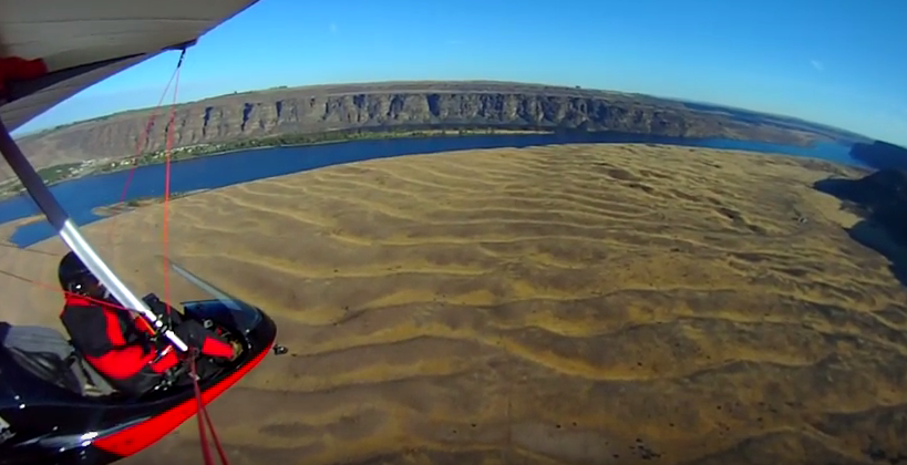
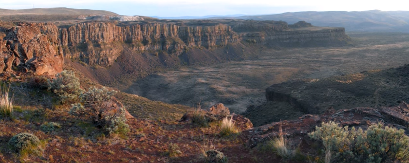
The Great Blade – Bruce Bjornstad Video
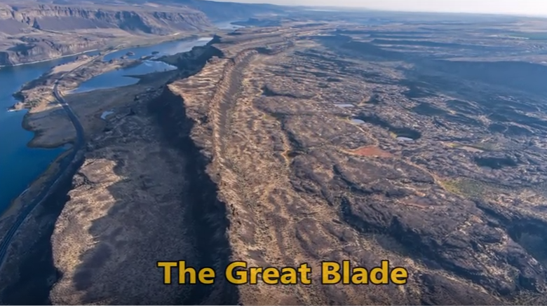
“…there were a few double falls each member of which receded at approximately the same rate, so that the island in mid-channel became very much elongated, like a great blade, as the falls receded and the canyons lengthened.” J Harlen Bretz (1928) A tall, narrow basalt ridge, coined “The Great Blade” by J Harlen Bretz, parallels Lower Grand Coulee east of Lake Lenore. The blade is the product of Ice Age floods that repeatedly rampaged Grand Coulee as recently as 15,000 years ago. Most of the floods appear to have come from sudden outbursts from glacial Lake Missoula. During flooding the coulees on either side of the Great Blade were filled with up to 800 ft turbid water. The largest floods also overtopped the Great Blade, submerging the site under at least another 100 ft of floodwater. On the west side of the blade, where Lake Lenore is located, lies the Lower Grand Coulee, which ultimately migrated 10 miles northward – all the way to Dry Falls. On the east side of the blade is the higher East Lenore Coulee, which migrated a shorter distance (~3 mi) to Dry Coulee. Like a gigantic rib the Great Blade is tallest and narrowest at its south end, widening to the north. The blade extends for almost four miles from where the head of East Lenore Coulee intersects Dry Coulee. In places the blade narrows to as little as 800 ft wide. Video produced by Bruce Bjornstad for Ice Age Floodscapes
Lake Lewis Isles Tour
Lake Lewis Isles, Badger Mt. Centennial Preserve and Skyline Trail Best Observation Points By Auto: 1. Along State Route, SR 240 near mile posts 24-26, and along SR 224 and Interstate, I-82, in Richland and Kennewick, WA. 2. Along I-182 near Road 68 in Pasco, WA. Lake Lewis Isles Trails Off-road trails ascend Badger Mountain, Red Mountain and Goose Hill, located south and west of Richland, Washington. These and two other neighboring hills were mere islands that poked out above Lake Lewis when floodwaters backed up to over 1,200 feet in elevation behind Wallula Gap (Figure 1). Badger Mountain Trails Badger Mountain Centennial Preserve is owned and operated by Benton County of Washington State. It was created as the result of a grassroots campaign led by the Friends of Badger Mountain to preserve the mountain as public open space. The preserve is now home to five trails, accessed via two different trailheads, one at Trailhead Park, and one off Dallas Road (Figure 2). Trailhead Park Location: N 46.238404°; W 119.306286°, parking lot of Trailhead Park located at 525 Queensgate Dr., Richland, Washington. To access this trailhead take Exit 3A (Queensgate Drive South) off Interstate I-182 south of Richland, Washington. Proceed 0.5 miles and turn left (east) onto Keene Road. Proceed 0.6 miles east to Shockley Road (near Bethel Church) and turn right. Follow Shockley Road to the end, where you turn left on Queensgate Drive, and go up the hill to the stop sign, where you turn right on to White Bluffs St. and then turn left into the parking lot. Trail Length / Difficulty: From this trailhead hikers have their choice of three trails – Canyon Trail (1.3 miles / Moderate), Sagebrush Trail (0.6 miles / Easy to Moderate), or Badger Flats Trail (0.4 miles / Easy). Dallas Road Trail Head Location: N 46.242209°; W 119.342810°. To access this trailhead, take Exit 3B (Queensgate Drive North) off Interstate I-182 south of Richland, Washington. Proceed 0.2 miles and turn left (south) on to Duportail Street. Proceed approximately 0.7 miles and turn right (west) on to Keene Road. Proceed another 0.6 miles and turn left on Kennedy Road. Stay on Kennedy Road for 0.6 miles and turn left (south) onto Dallas Road. Follow Dallas Road for 1.2 miles, going under the I-182 overpass and continuing to the top of hill, then turn left onto a gravel road that takes you to the trailhead. Trail Length / Difficulty: From here hikers have their choice of the Skyline Trail (2.9 miles / Moderate), or Southside Trail (2.5 miles / Easy). Skyline Trail offers spectacular views of the Lake Lewis Isles. Warning: Outside of Trailhead Park there is no shade or portable water. Skyline Trail Description (after http://hiketricities.com/badger-mountain-dallas-road/) The trail winds and climbs gradually through virgin sagebrush. As you reach the top of the sagebrush field, you’ll cross over a dirt road that provides vehicles access to the communication towers on top of Badger Mountain. Across the road, you’ll get spectacular views of Candy Mountain and Red Mountain to the west, two of the Lake Lewis Isles. You will also get great views of the lower Yakima Valley, Richland, West Richland and the Hanford Site (a.k.a. Hanford Nuclear Reservation). Following a few switchbacks, you’ll continue climbing up the ridge. You’ll pass a granitic marker where geologists believe temporary Lake Lewis reached its maximum elevation, submerging the Tri-Cities with over 800 feet of water (Figure 1). Here you have a great view of Rattlesnake Mountain, the Hanford Site, and the Hanford Reach National Monument. Continuing up the mountain, you’ll hike through desert grasses, with plentiful wildflowers in early spring. As you reach the spine of the ridge, you’ll again cross the dirt access road. At this point you have a view of the Horse Heaven Hills and Badger Canyon and as well as the lower Yakima Valley. The trail winds around the south or “back” side of Badger Mountain, passing a couple of communication towers, and then splits. Follow the left fork. The right fork will take you back down to Trailhead Park via the Sagebrush Trail. Follow the trail up to the tower and enjoy the view! On a clear day, you can see the Blue Mountains to the east along with the Tri-Cities, Columbia and Yakima Rivers, Hanford and Badger Canyon. On a clear day, you may get a glimpse of Mt. Adams, over 100 miles to the west. You can either retrace your steps or follow the dirt road back to where the upper trail crosses and then take the trail back down. Taken, in part, from On the Trail of the Ice Age Floods by Bruce Bjornstad1 and the hiketricities.com website. Bjornstad, B. N. 2006. On the Trail of the Ice Age Floods: A geological field guide to the Mid-Columbia Basin. Keokee Books, Sandpoint, Idaho.
Grant’s Getaways – Oregon’s Erratic Rocks

This episode of Grant’s Getaways features Lower Columbia President Rick Thompson and the Floods-borne erratics of the Willamette Valley
Ice Age Floods – Giant Current Ripples
Check out this 2-Minute Geology expedition with Nick Zentner and Tom Foster exploring the Giant Current Ripples at West Bar and Camas Prairie. Ice age floodwater 650 feet deep – moving at 65 miles per hour – left Giant Current Ripples along the Columbia River at West Bar! The ripples at West Bar are 20 feet high, spaced up to 100 yards apart. Giant Current Ripples at Camas Prairie, Montana are also described. The Montana ripples helped Joseph Pardee understand that Glacial Lake Missoula had emptied suddenly. Learn more about Glacial Lake Missoula, Lake Bonneville and the Ice Age Floods at http://hugefloods.com/
Lava + Ice + Water = Floods Geology
Floods of lava (Columbia River Basalts) and Ice Age Floods of water (Lake Missoula floods and the Bonneville Flood) are world-famous topics among geologists. To have both sets of floods in the same area means the geology of the Inland Northwest is truly Disneyland for Geologists! The program begins in Lewiston, Idaho where the floods of lava and water are beautifully on display near the mouth of Hells Canyon. Early on, the Columbia River Basalts – eruptions of fluid lava from deep fissures – are featured. The Missoula Floods from Montana and the Bonneville Flood from Utah – the Ice Age Floods – are surveyed at an introductory level. And finally, the interaction between bedrock and fluid dynamics of the floodwater are highlighted through discussion of Ice Age erosional and depositional landforms. Key locations in the Pacific Northwest are featured, including the Snake River Canyon, Grand Coulee, Dry Falls, the Drumheller Channels, Wallula Gap, and the Columbia River Gorge. Tom Foster and Nick Zentner (Central Washington University) had been hiking together in eastern Washington for years. The result? A series of short videos that showcase geological wonders in the Pacific Northwest. This 16-minute video – Huge Floods in the Pacific Northwest – offers an introductory overview of spectacular geologic events that impacted much of Washington, Oregon, and Idaho. More than a dozen “2 Minute Geology” episodes are now available on Nick’s 2-Minute Geology YouTube channel.
Nova – Mystery of the Mega Flood
Monument Valley, the Grand Canyon, Niagara Falls: these ancient wonders show how nature’s forces have shaped the face of our planet on a vast timescale, how great landmarks are the work of millions of years of slow, imperceptible erosion by wind and water. But here, across 16,000 square miles of Washington State, abrupt rips and scars in the landscape defy this explanation. What could have formed these tall canyons and immense dry waterfalls? What could have gouged out these gigantic potholes? Whatever happened, the forces unleashed here created one of the Earth’s most enigmatic landscapes. For more than a century, scientists have been grappling with this geological mystery, descending through thousands of years of Earth’s history in a struggle to uncover, layer by layer, how this landscape was formed. Now the clues point to a sequence of events culminating in a massive natural catastrophe. Explore the features and reasoning that lead to the recognition of the “Missoula (Outburst) Floods” and helped to solve “The Mystery of the Megaflood (Spokane Floods or the Bretz Floods)”
Ice Age Floods’ Features
This is an amazing compilation of extra ordinary photographs that have been expertly labeled to assist the viewer’s understanding of the evidence supporting the creation of the Channelled Scablands in Eastern Washington State, USA. The photographs are panned and zoomed in and out on providing an overview and close-ups of flood evidence. Music playing in the background helps the viewer focus on the information displayed in an unhurried manner. The viewer can stop the screen at any time to give them more time to study the information displayed in great clarity. For teaching, this methodology is suburb! Much better than a regular film or static photos. YouTube slideshow prepared by Bruce Bjornstad, published Dec 8, 2012
Floodscapes Map
The map below shows a growing collection of locations and information about Ice Age Floodscapes (landscapes affected by the Ice Age Floods). Use Ctrl+Scroll to zoom, click-hold to drag the map around, click on markers for details, photos, and links to more information. For an index of sites click the the Expand Index icon (arrow in box icon on the black top bar, left side) or View Larger Map icon (box shaped icon on the black top bar, right side) Though we try to maintain accuracy, the Ice Age Floods Institute does not guarantee the accuracy of any information represented on this map. This map is provided solely as an educational service to our members and guests. Floodscape Articles
Glacial Lake Missoula – A Portrait
In this video Tom Davis flies you back some 13,000 years ago to see and hear what the landscape of Glacial Lake Missoula might have looked and sounded like. A virtual recreation of the magical ice-age lake and its catastrophic floods. Produced by Tom Davis, GLM Wine Company, Blaine, WA minutes)
Missoula Flood Rhythmites
Lake Missoula filled many times and emptied catastrophically in many Missoula Floods. Rhythmite sequences [a series of repeated beds of similar origin] at numerous localities provide this evidence: slack-water rhythmites in backflooded tributary valleys below the dam indicate multiple floods, and varved rhythmites in Lake Missoula attest to multiple fillings of the lake. Below the dam, most slack-water rhythmites are graded beds deposited by flood bores surging up tributary streams. They grade upward from coarse sand and gravel to silt, with occasional ice-rafted erratics. The tops of some rhythmites are marked by thin paleosols, or buried soil horizons, which indicate a period of subaerial exposure. Thus, each rhythmite represents a separate flood event, and each deposit records multiple floods. The most complete record occurs at Sanpoil Valley, an embayment on the north side of Lake Columbia, where varved rhythmites document 89 flood events, with the period of time between floods initially increasing to a maximum of about 50 years and then decreasing to less than 10 years. Thousands of varves were deposited in Lake Missoula. At the best-known Ninemile locality near Missoula, about 40 rhythmites consist of varves overlain by a sand/silt layer. The varves were deposited on the floor of Lake Missoula, and the sand/silt layers represent subaerial exposure and deposition in a stream. The number of varves in each rhythmite varies from 9 to 40, decreasing regularly upward, and the total number of varves is just less than one thousand. An interpretation of these data would suggest: [1] Lake Missoula filled and emptied [in a catastrophic flood] about 40 times, [2] it took 9 to 40 years to fill the lake, each successive lake requiring less time, and [3] the process was repeated over a period of about one thousand years. Because Ninemile is about in the middle of the very long lake, the record here would not provide a complete history of the lake. Correlating Ninemile with the downstream record would suggest these events were in the latter half of the entire flood history.