
Exploring the Geology of the Gorge with Wildwood Academy

Wildwood Academy, a small alternate school in Hood River, Oregon, contacted the IAFI Columbia River Gorge Chapter with a request for a Gorge Geology presentation for their younger and older student groups. On a couple of days in November, as chapter president, I talked to the two groups from a slideshow covering the last 40+ million years of Columbia River Gorge geology, followed up by short field trips to local sites of geologic interest. As you might imagine, making an hour-long, semi-technical presentation to school kids can be a daunting experience. But these kids were tuned in, attentive, and incredibly responsive, with questions and comments that were right on target. Of course, their teachers had already touched on many elements of Gorge geology, so the kids said they felt the show’s progression through time helped bring it all together for them. And their energy in the classroom and in the field was a wonder to behold. The free-ranging atmosphere at this alternate school was eye-opening and exciting, especially for someone who grew up many years ago in a more structured public school atmosphere. But possibly more important is the feeling that the wonder and excitement of learning and experiencing the world around are alive and well in all the generations following my 75 years. Of special importance to me was a note from one of the parents, “My daughter was one of the kids you spoke to today and she has done nothing but talk about how amazing you were and how she wants to study the Columbia River Gorge area. I have heard nothing else since about 4 o’clock this afternoon!!” It’s a thrill and a real honor to have had that kind of impact.
Ice Age Floods for Southside Elementary 4th Graders

For Coeur du Deluge Chapter President Tony Lewis, an opportunity to lead a Sandpoint 4th grade class in a learning unit on “how Idaho landforms were created” came up suddenly on Oct. 8th. Terese Luikens, the 4th Grade Teacher at Southside Elementary School had 19 students wanting “an actual field trip where you can show and tell us about how glaciers formed some of our lakes.” 3 days later Tony was in front of Mrs. Luikens’ 19 excited and exuberant students, struck by how 4th graders react to rocks and a guest presenter. Hands were up, even before his “Landforms of North Idaho: How They Were Formed and What Caused Them” presentation started. How can you NOT be swept up in their enthusiasm and amazed by their unending questions, some of which are actually related to the topic? They were more excited when he left their school than when he had arrived, and the field trip was happening two days later! Unfortunately, the weather didn’t cooperate. It was cold and windy with a chance of rain when they met at the Pavilion at City Beach in Sandpoint, ID at 10 AM. Were these 4th graders put-off by a “little” inclement weather? Of course not, but they did seem disappointed when told that they were not allowed to go swimming. Hands up again, asking questions, wanting to show where they lived, where we were and where we were going on the maps and images Tony had. After an hour reviewing what was talked about on Monday, with more information about David Thompson, the Ice Age Floods, glaciation and the Purcell Trench and how different lakes (Round, Cocolalla, Mirror and Pend Oreille) were formed, we all loaded up for a drive through the bottom of the Purcell Trench, the Pack River Delta and finally to the Geologic Overlook just one mile east of Hope, ID. Before leaving the bus, the students were given their boundaries and they abided. Although the clouds covered some of the scenes, we could see the steep-faced Green Monarch Mts. where the Purcell Trench Lobe glacier divided into four sub-lobes. One of the sub-lobes went up the Clark Fork River, plugging up the drainage basin and causing Glacial Lake Missoula. Another lobe moved southward, deepening the basin now occupied by Lake Pend Oreille. The students seemed to enjoy viewing the wide-expansive scene of ‘the place where the Ice Age Floods started’. The field trip ended when it started to rain, and the drive back to Sandpoint was uneventful, although I was admonished, in a nice but serious way, for walking up and down the aisle because it was dangerous and “I might break my back!” I agreed and took my seat. It was a fun learning experience for me, and I hope it was for them also.
Ice Age Floods Institute at GSA Convention

In August the Ice Age Floods Institute was offered an opportunity to share an exhibitor booth with the Tualatin Ice Age Floods Foundation (TIAFF) at a major geological conference, the October 10-13 Geological Society of America (GSA) Convention in Portland, OR. This gave IAFI an opportunity to present the Floods Story and educate a worldwide assemblage of geological professionals, researchers, and students, many of whom were not even aware of the Floods or their immense scope. The IAFI Board jumped at this opportunity, approving the registration cost and putting the booth development in the hands of the Columbia River Gorge Chapter President and IAFI Webmaster, Lloyd DeKay, aided by IAFI Membership Secretary, Sylvia Thompson, who also represented TIAFF along with Dr. Scott Burns of Portland State University. With Dr. Burns influence, we were able to acquire a corner booth space very near the main GSA area that ensured a good parade of participant traffic past our booth. We used 3D modeling software to design the booth to scale, then began assembling the materials for the booth. We used QGIS software, with assistance from Stacy Warren of Eastern Washington University, to develop a new map that highlighted the Floods paths, various glacial and temporary lakes along the floods path, as well as the final resting place of much of the sediment eroded by the Floods on the Astoria Submarine Fan. We then printed the map and other images, purchased, trimmed and covered 2” foam insulation boards for display walls, borrowed tables, made table covers, and gathered IAFI Store materials for sale. The day of reckoning came Oct. 8th, when we moved everything to the Oregon Convention Center and set it all up. The Exhibit Hall opened at 5:00pm and we began telling the story that would repeat many times over the next 4 days to people from around the world. We talked with relative locals (WA, OR, ID, MT, NV and CA), people from other parts of the US (at least AK, AZ, UT, CO, TX, AR, IA, KS, KY, IL, MN, WI, LA, GA, NC, SC, AL, FL, NJ, NY, MA, NH, VT, RI, CT), and several countries (including Canada, Finland, Holland, UK, Italy, Morocco, Zimbabwe, India, China, Australia, Columbia, Mexico, and Costa Rica). In all, there were 2,700 in-person participants this year. Our booth was one of the most popular and usually had 2-5 people at a time looking at the displays. Geologic luminaries such as Vic Baker, Richard Waitt, Scott Burns, Bruce Bjornstad and Nick Zentner also stopped by, attracting even more visitors to the booth. We gave away National Park Service, IAFI and TIAFF brochures and we sold books, maps, hats and t-shirts as well as our packets of chapter brochures. Though it involved a lot of time and work for the members and volunteers who manned the booth, we feel it was well worth the effort to educate and spread the Story of the Ice Age Floods. Many thanks to IAFI members Lloyd DeKay, Sylvia and Rick Thompson, and TIAFF volunteers Jerianne Thompson, Yvonne Addington and Linda Moholt for helping make this effort a stunning success. And we now have materials and experience that will serve well for future professional, educational and general public events like this.
Riverfront Park’s New Ice Age Floods Playground

There’s A New Ice Age Floods Themed Playground And Splash Pad At Riverfront Park In Spokane. Riverfront Park is an iconic part of Spokane. Since 1974, this has been a gathering place for families, a venue for all kinds of events, and an all-around fun place to be. And as of May 2021, it’s home to a new Ice Age Floods themed playground. Riverfront Park encompasses 100 acres of land that has quite a history. Native Americans gathered and fished at the nearby falls, and pioneers settled here and started the city of Spokane in the late 1800s. But it was in 1974, when Spokane hosted Exposition ’74, “The World’s Fair,” that this park was really put on the map. Construction for the Ice Age Floods playground officially started in August of 2020, although the crew broke ground a year earlier. With the ground made of rubber and artificial turf, this is a safe place for kids to play. The playground features basketball courts, a wheels park, a splash pad, and multiple play and climbing areas. Read and see more in the article this was excerpted from at https://www.onlyinyourstate.com/washington/riverfront-park-ice-age-playground-wa
On the Trail of High Water Markers for Glacial Lake Missoula
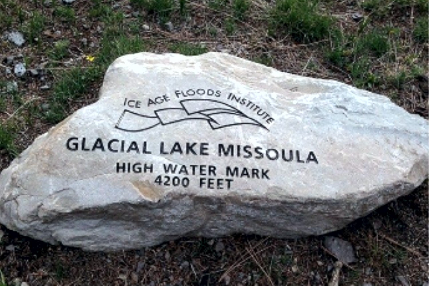
Three more high water markers have been placed by the Glacial Lake Missoula chapter in cooperation with the Montana Department of Transportation and Montana Department of Fish, Wildlife, and Parks. These markers all designate the furthest extension of Glacial Lake Missoula in the Clark Fork River valley near Gold Creek – one is located at a popular fishing access site, and the other two are located at Truck Stops on I-90 in both directions near Drummond at exit 166. The total number of markers is now 10. Five of these are located on popular trails in Missoula – two on Mt Jumbo, two on Mt Sentinel, and one on Mt Dean Stone. These are most easily reached by separate hikes involving a short but relatively steep climb with a panoramic view of Missoula and surrounding mountains. Theoretically they could all be reached in a single day on one long and difficult hike by connecting trails and city streets. We are not aware of anyone who has been able to do that but might want to issue it as a challenge. The other markers in addition to the three at Gold Creek locations are all within a short drive from Missoula up the Bitterroot and Blackfoot/Clearwater drainages of the Clark Fork River to Ovando and Lake Como. These are beautiful valleys surrounded by high peaks Ovando is a popular stop for bicyclists; Lake Como has a swimming beach and a fairly level trail around the lake. Additional locations are being considered The locations and GPS coordinates of these markers are listed on the IAFI interactive map, and they are also individually listed and pictured on the Glacial Lake Missoula chapter website – GlacialLakeMissoula.org – under Local Highlights. The markers are all identified by Glacial Lake Missoula wording with the IAFI logo and the high water elevation, but only those placed by the Montana Department of Transportation have explanatory signage.
Spokane Riverfront Park IAF Playground – Public Opening May 21
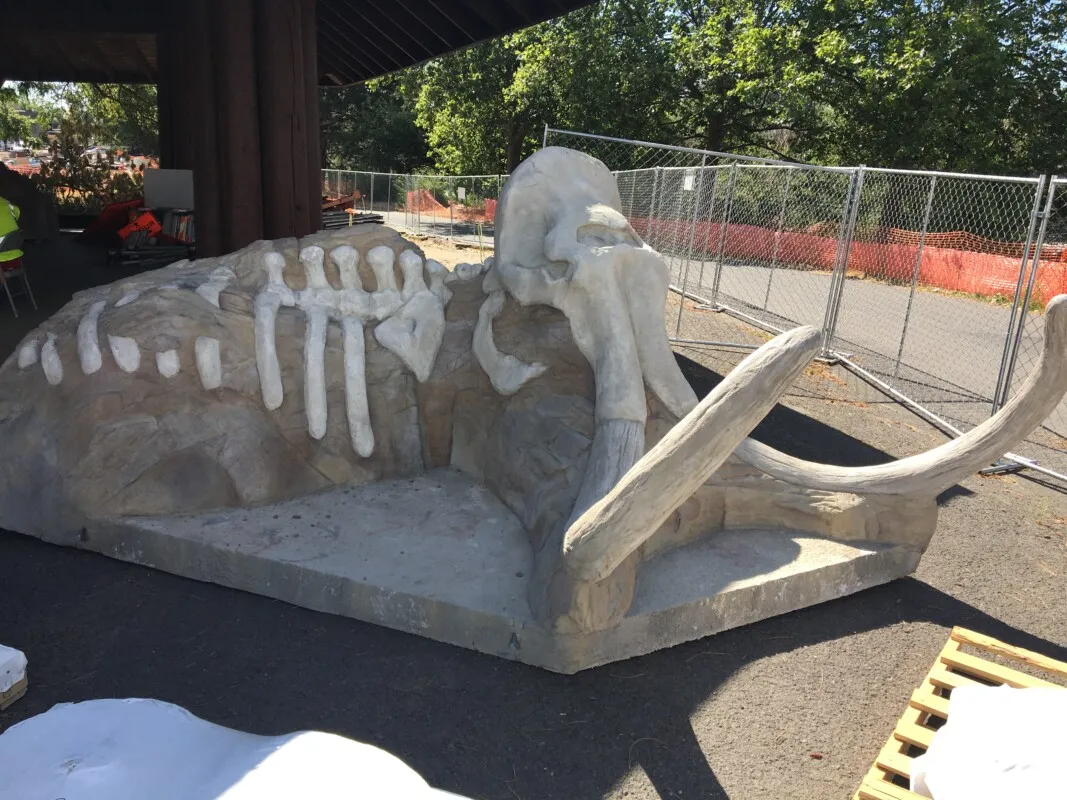
There will be an Invitation-Only Grand Opening of the Ice-Age Floods Playground in Spokane’s Riverfront Park on Friday, May 21st from 11:00 to noon. Then playground will the be open to the public beginning at noon on Friday. All ages are welcome! Click here for more information. The “soft ”pavement has been poured, including some mammoth tracks leading to various features. The Flood Fall is spectacular & will be sure to elicit many screams of delight. The present educational texts & images are temporary. The permanent ones will be installed at a later date.
Lake Lewis Supports Interpretive Signs on Candy Mountain

The Lake Lewis Chapter has been supporting the Friends of Badger Mountain and the Benton County Parks Department with interpretation kiosks, panels, markers, and signage for the Badger Mountain Centennial Preserve and Candy Mountain Preserve (both Benton County Parks), since their inception in 2005. The latest efforts were to help fund, design and locate three Ice Age floods related interpretive signs along a 1.2-mile interpretive loop trail on Candy Mountain. These signs describe the process and history of Ice Age flooding in this area (Figure 1), and the main line of evidence (erratics) that can be seen along the trail (Figure 2). This was the culmination of a nearly two year effort, that was completed in May 2020. Many thanks to Bruce Bjornstad, George Last and Chris Barnes for their efforts. New interpretive signage is being prepared for installation along Badger Mountain’s Canyon Trail. Efforts are also under way to complete the Little Badger Mountain Preserve, the next stage for a vision of trails connecting four of the Lake Lewis Isles (Little Badger, Badger, Candy, and Red Mountains).
Puget Lobe Chapter Lectures On-line

The Puget Lobe Chapter will post recordings of our presentations on YouTube. There are members of the Chapter who can’t make a presentation, but who would like to view our lectures after the fact.. Others may want to review portions of the presentation to answer questions. To accommodate our members, many of our presentations are recorded. The library of past Puget Lobe IAFI lectures is hosted on our YouTube channel, which can be accessed through the Puget Lobe IAFI YouTube Channel: https://www.youtube.com/channel/UCdIqmi3j3uwX2GKvXM1a_2g
LaCrosse Heritage Museum and Ice Age Visitor Center Moving Forward!

With strong community support, in-kind pledges from local volunteers and businesses, recently awarded grants from the Port of Whitman and Whitman County, and a major state grant request in the hopper, the historic rock houses of LaCrosse are soon to get a major face-lift. Three years ago, LaCrosse Community Pride leaders and local businesses renovated one of the crumbling old rock bunkhouses, built during the Great Depression of boulders left behind by glacial floodwaters. That project showed the historic rock buildings could be saved and provided temporary quarters for displays of the Ice Age Floods Institute and the Whitman County Library, partners in the project. Next up? The old rock service station will be transformed into a Heritage Museum and Ice Age Visitor Center. The bunkhouses, two more of which will be renovated, will provide more room for exhibits, a business incubator and overnight lodging. Lloyd Stoess and the Palouse Falls chapter will share our remarkable geologic history. The National Park Service and its National Natural Landscape program leaders have been interested in helping, too. We’re planning to break ground on the project this fall. The LaCrosse Community Pride team thanks Lloyd Stoess and all of you, for steadfast support of this ambitious endeavor. This is a two-year project that will require many hands to complete. If you are interested in learning more or seeing how you can help, please contact Peggy Bryan (pegandpetebryan@yahoo.com) or Alex McGregor (alex@mcgregor.com). Submitted by Leslie Druffel UPDATE: On the state Heritage Capital projects, Alex McGregor reports that we ranked 12th out of 40 applicants and received all positive comments from the judges and that no other project prompted this kind of excitement and curiosity.
4th Badger Mtn Interpretive Sign Installed

Friends of Badger have completed installing the 4th interpretive sign about Lake Lewis Isles on Candy Mountain – one more to go, plus three more for Badger Mountain. Lake Lewis was a temporary lake that repeatedly formed during the Pleistocene Epoch as Ice Age flood waters (mostly from Glacial Lake Missoula) backed up behind a constriction at Wallula Gap. The Lake Lewis Isles name is given to several basalt hills south and west of Richland, Washington, whose crests stuck up above the maximum flood level (1,200 -1250 feet) of temporary Lake Lewis, making them islands. These temporary islands include Badger Mountain, Candy Mountain, Goose Hill, and Red Mountain. Only the top 380 feet of Badger Mountain poked out above Lake Lewis. Icebergs and other floating debris (such as mammoth carcasses) drifted into quieter waters and ran aground along the shorelines of these islands, leaving behind giant boulders of exotic rock types (erratics) from up to several hundred miles away. The scene of Lake Lewis, with its temporary Isles protruding out of the lake and occasional icebergs carrying erratics, can probably be best be imagined from one of the Badger Mountain or Candy Mountain trails, or along Interstate Highway I-182 as it passes through Goose Gap approximately 3 miles southwest of Richland. We encourage you to explore the trails and imagine the vistas of recurring temporary Lake Lewis. Our interpretive signs will help you peek into the distant past and the incredible Ice Age Floods story.