IAFI Booth at WSTA-CSTA Conference in Wenatchee

Ken Lacy of the IAFI Wenatchee Chapter hosted an information booth at the 2022 Washington Science Teachers Association Conference on Oct. 14-15 in Wenatchee, WA. His was the first use of a new table-top display that we recently developed for conferences, meetings and conventions. Ken felt the display,with its impressive graphics, showing maps and images of Ice Age Floods features, attracted a lot of interest and attention and fostered great opportunities to further engage with the conference goers as they came in for a closer look. He felt there was a high level of interest in the Ice Age Floods topic and people were keen to learn more about the floods, which led to many good conversations. It also gave Ken and opportunity to talk to as many as 10 ESD Science Coordinators about our project to provide 4th Grade level education materials about the Ice Age Floods. Their response was uniformly that this idea would not be well received because there was no time available for additional non-formulary classes. One of these Science Coordinators suggested it might be possible to combine our Floods program with an existing program, such as Language Arts, by presenting Floods information and having the students “prove” the existence of the floods by listing facts that supported this hypothesis. In another discussion with a retired school administrator about the issue of available time for our 4th Grade Floods program, she cited two examples of havin had to turn down outside offers of valuable educational programs because there was just not enough class time available for those programs. However, when Science Coordinators and teachers were asked about the idea of having IAFI people either conduct classes themselves or help the teachers develop such a class, the response was quite positive. The different response to the idea of our 4th Grade Floods program and the proposal for individual classes is significant in terms of class-time and preparation required. A single class session can often be fit into the schedule, but a multi-class program may cut too deeply into the time needed for required cirricula. Still, there are several sections in the Washington State Fourth Grade Curriculum that can support the inclusion of our proposed Ice Age Floods program. It will therefore be necessary for IAFI to work with the ESD Science Coordinators in each school district to get their support for the inclusion of our project.
Puget Lobe Chapter Origins – A Brief History

The Puget Lobe Chapter of the Ice Age Floods Institute had its origins in Wenatchee in 2007 during the Institute’s annual field trip. While riding in the tour bus, long-time member Mark Sundquist informally suggested to some nearby Seattle area members the possibility of starting our own Seattle Chapter. The idea was met with an enthusiastic response. Some members had been making the long drive over to Wenatchee from Seattle to attend meetings. There was also a recognition the Seattle had a tremendous amount of ice age geology of its own to offer. Later during the field trip Mark mentioned the conversation to former Institute president Dale Middleton. Dale liked the idea and thought it was worth pursuing. During the fall of 2007 Dale and Mark had a series of meetings to lay the groundwork for establishing a Seattle chapter. Dale’s years of experience as Institute president, familiarity with Institute business, and attention to detail were invaluable. He also had an encyclopedic knowledge of the ice age floods, a love for geology, and great dedication to the work of the Institute. He had a list of greater Seattle area contacts from his work as Institute president and this list formed the genesis of the Seattle chapter’s mailing list. On December 3, 2007, a well-attended organizational meeting of the Seattle chapter was held at the Lynnwood library. Chapter officers were elected with Mark serving as president and Dale serving as vice-president. By-laws were adopted and the name Puget Lobe was selected. By a strange coincidence, during this time the Chehalis River, the ice age outlet for the Puget Lobe drainage, experienced record flooding. In January of 2008 the first regular meeting of the Puget Lobe Chapter was held at the Shoreline library. The meeting was again well-attended with Dale warmly greeting the arriving attendees many of whom he knew from his previous work on behalf of the Institute. Gene Kiver gave a program on the ice age floods. In July of 2008 the Puget Lobe’s first field trip took place. It included presentations on the recessional phases of the Puget Lobe and the Carbon River Glacial Outburst Flood, and tours of the Mima Mounds and Thurston County’s Glacial Heritage Preserve. In the fall of 2008 the Senior Center in Edmonds was procured as a regular meeting place for the chapter. With some members arriving from northern Puget Sound, some from southern Puget Sound, and some by ferry from across Puget Sound the central location adjacent to the ferry dock was convenient. Mark served several terms as president followed by several terms by Dale.
Front Porch: Water etches interesting stories on landscape

I have always loved the ocean. I spent my growing-up years in, on or at least somewhere near the Atlantic Ocean and its various bays. The feel of ocean water, its movement, how it smells and all the amazing life that it supports – wonderful. And whenever I looked over the ocean’s horizon, it wasn’t scary, but rather full of potential for what was just beyond what I could see. When I moved to Spokane – clearly, no ocean, but lots and lots of freshwater lakes and rivers. I have spent I can’t tell you how many of my adulthood hours, swimming in Lake Coeur d’Alene, Lake Pend Oreille, Priest Lake, etc. And sailing. And walking along riverbanks. And tossing sticks into whatever body of water, fast moving or still, that was before me, for our dog to fetch. Water is wonderful. As a young bride, newly relocated to Eastern Washington, lo those many years ago, I took my first drive to Seattle with my husband. Heading up the Sunset Hill, passing Four Lakes, then Fishtrap, then … yikes. Where did the water go? There was a long stretch – broken up briefly by Sprague Lake and Moses Lake – of what was the thirstiest landscape I’d encountered. It wasn’t until we crossed the Columbia River and drove up and past the Vantage Grade did I begin to see deciduous trees and bigger leafy plants that suggested the rainfall amounts required to support them. It got lush and humid and wet as we drove west. We were heading to … water! I just endured that unappealing stretch of land between Fishtrap and the Columbia over a number of years driving back and forth to Seattle. Not only was it dry, it was essentially treeless. One friend of like mind said it was best just to drive through there at night because the view would be just as interesting. So much for being young and stupid. It was still kind of dry for my taste, but I began to appreciate how the sunlight hit the terrain at different times of year and in different weather conditions. It still wasn’t water, of course, but it kind of grew on me. It’s hard to live in this neck of the woods and not learn about the wonderful Columbia Basin Project that brought irrigation to east-central Washington (ah, water!), which produces amazing amounts of agricultural products for export and to feed us all. But what really sold me on that, to me, foreign scenery was back when I worked at Eastern Washington University and I met the terrific Bob Quinn, professor of geography, who loved the environs of the state’s east side with a zeal and passion I couldn’t possibly imagine. He gave me some information, and I began to read about this landscape I’d so easily dismissed – land that was scoured by massive floods some 18,000 to 13,000 years ago (the last Ice Age), floods from glacial Lake Missoula that carved out the canyons and created braided waterways now known as the Channeled Scablands of Eastern Washington. The floods were cataclysmic, with estimates indicating that 500 cubic miles of water that was 2,000 feet deep, burst forth at 386 million cubic feet per second – all headed this way, and beyond, in one darn big rushing, gushing explosion. And then it built up and did it over and over again. That’s a lot of water. I began looking at the landscape differently as I drove through, marveling at the magnificence of that creation, and saw that it has its own beauty – not to mention a heck of a back story. How ignorant of me to just have ignored all that geologic magnificence because it didn’t fit into my preferred norm. I thought about that again on our most recent drive to Seattle to visit our son. Clearly, I am no longer a young adult full of not-burdened-by-knowledge opinion and attitude, but an older person with a fair number of miles on her and, I hope, a greater realization that everything deserves a second look – and also, that a little research is also a good thing. Because I read a book and some supporting literature, I discovered things that gave me a different set of eyes with which to see a particular section of the world around me. I’m trying still, even in my old age, to keep doing that. Never too old to read a book and learn something. Or to change a mind. The Spokesman Voices correspondent Stefanie Pettit can be reached by email at upwindsailor@comcast.net
Dean Ladd, 1921-2022, RIP

Dean Ladd, Lt. Col., USMCR Ret., and founding member of the Ice Age Floods Institute passed away on August 17, 2022 at the age of 101 at his home in Spokane, Washington. He was born in Spokane and enlisted at 18 in the Marine Corps. He saw intense WWII fighting during combat on Guadalcanal, Tarawa, Saipan, and Tinian. He served with the Second Marine Division as a platoon and company commander. His experiences led him to write his book, Faithful Warriors, to remember his fallen comrades. It was published in 2009 by the US Naval Institute Press. At the time of his death, he was the oldest retired marine. Ladd received a field commission and saw extensive WWII combat in the Pacific with the Second Marine Division at Guadalcanal, Tarawa, Saipan, and Tinian. He was wounded three times, the most seriously during the landing at Tarawa. He received a Purple Heart at Tarawa and a second one at Saipan as well as numerous other honors during his lifetime. Dean returned home after the war and earned a BS degree in Mechanical Engineering from Washington State College (now University) in 1947. His civilian occupation was in engineering and management with Kaiser Aluminum, North American Rockwell and Lockheed Missiles and Space. He was President of the Lockheed National Management Association. Dean and Vera built their dream home in the hills of Spokane Valley. They had three daughters, Kathleen and Michele (twins), and Janet. Dean stayed very active with the Marine Corps Reserve Association and the Ice Age Floods Institute during its creation in 1994. He also was a founding member of the Cheney-Spokane Chapter in 2003. He volunteered extensively with both organizations and was always present at events where he was a friendly greeter and story teller until his health caused him to stay at home and write. Over his lifetime, he wrote three books and 29 manuscripts while pursuing his hobbies of genealogy, Marine Corps reunions, history, and geology. He is greatly missed. Much more information about his life and works can be found at this link: web: http://theworksofdeanladd.yolasite.com Fond memories and expressions of sympathy may be shared at www.HazenJaegerValley.com Written by Melanie Bell, President, IAFI Cheney-Spokane Chapter
Left Behind: a Lake Missoula island insect resident

A rare and unique perspective on the impact of Glacial Lake Missoula on life in the surrounding mountains has been offered by Professor Emeritus Gary Belovsky of Notre Dame. An object of his studies is a previously unidentified shield-backed katydid (Tettigoniidae: Steiroxys sp.) cricket insect, found on what had been Lake Missoula islands in the Mission Valley and in the Mission Mountains. Based on years of field research (since 1978) in the Bison Range and Mission Valley he found that this remarkable insect occurs in the areas that, during the last major ice-age advance, were islands isolated by the surrounding waters of Glacial Lake Missoula. This diurnal large-bodied insect herbivore (1 – 1.5 gram adult females) can attain relatively high densities (0.35/m 2 ) in mountain meadow habitats. This insect can attain even higher densities in drier prairie habitats, but due to high bird predation they do not occur in these more open habitats. Therefore, the more open lower elevation grasslands act as a barrier to the dispersal of these insects between the surrounding mountains that were formerly isolated islands in Glacial Lake Missoula. Another interesting characteristic of this species, is the absence of males, but that’s another story.
Remembering Jim Pritchard

We’re sad to report that James “Jim” William Pritchard of Ephrata, WA, passed away on August 3, 2022. Jim was 95 years of age (born: September 4, 1926), was deeply interested in the Ice Age Floods, and was devoted to and involved with the Ice Age Floods Institute. A fond remembrance: In the fall of 2000, Charlie Mason gathered together anyone from the greater Wenatchee Valley with an interest in the Great Missoula Floods. He had taught adult classes at the Community College and led field trips and had quite a following. At that meeting, Charlie being the perfectionist that he was, held elections, called for name suggestions, took votes for the name Wenatchee Valley Erratics, and subsequently filed for 501-C status, knowing these all would be needed to charter the first IAFI chapter. The following spring, he and I attended the IAFI spring meeting (there were 2 board meetings every year back then), held at the Moses Lake Chamber of Commerce. Charlie and I presented everything he knew was needed, and the then-IAFI President, Dale Middleton, put to a vote that we would become an interim chapter. Charlie argued there was nothing more our group needed to do to become an actual chapter. It was argued for 20 minutes that we had to be an interim chapter first. After much debate, Jim Pritchard had had enough, quite forcibly told everyone to ‘shut up’, pointed out that Wenatchee was the first to file to be a chapter so set precedent, and put it to a vote. No more argument, and the Wenatchee Valley Erratics Chapter was born. Those of us who worked with Charlie, Dale and Jim over the years, might know that this meeting was much more ‘spirited’ than what I’ve indicated here. When I later joined the board, it was refreshing that Jim, who was treasurer, didn’t mince words, kept the meetings going, and brought a perspective that was down to earth and always well thought out. The Erratics were so lucky when in later years, Jim, and his wife Eula, made the drive from Ephrata to join our chapter meetings.He always brought interesting questions, and wasn’t shy to ask them. Ken and I were lucky to have visited with him last year after the death of Eula. He was still as sharp as ever, and as devoted to the story of the great floods. He will be missed. (by Susan Lacy)
Scholars Trek on the Ice Age Floods Trail

Ice Age Floods Fourth Grade Curriculum Development One of the missions of the Ice Age Floods Institute is to educate young people about the Floods and the influence of the Floods on their lives today. The IAFI Educational Outreach Committee has contracted with the curriculum design firm The Inspired Classroom to produce engaging lesson materials to excite fourth-grade students from across the Northwest about the Ice Age Floods. The curriculum will contain video footage narrated by experts and lesson plans for use by fourth grade teachers in Montana, Idaho, Washington and Oregon. The story, entitled “Scholars Trek on the Ice Age Floods Trail,” will begin with a flyover video of the trail, including Glacial Lake Missoula, the Clark Fork Ice Dam, the Rathdrum Prairie, Spokane Falls, the Channeled Scabland, Lake Lewis, the Columbia River Gorge, Lake Allison, and the deposition of the eroded sediment on the continental shelf at the mouth of the Columbia River. Along the route, students will be introduced to the ways in which the Floods influence society today, including the influence of the Floods on the Spokane Aquifer and on railroad and highway routes across the Pacific Northwest. Funding for the project will come from grants, the IAFI, and from private benefactors. The continued support of IAFI members through membership dues and donations helps fund projects like this. The Education Committee is made up from a sampling of IAFI Board Members and Chapter Presidents from each state: Jim Shelden (Glacial Lake Missoula); Tony Lewis (Coeur du Deluge); Melanie Bell and Consuelo Larrabee (Cheney-Spokane); Gary Kleinknect (Lake Lewis) and Dale Lehman (Puget Lobe.) In the future, the Education Committee plans to work on curriculum materials for middle and high school students. By Dale Lehman, 04/14/2022
Explore the Columbia River Gorge
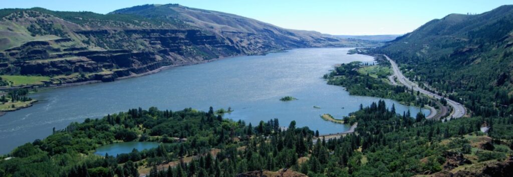
The Columbia River Gorge is an incredibly popular area to visit, and that’s for good reason, the setting is uniquely spectacular. The Gorge encompasses: Easily accessible ecozones that range through boreal conifer forests, oak woodlands, high desert grasslands and alpine environments in only 40 miles, Dazzling viewpoints and scenery, including beautiful waterfalls that cascade over the high basalt ramparts that bound the relatively narrow Gorge and the majestic Columbia River running through it, Mt. Adams, Mt. St. Helens and Mt. Hood, imposing snow-covered stratovolcanoes lying less than 40 miles north and south of the Gorge, Picturesque small towns that are bounded by extensive federally- and state-protected natural areas throughout the length of the Gorge, Abundant recreation opportunities including hiking, road/mountain biking, windsurfing and kiteboarding, whitewater kayaking and rafting, fishing, hunting, alpine/cross-country skiing and snowshoeing, Numerous award-winning wineries and breweries, restaurants and pubs, shops, galleries, museums, parks, hotels and campgrounds, And all this is lying at the back doorstep of Portland, Oregon. The Gorge is also a geologic wonderland, exposing stories about: The 40 million year history of the Columbia River, The series of massive Columbia River Basalt flows 18-12 million years ago, The rise of the Cascade Mountain Range since about 5 million years ago, The passage of numerous, up to 1000 feet deep Ice Age Floods that reshaped the Gorge 18-14 thousand years ago, Tectonic faulting and folding, landslides, earthquakes, forest fires, and The often intertwined lives and stories of the people who have lived here. Of course, with all this bounty the area is also a robust tourist mecca, which can mean limited accommodations for summer crowds. Most attractions are easy to drive to, but bus tours and river cruises are also available. Due to the popularity, some of the iconic attractions now seasonally restrict vehicle access and require permits.
Traveling the Ice Age Floods National Geologic Trail
In September 2021 my wife and I took a trip to see what was new along the Ice Age Floods National Geologic Trail and visit some places we did not make it to in our very first trip in 2004. The IAFI chapter brochures were very helpful in learning what there was to see in each area. We also remembered a preview of the National Parks Service unigrid map brochure that will come out hopefully later this year, so be sure and get one when it debuts. The other excellent tool was the online interactive map on the Ice Age Floods Institute website (https://iafi.org/floodscapes/), where you can click on a spot and see a photo and description of the site. All are great planning tools. We drove to Missoula, Montana and stayed there a couple of days as we made day trips. Our first one was to Ovando to see a granite glacial erratic that the Glacial Lake Missoula Chapter had etched and placed at the high-water line. You will find it at Trixi’s Antler Saloon which is a nice place to grab a bite for lunch. The chapter has a number of these high water markers placed already and have more planned to show the full extent of Glacial Lake Missoula. Unfortunately, due to the smoke from the wildfires we were not able to go to Hamilton to see the 8-ton granite erratics outside Ravaili Museum with four interpretive signs outside and additional displays inside. We drove up to the Paradise Center in Paradise, Montana. We had been there before in 2016 for the fall IAFI field trip and they were just dreaming of what the old Paradise Elementary School could become. They have done a wonderful job of making that dream come true. It was one of our favorite spots on this trip. They have dedicated an entire room to the Ice Age Floods story where an extremely accurate 3-D map of Glacial Lake Missoula has lights installed so you can push a button to light up the edge of the ice lobe and other features. Besides information about the Ice Age Floods, the Center also has wonderful displays about the trains & train yard that used to be in Paradise and the history of the Paradise Elementary School. We went to the Natural History Museum in Missoula and enjoyed the panels and video which told the Lake Missoula Floods story and also about Joseph Pardee, a very important pioneer in solving the mystery of these Floods. This museum also displays an amazing amount of taxidermy showing the wildlife and birds in the region. On our way up to Sandpoint, Idaho we passed through Eddy Narrows. Glacial Lake Missoula drained through this canyon going 80 mph leaving horizontal marks high up on the walls. Previously these were thought to be glacial striations, but Pardee speculated that these marks were from huge boulders as they shot through the Narrows. The Narrows is long with few places you can pull over on Highway 200, so it can be hard to really appreciate its scope. We got a good view from the Koo-Koo-Sint Bighorn Sheep Viewing Interpretive Site which has several interpretive signs that talk about the sheep and the geology of the Clark Fork River Valley. We then went over to Farragut State Park at the southern tip of Lake Pend Oreille to view the beginning of the outburst plain that formed the Rathdrum/Spokane Valley aquifer. Across Lake Pend Oreille is Green Monarch Ridge; the terminus of the Purcell Trench which held the 4,000 ft. ice dam that carved the steep walls. The display at the museum has several interpretive panels. The next day we met Consuelo Larrabee who gave us a personal tour of the 40,000 square foot Ice Age Floods Playground in Riverfront Park in Spokane, Washington. She and Melanie Bell, the president of the Cheney-Spokane chapter, did an enormous amount of work as consultants on this fabulous, themed park. Kids can learn as they play on the three-story Columbian slide tower, Glacial Dam splash pad, log jam climber, an alluvial deposit fossil dig, and more. The park was filled with kids and the adults were enjoying it as much as the kids. We loved watching the excitement of a child as she saw the splash pad water fountains simulate the ice dam starting to rupture and then the cascade of water flooding over the manmade basalt rocks. Along the side of the building are actual basalt columns and the fossil dig led to many exciting discoveries by the children as they dug through the sand to reveal embedded replicas of fossils. Throughout the park are thoughtfully placed benches for people to sit and watch the fun going on around them. There are nine interpretive panels throughout the park adding a wonderful educational benefit to all the fun. This park will be quite a prize for years to come. The next day we drove along Highway 262 to W. McManamon Road to the Drumheller Channels National Natural Landmark. This outlet from the Quincy Basin, with floodwaters going 65 mph eroded not just the topsoil but the underlying basalt which created dramatic channels, basins, potholes and buttes. The viewpoints along the drive had several interpretive panels talking about these wonderful vistas. Since we live in Portland and this trip was to see places we had not recently seen, we skipped over the many wonderful places in the Columbia River Gorge, Willamette Valley & Tualatin. But for your trip, please check out the hundreds of beautiful and interesting sites to see in this region. The last stop for this trip was Cape Disappointment. The Floods debris flushing out the mouth of the Columbia River added substantially to submarine Astoria Fan and sediment cores have shown that ocean currents carried some of this debris all the way down to Cape Mendocino, California. Although not visible from the surface, the Park display has a relief map that shows the Astoria Canyon
Riverfront Park IAF Playground – Information Panels Installed

Permanent information panels have been installed in the Ice Age Floods Playground in Spokane’s Riverfront Park. The panels briefly describe: Fire: Basalt & Columnar Basalt Ice: Cordilleran Ice Sheet Water: Missoula Floods Rhythmites & Varves Erratics & Granite Giant Current Dunes Animals: Columbian Mammoths Animal Fossils The panels have a heavy duty permanent covering, impervious to weather & wanton destruction. They will add greatly to the experience of this special and very popular space. The Ice Age Floods Playground is a spectacular addition to Spokane’s Riverfront Park that is well worth a visit for kids and adults alike.