ESA Maps a Lava Tube for Moon and Mars Expeditions

With all deference to the book and movie “The Martian”, wouldn’t you, as part of an interplanetary expedition, prefer to be protected from the radiation, micro-meteorites and extreme temperature fluctuations of the Moon or Martian surface? Though some of the hazards depicted in “The Martian” are way over-dramatized (the thin Martian atmosphere wouldn’t sustain the depicted raging storms), there are still hazards aplenty on the surface. So why not site your habitat in a cozy lava tube, protected from many of those surface nasties. At least that’s some of the reasoning behind a European Space Agency (ESA) effort to map a portion of Spanish lava tube in centimeter-scale detail as part of the ESA’s 2017 Pangaea-X campaign. Some chambers in the 8 km long La Cueva de los Verdes lava tube are large enough to hold residential streets and houses (or a prototype Martian research station/habitat). In less than 3 hours the cave research team mapped the lava tube using the smallest and lightest imaging scanner on the market and a wearable backpack mapper that collects geometric data without a satellite and synchronizes images collected by five cameras and two 3D imaging laser profilers. While the data is still being analyzed, ESA has released this ghostly fly-thru of a 1.3 km portion of the lava tube. Click the play button and prepare to take a pseudo-trip to Mars. So, the next time you visit a cave or lava tube, especially a large one, imagine yourself in a spacesuit on the Moon or Mars and realize that you’re actually an inner-space explorer. But don’t be too surprised at the creatures you may run into, they’re just other inner-space explorers too.
Grand Coulee Area Hikes Report

Gene Kiver and Bruce Bjornstad led two hikes in the Grand Coulee area. A group of ~30 hikers joined in a moderately difficult hike into the Castle Lake Basin, part of a 4-mile wide cataract complex that extends all the way to Dry Falls. The hike started out near Coulee City by following the Main Canal, which delivers all water from the Columbia Basin Irrigation Project into two siphons that cross Don Paul Draw at the head of Deep Lake. From here the water disappears before flowing two miles, underground, through a pair of tunnels to Trail Lake Coulee. The hike continued by crossing a berm of basalt boulders, dug out for the Main Canal, into the Castle Lake Basin. A descent to the floor of the basin was possible via two steel ladders that crossed the cataract above the Castle Lake plunge pool. From there hikers traversed out to a potholed bench to a spectacular view above Deep Lake Coulee. The next day ~20 hikers joined a ~3 mile roundtrip hike to Giant Cave Arch, near Barker Canyon, along the west side of Upper Grand Coulee. For anyone interested, both these hikes are featured in “On the Trail of the Ice Age Floods: The Northern Reaches” a geologic guidebook published by Bjornstad and Kiver in 2012.
The Columbia River Gorge Eagle Creek Fire – Ruin or Renewal?
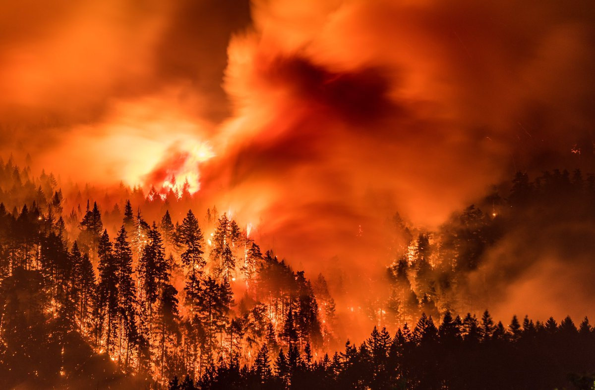
I’ve found there is huge public interest and concern about the catastrophic effects of the Eagle Creek Fire on the Columbia River Gorge. Pictures of ridgeline after ridgeline enveloped in bright orange fire, trees bursting into towering flames, and the choking smoke that filled valleys throughout the Pacific Northwest are truly a hellish image of Armageddon visited on the entire area. But, while the temporary loss of recreational trails and green forest aesthetics, and the increased potential for landslides and falling snags are inconvenient and even somewhat dangerous, the truth is that the recent fires have not ruined the natural areas of the West and the Gorge in particular, but instead have refreshed and renewed them. This past summer I’ve been interpreting geology for a new Columbia Gorge Master Naturalist Program, working beside forest ecology experts who are extremely optimistic regarding the effects of the Eagle Creek Fire. One of those experts, wildlife habitat expert Bill Weiler, writes, “Life will return to burned areas in short order. Fungi are already crawling around in the ashes of the fire, laying the foundation for soil that will support the plants that will constitute the early stage of the forest’s re-growth—a time when heat from the fire and sunlight newly reaching the ground in the absence of a canopy encourages a new crop of plants to firm up the soil structure that will allow gigantic trees to thrive. And ash is nature’s fertilizer. Plant blight, disease and insects are reduced or eliminated by burns. Mineral soil is the compost that Douglas fir seedling roots need to grow. “Dead trees” or snags are full of life.” In a typical forest fire a third of the trees will be scorched and dead, a third will be moderately to severely damaged, and a third will be essentially unscathed. Reports from the Eagle Creek Fire describe that fire as a discontinuous “mosaic burn” with much less devastation even than the typical forest fire burn. There is a broad consensus among scientists that we have considerably less fire of all intensities in our Western U.S. forests compared with natural, historical levels, when lightning-caused fires burned without humans trying to put them out. Early in the 20th century, before fire suppression became the norm, the average annual burn area in the western states was over 25 million acres, compared to a recent average of 4-6 million acres. According to Oregon State University Professor John Bailey, a century’s worth of suppressing wildfire in the United States has created conditions, especially in the West, that will ensure longer fire seasons because of longer, drier and hotter summers. Those conditions point to the need for “actively managed” forests which could include more deliberately set and managed prescribed fires. “Easily two-thirds or more of the Gorge fire is really good ecological fire,” Professor Bailey said, “the fire does some of the fuel management for us.” There is an equally strong consensus among scientists that fire is essential to maintain ecologically healthy forests and native biodiversity. This includes large fires and patches of intense fire, which create an abundance of biologically essential standing snags and naturally stimulate regeneration of vigorous new stands of forest. These areas of “snag forest habitat” are ecological treasures, not catastrophes, and many native wildlife species depend on this habitat to survive. More than 260 scientists wrote to Congress in 2015 noting that snag forests are “quite simply some of the best wildlife habitat in forests. ” Much of the Eagle Creek Fire burn area is closed to civilian activities due to the danger from flare-ups, rock slides and falling snags. The fire is less than 50% contained due to the ruggedness and inaccessibility of much of the area. Though it is still burning it is not expected to flare-up again until Winter rains and snow completely douse the embers.
New Ellensburg Chapter Webpage
The Ellensburg Chapter of the Ice Age Floods Institute has a new webpage with presentation videos and field trip guides. The Ellensburg Chapter was created in 2007 by Tom Foster, Karl Lillquist, & Nick Zentner. The chapter has offered free events for a solid decade and counting! Optional membership has supported the lectures and field trips. Thank you to our supporters! Our old field trip guides can now be viewed/downloaded from the webpage! Karl & Nick alternate leading 4 field trips per year. Note the contrasting styles of trip guides by Karl Lillquist (CWU Geography) and Nick Zentner (CWU Geology). Email Nick if you’d like to be added to the Ellensburg Chapter email list! nick@geology.cwu.edu [weaver_iframe src=’http://www.nickzentner.com/#/ellensburg-chapter-iafi/’ height=600 percent=100]
Castle Lake Basin
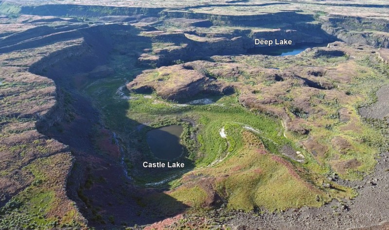
Castle Lake fills a plunge-pool at the base of a 300-ft tall cataract at the opposite (east) end of the Great Cataract Group from Dry Falls, above the east end of Deep Lake. A set of steel ladders put in place during the construction of the Columbia Basin Irrigation Project allow for a safe descent into the basin. In the basin are great views of giant potholes, the flood-sheared face of Castle Rock, as well idyllic Deep Lake. The Castle Lake Basin lies along the east end of the Great Cataract Group. At the base of the cataract is lovely blue-green Castle Lake plunge pool nestled into the rock bench below. Castle Lake lies within a single recessional cataract canyon eroded down to a flood-swept, pothole-studded rock bench that stands 100 feet above Deep Lake. This is the same rock bench of Grande Ronde Basalt where dozens of potholes occur at the opposite (western) end of Deep Lake. Castle Rock itself is an isolated butte along the west side of the Castle Lake basin. It is a faceted butte escarpment nearly sheared off by monstrous flood forces moving across the cataract.
Bretz and His Floods Story – National Geographic
National Geographic has published an outstanding article, “Formed by Megafloods, This Place Fooled Scientists for Decades”, about J Harlan Bretz and his outrageous, fantastical theories of a landscape shaped by huge floods. Most Ice Age Floods aficionados are generally aware of the story, but this one is so detailed and well written it’s worth reading for the story-telling value alone. Please see: This National Geographic site:
Lake Lewis High Water Markers Installed
In April, 2017, Lake Lewis members George Last and Bruce Bjornstad worked with Friends of Badger volunteers Jim Langdon (Trail Master) and David Beach to install Markers showing the Lake Lewis high water marks on Badger and Candy Mountains near Richland, Washington. The Lake Lewis Chapter donated $300 to the Friends of Badger Mountain to purchase the two faux erratics engraved with “Lake Lewis Maximum Elevation 1250 Feet”. One of the markers was installed along the Sagebrush Trail on Badger Mountain, and the other along the Candy Mountain Trail. It was a glorious day!
Getting Our Palouse Falls “WOW” Story Out
A few of us met two years ago in August to decide if we should start our own chapter. We asked the question, “How do we get the word out to see how much interest there is?” We decided the best way to do this was to the attend the upcoming local fairs – Wheatland Communities Fair in Ritzville over Labor Day weekend, the Palouse Empire Fair outside of Colfax the following weekend and the Adams County Fair in Othello the weekend after that. We were fortunate to still be able to get booth space for the first two fairs and to share with the Coulee Corridor (at no cost) for the last one. We quickly rounded up pictures, maps, and books to fill our first booth. We talked to a lot of interested people and signed up new members for our chapter. This year we decided to do the three weeks of fairs again. The Coulee Corridor allowed us to use part of their booth again to help out our fledgling chapter – we will be able to go solo next year. There are a number of good reasons to take the time and expense to do these fairs. We recognize existing chapter members. We advertise our upcoming lectures. We promote our fall bus tour. We sign up new members. We share our flood story. This year we had time to create a more professional booth including local rock samples. This was a good draw for the young visitors as well as the adults. We also had samples of Mount St. Helens ash from the local area and Yakima. It was a great dialog starter – Why are the two samples different? Answer – the local ash is finer and the Yakima ash is coarser because the heavier material dropped out closer to the mountain. We also met with people who were visiting from outside the flood path or had just recently moved in from out of the area. I would ask them if they were familiar with the Missoula floods. Some knew nothing and others just a little. I would tell the story, pointing to the map showing Glacial Lake Missoula and the flood path. The one superlative I would hear over and over again was “WOW”. It reminded me of just how much of a “WOW” area we live in and how easy it is to forget that when you have lived in it all your life. Yes we do live in a “WOW” area and the local fairs have been a great venue to get our “WOW” story out to the public. Lloyd Stoess, President Palouse Falls Chapter, IAFI
Beryllium-10 dating of late Pleistocene megafloods and Cordilleran Ice Sheet retreat
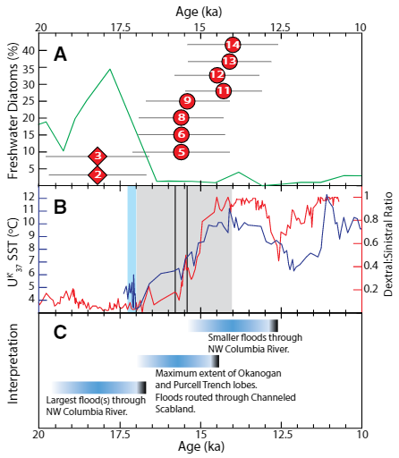
Balbas et. al. use cosmogenic beryllium-10 dating methods to further constrain the timing of ice sheet retreat, as well as the potential pathways for megafloods from both Lake Missoula and Lake Columbia. Read this fascinating Geology article summarizing their findings. Balbas2017 – Missoula Flood Chronology In summary, our new chronological information suggests the following: (1) Blockage of the Clark Fork river by the Purcell Trench lobe by ca. 18.2 ka, resulting in Missoula floods following the Columbia River valley. (2) Blockage of the Columbia River valley by the Okanogan lobe before 15.4 ± 1.4 ka, which shunted Missoula flood water south across the Channeled Scablands. (3) The final Missoula floods at ca. 14.7 ± 1.2 ka, signaling retreat of the Purcell Trench lobe from the Clark Fork valley, yet these floods entered a glacial Lake Columbia still impounded by the Okanogan lobe. (4) Down-Columbia floods at ca. 14 ka from breakouts of glacial Lake Columbia, signaling the retreat and final damming of the Columbia Valley by the Okanogan lobe
German Marshall Fund Fellows Visit Gorge Floods
On May 6th a group of 6 German Marshall Fund (GMF) Fellows from Europe and Russia got a taste of the Ice Age Floods story as they toured the Gorge, shepherded by Krystyna Wolniakowski, the Executive Director of the Columbia River Gorge Commission and a past-fellow herself. This was their last day to do some sightseeing before heading home after three weeks of intensive presentations and meetings with experienced business and political leaders. After being wowed by the scenic beauty and amazing wines of the Gorge they came to Rowena Crest for a brief discussion about the Ice Age Floods at this incredible vantage point. IAFI Gorge Chapter leader, Lloyd DeKay, used maps and illustrations and pointed out several local Floods features to help tell our story of the 1000′ deep floods that roared across the landscape and through Rowena Gap, crashing against and over this promontory on their devastating path to the sea. These Fellows came away awed by the many wonders of the Gorge, and feeling like they had the crowning experience of all the GMF groups touring the States and Europe. The GMF-funded Fellowship Program is a leadership development program intended to help build networks and develop effective transatlantic relationships and engagement for future world leaders. Each year 70+ GMF Fellows are stringently chosen from hundreds of up-and-coming business and political leaders from both sides of the Atlantic. Each small “class” is supported for 6 months of focused distance learning and 24 days of first-hand travel and experiences as they meet and learn from high-level business and political leaders. It was humbling for us to have played a small part in contributing to the experiences of this dynamic group of future world leaders.