Use Social Distancing Time to Explore the Floods with Our Interactive Online Map
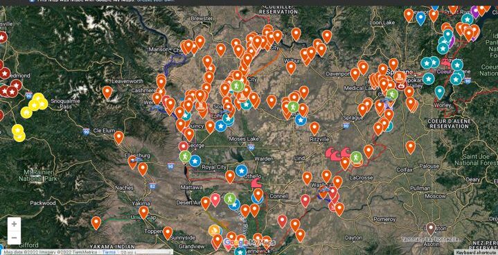
If you’ve ever tried to explore the Ice-Age Floods with a guidebook you’ll know how difficult and frustrating it can be to find and learn about the features in the area you’re visiting. Well, there’s now a solution to that problem; an interactive map that’s available wherever you have internet access. The map features over 300 points of interest throughout our 4-state area, with a description and images that slide out when you click on one of the markers. More features are being added all the time, and we’re planning to expand the map with features related to the Lake Bonneville Flood event that rampaged through the area during the time of the Ice-Age Floods. Since this is an internet-based map, it’s also easy to get driving directions to the site from wherever you are starting from. You can also easily build an informative field trip, exploring and learning about a number of other nearby features with just a few clicks of your mouse. We feel this may be the most useful field guide ever developed to explore ice-age Floods and glacial features throughout our 4-state region. AND it’s absolutely FREE! The only shortcomings we see are 1) the map requires internet access, which isn’t always available in far-flung areas of our region, and 2) we may not have every point-of-interest on the map (YET!). If we’re missing something you think is important we encourage you to submit your suggestion. We also appreciate any comments and/or corrections by email to Webmaster@IAFI.org. We sincerely hope you enjoy using this guide to poke around these fascinating ice-age features.
Explore the Ice Age Floods with 12 New IAFI Brochures

IAFI has compiled 12 brand-new, full-color brochures into a packaged set to help guide you in visiting spectacular ice-age features across all of our 11 Ice Age Floods chapter areas. With these brochures as your guides you can explore the paths of the Ice Age Floods from Montana through Idaho, central Washington and northern Oregon, and even delve into the many glacial features of northwest Washington. Click on any of the brochure covers below to see a full size printable PDF version (note: you’ll need to scale down to print on 8.5×11 letter size paper). Packets of all 12 full-size brochures are NOW available through the IAFI Store and at participating local outlets. Click a cover to open a PDF of any of the brochures below
My Visit to the Othello Sand Crane Festival
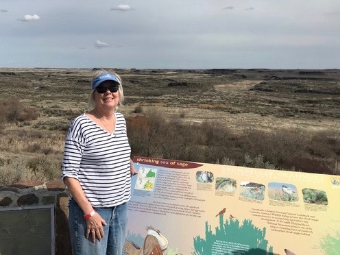
My husband and I attended the 2019 Sandhill Crane Festival in Othello, WA. We went because of my interest in seeing the ice age flood related features, but I also wanted to the the Sandhill Cranes – which we were told accumulate there by the hundreds of thousands. They are large, heron-like birds that like to fuel up in the fields on remnants of corn and alfalfa before heading north for the summer. We were warned to register for events as soon as possible, which we did. Nevertheless, the motels in Othello, a town of 7700, were full, so we stayed in Moses Lake, which is about 15 miles from Othello. The Festival used the high school gymnasium for exhibits and kid’s handicrafts and the classrooms for lectures and presentations. The events are obviously well attended because the parking lots were completely full. My husband was pleasantly surprised to be greeted by the mayor! I enjoyed seeing the familiar faces at the Ice Age Floods Institute exhibit. Our first tour, the evening we arrived, was out to the fields to see the cranes. We had a Fish and Wildlife biologist and an engineer from the Columbia Valley Irrigation Co. Apparently the cranes winter in Central Valley, Calif. and summer in Bristol Bay. They tend to be “right wing” (pun intended). As promised, they were present in the fields in the several thousands. Fortunately, our guides know which fields and sections line roads to take. The cranes make a unique noise, very distinguishable from the honking of geese. There were also hundreds of thousands of snow geese circling like clouds overhead. Unfortunately, the Pothole Lakes were still frozen. The irrigation engineer provided interesting input with regard to the value of the irrigation system, i.e. water provided by the Grand Coulee Dam and a sandy loam soil provided by the ice age floods, The area was obviously rich agriculturally. Our Saturday field trip was with Brent Cunderla, former BLM geologist. He took us through portions of the channeled scab land formations and provided a good overview of the flood story. We listened to his talk prior to the field trip – which provided background on what we were to see. Our Sunday field trip was a hike through the Drumheller channels with Bruce Bjornstad, also a geologist and author of several papers and books on the Ice Age Floods. Drumheller is a state park that includes buttes and cliffs on the columnar basalts. Although I was focused on scab-land geology, the festival had speakers and field trips by many biologists, regional geologists, and and naturalists. If I were to do this again, and I’m tempted, I would attend some of these. All in all, it was a lot of fun. by Lynne Dickman
Ice Age Features in Shallow Waters
Many of the features left behind by the ice age floods are not apparent to the average visitor to areas where the floods were relatively shallow, such as the Bitterroot River valley south of Missoula, Montana. The Bitterroot Valley has erratics and subtle strandlines in several locations. J.T. Pardee, the Montana geologist who in the early 1900’s identified the source of the water for Bretz’s flood, published a paper and sketches specifically about the Bitterroot valley, where he was living at the time. These features can be used to tell the Ice Age Floods story if put together in a useable format. That is just what happened this summer when Jessica Dufresne, a local elementary school librarian, was selected to develop a curriculum aimed at 4th-8th grades under the National Park Service’s Teacher Ranger Teacher program. The program is aimed at linking to lesser known park units such as the Ice Age Floods National Geographic Trail to underserved student populations and offers professionals the opportunity to learn about the resources and educational materials available through the National Park Service. Dufresne, daughter of Glacial Lake Missoula chapter vice president Lynne Dickman, grew up with geology and always found it interesting. Now she can share that enthusiasm with other teachers and young learners. Other partners in the grant were the Montana Natural History Center and the Bitterroot Cultural Heritage trust. The Glacial Lake Missoula chapter also assisted in locating these features and plans to add them to its field trips and its map and guide.
Ice Age Floods Facebook Page
You may want to ‘Like‘ the Ice Age Floods Institute Facebook page to stay abreast of all the News and Shares coming out from the Institute. We’re sharing news and articles well beyond the Floods, including geology, natural history, general articles about the area, videoed talks, events, and any number of articles of general interest. Floods of water, floods of lava, rockin’ rocks, 2-Minute Geology, paleontology, and the mystical birth of the universe all get their 15+ seconds of fame. We’ll keep our eyes open to find and share items of interest to you, and of course you can share with us too.
Missoula Flood Rhythmites
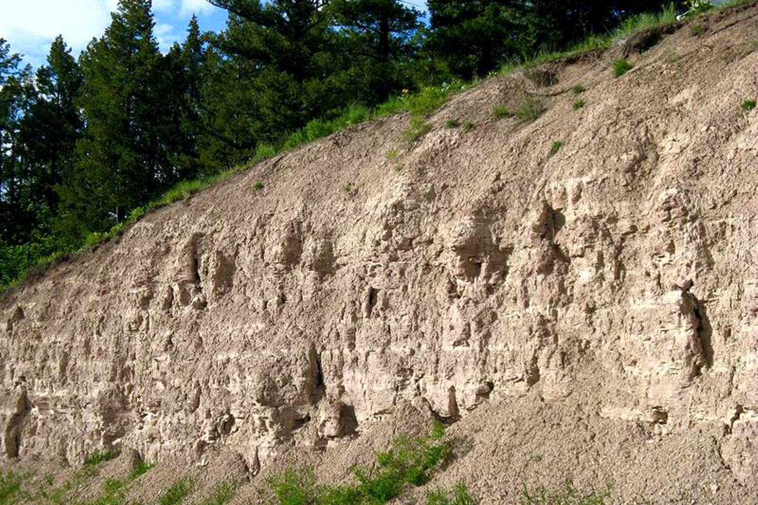
Lake Missoula filled many times and emptied catastrophically in many Missoula Floods. Rhythmite sequences [a series of repeated beds of similar origin] at numerous localities provide this evidence: slack-water rhythmites in backflooded tributary valleys below the dam indicate multiple floods, and varved rhythmites in Lake Missoula attest to multiple fillings of the lake. Below the dam, most slack-water rhythmites are graded beds deposited by flood bores surging up tributary streams. They grade upward from coarse sand and gravel to silt, with occasional ice-rafted erratics. The tops of some rhythmites are marked by thin paleosols, or buried soil horizons, which indicate a period of subaerial exposure. Thus, each rhythmite represents a separate flood event, and each deposit records multiple floods. The most complete record occurs at Sanpoil Valley, an embayment on the north side of Lake Columbia, where varved rhythmites document 89 flood events, with the period of time between floods initially increasing to a maximum of about 50 years and then decreasing to less than 10 years. Thousands of varves were deposited in Lake Missoula. At the best-known Ninemile locality near Missoula, about 40 rhythmites consist of varves overlain by a sand/silt layer. The varves were deposited on the floor of Lake Missoula, and the sand/silt layers represent subaerial exposure and deposition in a stream. The number of varves in each rhythmite varies from 9 to 40, decreasing regularly upward, and the total number of varves is just less than one thousand. An interpretation of these data would suggest: [1] Lake Missoula filled and emptied [in a catastrophic flood] about 40 times, [2] it took 9 to 40 years to fill the lake, each successive lake requiring less time, and [3] the process was repeated over a period of about one thousand years. Because Ninemile is about in the middle of the very long lake, the record here would not provide a complete history of the lake. Correlating Ninemile with the downstream record would suggest these events were in the latter half of the entire flood history.
Glacial Lake Missoula
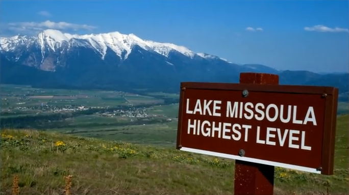
This feature-filled video by Tom Foster and Nick Zentner explores the evidence for Glacial Lake Missoula, and provides a treasure trove of places to visit and sights to see when you plan your field trip to the area.