Julie Bishop – Coeur du Deluge Volunteer
Julie Bishop is a founding member of the Coeur du Deluge Chapter of the ice Age Floods Institute and the only continuous member of the Chapter. She has served as Treasurer of our chapter for at least 15 years. Her service to the Coeur Du Deluge Chapter goes way beyond taking care of our financial needs. Julie was and is always there supporting our chapter’s activities (public lectures, field trips and the distribution of IAF-related educational material). She did and does this cheerfully and efficiently. She somehow finds time for our chapter even though she has a full-time job with the Idaho Department of Highways. She has another full-time job at home taking care of the family farm, especially their horses. Julie casually brushes off her contributions to IAFI and Coeur du Deluge, saying that although she did some of the “legwork to start the chapter” the ultimate responsibility for the creation of our chapter was based on the long time flood interest of her friends and co-founders of the CDD Chapter: Kermit Kiebert, Jon Burkhart and Mark Heisel. She continually underplays her contributions. But that is the grace and charm of our Julie Bishop. Thanks for you unstinting service Julie, it’s truly appreciated!
Volunteers Help Shape the IAFI!

We’re reaching out to ask for your help. As we work toward our mission of promoting public awareness and education about the Ice Age Floods, our chapters have been facing a significant challenge: a shortage of active member volunteers willing to step into leadership roles or assist with essential chapter functions. Many of our current leaders are in their 70s and 80s, and the demands of their roles are becoming challenging. While our dedicated leaders works to maintain our organization’s momentum, we need support to ensure our continued growth and success. Your involvement will be crucial in helping to: Organize events: Assist with planning field trips, chapter functions, and speaker series. Provide administrative support: Help with recordkeeping, website updates, and newsletter contributions. Engage with the community: Connect with local schools and media outlets to spread awareness about our mission. Contribute fresh perspectives: Share your ideas and expertise to help us adapt to a changing world. Here are some ways you can get involved: Volunteer for events: Help plan and execute field trips, workshops, and conferences. Join a committee: Contribute to our leadership team and help make important decisions. Share your expertise: Offer your skills in areas like marketing, communications, or technology. By becoming more involved, you can: Strengthen your chapter: Contribute your time and skills to make your local chapter more vibrant and effective. Share your knowledge: Bring new ideas and contemporary skills to our organization. Support the organization: Help IAFI achieve its goals and become the foremost provider of Ice Age Floods information. No matter your level of experience or commitment, we welcome your participation. Whether you can volunteer a few hours a month or are interested in taking on a leadership role, your involvement will make a significant difference. The involvement of many will lighten the load on the few, and also bring a much-needed infusion of energy and fresh perspectives. We believe that by working together, we can strengthen our organization and better serve our mission of promoting public awareness and education about the Ice Age Floods. Your participation is essential. To get involved, please contact your local chapter through the IAFI.org website
Unearthing the Secrets of Spokane Valley: A Recap of the IAFI June Jamboree
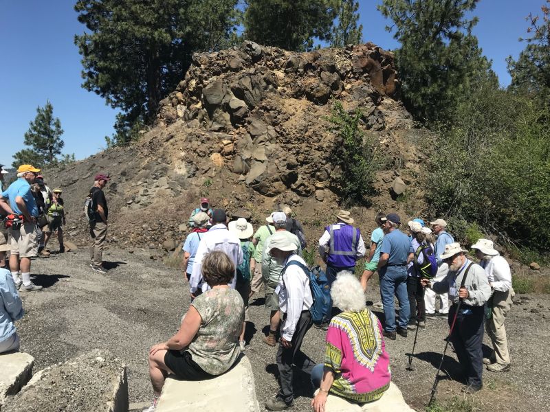
This year’s IAFI June Jamboree delved into the fascinating geological history of Spokane Valley, contrasting it with the iconic Grand Coulee and Dry Falls, explored during last year’s Jubilee. Challenging the Landscape: Unlike the open spaces of Dry Falls, Spokane Valley presented a unique challenge – showcasing evidence of Ice Age Floods within an urban environment. Our chapter tackled this brilliantly, organizing hikes and car caravans departing from convenient public parks and commercial areas. Evening Explorations: The program’s highlights included captivating lectures. Professor Emeritus Dean Kiefer shed light on J Harlen Bretz’s Spokane associates, while renowned naturalist Jack Nesbit brought the story of the first Columbian Mammoth discovered near Latah Creek in the 1800s to life. Celebrating Success: The Jamboree culminated in a relaxed gathering at Mirabeau Meadows. Registrants, leaders, and participants exchanged insights and experiences, with a resounding appreciation for the chapter’s efforts. Comparisons were drawn, highlighting how our Spokane Valley exploration continued the excellence of the Puget Lobe’s outing at Dry Falls last year. A Delicious Finale: The grand finale was a catered Longhorn Barbecue overflowing with delicious food. Everyone left satisfied, with many even taking home doggie bags to savor the flavors afterward. Check out more images from the event in this Google Photo Album. Meet the Masterminds: Linda & Mike McCollum: This dynamic professor emerita and a research geologist duo co-led tours and car caravans, sharing their latest research on the Spokane area’s Ice Age Floods, and shaping the Jamboree’s theme. Michael Hamilton: A gifted geologist, Michael led hikes and the bus trip, encouraging questions and offering honest answers. Don Chadbourne & Chris Sheeran: Don, the chapter treasurer, managed logistics with expertise, while Chris, our media and registration guru, ensured a smooth experience. Melanie Bell Gibbs: A past president and national board member, Melanie oversaw participant check-in and badge distribution. Dick Jensen: Dick handled bus transportation and provided crucial support throughout the Jamboree. Jim Fox: The chapter vice president secured speakers and offered his assistance wherever needed. We also owe a great deal to the participant volunteers who proved invaluable in assisting us in all our efforts. Through the combined efforts of many the IAFI June Jamboree was a resounding success, fostering exploration, education, and a deeper appreciation for the Spokane Valley’s unique geological heritage. Being present with so much information and conversation among such extensive expertise was to witness the scientific process in action. Meeting people from other chapters was particularly nice, putting faces with names we know. We all learned a lot.
Scabland – The Movie, A Google Earth Odyssey

“Scabland” – the Movie, A Google Earth Odyssey “Scabland” is a media complement to CWU Professor Nick Zentner’s 2023-2024 A-Z YouTube geology series that re-treads the ice age floods and the work of Professor J Harlen Bretz and others. In this short animation, viewers virtually fly to a selection of locations visited by geologist Dr J Harlen Bretz, with quotes from his original field notes, geolocated in Google Earth and animated with Google Earth Studio. To see more of these locations, visit https://www.geology.cwu.edu/facstaff/nick/gBRETZ/ This video was done as an experiment/prototype by the authors, Glenn Cruickshank and Eric Larson, to showcase Google Earth, virtual special effects techniques, some of the spectacular landforms caused by the floods, the impacts of ice and water during the Last Glacial Maximum and the field locations of J Harlen Bretz. Eric Larson in Billings MT runs Shashin Studio, a VFX video production company (contact@shashin.studio). Google Earth Glenn is a retired photojournalist and consultant in Liberty Lake WA. Credits: Glenn Cruickshank Eric Larson Two Steps From Hell Made with Google Earth and Google Earth Studio. Thanks to The Families of J Harlen Bretz and Thomas Large, Nick Zentner, Glenn Cruickshank, Bruce Bjornstad, The Ice Age Floods Institute, and many others.
Must See Floods Features in Northern Idaho

SOME LOCAL NORTHERN IDAHO ICE AGE FLOODS and GLACIAL FEATURES Purcell Trench – This structurally formed valley became the passageway for the Purcell Ice Lobe that divided into five glacial sub-lobes. The east moving sub-lobe blocked the Clark Fork River forming Glacial Lake Missoula, the source of the Ice Age Flood waters. Other sub-lobes modified and deepened the basin now occupied by Lake Pend Oreille or helped define several important N-S transportation routes. The Purcell Trench is visible from City Beach in Sandpoint and Schweitzer Mountain Rd. Hwy 95 follows the Purcell Trench from Sandpoint to beyond Bonners Ferry. Cabinet Gorge – Contact of Pleistocene Ice and Glacial Lake Missoula Water – Although the contact of the Pleistocene Ice and the lapping waters of Glacial Lake Missoula was in flux as the glacier advanced and retreated, the Cabinet Gorge is considered by many to be a likely location of the terminus of the Clark Fork sub-lobe that blocked the drainage of the Clark Fork River. Evidence of glacial erosion and till deposits indicate glaciation; however, flood deposits on the south side of the river attest to Ice Age flooding. Cores taken during the construction of the Cabinet Gorge Dam suggest multiple stages and events of ice damming. An AVISTA maintained viewpoint at the Cabinet Gorge Dam with Ice Age Floods signage provides an excellent location to ponder the formation and disintegration of the ice plug blocking the Clark Fork River. Glacial Striations – Striations can be viewed along Hwy 200 east of Hope and on the south side of Castle Rock east of Clark Fork. Glacial/Flood Related Erratics – Large and small erratics cover the glacial and flood modified landscape. Large erratics can be seen along Hwy 200 east of Clark Fork, in Sandpoint’s City Beach and in Farragut State Park. A large pile of erratics excavated from flood deposits are visible on the west-side of Hwy 95 south of the Hoodoo Channel. A giant ice-rafted flood related erratic weighing over 1,600 tons is located on the east-side of Hwy 41 near Twin Lakes. Lake Pend Oreille – Cross-section morphology, depth, and sediments – This is where it all started! Lake Pend Oreille is the largest lake in Idaho and the deepest lake in the Pacific Northwest and the 5th deepest in the US. The lake level is 2062 ft above sea level with depths over 1,000 feet and an additional layer of over 1,500 feet of glacial-fluvial deposits going to bedrock, with the surrounding terrain as high as 6002 ft. The glacially modified U-shaped bedrock valley, cut to approximately 600 feet below sea level, was formed by the Pend Oreille glacial sub-lobe. This glacial sub-lobe was up to 4,000+ ft. thick and 30+ miles wide. It was the ice plug responsible for blocking the Clark Fork River. It collapsed catastrophically as often as about every 10-60 years, releasing 40-100 Ice Age Floods. The location of the lake is probably related to an old river valley controlled by faults. The Lake Pend Oreille basin was carved by the repeated advances of Pleistocene ice and scoured by ice age floods. With the waning of ice age flood waters, the basin was, and continues to be, filled with glacial outwash and flood deposits. The lake is dammed at the south end by thick glacial and flood deposits the mark the beginning of the “Outburst Deposits”. There is a pullout on Hwy 200 approximately one mile west of Hope with signage already established that provides a great view looking south across Lake Pend Oreille to the Green Monarch Mts. Another view of the former ice plug location along Hwy 200 is the mouth of the Clark Fork River at the Clark Fork Drift Yard. Giant Current Dunes or MegaRipple Marks – One of Bretz’ most important pieces of evidence for catastrophic flooding was the “giant current dunes.” These large-scale bedforms appeared as patterns of parallel ridges and swales on many aerial photographs in the flood channels in the scabland of Washington, but had escaped recognition from the ground because of their size. Giant Current Dunes are visible west of Clark Fork near Castle Rock; however, the most prominent and visible Giant Current Dunes are located several miles east of Spirit Lake along Hwy 54 where the highway cuts through the dunes showing their undulating profile. The location of many of the telephone poles on the crest of these dunes accentuates these landforms. The dunes form transverse to the current direction, and form cusps that are convex upstream, with arms that point downstream. Furthermore, the size of the cusps appears to decrease in the direction of lower velocity. Internally, the dunes consist of gravel and pebble foresets. Giant current dunes exhibit an asymmetrical profile with the downstream (lee) slope steeper than the upstream slope. Crests range from 20 to 200m apart and heights range from 1 to 15m (Baker and Nummedal, 1978) and are among the largest measured throughout the Floods area. The Spirit Lake current dunes can also be easily recognized from the air by their characteristic pattern, accentuated by vegetation. This dune field is immediately in the path of the breakout from Lake Pend Oreille, and experienced some of the highest energy flows. Rhythmites – Rhythmites are glaciolacustrine sediments associated with flood events and are useful in attempting to determine the number of Ice Age Floods. A 112-foot cross-section of rhythmites is located at the junction of East Fork Creek and Lightning Creek approximately 6.5 miles northeast of Clark Fork along Lightning Creek Road (NF-419). Proglacial Deposits – This type of deposit is found associated with most of the drainages on the south side of the Clark Fork Valley and extend from the mouth of the Clark Fork River to nearly Thompson Falls in Montana. These sediments are glacio-fluvial deposits deposited in contact with the ice and therefore provide evidence of glaciation in the Clark Fork River drainage. The associated geomorphic features formed by these deposits are referred to as “kame deltas”. The gravel pit associated with Dry Creek (approximately 8 miles west of Clark Fork
Scholars Trek on the Ice Age Floods Trail

Ice Age Floods Fourth Grade Curriculum Development One of the missions of the Ice Age Floods Institute is to educate young people about the Floods and the influence of the Floods on their lives today. The IAFI Educational Outreach Committee has contracted with the curriculum design firm The Inspired Classroom to produce engaging lesson materials to excite fourth-grade students from across the Northwest about the Ice Age Floods. The curriculum will contain video footage narrated by experts and lesson plans for use by fourth grade teachers in Montana, Idaho, Washington and Oregon. The story, entitled “Scholars Trek on the Ice Age Floods Trail,” will begin with a flyover video of the trail, including Glacial Lake Missoula, the Clark Fork Ice Dam, the Rathdrum Prairie, Spokane Falls, the Channeled Scabland, Lake Lewis, the Columbia River Gorge, Lake Allison, and the deposition of the eroded sediment on the continental shelf at the mouth of the Columbia River. Along the route, students will be introduced to the ways in which the Floods influence society today, including the influence of the Floods on the Spokane Aquifer and on railroad and highway routes across the Pacific Northwest. Funding for the project will come from grants, the IAFI, and from private benefactors. The continued support of IAFI members through membership dues and donations helps fund projects like this. The Education Committee is made up from a sampling of IAFI Board Members and Chapter Presidents from each state: Jim Shelden (Glacial Lake Missoula); Tony Lewis (Coeur du Deluge); Melanie Bell and Consuelo Larrabee (Cheney-Spokane); Gary Kleinknect (Lake Lewis) and Dale Lehman (Puget Lobe.) In the future, the Education Committee plans to work on curriculum materials for middle and high school students. By Dale Lehman, 04/14/2022
Ice Age Floods for Southside Elementary 4th Graders

For Coeur du Deluge Chapter President Tony Lewis, an opportunity to lead a Sandpoint 4th grade class in a learning unit on “how Idaho landforms were created” came up suddenly on Oct. 8th. Terese Luikens, the 4th Grade Teacher at Southside Elementary School had 19 students wanting “an actual field trip where you can show and tell us about how glaciers formed some of our lakes.” 3 days later Tony was in front of Mrs. Luikens’ 19 excited and exuberant students, struck by how 4th graders react to rocks and a guest presenter. Hands were up, even before his “Landforms of North Idaho: How They Were Formed and What Caused Them” presentation started. How can you NOT be swept up in their enthusiasm and amazed by their unending questions, some of which are actually related to the topic? They were more excited when he left their school than when he had arrived, and the field trip was happening two days later! Unfortunately, the weather didn’t cooperate. It was cold and windy with a chance of rain when they met at the Pavilion at City Beach in Sandpoint, ID at 10 AM. Were these 4th graders put-off by a “little” inclement weather? Of course not, but they did seem disappointed when told that they were not allowed to go swimming. Hands up again, asking questions, wanting to show where they lived, where we were and where we were going on the maps and images Tony had. After an hour reviewing what was talked about on Monday, with more information about David Thompson, the Ice Age Floods, glaciation and the Purcell Trench and how different lakes (Round, Cocolalla, Mirror and Pend Oreille) were formed, we all loaded up for a drive through the bottom of the Purcell Trench, the Pack River Delta and finally to the Geologic Overlook just one mile east of Hope, ID. Before leaving the bus, the students were given their boundaries and they abided. Although the clouds covered some of the scenes, we could see the steep-faced Green Monarch Mts. where the Purcell Trench Lobe glacier divided into four sub-lobes. One of the sub-lobes went up the Clark Fork River, plugging up the drainage basin and causing Glacial Lake Missoula. Another lobe moved southward, deepening the basin now occupied by Lake Pend Oreille. The students seemed to enjoy viewing the wide-expansive scene of ‘the place where the Ice Age Floods started’. The field trip ended when it started to rain, and the drive back to Sandpoint was uneventful, although I was admonished, in a nice but serious way, for walking up and down the aisle because it was dangerous and “I might break my back!” I agreed and took my seat. It was a fun learning experience for me, and I hope it was for them also.
Nick Zentner – More Geology Videos

Are you looking for new geology videos? Nick Zentner has done a long series live geology lectures from his home in Ellensburg and posted them online to his YouTube channel https://www.youtube.com/user/GeologyNick/videos He is now recording a series of “Nick on the Fly” virtual field trips and posting them on the same YouTube channel https://www.youtube.com/user/GeologyNick/videos Join Nick as he explores the geology of the Pacific NW and many other topics.
Use Social Distancing Time to Explore the Floods with Our Interactive Online Map
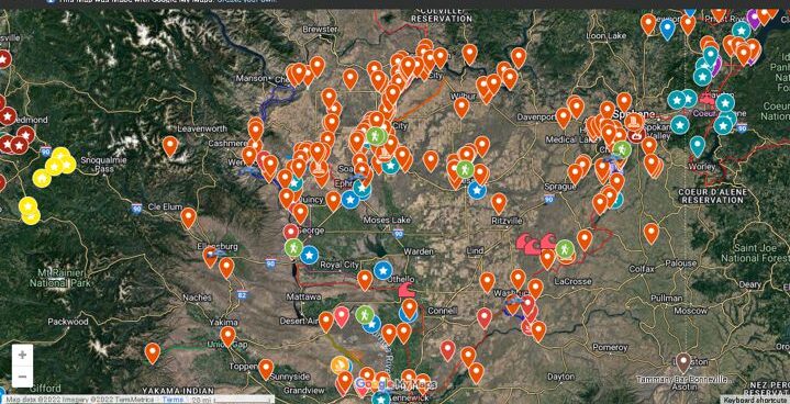
If you’ve ever tried to explore the Ice-Age Floods with a guidebook you’ll know how difficult and frustrating it can be to find and learn about the features in the area you’re visiting. Well, there’s now a solution to that problem; an interactive map that’s available wherever you have internet access. The map features over 300 points of interest throughout our 4-state area, with a description and images that slide out when you click on one of the markers. More features are being added all the time, and we’re planning to expand the map with features related to the Lake Bonneville Flood event that rampaged through the area during the time of the Ice-Age Floods. Since this is an internet-based map, it’s also easy to get driving directions to the site from wherever you are starting from. You can also easily build an informative field trip, exploring and learning about a number of other nearby features with just a few clicks of your mouse. We feel this may be the most useful field guide ever developed to explore ice-age Floods and glacial features throughout our 4-state region. AND it’s absolutely FREE! The only shortcomings we see are 1) the map requires internet access, which isn’t always available in far-flung areas of our region, and 2) we may not have every point-of-interest on the map (YET!). If we’re missing something you think is important we encourage you to submit your suggestion. We also appreciate any comments and/or corrections by email to Webmaster@IAFI.org. We sincerely hope you enjoy using this guide to poke around these fascinating ice-age features.
New Release – Glacial Geology Maps of North Idaho

IAFI Store is proud to offer a new, two-sided Glacial Geology of North Idaho map that includes a GLACIAL GEOLOGIC MAP OF NORTH IDAHO on one side and a SHADED RELIEF MAP OF NORTHERN IDAHO AND PARTS OF WESTERN MONTANA AND EASTERN WASHINGTON on the other side.The maps are 33.75” x 21.5” in size and are available as both flat and folded versions at a price of $9.95 + tax and shipping. The GLACIAL GEOLOGIC MAP OF NORTH IDAHO is a color map produced at the scale of approximately 1/175,000 that represents over 30 years of research and field work by Dr. Roy Breckenridge, former Idaho State Geologist and VP of the IAFI Coeur du Deluge Chapter. The second author of this map was Dean Garwood who, following Roy’s passing, organized Roy’s information and used his GIS skills to put together multiple information layers to produce the final map. The map is in commemoration of Roy and his dedication to the fields of geology and education and his commitment to our chapter and the Ice Age Floods Institute. The SHADED RELIEF MAP OF NORTHERN IDAHO AND PARTS OF WESTERN MONTANA AND EASTERN WASHINGTON is a shaded, colorized relief map generated by Dean Garwood, overlain with other important geographic information to make the map more useful. The shaded relief map was printed at a scale of approximately 1/198,000 and covers a larger area of the Inland Northwest. The Coeur du Deluge Chapter, a member of the non-profit Ice Age Floods Institute (IAFI), is a committed advocate, educator and marketer of the Ice Age Floods experience as a significant international natural and cultural heritage phenomenon. The production and distribution of this two-sided map is done in accordance with our Mission as an educational non-profit, more concerned with the map’s distribution than profits, which is the reason the map is priced less than $10. We plan to provide a set of maps free of charge to any local school and any local library in North Idaho, and to sell the maps through various outlets, primarily in Sandpoint and in Coeur d’Alene and Spokane, as well as through the Ice Age Floods Institute Store and Keokee Publishing.