Test Elementor Post
Add Your Heading Text Here [auto-iframe link=”https://docs.google.com/document/d/e/2PACX-1vSFsSoQRGsaPifqMIFC9LgIY7lTKGeNHF0vzFnAryTvvsC9LPV7NX-BrJ5VjkuKXamUrhavtG2igR_l/pub” width=400 height=1000 autosize=yes] style=”height:1000px !important;”
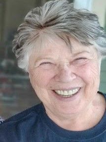
Linda McCollum

Cheney-Spokane Chapter President We welcome Linda McCollum as the new president of the Cheney-Spokane Chapter. Linda is a professor emeritus with the Department of Geology at Eastern Washington University. Education & Employment: Linda completed her BS and MS at University of California at Davis in the early 1970’s, and then worked for a year as an assistant geophysicist for the California Geological Survey in Sacramento. In 1980, she received her PhD from the State University of New York at Binghamton, and spent the 1979-1980 academic year teaching at Sul Ross State University in west Texas. For the next three years, she headed up the Cordilleran Geological Survey in Reno, Nevada, which was an affiliate of Gulf Oil and Exploration Company, Houston, Texas. She joined the geology faculty at EWU in September 1983, taking the position of petroleum geologist. She taught upper division and graduate courses, including petroleum geology, micropaleontology, paleoecology, clay mineralogy, and spring field camp, in addition to supervising Masters theses. In 1987, Ernie Gilmour went into the university administration for several years, so she took over his courses in invertebrate paleontology and historical geology, and later, when John Buchanan became heavily involved in the graduate program, she took over the stratigraphy course for several years. When Bill Steele retired, she took over his environmental geology course. Thus, she ended up almost exclusively with required undergraduate courses by the time she became departmental chair in September 1993, serving two 4 year terms. After the graduate program was terminated due to university budget cuts, Linda developed an integrative studies course on the history of mining in the Pacific Northwest, and an international studies course on world resources and population. She also taught the Earth Science education methods course. During a couple of summers in the mid-1990’s, she teamed up with then-Provost Jim Hoffman to teach a field course on dinosaurs, in which they participated in digs on the Colorado Plateau and along the Rocky Mountain front in Montana. This course was aimed primarily at the K-12 teachers. She had to cut back a little on course offerings during her years as departmental chair from 1993-2001. She taught 23 different courses during her 25-year tenure, which reflects the ever-changing nature of the geology profession, coupled with the program demands and faculty availability. Research: Her research interests were initially in early Paleozoic ecology and faunas, stratigraphy, and tectonics. She published peer-reviewed papers on Devonian biostratigraphy and paleoecology in New York State; Cambrian lithostratigraphy, describing ten new geologic formations in Utah and Nevada; and has described early Middle Cambrian trilobite faunas from Nevada, California, and South China. She has authored or coauthored over a dozen peer-reviewed scientific papers and presented over three dozen abstracts and talks or poster sessions. In the last decade, her focus has been on the Ice Age floods, particularly within the confines of glacial Lake Columbia. During the last few years, she and her husband Mike have completed geologic mapping of ten 7.5-minute quadrangles, which cover about 500 square miles, westward from Cheney to Edwall and northward to Wellpinit on the Spokane Tribal Reservation. She has located water wells in these quads and matched them up with existing DOE water well reports, in order to characterize the groundwater aquifer system underlying the West Plains. As a member of the Water Resources Inventory Area (WRIA) 54, administered by Spokane County Water Resources Division, she published a report on the West Plains aquifer system. Grants: Linda’s research was funded by EWU and National Science Foundation grants and contract through WRIA 54 totaling over half a million dollars. In recognition of her academic expertise, she was elected to represent the United States by the International Subcommission on Cambrian Stratigraphy. Retirement & beyond: Linda became a founding member of the Cheney Spokane Chapter in 2004 and joined the board of directors in 2017. She was elected President in December, 2023. Other interests: She had taught at the equestrian center at UC Davis during her student years, and for recreation, she still enjoys horseback riding. She also does quite a bit of hiking. Lately she has gotten the most enjoyment out of gardening and playing around with her cats. Updated December 15, 2023
Journey Through Time: Explore Drumheller Channels

Nestled in the heart of Washington state, the Drumheller Channels offer a unique glimpse into earth’s history, carved by the immense power of Ice Age Floods. This National Natural Landmark is a must-visit for anyone seeking breathtaking landscapes, remarkable geological formations, and a chance to understand the power of nature. Witness the Scars of Ancient Floods: Drumheller Channels are a remarkable example of the Channeled Scablands, a vast landscape sculpted by cataclysmic floods that roared across the region millennia ago. Hike or bike through dry riverbeds, past towering basalt cliffs, and over rolling hills, all remnants of these powerful events. Imagining the colossal force of water that once flowed through these channels is an awe-inspiring experience. Explore Diverse Landscapes: The Channels offer a variety of landscapes, each offering its own unique charm. Hike along the McManamon Trail for panoramic vistas of the Scablands, or venture into the Crab Creek Unit to discover hidden waterfalls and basalt columns. For a unique perspective, climb to the top of “Nick’s Columns” and marvel at the vastness of the Channeled Scablands. A Haven for Wildlife: The diverse ecosystem within the Drumheller Channels provides a sanctuary for various wildlife species. Birdwatchers can spot over 23 species of ducks and geese, while sharp-eyed visitors may catch a glimpse of deer, coyotes, and even bald eagles. The Channels are also a vital nesting ground for many birds, making it a crucial habitat for preserving regional biodiversity. Connect with the Past: Explore the fascinating human history of the Drumheller Channels. The region has been inhabited for thousands of years, with evidence of Native American presence found throughout the area. Learn about the early settlers who braved the rugged landscape and contributed to the development of the region. A Place for Recreation and Reflection: Whether you’re an avid hiker, a passionate photographer, or simply seeking a peaceful escape, Drumheller Channels has something for everyone. Hike through scenic trails, enjoy a picnic amidst the breathtaking scenery, or simply relax and soak in the tranquility of nature. Plan Your Visit: The Drumheller Channels are open year-round and offer free access. Several trailheads provide easy access to various sections of the Channels. The Ice Age Floods Institute offers valuable resources, including maps, trail descriptions, and educational information. Be sure to pack sturdy shoes, appropriate clothing for the weather, and plenty of water for your adventure. Come experience the grandeur and wonder of the Drumheller Channels. Witness the power of nature etched into the landscape, explore the diverse ecosystem, and connect with the rich history of this remarkable place. It’s a journey through time that will leave you with a lasting sense of awe and appreciation for the natural world.
Lyle Cherry Orchard Interpretive Panels Installed
Last week, Friends of the Columbia Gorge completed installation on their first-ever interpretive trail signs at the Lyle Cherry Orchard Preserve! They’ll be sharing MUCH more on this story in spring 2024 (including guided outings!), but if you’re intrepid enough to hike this trail during the winter, check out the brand new signage with QR-code links to learn more about the preserve and the Gorge. Stay tuned for more in the coming months. And check out the Ice Age Floods geology recording.
Don Chadbourne

IAFI Board Member I have degrees in geology from the University of Wisconsin and civil engineering from the University of Wyoming. I worked as a well site geologist on oil drilling rigs throughout the Rocky Mountain region and then as a civil engineer for the Washington State DOT. The last job brought me to Spokane. My first IAFI Field Trip was in 2010 with Gene Kiver and Bruce Bjornstad on the Cheney-Palouse scabland. Subsequent field trips and hikes throughout the region, with Mike and Linda McCollum, Michael Hamilton and others, taught me a lot about the geology of the area and the Ice Age Floods. I have been a board member with the Cheney-Spokane Chapter since 2019 and am now the Chapter treasurer. I lead hikes on some of the local trails, describing the geologic features and sharing the flood story.
Wenatchee Valley Erratics Leadership Changes Are Coming
Major changes are looming for the Wenatchee Valley Erratics Chapter. The chapter president (Brent Cunderla), treasurer (Dan Smith) and publicity person (Susan Freiberg) are all planning to step down in June, 2024. These critical positions don’t involve a lot of time or work, but they are essential.to the health of the chapter. All three are willing to help guide replacements, so if you are interested to learn more about the positions please email the chapter at Wenatchee@iafi.org.
An Old Timer (Jeff Silkwood) IAFI Story

In the early days, the IAFI and National Geologic Trail were mainly good intentions and lacking in ways to communicate how enormous and special this landscape was. Jim Shelden, then Regional Geologist for Region One of the US Forest Service in Montana and now president of the Missoula chapter of IAFI, realized a good map was necessary to galvanize action on the project and legitimize the new group Jim Shelden had just hired Jeff Silkwood in an open-ended position as a Stay in School Cartographer and Database person in 1995. Jeff had just returned from military service and was enrolled in classes at U Montana. Jeff was assigned to digitizing maps of the Beartooth Mountains and other mapping projects in the states of the Northern Rockies. But he was particularly interested in Glacial Lake Missoula and the Ice Age Floods. And he knew he had the computer skills to use existing data to put a map together. As the maps grew larger, more complex and included features like hill shaded relief and multi 1-degree by 1-degree tiles fitted together that no one else could do, it slowly dawned on Jim that this guy was really something. The only limitations were equipment – no Dept of Ag computer could handle it nor could any plotter manage the print task. In those early days this involved overcoming computer limitations on the size of files. Combining digital elevation models for multiple tiles and maps resulted in gigantic files for the times and processor’s abilities. Jeff wrote 2500 lines of code linking multiple computers, writing new code to handle the plotter problems to complete this project over about a two year time span, working on this while completing other jobs which had more firm deadlines. The basic data came from the USGS digital version of topographic maps supplemented with data from NASA satellite images. Google was working with some of the same data for use in its own maps, and there was some back and forth communication with them on how to solve similar mapping problems. Mapping issues that came up for this project included drawing a boundary for the west coast at a time when the ocean level was much lower – which had to be done by hand. And decisions about the extent of the lake and the extent of the continental ice sheet and glaciers – maximum levels and multiple contributors as to extent were used. Initial drafts were printed on a pen plotter, then the imagery was upgraded to an ink jet printer, which was subject to fading. The final map with photo images was turned into print plates by the Forest Service special Publications group in Washington. Approval for even printing the map was complicated. – it was (and still is) the only map ever printed by USFS which was more than a travel map and identified by author. An initial printing of 2000 copies was authorized – and sold out in 3 days. Another printing of 2500 was done. The USGS ordered a third printing they sold from their Denver and Spokane Libraries. It is no longer available, supplanted by on-line maps, and subsequent versions with different detail (such as highways) done by Eastern Washington University and others. A few copies of the original map still exist, and Jeff is still working on cartography for a private firm in Missoula. The importance of the original map to give IAFI credibility and as a tool to tell the story and sell the need for a special designation has never been officially recognized…until now. Thank you Jeff for your personal commitment to this project, and thank you Jim for your support in making it happen.
IAFI Store Prices Increase for Non-Members in January

Non-members of IAFI have been increasingly taking advantage of our trust-based Free Shipping for Members. So we’ll be increasing the IAFI Store prices by 10% for non-members beginning in January 2024, but Members will continue to get Free Shipping and a 10% discount off their Cart total. Rather than impose a Member Login requirement we’ll be sending out a coupon code that members can use for their 10% Off and Free Shipping. We’ll see how this works out and make adjustments as needed to keep Store prices low for our Members.
CONSUELO LARRABEE – April 14, 1939 – June 21, 2023
Consuelo Larrabee, a beloved member of the Ice Age Floods Institute Board of Directors and the Cheney-Spokane Chapter Board passed away suddenly on June 21, 2023; she was 84 years of age. Consuelo’s life could be described as one who advocated passionately for animal rights, human rights and the arts. She worked closely with children for most of her life, inspiring the love of learning, the outdoors, music, and animals, to mention only a few. She very much enjoyed traveling the world, often with friends or to see friends, and her trips always included hiking, the arts, meeting people, and enjoying great food with friends. She very often credited her mother and grandmother who provided her with a safe, playful, creative, inspirational and literate childhood. Consuelo’s grandfather, Charles X Larrabee, was instrumental in 1915 with creating Larrabee State Park, established as the first state park in Washington. He and his wife Francis donated an extensive piece of land along Chuckanut Bay to create the park and continued to donate large parcels of land over the years to expand the park. Larrabee State Park was one of Consuelo’s favorite places to spend time throughout her life, hiking through the beautiful forests, and enjoying the rocky beach. Consuelo contributed to and changed the lives of so many humans and animals, making their worlds a more special place. She loved those around her deeply, always celebrating a birthday, wedding anniversary or important event and made sure all knew they held a special place in her heart. Consuelo was a member of the Ice Age Floods Institute Board of Directors for almost 20 years and also served on the Board of Directors for the Cheney-Spokane Chapter for the last seven years. Her involvement with the Ice Age Floods story was one of the great loves in her life. She carried brochures in her handbag and in her car, distributing them to individuals she met every place she travelled. She made sure they knew of how the Great Missoula Floods created the landscape we enjoy in the Northwest today. Along with several others involved with the Institute and the Cheney-Spokane Chapter, she worked diligently with this team over a couple of years writing Floods interpretive signs. These signs are located in the Ice Age Floods Playground at Riverfront Park located on the east bank of the Spokane River in downtown Spokane. These signs provide visitors of all ages the opportunity to learn about all that shaped our regions topography. Consuelo was born on April 14th, 1939,; to Edward Payne and Consuelo McMillan Larrabee in Spokane, Washington. She attended school at St. Paul’s School for girls in Walla Walla, Washington. She then received her Bachelor of Fine Arts degree from San Francisco Art Institute, as well as a Masters in Special Education from Teacher’s College at Columbia University. Following her father who had spent seven years studying at Oxford University, she too attended Oxford University, taking teaching courses…and playing softball! Consuelo served as a head teacher in a program for Chinese immigrant children in San Francisco. This was followed by being a classroom teacher for deaf children, some with multiple disabilities, in New York City, San Francisco and Spokane. In 1989, Consuelo moved to San Juan Island for sixteen years. She served as Head of the Program Committee for the local theatre, as well as being active in building an animal shelter and promoting awareness about Orca whale population. Consuelo lived in Seattle for nine years, where she dedicated her life to the Seattle Opera, (being chauffer to many soloists who became life friends), the Seattle Animal Shelter and Discovery Park. Upon moving to Spokane in 2016, Consuelo dedicated her time to being a volunteer with KPBS and serving on their Board of Directors. She loved the Spokane Symphony and always played classical music in her home. Consuelo truly contributed to change in our world, and she will be sorely missed by many! Remembrances of Consuelo Larrabee may be made to KPBS in Spokane, SpokAnimal or the Ice Age Floods Institute.
Tualatin: Crossroads of the Ice Age Floods
Tualatin, Oregon, lies in its own valley near the head of the Willamette Valley. In the time of the Ice Age floods, about 18,000 years ago, the area was a rich wetland. The gift those floods left behind was a hearty silt containing loess that was picked up from lands in Eastern Washington in the rush of the flood waters. The depositied loess supported abundant plant life that supported the megafauna animals that benefitted from this rich land, including Columbian Mammoths, Mastodons, Giant Sloths, Grey Wolves, the first Horses, Bison and others in the Pleistocene Age. In today’s world, fossil hunting for these extinct animals is a fruitful treasure hunt and celebrated in the Tualatin area. Tualatin has helped lead the way in displaying Ice Age fossils at various family friendly sites in the City: Tualatin Public Library: Enter, and the first thing you see is the Mastodon skeleton displayed high behind the checkout desk framed in an etched glass panel depicting the grassland and the Mastodon’s body. This fossil skeleton was discovered nearby during a site excavation for a large retail store. Further on into the Library are a group of lighted display cabinets for fossils arranged on shelves. The cabinets are arranged side by side in a gentle arc for easy family viewing. 18878 SW Martinazzi, Tualatin, 97062. Tualatin Greenway: To the right and behind the Library/City Building is the entrance to the Tualatin Greenway, a trail system along the Tualatin River. It is complete with signage concerning Ice Age Floods. The primary trail is a long winding concrete path with a blue meandering mosaic center strip representing Tualatin’s part of the National Ice Age Trail. It’s a favorite for joggers, cyclists and those who love to walk. Cabela’s Shopping Center: Return from the Greenway to the front of the shopping center building. See the full-size juvenile Mastodon sculpture being admired by a farm boy holding a spade with which to find a fossil skeleton. At his farm, a molar tooth is a barn doorstop. Read the story on the plaque. Brian Keith is the sculptor. Inside Cabela’s store, see the Cave at the back which shows Ice Age fossils displayed in context. Tualatin Heritage Center: Here, Columbian Mammoth and Mastodon tusks are featured among other Ice Age fossils. Of special interest are the large granite boulder erratics on display outside, all with explanatory plaques. 8700 SW Sweek Dr., Tualatin, Oregon 97062 In addition, the Lower Columbia Chapter of the Ice Age Floods Institute offers regular presentations about various Ice Age Floods topics by renowned experts, as well as newsletters and other events of interest. Visit the Ice Age Floods Institute website (IAFI.org) for much more information.