Visit Wenatchee, Washington – Explore Ice Age Flood Features

Wenatchee, Washington is often called the “Apple Capital of the World” or the “Buckle of the Power Belt of the Pacific Northwest”. Today the Wenatchee vicinity is known for the fruit industry, wineries, power generation, tourism and outdoor recreation. When you visit and look around the Wenatchee Valley, even today, much of the landscape was formed by Ice Age Flooding. Visit the Wenatchee Valley area to explore some of the interesting Ice Age Flood features found there. Toward the end of the Pleistocene Ice Ages (17,000-12,000 years ago) much of the landscape in the Wenatchee area was changed substantially by catastrophic ice-age flooding. These flood(s), almost 1,000 feet deep, initiated out of glacial Lake Missoula in Montana, and some of the largest came through the Wenatchee area along the Columbia River drainage. Prior to the Okanogan Ice Lobe blocking the Columbia River valley north of Wenatchee, the early Missoula flood(s) could follow the present day path of the Columbia River around the “Big Bend” area of north-central Washington into the Wenatchee area and further south. Take a drive north of Wenatchee on highways US 97 or US 97A to see evidence of this flooding. As the Okanogan Ice Lobe advanced south it eventually blocked the Columbia River drainage north of Wenatchee. The water backed up by that Okanogan Lobe ice dam formed glacial Lake Columbia and forced subsequent ice-age floods to be funneled southward along the east edge of the ice lobe into Moses and Grand Coulees, and farther east through the Channeled Scablands of eastern Washington. When the Okanagan ice eventually retreated, one last flood from glacial Lake Columbia again followed the Columbia drainage through Wenatchee. Massive boulders (some 40 feet in diameter) and erratics (rocks foreign to the area) were transported at the base of the flood waters and embedded in huge icebergs floating on the floodwaters. They were deposited along the hillsides throughout the Wenatchee area as the floods waned and the icebergs became stuck and melted. Those erratics prompted our Ice Age Floods Institute chapter name “The Wenatchee Valley Erratics”. The two main erratic rock types in this area, granite and gneiss, are much different from the Eocene Chumstick Sandstone bedrock. The gneiss erratics transported a relatively short distance from outcrops just north of Wenatchee are often 10 feet in diameter. The nearest granite outcrops occur some 15 miles upstream in the Entiat area, so the granite erratics tend to be smaller, less than 3 feet in diameter. Some of the best locations to see these erratics are just south of the Old Wenatchee Bridge (first bridge over the Columbia River finished in 1908) along the Apple Capital Loop Trail near Patriot Plumbing & Heating, the Department of Social & Health Services and near the old train at Mission Street Park in south Wenatchee. An enormous crescent-pendant Pangborn Bar topped with huge current ripples was deposited in east Wenatchee where the Columbia River drainage takes a right (easterly) turn. The bar elevation is 500 feet above the Columbia River today. On the surface of Pangborn Bar are giant current ripples with crests up to twenty feet tall and ripples spaced some 300 feet apart. Travel up Grant Road, 4th Street in East Wenatchee and then out onto Batterman Road northwest of Rock Island to travel across the entire Pangborn Bar from west to east. The giant current ripples are best observed on 2nd or 4th Streets, where these roads go up and over the current ripples east of Nile Avenue in East Wenatchee, Washington. Just about a mile northeast of Pangborn Memorial Airport is a very significant archaeological site, the East Wenatchee Clovis Site (Richey Clovis Cache), discovered in 1987 and excavated until the site was closed and covered in 2004. This site lies on top of one of these current ripples. Pristine Clovis spear points as well as other archaeological specimens (about 11,000 years old) were discovered and some are now on display at the Wenatchee Valley Museum and Cultural Center in Wenatchee. Article from Brent Cunderla, April 2024
Rock Map of Scotland
An interesting geology tidbit featured today in Nice News: @Jefferies_ Harry Jefferies shared this photo of his grandfather on X, explaining that the 85-year-old has been working on his rock map of Scotland since 1992 and wanted it to go viral on social media. The post garnered over 100,000 likes and millions of views in just a few days, so we’d say he’s succeeded. “He collected rocks during amateur geology trips over 30 years. He says it had to be geologically correct and also aesthetically pleasing,” Jefferies wrote, adding that his grandpa is now “over the moon” by the internet’s response to his creation. Get a closer look at it. (Photo Credit: @Jefferies_/ X)
Sarah Nance – Geologic Data Artist

I’m an artist using scientific data as an artistic medium − here’s how I make meaning As an artist working across media, I’ve used everything from thread to my voice to poetically translate and express information. Recently, I’ve been working with another medium – geologic datasets. While scientists use data visualization to show the results of a dataset in interesting and informative ways, my goal as an artist is a little different. In the studio, I treat geologic data as another material, using it to guide my interactions with Mylar film, knitting patterns or opera. Data, in my work, functions expressively and abstractly. Two of my projects in particular, “points of rupture” and “tidal arias,” exemplify this way of working. In these pieces, my goal is to offer new ways for people to personally relate to the immense scale of geologic time. Points of rupture An early project in which I treated data as a medium was my letterpress print series “points of rupture.” In this series, I encoded data from cryoseismic, or ice quake, events to create knitting patterns. Working with ice quake data was a continuation of my research into what I call “archived landscapes.” These are places that have had multiple distinct geologic identities over time, like mountains that were once sea reefs. Because knit textiles are made up of many individual stitches, I can use them to encode discrete data points. In a knitting pattern, or chart, each kind of stitch is represented by a specific symbol. I used the open-source program Stitch Maps to write the patterns for this project, translating the peaks and valleys of seismographs into individual stitch symbols. Knitting charts typically display these symbols in a grid. Instead, Stitch Maps allows them to fall as they would when knitted, so the chart mimics the shape of the final textile. I was drawn to the expressive possibilities of this feature and how the software allowed me to experiment. I was able to write patterns that worked only in theory and not as physical, handmade structures. This gave me more freedom to design patterns that fully expressed the datasets without having to ensure their viability as textiles. Glaciers form incrementally as new snowfall compacts previous layers of snow, crystallizing them into ice. A knitted fabric similarly accumulates in layers, as rows of interlocking loops. Each structure appears stable but could easily be dissolved. Ice quakes occur in glaciers as a result of calving events or pooling meltwater. Like melting glaciers, knitting is always in danger of coming apart – but instead of melting, by snagging and unraveling into formlessness. These structural similarities between glaciers and knitting are reflected in the “points of rupture” prints, where disruptive ice quakes translate into unknittable patterns. The loop Repeated, interlocking loops are the base units that compose the structure of a knitted textile. The loop also forms the seed of an in-progress work I pursued during an artist residency with the NASA GEODES research group. I joined their research team in Flagstaff, Arizona, in August 2023. I assisted in gathering data from sites within the San Francisco volcanic field, while also conducting my own fieldwork: photography, drawing, note-taking and walking. One of my walks was a trek around a particularly prominent geologic loop – the rim of the S P cinder cone volcano. This is the second crater walk I’ve completed, the first being a tracing of the subsurface rim of the Decorah impact structure in Iowa. I see my paths through these landscapes as stand-ins for yarn. Over time, by taking walks that trace craters, or geologic loops, I will perform a textile. The performance of something as familiar as a textile offers me a new way to think about something that is much more difficult to comprehend – geologic time. Reprinted from a The Conversation article by Sarah Nance
Woolly Mammoths’s Steps Retraced Based on Chemistry of 14,000-year-old Tusk
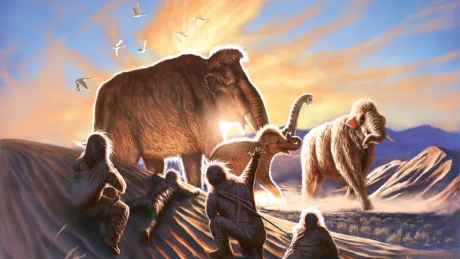
New analysis of a 14,000-year-old woolly mammoth tusk has pieced together the life of a female mammoth that likely died at the hands of hunters close to Alaska’s oldest archaeological site. Scientists have retraced the journey of a female woolly mammoth from her birthplace in present-day Canada to eastern central Alaska, where she met her end around 14,000 years ago at the hands of hunter-gatherers. The mammoth, whose name Élmayuujey’eh translates to “hella lookin” in the aboriginal Kaska language, was likely killed by early Beringian hunter-gatherers when she was 20 years old. Her existence is known thanks to a complete tusk discovered at Swan Point, one of the oldest archaeological sites in the Americas. Élmayuujey’eh, or Elma for short, was born toward the end of the last ice age in what is now the Canadian province of the Yukon, where she likely stayed for the first decade of her life. A new analysis of the mammoth’s tusk suggests she then set off across the frozen landscape, covering roughly 620 miles (1,000 kilometers) in under three years. “That’s a huge amount of movement for a single mammoth,” study co-author Hendrik Poinar, a professor of anthropology at McMaster University in Canada and the director of the McMaster Ancient DNA Center, said in a video released by the university. Elma trekked all the way into Alaska and eventually slowed down, Poinar said. Her remains indicate she was closely related to both a juvenile and a newborn woolly mammoth whose bones were also unearthed at Swan Point. The trio may have belonged to one of two matriarchal herds that roamed an area within 6.2 miles (10 km) of Swan Point, according to the study, published Wednesday (Jan. 17) in the journal Science Advances. To piece Elma’s life together, researchers split her tusk lengthwise and examined thin layers of ivory that formed like the rings of a tree trunk throughout her years. The proportion of different versions of chemical elements, or isotopes, in these layers contained valuable information about the mammoth’s diet and location, enabling the team to retrace her steps. The researchers also analyzed ancient DNA in Elma’s tusk and compared it with the remains of eight other woolly mammoths found in and around Swan Point, including the two youngsters. Their results revealed the mammoths belonged to at least two distinct herds that may have gathered in the region along with other mammoth herds — a congregation that would have attracted humans. “Indigenous hunters clearly saw that the mammoths were using this as a really important location for feeding,” Poinar said in the video. “The data to me suggest that these were Indigenous people that appreciated, looked at, loved these phenomenal beasts walking on this landscape. But it would make sense too, that in times of need, that you would kill them — a mammoth like that could provide food for a huge number of people over a long period of time.” Elma’s remains indicate she was in the prime of early adulthood and well nourished at the time of her death. She likely died in late summer or early autumn, which coincides with when humans would have set up their seasonal hunting camp at Swan Point and suggests she died at the hands of hunters, according to the study. Very little is known about the geographic movements and behaviors of woolly mammoths — or about how these animals interacted with early Americans — but stories like Elma’s can paint us a picture. “This analysis of lifetime movements can really help with our understanding of how people and mammoths lived in these areas,” co-author Tyler Murchie, a postdoctoral researcher and former member of the MacMaster Ancient DNA Center, said in a statement. “We can continue to significantly expand our genetic understanding of the past, and to address more nuanced questions of how mammoths moved, how they were related to one another and how that all connects to ancient people.” Reprinted from a Live Science article by Sascha Pare
IAFI 2023 YEAR-IN-REVIEW

A summary for our members and other interested people By Gary Ford, IAFI President, January 12, 2024 This is our 7th year preparing a Year-in-Review report for you, our members. We appreciate your continued support, friendship and membership. INSTITUTE MEMBERSHIP Our members provide most of our support and much of the reason for the various materials, activities and events we provide. In 1996, we started with 11 members. At the end of 2023, as we continue to recover from the pandemic, we have 648 members (489 memberships) from 20 states, British Columbia, Canada and Germany. INSTITUTE BOARD PROJECTS IAFI work activities occur at both the Institute Board of Director level and at the Chapter level. Projects at the Institute board level generally benefit more than one chapter or do work that all chapters might not be able to do by themselves. Listed below are some of the recent projects the Institute Board of Directors has worked on. The Education Committee is working with a contractor to develop three 20-minute floods videos for a 4th grade audience The Membership Committee is developing a catalog of speakers for the chapters to use for their member programs. A new membership tracking system has been developed which makes it easier to take care of our members. The Trail Advocacy Committee works closely with the National Park Service (NPS) Program Manager for the Ice Age Floods National Geologic Trail. The intent is to help the Trail Manager with projects related to the development of the Trail. We assisted with three NPS Sponsored Teacher Workshops this year: two in the Tri-Cities area and one in Spokane. Website and Newsletter: Our webmaster keeps our website (iafi.org) fresh and stimulating. He also, with support from the chapters, issues the Pleistocene Post Newsletter four times a year. ANNUAL MEMBERSHIP MEETING This year we had our first annual membership meeting and field trip since the pandemic started back in 2020. It was sponsored by the Puget Lobe Chapter with major assistance from the Lower Grand Coulee Chapter and was held in the Sun Lakes State Park area. Click here for a summary. 2023 CHAPTER PROGRAMS Outreach to inform and educate the public about the Ice Age Floods and their long-lasting impact on our area is a key part of the IAFI mission. Our local chapter programs are possibly the most effective way we meet this challenge. Three of the more important ways we help people learn about the Ice Age Floods are with lectures, field trips and hikes. Lectures – As we have moved beyond the pandemic, we have been able to again offer more in-person lectures with some viewed Zoom presentations. We had 50 in-person lectures attended by over 1642 people. Many more people viewed these lectures when they were posted on YouTube. Field Trips – We conducted 21 field trips with 586 attendees. Hikes – Three chapters sponsored 13 hikes with 163 attendees. CHAPTER PRESENTATIONS TO SCHOOL GROUPS AND SCIENTIFIC ORGANIZATIONS Lake Lewis Chapter: A number of people from the Lake Lewis Chapter help with education programs at The Coyote Canyon Mammoth Site (MCBONES) near Kennewick. Between April and October 2023, McBones hosted school classes or home school groups on 58 days, participated in 12 STEM (Science/Technology/Engineering/Math) events at elementary, middle and high schools, conducted 40 group tours, hosted 12 public tours, and did 7 youth group tours. That means that 1853 adults and 2242 kids were exposed to the story of MCBONES’ Coyote Canyon Mammoth Site and the ice age floods in 2023. Each presentation included the story of the floods usually including the IAFI map of the floods region. The connections between the floods and the mammoth are that the mammoth was buried in several layers of floods sediment (Touchet beds). There are erratic pebbles buried among the bones and the elevation of the bone bed is just over 1000 feet above sea level (about 650 feet higher than the Columbia River at the Tri-Cities). The calibrated radiocarbon date of death of the mammoth is approximately 17,449 years before present. We are studying the death and burial of a Columbian mammoth. We can’t tell people about that without including the floods story. This is a “Who Done It” story, and we have a suspect. Cheney-Spokane Chapter gave a talk to 84 sixth graders at Jefferson Elementary School in Spokane, WA. Also, conducted a program at STEM in March with 367 students. Glacial Lake Missoula Chapter helped with a Bozeman Science Camp. Had a day of classroom activities that discussed glaciers, ice ages, landscapes, climate change. Field trip day featuring Lake Missoula impacts to modern landscapes. Palouse Falls Chapter hosted the Geological Society of Oregon Country for three lectures and three days of touring about 600 miles of the channeled scablands. Had an information booth at STEAM (Science/Technology/Engineering/Arts/Math) night at Colton School. Lower Grand Coulee Chapter assisted with a geology presentation at the Ice Age Floods Fest at Dry Falls aimed at educating children on the Ice Age Floods story (350+ attendees) CHAPTER PRESENTATIONS AT COMMUNITY EVENTS Cheney-Spokane Chapter talked with 102 people at Spokane Outdoor Expo. Talked with 128 people at the Blue Waters Bluegrass Festival, Medical Lake, WA. Glacial Lake Missoula Chapter presented program to Five Valleys Land Trust banquet. Took Wildlife Film Festival Film makers on eastern loop. Featured lake Missoula Story at all stops. Featured Glacial country scenery shots. Columbia River Gorge Chapter made presentations to visiting Polish and German Marshall Fund delegations and led donated field trips for Bingen-White Salmon Rotary and Skyline Health Foundation. Lower Grand Coulee Chapter had a booth at the Quincy Farmer Consumer Awareness Day with IAFI talks and tours, videos and information displays. 250+ attendees. Palouse Falls Chapter conducted a tour at the Sandhill Crane Festival, had a booth at both the Wheatland Fair and the Palouse Empire Fair. Wenatchee Chapter participated in FCAD Farmer Consumer Awareness days in Quincy; also made a presentation at a Master Gardener Conference, 89 attendees. CHAPTER MEMBERSHIP APPRECIATION EVENTS Our members
Hello from the Ice Age Floods National Geologic Trail
Hello from the Trail. Congress created Ice Age Floods National Geologic Trail to educate visitors on the story of massive flooding towards the end of the last Ice Age in the Northwest. Its primary function is to grow connections between like-minded organizations and to increase public awareness and understanding across the four-state region. The Trail made progress during 2023, and some of the highlights include the development of our web-based interactive map, including an additional 70 flood site locations in our GIS database. Last year, we also joined fellow floods enthusiasts at multiple events, including the Ice Age Floods Institutes annual member meeting, the US Geological Society of America’s Penrose conference on glacial lake outburst floods, and numerous festivals and trade shows across the region. 2024 is shaping up to be another great year of sharing the story of the floods. We are looking forward to several trade show events in the Spokane area this winter, along with the Sandhill Crane Festival in March. This would be a great time to try out the NPS App. The Columbia Nation Wildlife Refuge includes Drumheller Channels Nation Natural Landmark, and the NPS App can help you navigate this area to features important to the Ice Age floods story. There are many unique places along the Ice Age Floods National Geologic Trail, and the Drumheller Channels are one of my favorites. I’ve had the chance to travel through sections of this magnificent landscape a couple of times and always find something new. Drumheller Channels are, for sure, part of the Channeled Scablands of Central and Eastern Washington State. This butte and basin landscape had as much as 400 feet of sedimentary and volcanic basement rocks torn away by the Missoula Floods, creating nine massive channels. Be sure to think about coming out to the Othello Sandhill Crane Festival March 22-24, 2024, where you can have some fun celebrating the return of 35,000 sandhill cranes and see the landscape that was forever changed by the Ice Age floods. As always, see you out on the Trail.
NORTH AMERICA’S FIRST PEOPLE MAY HAVE ARRIVED BY SEA ICE HIGHWAY

NEW RESEARCH SUGGESTS SOME EARLY AMERICANS MAY HAVE TRAVELED ON WINTER SEA ICE DOWN THE COAST FROM BERINGIA AS LONG AS 24,000 YEARS AGO One of the hottest debates in archeology is how and when humans first arrived in North America. Archaeologists have traditionally argued that people walked through an ice-free corridor that briefly opened between ice sheets an estimated 13,000 years ago. But a growing number of archeological and genetic finds — including human footprints in New Mexico dated to around 23,000 years old — suggests that people made their way onto the continent much earlier. These early Americans likely traveled along the Pacific coastline from Beringia, the land bridge between Asia and North America that emerged during the last glacial maximum when ice sheets bound up large amounts of water, causing sea levels to fall. Now, in research to be presented Friday, 15 December at the American Geophysical Union Annual Meeting (AGU23) in San Franciso, paleoclimate reconstructions of the Pacific Northwest hint that sea ice may have been one way for people to move farther south. The idea that early Americans may have traveled along the Pacific Coast isn’t new. People were likely south of the massive ice sheets that once covered much of the continent by at least 16,000 years ago. Given that the ice-free corridor wouldn’t be open for thousands of years before these early arrivals, scientists instead proposed that people may have moved along a “kelp highway,” where early Americans slowly traveled down into North America in boats, following the bountiful goods found in coastal waters. Archeologists have found evidence of coastal settlements in western Canada dating from as early as 14,000 years ago. But in 2020, researchers noted that freshwater from melting glaciers at the time may have created a strong current that would make it difficult for people to travel along the coast. Ice highway over dangerous waters To get a fuller picture of ocean conditions during these crucial windows of human migration, Summer Praetorius of the US Geological Survey and her colleagues looked at climate proxies in ocean sediment along the coast. Most of the data came from tiny, fossilized plankton. Their abundance and chemistry help scientists reconstruct ocean temperatures, salinity and sea ice cover. Praetorious’ presentation is part of a session on the climate history and geology of Beringia and the North Pacific during the Pleistocene at AGU23. The week-long conference has brought 24,000 experts from across the spectrum of the Earth and space sciences to San Francisco this year and connected 3,000 online attendees. Praetorious’ team used climate models and found that ocean currents were more than twice the strength they are today during the height of the last glacial maximum around 20,000 years ago due to glacial winds and lower sea levels. While not impossible to paddle against, these conditions would have made traveling by boat very difficult, Praetorius said. However, the records also showed that much of the area was home to winter sea ice until around 15,000 years ago. As a cold-adapted people, “rather than having to paddle against this horrible glacial current, maybe they were using the sea ice as a platform,” Praetorius said. Arctic people today travel along sea ice on dog sleds and snow mobiles. Early Americans may also have used the ‘sea ice highway’ to get around and hunt marine mammals, slowly making their way into North America in the process, Praetorius said. The climate data suggest conditions along the coastal route may have been conducive to migration between 24,500-22,000 years ago and 16,400-14,800 years ago, possibly aided by the presence of winter sea ice. While proving that people were using sea ice to travel will be tricky given most of the archeological sites are underwater, the idea provides a new framework for understanding how humans may have arrived in North America without a land bridge or easy ocean travel. And the sea ice highway isn’t mutually exclusive with other human migrations further down the line, Praetorius said. The team’s models show the Alaskan current had calmed down by 14,000 years ago, making it easier for people to travel by boat along the coast. “Nothing is off the table,” she said. “We will always be surprised by ancient human ingenuity.” Reprinted from American Geophysical Union web article
A TRIP TO THE MOUNTAIN TOP
Saddle Mountain is an asymmetrical anticline of the Yakima Folds which starts south of Othello, WA and extends west across the Columbia River. During the last glacial period, the diverted Columbia River worked its way south, west of Othello through the Drumheller Channels to the mountain and then flowed west along its base to its preflood location at Sentinel Gap. Periodic Missoula Floods roared down the Drumheller Channels and crashed head on, undercutting the north side of the mountain and then diverting around both ends of it. This undercutting along with tilted basalt layers and intersedimentary beds led to multiple landslides creating the Corfu Landslide Complex. At least one of the landslides extended to the top of the ridge and created the “saddle” that gives the mountain its name. Most people don’t know that the top of the mountain is accessible by a road from the south side. From SH 24 at MP 60.1, head north. At the “T” near the top, turn right and continue to the parking area at the turnaround. Walk east a short distance and you arrive at the saddle. To the north you have a great view of the Drumheller Channels, the Corfu Landslide Complex, and the course of the diverted Columbia River which now contains the underfit Crab Creek. To the south is the Hanford Reach area. Along the ridge on the south side of the road there are several concrete foundations. From 1955 to 1962, these were armed with Ajax and Hercules missiles ready to be launched at any enemy attack on Hanford. I met a worker from Boeing on one of my visits. He takes a trip to this isolated place twice a year to spend a weekend away from the hustle and bustle, noise, and light pollution of the big city. The top of the mountain is certainly a place of solitude and provides a great bird’s eye view of this part of our flood story. I am tentatively planning a Sandhills Crane bus tour this March to include this stop. Our chapter is also in the early stages of an extended weekend event that would also include it. by Lloyd Stoess, President of IAFI-Palouse Falls Chapter
Megaflood’s Impact on Spokane Valley
Views from Palisades and High Bridge Parks Palisades Park The Palisades Conservation Area encompasses 700 acres and provides a spectacular overview of the main Missoula floodpath through the Spokane Valley, which was then occupied by glacial Lake Columbia. The Park is at the top of a basalt bench historically referred to as rimrock and characterized by large boulders of fractured basalt undermined by the megaflood which widened Spokane Valley. In the far distance, well above the flood debacle, is Mt Spokane, highest peak in the Selkirk Range. This park’s trail system consists of a mixture of converted road bed and single trackways meandering through Ponderosa pines interspersed between flowered meadows, including seasonal wetlands, scour pools and isolated outcrops of columnar basalts, typical of megaflood erosion found in the Channeled Scabland. If you stick to the upper trail on top of the bench emanating westward along Rimrock Drive, you will see spectacular wildflower blooms in the spring and little elevation gain. For the more adventurous hiker, head south along Rimrock Drive and drop down 200 feet to Indian Canyon Mystic Falls, which cut into and expose pillow basalt found below the rimrock. Highbridge Park An exceptional cliff exposure of the Missoula megaflood deposit, which once filled the Spokane Valley, can be viewed along Latah Creek near the confluence with the Spokane River. This exposure can be viewed from an extensive gravel bar within Highbridge Park that can be reached by a short hike along a dirt road trail from the parking lot near the intersection of Riverside and Clarke Avenues. You can see within this 60-foot exposure of a cross-bedded megaflood deposit, visible channeling, gravel lenses (pinching in and out of channels), scour depressions and a big boulder filled channel just below the terraced surface. A small exposure of Mt. Mazama ash dating back to 7,700 years ago occurs at the top of this terrace marking the past elevation of Latah Creek. Standing at the confluence is Mike McCollum, who provided much helpful info about the flood features. Another reason to visit this site is that archaeologists excavated and recovered anthropological evidence that this flood gravel bar was a very important fishing site and gathering place for indigenous people for at least 8,000 years. We invite all the IAFI members to join us in early June for another multi-day Annual Fieldtrip Jamboree and we will even include these two parks in our agenda. So those of you who are interested in seeing the evidence suggesting that the Spokane Valley was carved out by the Missoula megafloods might want to sign up soon, space is limited. Who knows, but maybe our region’s flood history may not be that different from those of you residing in the Channeled Scablands after all. This article is a collaboration between IAFI Cheney-Spokane board members Dr. Linda McCollum, President; Jim Fox, Vice President; and Don Chadbourne Treasurer
Geographia: An Ancient Blueprint for Mapmaking

Many of history’s major breakthroughs were made by great thinkers standing on the shoulders of other intellectual giants, and Ptolemy’s Geographia, which builds on the scientific advancements of ancient Greek scholars, is no exception. The ancient Greeks were particularly skilled at understanding the world around them. By the fifth century BCE, the famous mathematician Pythagoras understood that the Earth was round, and it wasn’t long before Eratosthenes, another Greek scholar, accurately calculated the planet’s circumference. Centuries later, the Egyptian Greek scholar Ptolemy channeled all these scientific advancements into his masterwork, a collection of maps known as Geographia. Created around the year 150 CE, the eight-volume atlas served as a blueprint for mapmaking during the time of the Roman Empire. Ptolemy detailed the process of projecting a globe-shaped object onto a two-dimensional map, and pinpointed some 8,000 locations throughout Eurasia and northern Africa. He borrowed the concept of longitude and latitude from his mapmaking contemporary Marinus of Tyre, and built on it to make his own lasting contributions to cartography. Ptolemy’s work fueled many of the maps to come during the Islamic Golden Age and Europe’s Renaissance era. Reprinted from HistoryFacts.com article