OSU Archaeologists Find Oldest Known Projectile Points in the Americas

Oregon State University archaeologists have uncovered projectile points in Idaho that are thousands of years older than any previously found in the Americas, helping to fill in the history of how early humans crafted and used stone weapons. The 13 full and fragmentary projectile points, razor sharp and ranging from about half an inch to 2 inches long, are from roughly 15,700 years ago, according to carbon-14 dating. That’s about 3,000 years older than the Clovis fluted points found throughout North America, and 2,300 years older than the points previously found at the same Cooper’s Ferry site along the Salmon River in present-day Idaho. “From a scientific point of view, these discoveries add very important details about what the archaeologic al record of the earliest peoples of the Americas looks like,” said Loren Davis, an anthropology professor at OSU and head of the group that found the points. “It’s one thing to say, ‘We think that people were here in the Americas 16,000 years ago;’ it’s another thing to measure it by finding well-made artifacts they left behind.” Previously, Davis and other researchers working the Cooper’s Ferry site had found simple flakes and pieces of bone that indicated human presence about 16,000 years ago. But the discovery of projectile points reveals new insights into the way the first Americans expressed complex thoughts through technology at that time, Davis said. The Salmon River site where the points were found is on traditional Nez Perce land, known to the tribe as the ancient village of Nipéhe. The land is currently held in public ownership by the federal Bureau of Land Management. The points are revelatory not just in their age, but in their similarity to projectile points found in Hokkaido, Japan, dating to 16,000-20,000 years ago, Davis said. Their presence in Idaho adds more detail to the hypothesis that there are early genetic and cultural connections between the ice age peoples of Northeast Asia and North America. “The earliest peoples of North America possessed cultural knowledge that they used to survive and thrive over time. Some of this knowledge can be seen in the way people made stone tools, such as the projectile points found at the Cooper’s Ferry site,” Davis said. “By comparing these points with other sites of the same age and older, we can infer the spatial extents of social networks where this technological knowledge was shared between peoples.” These slender projectile points are characterized by two distinct ends, one sharpened and one stemmed, as well as a symmetrical beveled shape if looked at head-on. They were likely attached to darts, rather than arrows or spears, and despite the small size, they were deadly weapons, Davis said. “There’s an assumption that early projectile points had to be big to kill large game; however, smaller projectile points mounted on darts will penetrate deeply and cause tremendous internal damage,” he said. “You can hunt any animal we know about with weapons like these.” These discoveries add to the emerging picture of early human life in the Pacific Northwest, Davis said. “Finding a site where people made pits and stored complete and broken projectile points nearly 16,000 years ago gives us valuable details about the lives of our region’s earliest inhabitants.” The newly discovered pits are part of the larger Cooper’s Ferry record, where Davis and colleagues have previously reported a 14,200-year-old fire pit and a food-processing area containing the remains of an extinct horse. All told, they found and mapped more than 65,000 items, recording their locations to the millimeter for precise documentation. The projectile points were uncovered over multiple summers between 2012 and 2017, with work supported by a funding partnership held between OSU and the BLM. All excavation work has been completed and the site is now covered. The BLM installed interpretive panels and a kiosk at the site to describe the work. Davis has been studying the Cooper’s Ferry site since the 1990s when he was an archaeologist with the BLM. Now, he partners with the BLM to bring undergraduate and graduate students from OSU to work the site in the summer. The team also works closely with the Nez Perce tribe to provide field opportunities for tribal youth and to communicate all findings. The findings were published in the journal Science Advances. Reprinted from Oregon State University Newsroom, STORY BY: Molly Rosbach, SOURCE: Loren Davis
Ancient British Isles Ice Sheet Time-Lapse Animation

The rapid decline of the British-Irish Ice Sheet thousands of years ago may hold lessons for how melting ice sheets in Greenland and Antarctica will influence sea-level rise in the future. In an animation that spans tens of thousands of years, an ancient ice sheet grows to envelope land masses that would one day be known as Great Britain and Ireland. After thousands of years elapse, the ice then retreats to expose the land once more. Known as the British-Irish ice sheet, the frozen mass began its relentless march about 33,000 years ago. Around 10,000 years later, the land was covered in ice half a mile thick. But just 5,000 years after that, the glacier had melted away, vanishing in a mere blink of geological time. Human populations that had fled a millennia-long winter returned to settle the thawing land just as the last ice age drew to a close. Representing years of research, this animation highlights how quickly the British-Irish Ice Sheet declined. And the data driving the animation may help scientists to better understand how modern ice loss due to climate change contributes to sea-level rise.Scottish geologist Archibald Geikie first mapped the British-Irish Ice Sheet’s shape in 1894 and, over the past century, scientists have slowly carved out details of its formation and decline, publishing their findings in more than 1,000 scientific publications, according to the website of BRITICE-CHRONO(opens in new tab) a five-year, $4.2 million endeavor to map the British-Irish Ice Sheet. Ultimately it was the specter of human-caused climate change that drove one team of BRITICE-CHRONO researchers to bring together existing data and collect more; they published their findings Sept. 7 in the journal Boreas(opens in new tab). In creating the new animation, the scientists visualized the most complete picture to date of the ancient ice sheet’s rise and fall. The BRITICE-CHRONO team scoured prior studies and compiled data on more than 20,000 landforms that currently exist along the path of the ice sheet — from hill-like drumlins, or small ridges, to masses of soil and rock left behind by the moving glacier. The scientists then visited locations on land and sea, collecting data from 914 sites — some of which were only accessible via submarine, they reported in the study. They calculated the geometric contours of the ice sheet from features in the terrain, estimating the timing of the glacier’s retreat from carbon-dated sediment, including animal remains. Their efforts produced three times more data than any prior simulation of the British-Irish ice sheet; the team then fed the data into a computer model that assessed how the ice would have interacted with its environment over tens of thousands of years. Their animation presented the resulting maps as a time-lapse of the glacier’s expansion and eventual demise. Although this particular ice sheet melted thousands of years ago, the details of its growth and collapse may hold lessons for climate scientists studying the alarming decline of two modern ice sheets: one in Antarctica and the other in Greenland. Since 1901, these two ice sheets have lost 49,000 gigatonnes of ice — enough to coat the United States in 22 feet (6.7 meters) of ice, or enough to cover the entire surface of the moon in an ice sheet five feet (1.5 m) tall, according to NASA(opens in new tab). That melted ice ended up in the ocean, where it has been the single largest contributor to sea-level rise in the past few decades, according to the United Nations’ International Panel on Climate Change(opens in new tab). Even if humans were to cut all fossil fuel emissions tomorrow, a 2022 study in Nature Climate Change(opens in new tab) suggests that ice lost from the Greenland ice sheet would still cause a 10-inch (25-centimeter) sea level rise. Rising sea levels, in turn, will likely mean more punishing storms with worse flooding; the disruption of fragile ecosystems; and the mass displacement of millions of people who live along the coast. Projects such as BRITICE-CHRONO, which look back at the lifespans of long-gone ice sheets, may help scientists predict the decline of modern ice sheets and plan for the future, the researchers reported. Article by Joshua A. Krisch, taken from Live Science
Dry Falls and Channeled Scabland included in top 100 Geological Heritage Sites Worldwide

Bruce Bjornstad is honored to have his photo of Dry Falls from “Ice Age Floodscapes of the Pacific NW” featured in a just-released international publication coauthored by Susan Schnur and Ryan Karlson. “Dry Falls and the Channeled Scabland” is included as one of the “First 100 IUGS Geological Heritage Sites”, chosen by more than 200 experts and 10 international organizations from more than 40 countries. According to the International Commission of Geoheritage (IUGS) the 100 Geological Heritage Sites are “key places with geological elements and/or processes of scientific international relevance with a substantial contribution of geological sciences through history”. Here’s link to the free .pdf file of the publication that features all 100 sites, Dry Falls is #87: https://iugs-geoheritage.org/videos-pdfs/iugs_first_100_book_v2.pdf. Print copy to be available later. More info: https://iugs-geoheritage.org/geoheritage_sites/dry-falls-and-the-channeled-scabland/
Beacon Rock
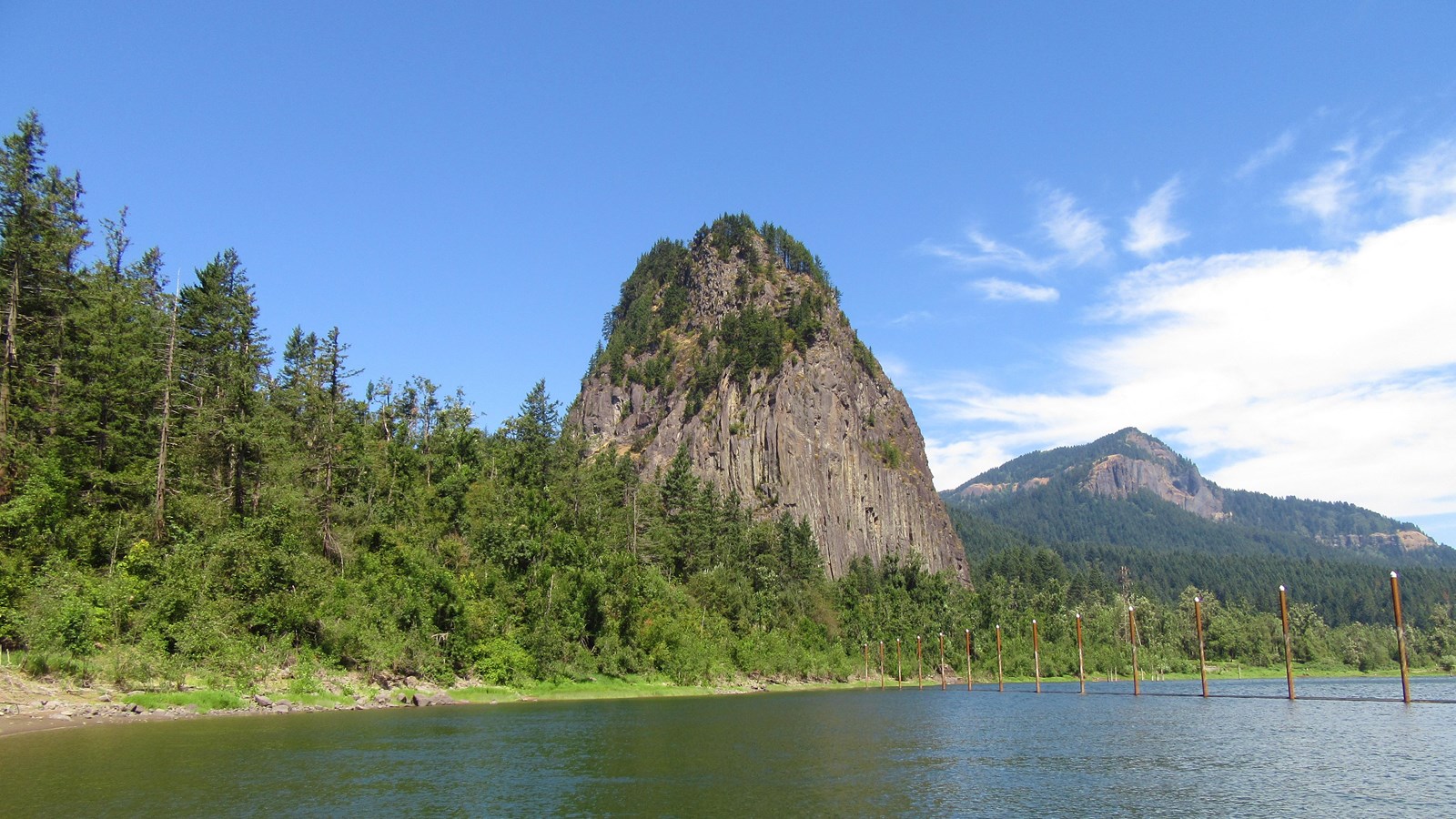
Beacon Rock Ice Age Floods National Geologic Trail, Lewis & Clark National Historic Trail Outside Skamania, Washington is the 848 foot-tall Beacon Rock that overlooks a breathtaking section of the mighty Columbia River. Beacon Rock State Park is a 4,464-acre, year-round camping park sitting in the midst of the Columbia Gorge National Scenic Area. The core of an ancient volcano, Beacon Rock is essentially a basalt plug; the Missoula Flood waters eroded away the softer outer material. Captain Clark wrote in his journals, “…a remarkable high rock on Stard. Side about 800 feet high & 400 yds round…” His estimates were exceptionally close. Today, the site is on the Lewis and Clark National Historic Trail’s list of High Potential Historic Sites. As the area was settled in the 19th century, the basalt feature was given a variety of names. By 1915, river developments threatened to destroy the rock. Henry J. Biddle, a prominent Washingtonian and descendant of Nicholas Biddle, the original editor of Lewis and Clark’s journals, bought it and eventually gave it to the state for a park, restoring the original name assigned by Clark. To get to the top, hike the mile-long switchback trail. Or for the more adventurous, you’ll enjoy rock climbing or hiking to waterfalls. Cyclists and horseback riders will find trails to outstanding vistas, and boaters will delight in the majesty of the area from the waters of the Columbia. The park includes 9,500 feet of freshwater shoreline and more than 26 miles of roads and trails. Picnicking and camping are also found at the park. The park is open daily from 8 a.m. to dusk. A Washington State Park Discover Pass is required and may be purchased at an automated station. The park is just two miles from Skamania on state highway 14. For more information: http://parks.state.wa.us/474/Beacon-Rock. Beacon Rock is a High Potential Historic Site on the Lewis and Clark National Historic Trail. On October 31, 1805, Clark described, “a remarkable high detached rock Stands in a bottom on the Stard Side near the lower point of this Island on the Stard. Side about 800 feet high and 400 paces around, we call the Beaten rock.” Significantly, Clark also noted the first evidence of tidewater: “I could not See any rapids below in the extent of my view which was for a long distance down the river, which from the last rapids widened and had every appearance of being effected by the tide.” The expedition revisited Beacon Rock returning upriver on April 6, 1806. Lewis wrote, “from the appearance of a rock […] I could judge better of the rise of the water than I could at any point below. I think the flood of this spring has been about 12 feet higher than it was [the previous fall]; the river is here about 1½ miles wide; it’s general width from the beacon rock which may be esteemed the head of tide water, to the marshy islands is from one to 2 miles tho’ in many places it is still wider. it is only in the fall of the year when the river is low that the tides are perceptible as high as the beacon rock. This remarkable rock which stands on the north shore of the river is unconnected with the hills and rises to the height of seven hundred feet; […] it rises to a very sharp point and is visible for 20 miles below on the river.” Beacon Rock is an eroded basalt volcanic plug that stands at approximately 848 feet. In the 1800s, it became known as Castle Rock. Purchased by Henry Biddle (a descendant of Nicholas Biddle) in 1915, he restored the Beacon Rock name, constructed a trail to the top, and donated it to the state of Washington. The landmark was designated a state park in 1935. Quick Facts MANAGED BY:Beacon Rock State Park
Cape Disappointment State Park

Cape Disappointment State Park Ice Age Floods National Geologic Trail, Lewis & Clark National Historic Trail, Lewis and Clark National Historical Park Located in Ilwaco, Washington, Cape Disappointment State Park is a 2,023-acre park located on the Long Beach Peninsula. With the Pacific Ocean to the west and a view of the mouth of the Columbia River, Cape Disappointment offers plenty of recreational opportunities and beautiful vistas. HistoryThe cape was named by Captain John Meares’ after his first failed attempt to find the Columbia River in 1788. Meriwether Lewis and William Clark would later conduct reconnaissance of this area during their stay at Station Camp from November 15 to November 24, 1805. TodayThe park provides many hiking opportunities, including 8 miles of trails leading through old-growth forest or around freshwater lakes and saltwater marshes. Additional outdoor activities include boating from Baker Bay, fishing at the North Jetty, or taking a walk on Benson Beach. Farther inland, visitors will enjoy wandering through the ruins of World War II era bunkers and coastal defense batteries, or exploring the North Head Lighthouse. The Lewis and Clark Interpretive Center is perched on the wind-swept cliffs 200 feet above the surf. The museum features a number of interactive exhibits focused on the area’s history, with special focus on the story of the Corps of Discovery’s journey, particularly on their Pacific Coast stay during the winter of 1805-1806. A series of mural-size timeline panels guide visitors through the westward journey of the Expedition using sketches, paintings, photographs, and the words of the journal writers. Cape Disappointment State Park’s operating hours vary by season. Visitors must purchase a park pass to enter the park, and there are additional admission fees for the interpretive center and the North Head Lighthouse Tour. For more information, visit Cape Disappointment State Park | Washington State Parks and Recreation Commission. Quick Facts Location:Ilwaco, WAMANAGED BY:Washington State Parks
Lewis and Clark Interpretive Center
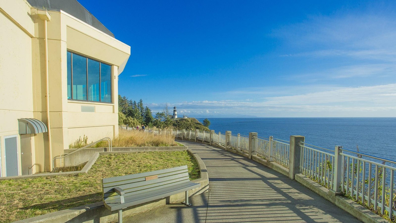
Lewis and Clark Interpretive Center Ice Age Floods National Geologic Trail, Lewis & Clark National Historic Trail English fur trader John Meares was mistaken as he stood on the northern shore of the mouth of the Columbia River in July 1788. He was in search of the great river, but what appeared before him seemed to be a large bay, so he named the high bluff above the Columbia’s mouth, “Cape Disappointment.” When you visit Cape Disappointment State Park today, you certainly won’t be disappointed in what you find. It’s an amazing park that’s home to the Lewis and Clark Interpretive Center. Perched on a cliff 200 feet above the pounding Pacific surf, the Lewis and Clark Interpretive Center shares the story of the Corps of Discovery’s journey, focusing particularly on their Pacific Coast stay during the winter of 1805-1806. A series of mural-size timeline panels guide visitors through the westward journey of the Expedition using sketches, paintings, photographs, and the words of the journal writers. It’s a wonderful stop for families with numerous interactive exhibits. Children can try to pack a canoe without tipping it, follow a treasure hunt, and check out what the Corps ate on their journey. The center features a short film presentation, a nicely outfitted gift shop, and a glassed-in observation deck with fabulous views of the river, headlands, and ocean. Additional displays focus on local maritime and military history. During winter and spring, trained volunteers come to the center to help visitors spot migrating Gray Whales. You can also learn about the nearby North Head and Cape Disappointment Lighthouses. The lighthouses both function to protect mariners from the rough and ever-changing Columbia River Bar in the treacherous area known as the “Graveyard of the Pacific.” The Cape Disappointment Lighthouse is the oldest operating lighthouse on the West Coast. Cape Disappointment was armed with smoothbore cannons to protect the mouth of the Columbia during the Civil War. In 1875, the area was expanded to become Fort Canby which remained in use through the end of World War II. Today, near the visitor center, you can explore the remains of the military bunkers and defense batteries. Be sure to set aside time to hike through old-growth forest or around fresh-water ponds, saltwater marshes, and ocean tidelands. The beaches are perfect for kite-flying, sand-castle building, or simply walking and exploring. Camping, picnicking, clamming, boating, fishing, crabbing, and bird watching are also fun activities within the park. Cape Disappointment State Park is open year-round for camping and day use, 8 a.m. to dusk. A Washington State Park Discover Pass is required. The hours of the Lewis and Clark Interpretive Center vary by season. Be sure to check their website for current rates, hours, and information: https://parks.state.wa.us/187/Cape-Disappointment. Quick Facts MANAGED BY:Cape Disappointment State Park
Columbia Hills State Park
COLUMBIA HILLS STATE PARK – DALLES MOUNTAIN RANCH Ice Age Floods National Geologic Trail, Lewis & Clark National Historic Trail Columbia Hills State Park is a Washington State Park located 6 miles east of Dallesport on SR 14 in Klickitat County. The park occupies 3,338 acres on Horsethief Lake, an impoundment of the Columbia River, and was created in 2003 with the merger of Horsethief Lake State Park and Dalles Mountain Ranch. It also includes Horsethief Butte and Crawford Oaks, both popular hiking areas. Horsethief Lake section of the Columbia Hills Historical State Park is a National Historic Site. Located on the site of a former Native American village, Columbia Hills State Park is along the rolling hills of the Columbia River Gorge, with nearly two miles of freshwater shoreline on the Columbia River. This made it the perfect stopping point for the Lewis and Clark expedition on their way to the coast. A group of significant Native American pictographs and petroglyphs are located in this area of the park. The Temani Pesh-Wa exhibit is open daily for self-guided viewing. The world-famous Tsagaglalal, (She Who Watches) and other pictographs and petroglyphs can be viewed by making a reservation to participate in a regularly scheduled ranger-led tour (see Interpretive Opportunities on website for registration instructions). Across Highway 14 from the main part of Columbia Hills State Park, Horsethief Butte dominates the skyline, standing over Horsethief lake like an ancient castle. The lake itself is enormous, flooded into existence by the construction of The Dalles Dam. Lupine and balsamroot bloom in mid-April, making spectacular fields of purple and gold. Songbirds flit about, while larger birds of prey — like eagles and falcons — soar on air currents high above your head. The commission combined the park with Dalles Mountain Ranch and renamed the area Columbia Hills State Park in 2003. Now, in addition to the more than 12 miles of hiking trails in the area, visitors can enjoy swimming, freshwater fishing, bird watching and wildlife viewing, sailboarding, and playing horseshoes. Rock climbers also frequent this park. Dalles Mountain is known for the spectacular wildflower displays in the spring. Quick Facts Location:Lyle, WA, MANAGED BY:Washington State Parks Quick Facts Location: Dalleport, WA MANAGED BY: Washington State Parks
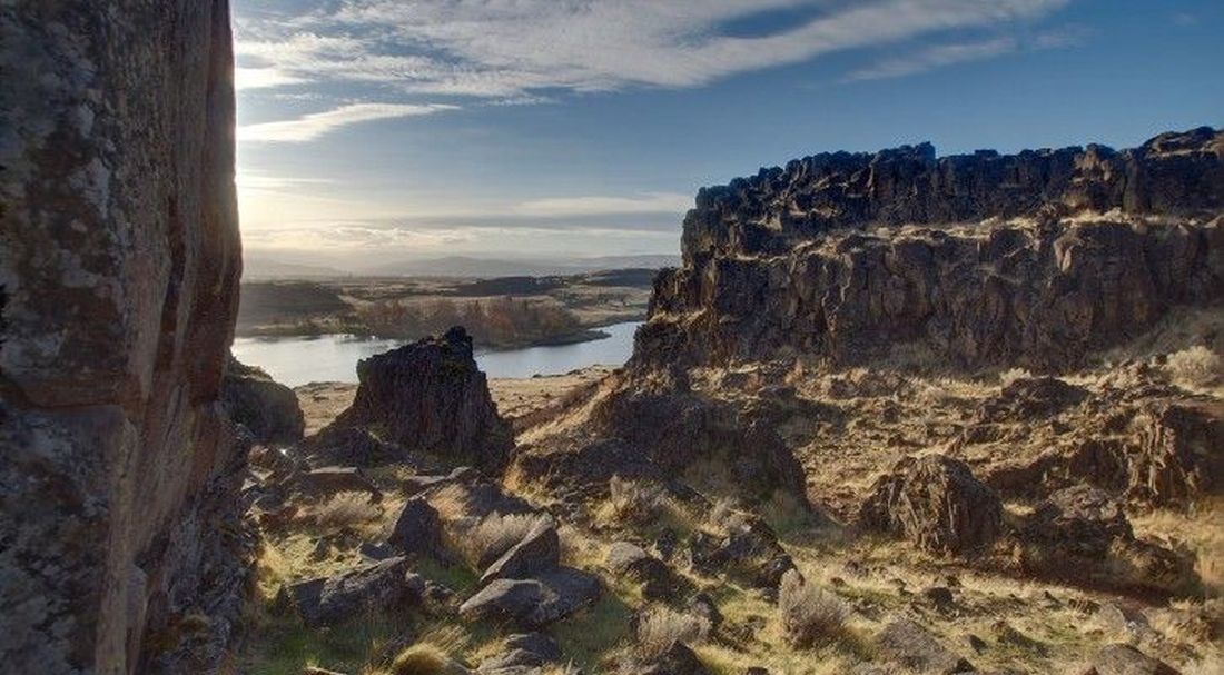
Drumheller Channels National Natural Landmark
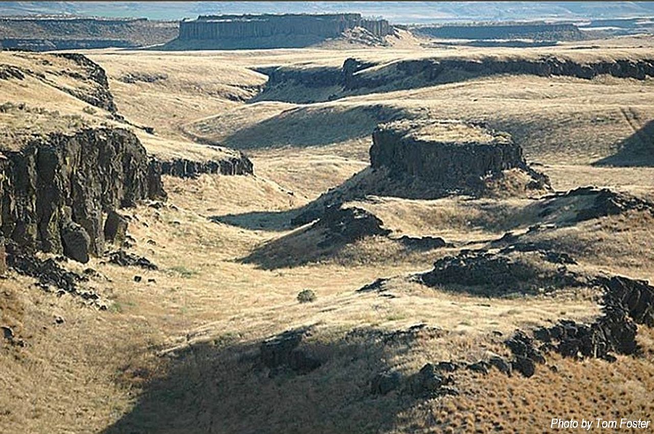
Drumheller Channels National Natural Landmark Ice Age Floods National Geologic Trail The Drumheller Channels are unique because no single channel or major cataracts were formed. The Drumheller Channels are the most spectacular example in the Columbia Plateau of basalt “butte-and-basin” channeled scablands. This is an erosional landscape characterized by hundreds of isolated, steep-sided hills surrounded by a braided network of (usually) dry stream channels. The landscape is the result of dramatic modification of the Columbia Plateau volcanic terrain by late Pleistocene catastrophic glacial outburst floods—the Missoula Floods. These floods occurred at a scale remaining unparalleled on earth, either in the geologic record or in historical account. During the last glaciation the Cordilleran Ice Sheet advanced southward at various times to impinge upon the northern margin of the Columbia Plateau. Occasionally, the Pend Oreille Lobe of the ice sheet plugged the Clark Fork River valley near the point where it now enters Pend Oreille Lake, Idaho. The resulting glacier-dammed lake (Glacial Lake Missoula) covered at its highest level an area of about 7,800 square kilometers (3,000 square miles) in western Montana and contained an estimated 2,100 cubic kilometers (500 cubic miles) of water with a depth of nearly 600 meters (2,000 feet) at the ice dam. At least 40 times, a violent collapse of the ice dam caused the waters of Glacial Lake Missoula to discharge rapidly downstream as catastrophic floods that spread across the flat basaltic terrain of the Columbia Plateau within a period of two or three weeks each time. Although the precise number of floods remains in question (i.e. as many as 100 have been proposed), the incredible proportions of flood-related land-forms on the plateau bear witness to the largest and most catastrophic of such events known to have occurred on the face of the earth, both in the geologic record and in historical account. Upon reaching the Columbia valley, and blocked by the Okanogan Lobe of the ice sheet, the flood waters backed up and spread across the Columbia Plateau, spilling through the Grand Coulee and several other channel ways to the east in the upper Crab Creek drainage. Flowing south and westward, the water ponded in the Quincy Basin and then spilled partly into the Columbia valley to the west in three channels. In addition, a slight down warp in the volcanic flows of the plateau in the southeast corner of the basin funneled the majority of flood water southward into Drumheller Channels, a structural saddle between the plunging Frenchman Hills anticline on the west and the upward tilting plateau to the east. During the first floods through the channels, the waters plunged 10 meters/kilometer (50 feet/mile) for thirteen kilometers (8 miles), which provided the torrent with sufficient energy to tear away great masses of sedimentary and volcanic basement rocks: as much as 120 meters (400 feet) in some areas. Thick layers of the Plio-Pleistocene Ringold Formation (sandstones, siltstones, and clays representing stream deposits of an earlier Columbia River) were removed. In one spillway at least one flood spread over a 15 kilometer (9 miles) wide area and was more than 30 kilometers (100 feet) deep, carrying more than 400 cubic kilometers (100 cubic miles) of water at velocities up to 80 kilometers/hour (50 miles/hour). The unusual landscape carved by the floods is characterized by hundreds of buttes separated from one another by a labyrinth of small, anastomosing dry channels and basins and so is termed “basin-and-butte scabland”. Total relief in this tract of about 13 by 13 kilometers (8×8 miles) is 180 meters (600 feet). Six (6) main channels comprise the Drumheller Channels. A dramatically under-fit Crab Creek flows through the relatively wide, shallow center channel, while the others are pock-marked with rock basins and potholes. All wind southward toward the Othello Channels to the southeast and the Lower Crab Creek valley to the southwest. Other related scabland systems on the Columbia Plateau include the central Grand Coulee, the Sprague Channeled Scabland, the Rattlesnake Springs scablands of Moses Coulee, and other areas south of Cheney, Washington. Prior to the development of the Columbia Basin Irrigation Project, the rock depressions of the Drumheller Channels was largely dry and supported sage-bunchgrass vegetation. Over one hundred lakes now occur within the site as a result of the impoundment of Lower Crab Creek in 1950, the consequent creation of the Potholes Reservoir to the north, and a concomitant rise in the ambient water table. As a result, more diverse flora and fauna now occur within the region. Eight (8) habitat types have been identified within Columbia National Wildlife Refuge, including sagebrush, grassland, greasewood, cliff, willow woodland, sedge meadow, marsh, and lake.Drumheller Channels has become a resting, feeding, and wintering ground for twenty-three species of ducks and geese; occurrences of other water birds have increased as well. So striking and extreme is this landscape that in 1986, the National Park Service designated the Drumheller Channels National Natural Landmark. National Natural Landmarks recognize sites that contain outstanding biological and/or geological resources, regardless of landownership. They are selected for their outstanding condition, illustrative value, rarity, diversity and value to science and education. In fact, so important and unique are the Missoula Floods and the resulting landscapes that Congress has designated the Ice Age Floods National Geologic Trail. More Information can be found at: Washington Department of Natural Resources – Washington Geologic Survey (WA 100) National Natural Landmarks – National Natural Landmarks (U.S. National Park Service) (nps.gov) Columbia National Wildlife Refuge – Columbia – U.S. Fish and Wildlife Service (fws.gov) Quick Facts Location:W McManamon Rd, Othello, WA 99344 Designation:National Natural LandmarkMANAGED BY:Columbia National Wildlife Refuge
Ginkgo Petrified Forest National Natural Landmark

Ginkgo Petrified Forest National Natural Landmark Did you know that petrified wood is Washington’s official state gem? Considered one of the most diverse fossil forests in North America, Ginkgo Petrified Forest State Park is famous for its rare specimens of petrified Ginkgo tree discovered there in 1932. Curious? Drive to the park interpretive center and take in the big skies, Columbia River views and outdoor exhibits of petrified wood. Look for evidence of Ice Age Floods carved into the walls of the Columbia River. Then step inside the Ginkgo Petrified Forest Interpretive Center which features more than 30 varieties of petrified wood, including a display of rare ginkgo petrified wood. Drive the Old Vantage Highway to the Ginkgo “trailside museum,” constructed by the Civilian Conservation Corps in the 1930s, and recently updated with a new interpretive exhibit. From here, the Trees of Stone Interpretive Trail winds past more than 20 petrified logs in their original settings. Birders, look for golden eagles, sage thrashers, Say’s phoebes and many other species. Elk and bighorn sheep also frequent this area. You may want to reserve a campsite at nearby Wanapum Recreation Area so you can cap off a hot day with a refreshing swim or boat float in Wanapum Lake (a reservoir on the Columbia River). Pitch your tent or connect your RV, make a picnic under a shady tree, and savor this green oasis. PARK FEATURES Ginkgo Petrified Forest State Park is a 7,124-acre park with camping at Wanapum Recreation Area. The park features 27,000 feet of freshwater shoreline on the Wanapum Lake along the Columbia River. Ginkgo Petrified Forest is a registered National Natural Landmark. Ginkgo Petrified Forest State Park is comprised of three primary locations. See tabs below for more information on specific opportunities within each area of the park. Wanapum Recreation Area hosts a campground, boat ramp and ample day-use area with a swim beach. Ginkgo Petrified Forest Interpretive Center offers day-use picnic areas, exterior displays and an interpretive facility. The Trailside Museum and Trees of Stone Interpretive Trail include signage about the petrified wood and 1.25 miles of trail that weave through petrified logs in their original setting. A total of 3 miles of hiking trails are at this site. Automated pay stations: This park is equipped with automated pay stations for visitors to purchase a one-day or annual Discover Pass and boat launch permit. Electric-vehicle charging station: The park offers a solar-powered EV charging station at no cost to users. Learn more about this charging station. Quick FactsOn the Ice Age Floods National Geologic TrailLocation:4511 Huntzinger Road Vantage, WA 98950 MANAGED BY:Washington State Park
Lyons Ferry State Park

Lyons Ferry State Park Ice Age Floods National Geologic Trail If eastern Washington calls to you, Lyons Ferry State Park is sure to enthrall. Tree-shaded green lawns gracefully slope to the cooling waters of the Snake and Palouse rivers. The hills of the Palouse, on a landscape carved by powerful Ice Age Floods, lie beyond the water. This day-use park also may awaken your inner historian: In addition to its interesting geology, the park was long home to Native people, including the Palouse Indian Tribe. Its history includes a visit by the 34-member Corps of Discovery that included Lewis and Clark, on their westward journey in October 1805. Later in the 19th century, the park became the site of a ferry crossing that served the area for more than 100 years. For those who want to relax and enjoy, the wide spot on the rivers is a lure for picnickers, boaters, swimmers and water sports fans, as well as anglers casting out for the catch of the day. Nearby Palouse Falls State Park offers spectacular views of Washington’s state waterfall. For more land-based activities in the area, bring bikes and ride the Columbia Plateau State Park Trail from Ice Harbor Dam to the Snake River Junction. Camping is available at Lewis and Clark Trail State Park 45 minutes away. PARK FEATURES Lyons Ferry is a 168-acre day-use park with more than 52,000 feet of shoreline at the confluence of the Snake and Palouse rivers. Lyons Ferry was named after the Lyons family, who for many years operated the ferry across the Snake River. The ferry service ran from 1860 to 1968, when it was replaced by a bridge. Discover Pass: A Discover Pass is required for vehicle access to state parks for day use. For more information about the Discover Pass and exemptions, please visit the Discover Pass web page. Quick Facts Location: 620 Marmes Road Washtucna, WA 99371 MANAGED BY:Washington State Parks Discover Pass: A Discover Pass is required for vehicle access to Washington State Parks for day use. For more information about the Discover Pass and exemptions, please visit the Discover Pass web page.