 The Bowl and Pitcher is a rock formation along the Spokane River and one of the most scenic sites in the area, with basalt cliffs rising 500 feet above the river and large blocks of basalt in the river causing large rapids. The “Bowl” is a circular depression in the river and the “Pitcher” is a large detached block of highly fractured basalt. The geology of Spokane’s Bowl and Picher features dramatic basalt cliffs carved out of the flows from the Columbia River Basalt Group (CRBG), which reached this area 16 million years ago. There are river and flood deposits of sand and gravel, with granitic boulders forming terraces on the east side of the river, and huge blocks of basalt, causing the Dragon Tooth rapids, downriver from the Bowl and Pitcher. How did those rocks get there?
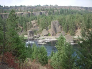
The Spokane and Columbia rivers occupy a long, mostly bedrock canyon near the northeastern boundary of the Columbia Plateau. Glacial Lake Columbia, which formed behind the Okanogan ice lobe, occupied all of the Spokane River and a portion of the Columbia drainage basin during the last Ice Age. Then the glacial Lake Missoula outburst floods first surged over the Columbia Basin beginning around 17,000 years ago, ripping away the CRBG and other bedrock from Bayview, Idaho, to the Pacific Ocean. These floods also deposited a thick sequence of flood gravel in the valley. As Lake Columbia water level dropped, the Spokane River began to remove the sand and gravel fill. Subsequent floods continued to remove the flood deposits, leaving the basalt benches on the west side of the river and the terraces on the east side.
Riverside State Park is located northwest of Spokane and consists of over 9000 acres along the Spokane and Little Spokane Rivers. The park is the second largest state park and has many recreational activities including, camping, hiking, mountain biking, horseback riding and boating (Discover Pass required). There are two view points for the Bowl and Pitcher. The first is from a small parking lot off the entrance road from Aubry White Parkway that provides an elevated view of the site. The main parking area is down along the river with a picnic area and a network of trails. From the parking lot you can follow the wheelchair accessible path across the suspension bridge over the Spokane River. From the bridge you can enjoy a view of the features that give the site its name. The original bridge was built in 1942 by the Civilian Conservation Corps. The existing bridge, based on the same plans, opened in 1998. On the west side of the river, you can access a network of trails along the river or climb up along the bluffs above the river.