
Developing an Ice Age Floods Animation Through Science, Partnership, and Interpretation
Explaining the Missoula Floods has never been simple.
The floods reshaped landscapes across much of the Pacific Northwest, yet they occurred thousands of years ago, unfolded repeatedly rather than once, and operated on a scale that is difficult to grasp from any single viewpoint. While physical evidence of flooding is visible in coulees, erratics, and sediment deposits across the region, understanding how those features formed requires connecting processes that span vast distances and long periods of time.
For the Ice Age Floods National Geologic Trail, this challenge sits at the center of its mission. The Trail links flood-related sites across four states and relies on partnerships with parks, museums, educational institutions, Tribes, and communities to interpret a story that is regional in scale and national in significance. Developing a shared, accurate way to tell that story has been a long-standing goal.
One important step toward that goal is the release of a new Ice Age Floods animation, now publicly available through the Pleistocene Post for the first time ever through the National Park Service and the Ice Age Floods Institute.
Understanding the Missoula Floods—and Why Animation Was Essential
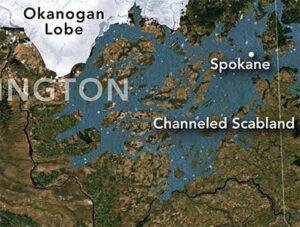
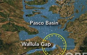
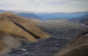
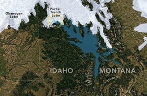 The Missoula Floods were not a single catastrophic event. They occurred dozens of times as an ice dam repeatedly formed and failed during the last ice age. Each flood released immense volumes of water, carving the Channeled Scablands, transporting massive boulders, and depositing thick layers of sediment across the Columbia Basin, the Willamette Valley, and beyond. These repeated events reshaped landscapes on a scale that is difficult to grasp from any single location or landform.
This combination of repetition, scale, and process presents a fundamental interpretive challenge. Static maps, photographs, or diagrams can show where flooding occurred, but they struggle to convey where ice dams formed and failed, why floods happened repeatedly, and how those repeated events shaped the landforms we see today. Visitors often encounter individual features—such as coulees, erratics, or sediment deposits—without an intuitive sense of how those features connect to a larger, system-wide story.
Animation offers a way to bridge that gap by showing movement, change, and sequence over time. It makes it possible to illustrate how ice dams failed, how floodwaters moved across vast landscapes, and how erosion, transport, and deposition shaped the region over thousands of years. By showing sequence and scale together, the animation provides context that static interpretation often cannot.
At the same time, animation carries risks. Visual storytelling can unintentionally oversimplify complex processes or imply certainty where scientific understanding includes ranges and ongoing inquiry. Addressing those risks required careful collaboration and review to ensure the final product communicates current scientific understanding clearly, accurately, and responsibly.
A Trail Built on Partnership
The Ice Age Floods National Geologic Trail is a partnership-based unit of the National Park Service. Unlike traditional national parks, the Trail does not center on a single land base. Instead, it connects a network of sites, organizations, and communities that collectively interpret the Missoula Floods story across four states.
From its earliest days, scientific research and public education about the floods have been advanced by regional partners, particularly the Ice Age Floods Institute, along with academic researchers, museums, educators, and land managers. Federal agencies with expertise in geology, hydrology, and landscape science have also contributed to the evolving understanding of flood processes and landforms. Together, these partners built the scientific foundation and public awareness that ultimately made the Trail possible.
That shared foundation shaped how the Ice Age Floods animation was conceived. The project was not approached as a standalone National Park Service product, but as a collaborative effort intended to reflect current scientific understanding while respecting decades of research, publication, and public engagement. Partner involvement helped ensure the animation was grounded in credible science and responsive to the needs of educators, interpreters, and institutions working across the region.
Just as important, partners helped shape how the animation would be used. From the outset, it was understood that no single product could replace place-based interpretation. Instead, the animation needed to complement local stories, support diverse interpretive goals, and function as a shared framework rather than a prescriptive narrative.
The result is an animation designed to be flexible, modular, and broadly applicable.
A Collaborative Development Process
Developing the animation was an iterative process involving scientists, interpreters, educators, and media specialists. Expertise in glacial dynamics, flood hydraulics, geomorphology, and interpretation informed each stage of development, ensuring that both scientific rigor and interpretive clarity remained central throughout the project.
Drafts were reviewed not only for technical accuracy, but for how audiences might reasonably interpret what they were seeing. Revisions focused on clarity and defensibility—refining pacing so that scale was conveyed without exaggerating velocity, ensuring viewers could distinguish between process and outcome, and reinforcing that the floods occurred repeatedly rather than as a single event.
In many cases, refinements were not about correcting facts, but about improving how those facts were communicated visually. The goal was not to resolve every scientific nuance, but to present a version of the story that is accurate, carefully framed, and useful across many interpretive settings. This collaborative approach helped ensure the animation could serve as a reliable interpretive tool while remaining accessible to broad public audiences.
What the Animation Is—and Is Not
The Ice Age Floods animation is intended to provide a system-scale overview of how the floods worked, support education and interpretation across diverse settings, and serve as a shared visual reference for partners and educators. It is not intended to replace place-based interpretation, resolve all scientific debates, or function as a comprehensive instructional resource on its own.
In many cases, individual segments of the animation may be more useful than the full piece. Short sections can illustrate specific topics—such as basalt erosion, flow through constricted valleys, or the cumulative effects of repeated flooding—while local interpreters focus on the features and stories most relevant to their sites.
Supporting Education and Public Understanding
Now that the animation is publicly available, it can support a wide range of educational and interpretive efforts, including:
- Visitor center and museum orientation
- Guided hikes and ranger programs
- Classroom instruction and teacher workshops
- Public talks and community presentations
- Digital exhibits and online learning
Because the animation is in the public domain, partners are free to share it and incorporate it into appropriate settings. The National Park Service can also provide access to links or clips from specific segments to support more targeted use.
Organizations interested in using the full animation or selected segments, or in discussing ideas for interpretation and education, are encouraged to contact the Ice Age Floods National Geologic Trail Program Manager, Justin Radford, at Justin_Radford@nps.gov.
A Shared Achievement
The release of the Ice Age Floods animation reflects what partnership makes possible. It brings together science, interpretation, and education to help audiences better understand one of the most dramatic geologic stories in North America.
Most importantly, it provides a shared starting point—one that partners across the region can use, adapt, and build upon as they continue to help people explore and appreciate the landscapes shaped by the Missoula Floods.