
Every geologist has a secret superpower: the ability to look at a cliffside or a pile of river rocks and read the ancient stories locked inside. But an even greater superpower is translating those stories into a tale so vivid that anyone can picture the world as it once was. On a recent field trip up the Klickitat River Canyon, we stopped in front of a roadside outcrop that holds a chapter of a truly cataclysmic story.
Where the Ice Age Floods Ran Backward 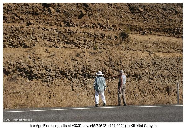 – Imagine a wall of water hundreds of feet high, thick with mud and carrying boulder-sized rocks, roaring down the Columbia River Gorge. As this massive torrent surged toward the Pacific, the deluge was so vast that it couldn’t fit within the main river channel. Instead, water violently backed up into every side canyon it passed—including the Klickitat River Canyon. Looking closely at this roadside cliff, you can see the clear evidence of this chaos:
- Layer 1: The Surge. A massive 6- to 10-foot-thick layer of jumbled mud and rounded boulders—debris carried by Ice Age Floods that slammed into the canyon as they surged up from the mainstem of the Columbia River.
- Layer 2: The Settling. A smooth, 1- to 2-foot layer of fine mud on top, settling out as the flood temporarily crested, possibly for days, as the flood waters continued to rampage through the Columbia Gorge, before the flood waters slowly drained back into the main Columbia River channel.
- Layer 3: The Repeat Performance. A second matching set of thick boulders and fine silt directly above the first—proof that this monstrous event happened more than once.
Right at the top sits a third layer of mixed angular and rounded rock that could also mark a third flood that carried some much more local debris, or perhaps it marks a volcanic mudflow (a lahar) that raged down-canyon from nearby Mt. Adams sometime after the previous floods subsided.
Unlocking the Flood Depth – How deep were these apocalyptic floods? The rocks hold some clues:
- 315 Feet Deep in the Canyon: The roadside outcrop described above sits at an elevation of ~330 feet—over 300 feet above the current bed of the Columbia River at the mouth of the Klickitat. To deposit these large boulders, the rampaging floodwaters had to run up the canyon to that elevation, at least 315 feet above the base of the main Columbia River at the Klickitat mouth.
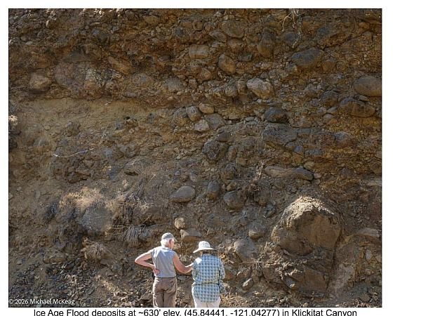
- Over 600 Vertical Feet and 8.7 Miles Further Upriver: 8.7 miles further up the Klickitat, we spotted similar flood deposits sitting at an elevation of 630 feet, implying that that main flood flowing through the Columbia was at least 615 feet deep.
- A Record of an 800+Foot Deep Flood: Immediately across the Columbia River at Rowena Crest, a visible “trimline” scoured into the landscape suggests the absolute largest floods crested there at 840 feet in elevation—implying an astounding flood depth of roughly 825 feet.
Because the narrow walls of the Klickitat Canyon created friction and drag against the invading water, the back-flooding in the side canyons like the Klickitat likely couldn’t reach the full height of the main river’s crest. But even considering that drag, standing next to these roadcuts and looking up, it is humbling to realize that thousands of years ago, you would have been standing hundreds of feet beneath a churning flood of mud-saturated water and transported rocks, some of them possibly from as far away as western Canada.
Article by Lloyd DeKay (editing assist by Gemini )