An Ice Age Floods Animation Developed Through Science, Partnership, and Interpretation
Imagine explaining a geological event so massive it reshaped the entire Pacific Northwest—not once, but dozens of times—across landscapes spanning four states. Now there’s a powerful new tool to help tell this remarkable story.
The Ice Age Floods National Geologic Trail has just released a groundbreaking animation that brings these ancient cataclysms to life. Available now through the National Park Service and the Ice Age Floods Institute, this public-domain resource represents years of collaborative effort between scientists, educators, and park partners.
Why Animation Was Essential

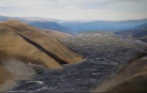
The Missoula Floods weren’t a single disaster—they occurred dozens of times during the last ice age as ice dams repeatedly formed and failed. Each flood carved the Channeled Scablands, transported house-sized boulders, and deposited thick sediment layers across the region.
The challenge? Physical evidence is scattered across vast distances, and static maps can’t capture the movement, scale, and repetition that defined these events. Visitors see individual features—coulees, erratics, deposits—without understanding how they connect to a continental-scale story unfolding over thousands of years.
Animation bridges this gap by showing how ice dams failed, how floodwaters surged across landscapes, and how repeated flooding shaped what we see today.
A Collaborative Achievement
Scientists specializing in glacial dynamics, flood hydraulics, and geomorphology worked alongside interpreters and media specialists through multiple reviews, balancing scientific accuracy with public accessibility. The result is a flexible, modular tool designed for visitor centers, classrooms, ranger programs, and online learning.
Because it’s in the public domain, partners can freely adapt segments for their specific needs—whether illustrating basalt erosion or the cumulative effects of repeated flooding.
Why This Matters
The Missoula Floods represent one of North America’s most dramatic geological events, yet they’ve remained difficult to comprehend. This animation finally provides a shared visual framework that makes the story accessible while honoring the complex science behind it—offering an unprecedented window into the forces that carved the Pacific Northwest.