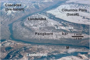
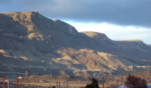
The east bank of the Columbia River near Malaga, Washington, is home to one of the largest and most visually striking landslides in the Pacific Northwest: the Malaga Slide. Covering an estimated 45 square miles, this massive slope failure poured weakened basalt and sediment into the Columbia River valley at the close of the last Ice Age. Today, it remains easily visible from State Route 28, making it an accessible outdoor classroom for geology enthusiasts and tour participants.
The geologic story of the Malaga Slide is a tale of both slow preparation and sudden catastrophe. Layers of basalt from the Columbia River Basalt Group were fractured and weathered over millions of years. Interspersed with weaker sedimentary layers, these formations became prone to failure. Add in groundwater saturation, the erosive power of repeated Ice Age Floods, and over-steepened valley walls, and the stage was set for a massive collapse.
Scientists believe the main phase of the Malaga Slide occurred approximately 15,000–13,000 years ago, during the final stages of the Missoula Floods. While the collapse itself was sudden, the landslide likely continued to adjust and move over time, creating the hummocky terrain and displaced boulders still visible today.
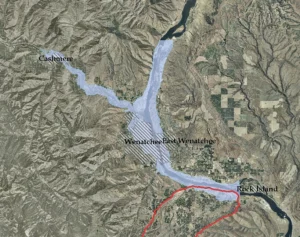
One of the most intriguing aspects of the Malaga Slide is its interaction with the Columbia River. Some geologists have hypothesized that the massive slide may have temporarily blocked or partially dammed the river. This could have caused short-term ponding upstream, potentially extending back toward Peshastin. Evidence of this interaction remains visible today as enormous boulders and slide debris in the river channel.
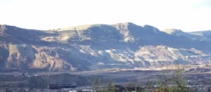
Travelers heading south from Wenatchee on State Route 28 are treated to a dramatic view of the slide, with scarred slopes and scattered boulders lining the west side of the river. This visibility makes the Malaga Slide an outstanding site for guided geology tours offered by the Wenatchee Valley Erratics Chapter of the Ice Age Floods Institute. Participants learn about Ice Age Flood processes, landslide mechanics, and the long-term evolution of the Columbia River valley.
Learn more about Wenatchee-area geology tours: https://wverratics.org or contact@wverratics.org
Article by Jeff Becklund, Wenatchee Valley Erratics Chapter President