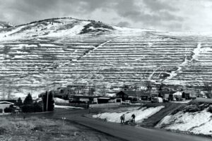
Glacial Lake Missoula Strandlines
Glacial Lake Missoula Strandlines Ice Age Floods National Geologic Trail Imagine you are standing on the edge of glacial Lake Missoula 15,000 years ago. You can hear lapping waves cutting benches known as “strand-lines” into the shoreline. Today, you can see these huge strand-lines on hills surrounding Missoula, Montana, marking changes in lake level over time. On Mount Sentinel, marked with an “M”, and Mount Jumbo, marked with an “L”, the strand-lines are seen as horizontal lines in the vegetation or highlighted by snow in the winter. Public hiking trails switchback through the strand-lines on Mount Sentinel and Mount Jumbo. Ancient shorelines or strand-lines of Glacial Lake Missoula are visible as perfectly parallel horizontal benches on hillside slopes around Missoula. They are most visible with light snow cover, or in low evening light on the mountains marked with an”M” and an “L” on either side of Hellgate Canyon looking east from the downtown. These shoreline benches cut by wave action in the lake recorded various lake levels as the ice dam blocking the Clark Fork River far upstream on the Idaho border repeatedly failed and refilled 40 times or more. It may be that as the ice-age waned each successive ice dam that reformed was smaller and failed under less pressure from a lower lake level than the one before, leaving behind its bench as a record of the successively lower ancient lake shorelines. It’s also possible they record winter still-stands in rising lake levels over time. Quick Facts Location:The Kim Williams Trail at Van Buren and 5th Street leads from the U Montana campus along the river between the mountains. To reachhigh water markers on the mountains see the Interactive Map or go to GlacialLakeMissoula.org