Cheney-Spokane Chapter Fishtrap Lake Scablands Hike

Fishtrap Lake South Loop

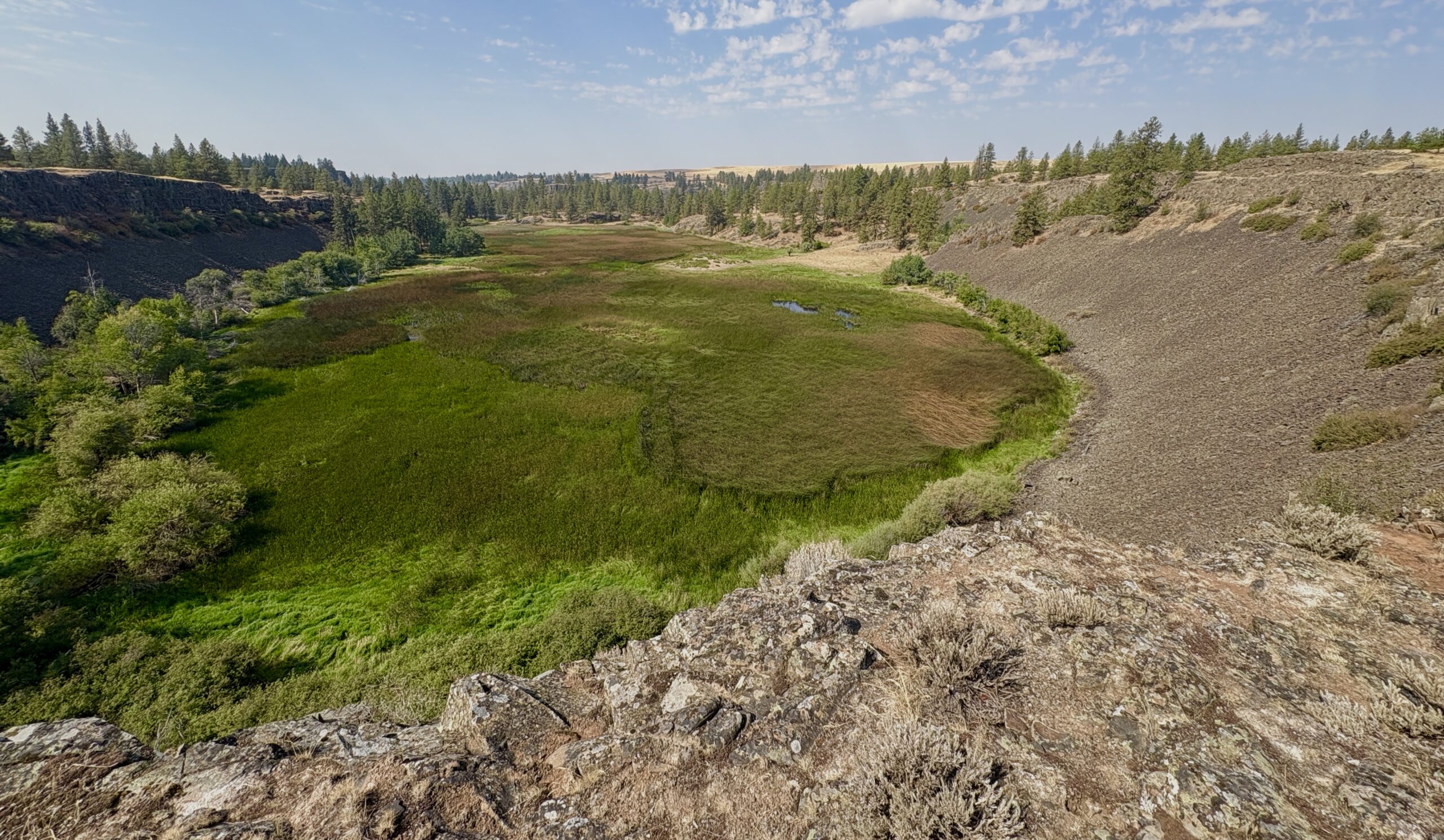
Fishtrap Lake, Washington (BLM Photo) Come join us for a 5-mile hike to explore the Ice Age floods features in the Fishtrap Lake area east of Sprague, WA! The Cheney-Spokane Chapter of the IAFI is scheduling a hike at the south loop trailhead of Fishtrap Lake on Saturday, October 26th . The hike will start at 10:00 a.m. The hike will be led by Don Chadbourne, geologist and board member of the Cheney-Spokane Chapter. You will meet the leader at the trailhead. Description of Fishtrap Lake Hike The hike will begin and end at the south trailhead at Fishtrap Lake. The hike will follow the south loop trail, with a total length of about 5.5 miles. The trail is mostly single track over dirt and rock, with an elevation gain and loss of about 500 feet. The hike will provide an intimate view of the channeled scablands that were carved out by the ice age floods. Features will include pothole lakes, rock benches, mima mounds, kolks, and streamlined and scarped Palouse hills. The hike will also provide wide open views of Fishtrap Lake and the surrounding country. This hike is included in On the Trail of the Ice Age Floods – Northern Reaches, by Bjornstad & Kiver. However, we will be following trails that were constructed after the book was published. Directions to the trailhead From I-90 take Exit 254 and proceed south 3.6 miles on the Sprague Highway. Turn left (east) on Miller Ranch Road and proceed 0.2 miles to the “T” at the Miller Ranch house. Turn right(south) and drive 0.8 miles to the trailhead parking lot. There is a vault toilet at the parking lot. (Google Maps Link: https://goo.gl/maps/9Zz7nwdwziMzHYh69 map coordinates: 47.33381100925525, -117.863529217959) Sign up for the hike on the iafi.org events website. The hike will be limited to 20 hikers. Items to bring with you: appropriate shoes, day pack, water, snacks, appropriate clothing for changes in the weather, sun protection, emergency items, camera and binoculars. Walking poles will be helpful. The hike is free; however, donations for support of Chapter activities will be accepted. For addition questions contact Don at 509-891-5875. A signed liability release form is required for each hiker. If you are able, please download the form and print a copy for each member of your group. Sign the form and bring it to the trailhead. (We will have extra copies on hand at the trailhead.)

Lower Grand Coulee Field Trip

Soap Lake Senior Center 121 2nd Ave SE, Soap Lake, United States

Monster Rock - Ephrata Fan Join Geologist, Mark Amara and Outing Coordinator Gene Wing of the Lower Grand Coulee Chapter for an exciting outing exploring the Lower Grand Coulee area. We will leave the Senior Center at 10am and drive South to the famous "Monster Rock" and the "Ephrata Fan area", Next we head North to the Lake Lenore area to see the Lenore Lake Monocline rocks and the Great Blade, and then we head North and do a short hike into the Deep Lake Potholes within Sun Lakes State Park and end the outing at the Dry Falls Visitor Center. Meeting Place: Soap Lake Senior Center, located at 121 2nd Ave SE, Soap Lake, WA 98851 Date: Saturday November 9, 2024 Start time: 10:00am More information: Contact Denis Felton Discover Pass is required

Northern Ice

Bellevue College Building L Room 219 3000 Landerholm Cir SE, Bellevue, WA, United States

(2 Dec 2024)   Grace Sherwood Winer is a geologist and explorer who has done extensive studies on the melting of glacial ice in the Arctic.  She will present present her work on the islands of Svalbard and Iceland at our meeting on 06Jan2025 at 7:00pm at Bellevue College, Building B, Room 104.  Note room change! This will be an In-person lecture and livecast via Zoom. Click on Zoom link:   https://us02web.Zoom.us/j/82985244730 Bellevue College, Bldg B, Rm 104

Cheney-Spokane Chapter Hike – Escure Ranch / Towell Falls

Escure Ranch Washington

The Cheney-Spokane Chapter of the IAFI is scheduling a hike at Escure Ranch on the BLM Rock Creek Recreation Site on Saturday, March 15th. The hike will start at 10:00 a.m. It will be led by Don Chadbourne, geologist and board member of the Cheney-Spokane Chapter. You will meet the leader at the trailhead. Description of the Escure Ranch Hike The hike will begin and end at the Escure Ranch parking area, of the Bureau of Land Management, Rock Creek Recreation site. The hike will follow an old ranch road to Towell Falls and return on the same route. The out and back hike will be about 6.5 miles.  The trail is mostly double track over dirt and rock, with an elevation gain and loss of about 160 feet.  The hike is a pleasant trek through a remote scabland canyon.  Features will include rock benches and basins, flood bars, Mima mounds, mesas and waterfalls.  This hike is included in the book, On the Trail of the Ice Age Floods – Northern Reaches, by Bjornstad & Kiver.   Directions to the trailhead will be provided to hikers after registration. Click on the Register button to sign up for the hike. The hike will be limited to 20 hikers. Items to bring with you: appropriate shoes, day pack, water, snacks, appropriate clothing for changes in the weather, sun protection, emergency items, camera and binoculars. Walking poles will be helpful. The hike is free; however, donations for support of Chapter activities will be accepted. For additional questions, contact Don at 509-891-5875.

Othello Sandhill Crane Festival

Othello, WA WA, United States

The 27th annual Othello Sandhill Crane Festival - March 21, 22, and 23! Founded in 1998, the Othello Sandhill Crane Festival highlights the spring return of Sandhill Cranes to the greater Othello area and the Columbia National Wildlife Refuge. Not only are there bird lectures and tours on all three days, but the Festival always incorporates many geology talks; and field trips into Flood Country. Please see the events brochure here: https://www.othellosandhillcranefestival.org/_files/ugd/00304c_e3ceea5f94c44279af5e6e7a1cd036d7.pdf?index=true General admission is $10 and covers lectures and activities at the School and Church. All other tours and activities priced as noted in the schedule along with general admission. Friday Night Featured Lecture - Bruce Bjornstad – The Grand Coulee Nowhere is the evidence for Ice Age Megafloods so dramatic and awe-inspiring than Grand Coulee. The evolution of Grand Coulee will be presented via a unique bird’s eye view of this unique 50-mile-long canyon. Evidence for dozens of megafloods through Grand Coulee, as recently as 15,000 years ago, will be examined. This Lecture is free to attend in the Red Room at 7 PM. Saturday, March 22 there will be several talks on geology at the Crane Festival.. Ice Age Floodscapes. Bruce Bjornstad tells of an appreciation of the huge scale of Ice Age Megafloods and the features they left behind are often hidden and lost at close range. An aerial perspective of dozens of different unique flood features will be presented to bring the immense power and magnitude of the Ice Age Floods into focus Coulees, Canyons, and Valleys, Oh My! Lloyd Stoess will present a somewhat tongue-in-cheek look at how scientists can’t always agree on the definition of landforms, like coulees. Coulees interlace the landscape of the channeled scablands of eastern Washington which were carved by the Ice Age Floods, but what really defines them and how do they differ from canyons and valleys? Coyote Canyon: A Mammoth Burial in Ice Age Floods Sediments. Gary Kleinknecht will introduce the audience to Columbian Mammoths, North America’s elephant. He will present evidence for the assertion that this specimen is buried in slack water deposits left by a series of huge floods which created temporary Lake Lewis in the southern Columbia Basin. The discovery of mammoth bones, the on-going excavation of the site, and the paleoenvironmental study at Coyote Canyon will also be discussed. Sunday, March 23, Geology Field Trips Mega Floods Through Wild Drumheller Channels Hike, 9:00 AM to 3:00 PM. $60.00. This moderately difficult 3-4-mile hike, led by geologist Bruce Bjornstad, will directly explore the flood channels (including the former path of the Columbia River), potholes, erratic, and streamlined basalt islands rimmed with towering 50’ basalt columns. One hundred years ago, J Harlen Bretz recognized this area as one of the most spectacular examples of Ice Age Flood erosion in the Channeled Scabland. Note that there will be no restrooms available on this hike. Bagged lunches are available for order on the registration form. This tour is six hours in length, so bring food, drink, and sturdy walking shoes. SONY DSC The Great Escape of Quincy Basin, 8:00 AM to 4:00 PM. $60.00. Join Lloyd Stoess and Ken Lacy on a tour to showcase some of the most impressive floodscape that they have ever shown. It will focus on the impact of flood waters escaping the Quincy Basin. Imagine 150 feet of water dropping 800 feet in less than 3 miles, we will see this at the Potholes Coulee. We will also visit places with particularly dramatic views in the Drumheller Channels, Frenchman Coulee, West Bar, and the Ephrata Fan. There will be no hikes but open-toed shoes will not be appropriate. There will be bathroom breaks along the way. This tour is about 8 hours from start to fin

Margins of the Eastern Cascades Field Trip

Central Washington University 400 E University Way, Ellensburg, WA, United States

Margins of the Eastern Cascades:  Western Kittitas Basin—Lower Teanaway—Lower Swauk Loop Topics will include volcanism, tectonics, alpine glaciation, landslides, and stream channel changes in the area between Ellensburg, Cle Elum, and Lauderdale Junction.  Here’s the schedule and the topics to be covered:  9:30     Meet at CWU Parking Lot O-5 9:45     Depart 10:00  Stop 1—WA Highway 10 Along Yakima River—Climate transitions; Yakima River Watershed; Ellensburg Formation origin & age; 10:45  Depart 11:00  Stop 2—Hayward Hill Road—Thorp Gravels origins & age; Alpine glaciation; Outwash terraces 11:45  Depart 12:00  Stop 3—Teanaway River Floodplain—Columbia River Basalts; Teanaway River floodplain, discharge & flooding; Lookout Mountain landslide 12:45  Depart to find restrooms in Cle Elum 1:30     Stop 4—Swauk Prairie—Teanaway Formation flow origin & age; Glaciers & climate; Glacier impacts on Teanaway & Swauk paths 2:15     Depart 2:30     Stop 5—Horse Canyon Overlook—Horse Canyon enigma; Wrap-up 3:15     Depart 3:30     Arrive in Ellensburg  Logistics: This trip is free and open to the public. Plan on carpooling.  We have, at most, about 30 parking spots at Stop 1. There will be very little hiking associated with this field trip.  On all stops, we will be within a couple of hundred feet of our automobiles. There are no restroom or picnic facilities along our field trip route.  Therefore, we will break briefly so you can make a very quick trip to Cle Elum between Stop 3 and Stop 4.  Plan on eating lunch/snacks on the road or at the stops.  There won’t be a formal lunch stop given the lack of facilities and time. Dogs and kids are fine to bring as long as they are well-behaved. Dress for the weather.  Early April here can vary from sunny and warm to windy & chilly, all in a day!  A windbreaker is a really good idea. I will post a pdf of the field guide by 19 March on my CWU website at https://www.cwu.edu/academics/geography/_documents/karl-lillquist.php.  Scroll down the page to “Field Guides”.  You will find it under “Margins of the Eastern Cascades”.  Feel free to download and bring it on the field trip in digital format or print it out. The Ellensburg Chapter of the Ice Age Floods Institute will also provide ~40 hard copies of the field guide for the trip.  There is no cost for the field guides.  However, if you are not a member of the Ellensburg Chapter, please consider making a donation to the chapter to help cover the costs of the field guides (each cost ~$12). I hope you can join us on Saturday April 5th. Karl Lillquist

Cheney-Spokane Chapter Hike – Fishtrap Lake Scablands

Fishtrap Lake North Loop Sprague, WA, United States

The Cheney-Spokane Chapter of the IAFI is scheduling a hike at the north loop trailhead of Fishtrap Lake on Saturday, April 5th. The hike will start at 10:00 a.m. It will be led by Don Chadbourne, geologist and board member of the Cheney-Spokane Chapter. You will meet the leader at the trailhead. Fishtrap Lake, Washington (BLM Photo) Description of Hike The hike will begin and end at the north trailhead at Fishtrap Lake. The hike will follow the north loop trail, with a total length of about 5 miles.  The trail is mostly single track over dirt and rock, with an elevation gain and loss of about 500 feet.  The hike will provide an intimate view of the channeled scablands that were carved out by the ice age floods.  Features will include pothole lakes, rock benches, Mima mounds, and streamlined and scarped Palouse hills.  The hike will also provide wide open views of Fishtrap Lake and the surrounding country.  This hike is included in On the Trail of the Ice Age Floods – Northern Reaches, by Bjornstad & Kiver.  However, we will be following trails that were constructed after the book was published. Directions to the trailhead From I-90 take Exit 254 and proceed south 2.4 miles on the Sprague Highway. Turn left (east) on Fishtrap Road and proceed 0.6 miles to the trailhead parking on the right. Register for the hike using the buttons below. This event will be limited to 20 hikers. Items to bring with you: appropriate shoes, day pack, water, snacks, appropriate clothing for changes in the weather, sun protection, emergency items, camera and binoculars. Walking poles will be helpful. The hike is free; however, donations for support of Chapter activities will be accepted. For addition questions contact Don at 509-891-5875.

2025 IAFI Membership Meeting – Gorge-ous Gathering May2-3-4

Columbia Gorge Discovery Center 5000 Discovery Dr., The Dalles, OR, United States

 Celebrating Ice Age Floods Institute's 30th Anniversary The annual IAFI Membership Meeting is coming to the Columbia Gorge this May 2-3, 2025, and all our members and their guests are cordially invited to come experience some of the best and most interesting features the Gorge has to offer. There’ll be opportunities to explore storied Gorge wildflowers and native plants, geology and winery field trips, whitewater rafting, a membership meeting/dinner and a presentation by the ever-entertaining Nick Zenter. Friday, May 2nd, will be action packed with activities during the day. Choose between a guided Spring Wildflower Walk, a Journey Through Terroir field trip, an Unveiling the Gorge field trip (repeated on Sunday, May 4). There are also opportunities available every day for full-day or half-day adventure whitewater raft trips on the Klickitat or White Salmon Rivers with Wet Planet Rafting, a local world-class rafting company. Friday evening will feature our members meeting and dinner, followed by an entertaining and informative presentation by the inimitable Nick Zenter exploring and geolocating J Harlan Bretz’s field notes.  Jim O'Connor Richard Waitt Saturday, May 3rd, will feature the main Ice Age Floods Gorge Geology Field Trip – Explore evidence of the Ice Age Floods in the Columbia Gorge led by USGS expert geologists Jim O’Connor and Richard Waitt. This  field trip will examine the geology of the Columbia River Gorge with emphasis on the effects of the Ice Age Missoula floods, examining key sites and discussing the latest research. Learn more about the Missoula Floods, explore dramatic flood landforms, and enjoy beautiful vistas, lunch at the Deschutes River Park (order a box lunch or bring your own), and a no-host afternoon recap at Maryhill Winery. Check-in begins each day at 8:00 AM at the Columbia Gorge Discovery Center Find more detailed information here There is also plenty to see and do in the Gorge to keep you fascinated and engaged if you can stay another day. Visit iconic Multnomah Falls (I-84 access only) and spectacular Vista House at Crown Point overlook. Visit Timberline Lodge, a stunning 1930’s CCC project, on the snowy upper flanks of Mt. Hood. Travel the Hood River Fruit Loop or ride the Mt Hood Railroad Hike one (or more) of the innumerable and spectacular Gorge hiking trails Take Windsurfing and Kiteboarding lessons or just watch the action Enjoy fine dining, artisan wineries, breweries, museums and shops throughout the Gorge. There’s so much more to see and do that we can’t even begin to list it all.

Cheney-Spokane Chapter Hike – Palisades Park

Palisades Park 2-198 S Rimrock Dr, Spokane, WA, United States

The 3-mile hike will be led by IAFICS board member geologist Michael Hamilton. It will take place along Rimrock Drive, which has spectacular views of Spokane and the Spokane Valley. The Glacial Outburst Flood Story will include a lot of "arm-waving," pointing out flood features both along the trail and with views to the east. The geology discussion will include details of another kind of flood that hit the Spokane area 14 million years ago. The hike will then cut to the west along one of the park's trails to find mysterious Mima mounds, and then loop back to the parking area.    

Northeastern Waterville Plateau Field Trip

Leahy Junction Coulee City, WA, United States

2025 Ellensburg Ice Age Flood Institute Field Trip - "Northeastern Waterville Plateau". Topics will center around the Okanogan Lobe of the Cordilleran Ice Sheet and Ice Age floods in a now farmed and ranched landscape in a part of Central Washington few of us visit.  Trip will begin at Crown Point Vista north of Grand Coulee. Detailed schedule and the topics to be covered: 10:00  Stop 1—Crown Point Vista—Topics: Bedrock geology; Weather & climate; Biomes; Cordilleran Ice Sheet; Ice Age floods. 10:45  Depart 11:15  Stop 2—Northeast of Leahy Junction—Topics:  Advancing ice landforms (e.g., drumlins and flutes); Soil mounds & patterned ground. 12:00  Depart 12:30  Stop 3—Trefry Canyon headwaters—Topics: Glacial meltwater features (e.g., tunnel valleys and eskers); Farming & ranching patterns. 1:15  Depart 1:30     Stop 4—East of Osborne Corner—Topics: Stagnant ice landforms (e.g., recessional moraines and haystack rocks). 2:15     Depart 2:45     Stop 5—Strahl Canyon—Topics: Glacial meltwater; Glacial Lake Columbia sediments & terraces; Landslides. 3:30     Depart 3:45     Stop 6—Columbia River Overlook—Topics: Changing paths of the Columbia River; Crossing the Columbia River; River transport & rapids. 4:30     Depart for home Logistics: This trip is free and open to the public.  You will need a Discover Pass for Stop 1.  After Stop 1, we will drive on a mix of paved and good quality gravel roads.  A standard sedan should do fine on the gravel roads.  Carpool if you will make the loop back to Crown Point; otherwise, there should be lots of parking available at each of the stops.  We will take short hikes at Stops 2, 3 and 4.  By short, I mean 0.5 mi or less at each stop. The hiking terrain is fairly gentle but we will be traipsing through sagebrush and bunch grass.  There are no restroom or picnic facilities along our field trip route.  Therefore, you will need to use the great outdoors if you need to go.  Plan on eating lunch/snacks on the road or at the stops.  There won’t be a formal lunch stop  Dogs and kids are fine to bring as long as they are well-behaved.  Dress for the weather.  June weather here can be sunny and hot to windy & cool.  I will post a pdf of the field guide by 9 June on my CWU website at https://www.cwu.edu/academics/geography/_documents/karl-lillquist.php.  Scroll down the page to “Field Guides”.  You will find it under “Margins of the Eastern Cascades”.  Feel free to download and bring it on the field trip in digital format or print it out.  The Ellensburg Chapter of the Ice Age Floods Institute will also provide ~40 hard copies of the field guide for the trip.  There is no cost for the field guides.  However, if you are not a member of the Ellensburg Chapter, please consider making a donation to the chapter to help cover the costs of the field guides (each cost ~$12/each). Questions? Email me at lillquis@cwu.edu or leave a phone message at 509 963-1184.  Emails are best as I only check that phone a couple of times each week. I hope you can join us on Saturday June 14th. Karl Lillquist