
FIELD TRIP INTO MOSES COULEE, May 3rd, 2026
Join us for a FIELD TRIP INTO MOSES COULEE, DOUGLAS COUNTY, WA
SPONSORED BY THE LOWER GRAND COULEE CHAPTER- IAFI
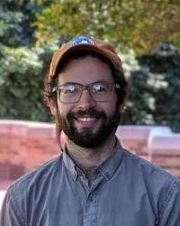
Geologists Dr. Joel Gombiner and Mark Amara will lead an exploration into the most enigmatic of the major coulees in the area of the Ice Age Floods.
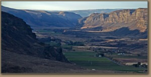
Questions and theories have arisen for years about how Moses Coulee was formed. It’s long been assumed it was cut by huge floods in the same way the other major coulees are thought to have been formed. But for much of the series of Missoula Floods the Moses Coulee area was blocked by the Okanogan Lobe of the Cordilleran Ice Sheet. Bretz postulated there were two major episodes of coulee formation, the first much older one occurring before the last, late Pleistocene major ice advance. Other theories postulate that it was cut by break-out floods coming from beneath the ice sheet that could have occurred during the latest major ice advance.

We’ll investigate 5 stops on this journey of Ice Age Floods geologic features starting from Jameson Lake near the head end of Moses Coulee and moving south down into central Moses Coulee. This field trip explores the glacial and flood features in Moses Coulee and involves short hikes at nearly
every stop.
Date: SUNDAY MAY 3, 2026
Start time: 10:00 am
Meeting Place / Driving Directions: Meet at the Jameson Lake WDFW Boat Launch and Rest Area at 441 South Jameson Lake Road, Waterville, WA 98858 at this map link: https://maps.app.goo.gl/kJdwZefZArVUpHQXA
Bring: lunch, drinks, snacks, appropriate clothing and footwear, camera, etc.
Bathrooms are available at the first stop only.

There is NO cost for the trip though Registration and a Discover Pass are required.
Due to limited car parking at several sites registration is limited to 30 people
Contact Vicki Rivers to register in advance by one of the following methods:
Text: 509.781.1701 or email: suezb@hotmail.com