
Tualatin Public Library

Tualatin Public Library Ice Age Floods National Geologic Trail The Tualatin Public Library, located just off Interstate 5 in Tualatin, Oregon, is home to a display of Ice Age Megafauna. The Library features a striking display of an articulated partial mastodon skeleton, which was discovered in Tualatin less than a mile away. In partnership with the Tualatin Historical Society, the Library also has a display of Ice Age fossils including the sacrum of a giant ground sloth, mammoth bones, and bones from other animals; small erratics; and replicas of an ancient bison skull, mastodon tooth, and mastodon tusk. Located adjacent to the Library is Tualatin River Greenway Trail, which features a geologic timeline incorporating the Ice Age Floods, plus erratics, fossil replicas, and interpretive signage. A unique highlight of the Tualatin Public Library is its striking display of an articulated mastodon skeleton, which is mounted in front of an etched-glass image of a mastodon. The mastodon skeleton was unearthed in Tualatin near the Library in 1962 by two Portland State University students. John George grew up in Tualatin and remembered the town marshal telling about some enormous bones that he had seen in the swamp near Nyberg Creek (just south of the current Fred Meyer store parking lot). Along with Ron and George Sund, George spent a a month excavating the bones, recovering nearly half of a skeleton. The bones were originally displayed at Portland State University before being given to then Tualatin City Manager Yvonne Addington in the 1970s. After several years in storage (first in Tualatin, then at the Portland Zoo), the Tualatin Historical Society and community members raised funds to have the bones cleaned and restored, and the skeleton was put on display within the Library. The current display was created as part of the Library’s renovation and expansion in 2008. The skeleton was carbon-dated and determined to have died about 14,000 years ago. Scientists estimate this mastodon was a female who died in her 20s. Tualatin has been named as a partner on the Ice Age Floods National Geologic Trail. In partnership with the Tualatin Historical Society, the Library also currently displays several other Ice Age relics. An interactive display in the Children’s Room offers the Library’s young visitors a hands-on opportunity to learn more about these massive creatures that once roamed in Tualatin. Quick Facts Location:18878 SW Martinazzi Ave, Tualatin, Oregon 97062
Crown Point National Natural Landmark

Crown Point National Natural Landmark Ice Age Floods National Geologic Trail – Historic Columbia River Highway This spectacular viewpoint along the Historic Columbia River Highway 30 was the site of the 1916 dedication of a highway that was, for that time, an innovative European-style road that traced a winding path through the perilous Columbia River Gorge, linking Portland and The Dalles. Vista House opened in 1918 as a glamorous rest stop and observatory for those traveling the new highway. This “comfort station” was a rest stop like no other, featuring marble floors, stained glass windows — and, of course, a stunning view. In the words of The Oregonian, it was “the finishing achievement for the greatest highway in America.” Architect Edgar M. Lazarus designed the building to be functional, beautiful and commemorative; a memorial to the settlers who had traveled the final stretch of the Oregon Trail along the Columbia River. Stone panels inside are carved with the names of settler families. Listed on the National Register of Historic Places in 1974, the building fulfills Lazarus’s vision as a “temple to the natural beauty of the Gorge.” The octagonal building houses a museum, gift shop and interpretive display of historic and geologic points of interest in the Gorge. Additional information about the site’s history can be found at the National Park Service website in their Vista House brochure. The landmark is open daily, weather permitting. It closes when winds reach 50mph or more. The Columbia River Gorge at Crown Point passes from the steeper, more rugged terrain of the western slopes of the Cascade Range to the broad Willamette Valley that stretchs along the western edge of the High Cascades from Oregon into Washington. To the east the spectacular Crown Point section of the Columbia River Gorge was downcut through thick 16 million year old flood basalts by the much older Columbia River as the Cascade Range rose over the past 5 million years. About 16,000 years ago the ice-age Missoula Floods roared repeatedly through the Gorge up to 1000 feed deep, sweeping away millions of years of accumulated rock debris and even tearing out the underlying basalt bedrock to form the steep sided, box-shaped Gorge cross-section we marvel at today. The Crown Point promontory provides a strategic vantage point for observing the beautiful entrance to the wonders of the Columbia River Gorge. Crown Point also marks the beginning of the “Waterfall Corridor” that features eight waterfalls along the historic highway, including Multnomah Falls. This is an excellent place to envision how 500 cubic miles of water might have rushed through the Gorge during the great Missoula Floods an the end of the last ice age. Quick Facts Designation: National Natural Landmark Location: 40700 Crown Point Hwy, Corbett, OR 97019 MANAGED BY: Oregon State Parks IMPORTANT: Hours and weather closures are posted at vistahouse.com, or by calling 503-344-1368. Check Vista House’s weather station before you go. Parking areas are open 6 a.m. to 9 p.m. Please note: the Historic Highway has instituted a reservation system. To travel the Waterfall Corridor timed Use Permits are needed from May 24th through September 5th.
Multnomah Falls and Lodge

Multnomah Falls and Lodge Ice Age Floods National Geologic Trail, Lewis & Clark National Historic Trail Oregon’s tallest waterfall (620 ft.) is just 30 minutes east of Portland and 30 minutes west of Hood River. Offering scenic splendor and a gateway to the Gorge’s Waterfall Corridor, the waterfall is the most visited outdoor attraction in the Pacific Northwest due to its constant flow and proximity to the Historic Columbia River Highway. The falls are fed by rainwater and snow-melt, and its steady stream runs year-round, making it a four-seasons attraction. The highest volume comes in winter and spring, and the waterfall sometimes freezes partially at the height of winter. Located at the base of the waterfall, Multnomah Falls Lodge built in 1925 has excellent views and is home to a restaurant, gift shop, espresso bar and U.S. Forest Service interpretive center. The I-84 parking lot is the only way to access to the falls; parking or stopping is not allowed on the historic highway. It is recommended to visit at off-times, i.e. early morning or mid week. You can also take a guided tour or a shuttle. Visit our Ice Age Floods Institute Field Guides Page for more information on Multnomah Falls and other attractions! Quick Facts Location:Corbett, Oregon MANAGED BY:Multnomah Falls Lodge
Columbia Gorge Discovery Center & Museum

Columbia Gorge Discovery Center & Museum Ice Age Floods National Geologic Trail, Lewis & Clark National Historic Trail, Oregon National Historic Trail The Columbia Gorge Discovery Center & Museum is located on a 54-acre point of land adjacent to the Columbia River and is the interpretive center for the Columbia River Gorge National Scenic Area. This area includes one of the oldest continuously occupied places in North America (over 11,000 years) and parts of the Lewis and Clark and Oregon Trails. On the grounds are walking trails, a pond, scenic overlooks, and historic artifacts. The 48,200 square foot Discovery Center & Museum building contains interactive exhibits about the creation of the gorge; Ice Age animals, including a full-size Columbian mammoth; the Lewis & Clark Corps of Discovery; native peoples of the area; and a life-size exhibit featuring a wagon-raft braving the Columbia River’s current. This is an excellent stop for families with children. Allow several hours for your visit. Modest admission is charged. SITE INFORMATION:Safety Considerations More Site Information Oregon National Historic Trail Quick Facts Location:5000 Discovery Drive, The Dalles, Oregon Significance:Interpretive center for the Columbia River Gorge National Scenic Area MANAGED BY:Columbia Gorge Discovery Center Museum Inside the Columbia Gorge Discovery Center and Museum
Hat Rock State Park
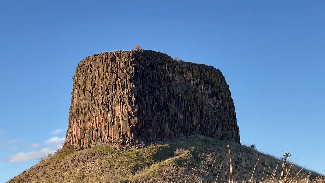
Hat Rock State Park Ice Age Floods National Geologic Trail, Lewis & Clark National Historic Trail Hat Rock is an erosion remnant warn way by floods from glaciers which melted over ten thousand years ago. Lewis and Clark saw this monument on their expedition and noted that it had a strong resemblance to a man’s hat. Imagine seeing this otherworldly boulder in the middle of a field of rolling hills in a vast, unexplored territory. The members of the expedition must have felt like they were on a different planet! While visiting Hat Rock today doesn’t have the same element of surprise, visitors will be able to enjoy a truly unique and beautiful landscape. The main attraction is of course, Hat Rock, and most people hike in the park to admire its natural beauty. Outside of Hat Rock, there are fields of scrub-land peppered with flowers as well as lush trees surrounding bodies of water. The park has its own pond, which is popular for fishing as it is teeming with rainbow trout. It also has access to a lake, a great place for water sports, and a sand volleyball court near the weather shelters. It is a perfect place for the whole family to experience the beauty of Oregon along the Columbia River. Quick Facts Location:Hermiston, OR MANAGED BY:Oregon State Park