Museum of Natural History, University of Oregon
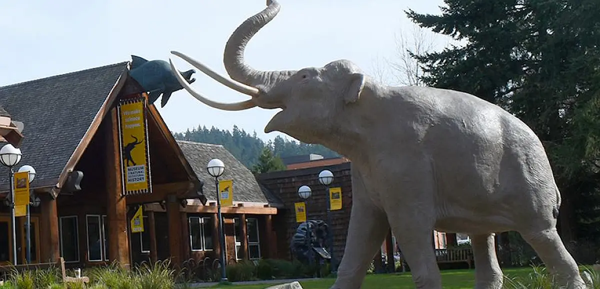
Museum of Natural and Cultural History, University of Oregon The museum offers a variety of seasonal and year-round programs for science and culture enthusiasts of every age. Delve into Oregon’s story, from the archaeology of the First Americans to the dynamic cultures of today’s Tribes. Experience the dynamic forces that shape Oregon’s landscapes, climate, and ecosystems. Meet giant salmon, Ice Age sloths, and other amazing animals from across the millennia. Museum initiatives steward Oregon’s past, present, and future. The museum is home to an invaluable record of Earth’s environments and cultures. As the state’s official repository for Oregon cultural and paleontological materials, our vaults house hundreds of thousands of objects ranging from archaeological and ethnographic items to fossils and geological specimens. The museum also curates extensive zoological and zooarchaeological collections used for comparison and identification of specimens from paleontological and cultural sites. Together, the collections inspire wonder, stewardship, and scholarship in Oregon and beyond. New discoveries constantly reshape our shared understanding of Earth’s natural and cultural histories. Explore the museum’s ongoing research in paleontology and archaeology, and learn how scholars from around the world are using our collections in their research. Website: https://mnch.uoregon.edu/ Hours: Wednesdays through Sundays 10:00 a.m. to 5:00 p.m., Thursdays until 8:00 p.m Entry Fees:•General: $6•Seniors (62+) & Youths (3-18): $12•Families (up to 2 adults and 4 youths): $12•Children (2 and under), UO students, LCC students, faculty, staff*, MNCH members: FreeVeterans and active-duty military*: Free Location:1680 East 15th AvenueEugene, OR 97403
Let Your Feet, and Your Imagination Roam at Rowena Crest and Tom McCall Preserve

Scenic Rowena Crest and the Tom McCall Preserve area provide an incredibly scenic place to let your feet, and your imagination wander as you look out on a major chokepoint along the Ice Age Floods path. The wildflower displays are amazing during the Spring, but several compelling flood-related features are visible from the vantage of the Rowena Crest Viewpoint any time of year. Rowena Crest lies nearly 700 feet above the Columbia River at the upstream end of the Rowena Plateau, a miles-long plateau that the river flows along. Just upriver from the plateau is the narrow section of the Gorge known as the Rowena Gap The drive to the viewpoint on old Hwy 30 from either east or west is a spectacular ride through a wonderous section of the Columbia River Gorge. A roundabout parking area at the viewpoint, with a safety wall above a sheer cliff, provides a great observation point eastward toward Rowena Gap. At Rowena Crest it’s easy to imagine what it might have been like to witness the approach of those massive floods. There is not yet scientific evidence that humans were in the area to bear witness to the Ice Age Floods, but there is solid evidence of humans in the Americas by that time. And there is growing concensus that if they came in during a glacial maximum, they would have come in by a coastal route that offered plentiful food and shelter for their journey. The mouth of the Columbia River would have been the first major waterway path inland that might have led them to settle in the area of the Floods. Your village might have been situated across the Columbia at the mouth of the Klickitat River where the town of Lyle now sits. If you were foraging, or just relaxing, atop Rowena Crest on a late summer day, you might have felt the ground begin to temble as if there were a small earthquake, but the trembling would have slowly increased for a few hours. Eventually you would have heard a low roaring sound that also grew over an hour or more before you could see turbulent brown muddy water begin flooding across the broad basin to the east. Then the roaring flood of water, only a few feet deep at first, would have entered the narrows, now called Rowena Gap, and sped on, crashing against the promontory you’re standing on and being diverted toward your village which was quickly washed away by the muddy torrent. But the muddy flood waters would have kept rising, unlike the Spring floods you’re used to on the Columbia, becoming a hundred feet deep, then two hundred as the levels just kept rising. Soon a huge whirlpool formed in the flood waters near the base of the promontory and a giant eddy formed where your village had been as flood waters flowed backward up the Klickitat River even as the bulk of the water continued downstream on the main stem of the Columbia. As the flood waters reached 400 and 500 feet deep and kept coming, suddenly to your right and left, huge blocks of the promontory broke off and slumped down into the rampaging flood waters. Now, even more fearful, you would have begun running south toward higher ground, climbing higher and higher as the still rising flood waters poured across the plateau and plunged into the small creek valley to the west, tearing away at the valley walls and massively widening that little valley. Eventually the flood waters stopped chasing you upward as you climbed higher, 200 then 300 feet above the now submerged promontory. Now, as you turned and looked out across that expanse of muddy water you could see massive white blocks of ice being carried along on the flood waters, similar but inconceivably larger than the ice blocks carried on the river during the Spring floods. But the flood waters didn’t begin to recede that day, nor the next, as they might in the Spring floods. In fact it was almost half a lunar cycle before they began to slowly recede, exposing a mud coated Columbia River valley that was now noticeably wider, with layers of shear vertical rock walls extending over 1000 feet above the normal river level below. As you began the recovery from the floods devastation, your family returned from from their hunting and gathering in the high mountain meadows, and you have an incredible story to pass along to them and your ancestors. This story is easy to imagine as you look out to the east from Rowena Crest. The onrushing Ice Age Floods waters easily flowed over the low relief of the broad Dalles Basin to the east, but the major Rowena Gap created a chokepoint in the path of the floods as they made their way through the Columbia River Gorge. This “hydraulic dam” forced the flood waters to build to over 1000 feet deep in this area, flowing hundreds of feet deep over Rowena Crest while forming a temporary lake in The Dalles basin. It is estimated that many of the 40-100 Ice Age Floods may have taken up to a month to completely flush through the system to the Pacific Ocean, but the duration of the flood waters at any point along the path probably lasted less than a couple of weeks. But this was more than enough to create several major floods features visible from this vantage point. At Columbia River level below and east of the promontory is a round Kolk pond that was created by giant whirlpools in the flood waters as they were deflected around the Rowena Crest promontory. Other similar Kolk features can also be seen on the Dallesport area to the east, and along the hiking path atop Rowena Crest where they are marked by surrounding groves of oak trees. Across the Columbia, the floods deposited a huge eddy gravel bar that the entire town of Lyle, Washington is built upon. The Klickitat River was backed
Oregon Museum of Science and Industry

Oregon Museum of Science and Industry Ice Age Floods National Geologic Trail The Oregon Museum of Science and Industry (OMSI) in Portland, Oregon, was founded in 1944. OMSI is one of the nation’s leading science museums and a trusted educational resource for communities throughout Oregon and the region. Through museum exhibitions, public programs at the museum and across the region, outdoor programs, traveling exhibitions, digital learning, and learning research and design, OMSI nourishes a lifelong love of science, curiosity and learning for diverse audiences. OMSI’s mission is to inspire curiosity through engaging science learning experiences, foster experimentation and the exchange of ideas, and stimulate informed action. OMSI’s vision is to collaborate with partners to ignite an education transformation at the intersection of science, technology, and design. We will weave a thriving innovation district into the fabric of Portland that spreads opportunities across the Northwest. Quick Facts Museum Hours as of Sept 6Tues-Sun 9:30-5:30 Visitor Informationhttps://omsi.edu/visitor-info
Tualatin Ice Age Walking Trail
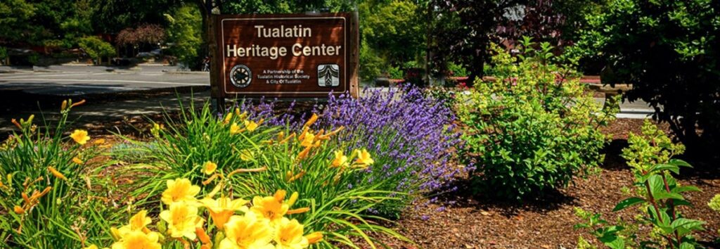
Tualatin Ice Age Walking Trail Ice Age Floods National Geologic Trail The Tualatin Ice Age Trail is a self-guided tour of sites representing the ancient history of our area. Along the trail, you’ll discover evidence of centuries-old ice, rock and bone, including the sites where a mastodon and ground sloth were unearthed. The trail also leads to a portion of the Tualatin ArtWalk, featuring sculptures, engravings and other Ice Age-inspired works of art. There are seven self-guided tours for the Tualatin Ice Age Trail, where you can read and learn more on interpretive signs, as well as on the Tualatin Trails website. The Raging Waters Tour takes you back to the Ice Age floods that carried erratic boulders here and shaped the Tualatin River with landslides and deposits. The water-themed artwork at Tualatin Lake of the Commons is also a nod to that history. Before and After Pictures of the Tualatin Heritage Center. Quick Facts Location:Tualatin Heritage Center8700 SW Sweek Dr. Tualatin, OR 97062
Columbia Gorge Discovery Center & Museum

Columbia Gorge Discovery Center & Museum Ice Age Floods National Geologic Trail, Lewis & Clark National Historic Trail, Oregon National Historic Trail The Columbia Gorge Discovery Center & Museum is located on a 54-acre point of land adjacent to the Columbia River and is the interpretive center for the Columbia River Gorge National Scenic Area. This area includes one of the oldest continuously occupied places in North America (over 11,000 years) and parts of the Lewis and Clark and Oregon Trails. On the grounds are walking trails, a pond, scenic overlooks, and historic artifacts. The 48,200 square foot Discovery Center & Museum building contains interactive exhibits about the creation of the gorge; Ice Age animals, including a full-size Columbian mammoth; the Lewis & Clark Corps of Discovery; native peoples of the area; and a life-size exhibit featuring a wagon-raft braving the Columbia River’s current. This is an excellent stop for families with children. Allow several hours for your visit. Modest admission is charged. Site Information Oregon National Historic Trail Quick Facts Location:5000 Discovery Drive, The Dalles, Oregon Significance:Interpretive center for the Columbia River Gorge National Scenic Area MANAGED BY:Columbia Gorge Discovery Center Museum Inside the Columbia Gorge Discovery Center and Museum
Willamette Floodplain National Natural Landmark
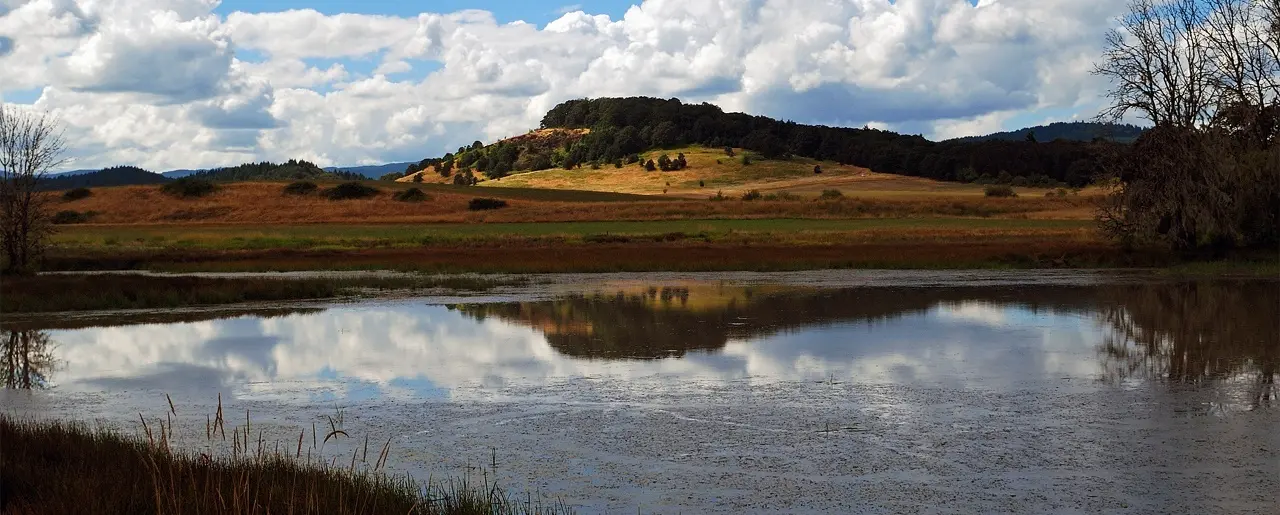
Willamette Floodplain National Natural Landmark Ice Age Floods National Geologic Trail The Willamette Floodplain represents the mix of bottom-land grasslands once common throughout the interior valleys of western Oregon and Washington. It is a large remnant example of largely un-plowed native grassland and ash woodland. The bottom-land grasslands include the largest remnants in the North Pacific Border Region. These grasslands include both the full range of bottom-land communities and the large diversity of endemic species primarily restricted to these habitats. The grassland communities include a fairly complex matrix of tufted hair grass bottom-land prairie (Deschampsia caespitosa valley prairie), sedge-meadow barley bottom-land grassland (Carex unilateralis – Hordeum branchyantherum bottomland grassland), and hawthorn- rose bottom-land shrub-land (Crataegus douglasii – Rosa nutkana bottomland shrub-land), all of which are well represented at the site in areas with pluvial clay or silty clay soils. In the better drained areas, where alluvial silt loams occur, a matrix of tufted hair grass valley prairie and red fescue valley prairie (Danthonia californica – Festuca rubra valley grassland) is found. In the very wet area along Muddy Creek are large and significant examples of Oregon ash bottom-land forests (Fraxinus latifolia/Carex obnupta and Fraxinus latifolia/Symphoricarpos albus). All of these grassland and shrub-land communities have become increasingly rare as most of the bottom-land areas in the interior valleys have been converted to farmland and to pasture. In the bottom-land grassland are found five vascular plant species listed by the U.S. Fish and Wildlife Service as candidate threatened or endangered species. The site also has populations of some threatened and endangered animal species. The area has occurrences of two threatened animals of concern to the U.S. Fish and Wildlife Service. Muddy Creek has populations of the Oregon Chub (Hybopsis crameri), a candidate species endemic to the Willamette and Umpqua River systems. The site has wintering populations of Lewis’ Woodpecker (Melanerpes lewis) and breeding Western Pond Turtles (Clemmys marmorata), both of which are considered threatened in Oregon but more common elsewhere. The site is located on essentially flat topography typical of the floor of the Willamette Valley. It is on the Calapooyia geomorphic surface, characterized by the absence of appreciable local relief. Elevation ranges from about 270 to 290 feet (82 to 88 meters). Gentle swales and ridges, which are most easily distinguished on aerial photographs, provide the only variation. Muddy Creek, a small, turbid, meandering, valley-bottom stream with associated ash forests, flows along the eastern edge of the area. Quick Facts Location:William L. Finley National Wildlife Refuge can be found off of Highway 99W 10 miles south of Corvallis, Oregon. You can also reach the Refuge via Bellfountain Rd. along the west of the Refuge.
Erratic Rock State Natural Site (Bellevue Erratic)

Erratic Rock State Natural Site (Bellevue Erratic) Ice Age Floods National Geologic Trail Six miles west of McMinnville just off of Hwy 18 sits a 90-ton rock, the Bellevue Erratic, that was floated as much as 500 miles in an iceberg by way of the Columbia River during the Ice Age Floods. The largest iceberg erratic found in the Willamette Valley, it’s originally from the Northern Rocky Mountains. When the iceberg in which it was encased melted, the rock was left behind at the 300 foot elevation level. A short uphill hike leads visitors to the Erratic Rock State Natural Site, where they can look out across the vast landscape and imagine the huge amount of water that filled the Willamette Valley during the Ice Age Floods. The Bellevue erratic rests upon a gentle hill 150 ft above the floor of Oregon’s bucolic Willamette Valley. The erratic floated in on an iceberg during a Missoula mega-flood when floodwaters backed up to 400 ft elevation behind the Kalama Gap choke-point, forming temporary Lake Allison. This is akin to Wallula Gap forming terminal Lake Lewis and Lake Condon on the southern/downstream side of the Gap, and the erratics found at ~1200ft asl there. The erratic Bellevue boulder consists of banded argillite, which can be traced back 400 miles or more to the 1.5 BILLION-year-old Belt Supergroup that lay beneath the ice dam for glacial Lake Missoula in northern Idaho! This is the source of pinkish Missoula flood sediments, as well. The discovery that erratic rocks were found at or below the 400 foot elevation in the Willamette Valley indicated that the water inundated this region from Portland down to Eugene up to 400 feet above present day sea level! The Portland region owes its rich agriculture, beautiful geography, and many handsome erratics to a series of massive Ice Age Floods that burst from an ice dam, the last of them about 15,000 years ago with a few smaller Glacial Lake Columbia mega-flood pulses finishing off around 14 kya. Quick Facts Location:Erratic Rock State Natural Site,McMinnville, OR 97128
Tualatin Public Library

Tualatin Public Library Ice Age Floods National Geologic Trail The Tualatin Public Library, located just off Interstate 5 in Tualatin, Oregon, is home to a display of Ice Age Megafauna. The Library features a striking display of an articulated partial mastodon skeleton, which was discovered in Tualatin less than a mile away. In partnership with the Tualatin Historical Society, the Library also has a display of Ice Age fossils including the sacrum of a giant ground sloth, mammoth bones, and bones from other animals; small erratics; and replicas of an ancient bison skull, mastodon tooth, and mastodon tusk. Located adjacent to the Library is Tualatin River Greenway Trail, which features a geologic timeline incorporating the Ice Age Floods, plus erratics, fossil replicas, and interpretive signage. A unique highlight of the Tualatin Public Library is its striking display of an articulated mastodon skeleton, which is mounted in front of an etched-glass image of a mastodon. The mastodon skeleton was unearthed in Tualatin near the Library in 1962 by two Portland State University students. John George grew up in Tualatin and remembered the town marshal telling about some enormous bones that he had seen in the swamp near Nyberg Creek (just south of the current Fred Meyer store parking lot). Along with Ron and George Sund, George spent a a month excavating the bones, recovering nearly half of a skeleton. The bones were originally displayed at Portland State University before being given to then Tualatin City Manager Yvonne Addington in the 1970s. After several years in storage (first in Tualatin, then at the Portland Zoo), the Tualatin Historical Society and community members raised funds to have the bones cleaned and restored, and the skeleton was put on display within the Library. The current display was created as part of the Library’s renovation and expansion in 2008. The skeleton was carbon-dated and determined to have died about 14,000 years ago. Scientists estimate this mastodon was a female who died in her 20s. Tualatin has been named as a partner on the Ice Age Floods National Geologic Trail. In partnership with the Tualatin Historical Society, the Library also currently displays several other Ice Age relics. An interactive display in the Children’s Room offers the Library’s young visitors a hands-on opportunity to learn more about these massive creatures that once roamed in Tualatin. Quick Facts Location:18878 SW Martinazzi Ave, Tualatin, Oregon 97062
Crown Point National Natural Landmark

Crown Point National Natural Landmark Ice Age Floods National Geologic Trail – Historic Columbia River Highway This spectacular viewpoint along the Historic Columbia River Highway 30 was the site of the 1916 dedication of a highway that was, for that time, an innovative European-style road that traced a winding path through the perilous Columbia River Gorge, linking Portland and The Dalles. Vista House opened in 1918 as a glamorous rest stop and observatory for those traveling the new highway. This “comfort station” was a rest stop like no other, featuring marble floors, stained glass windows — and, of course, a stunning view. In the words of The Oregonian, it was “the finishing achievement for the greatest highway in America.” Architect Edgar M. Lazarus designed the building to be functional, beautiful and commemorative; a memorial to the settlers who had traveled the final stretch of the Oregon Trail along the Columbia River. Stone panels inside are carved with the names of settler families. Listed on the National Register of Historic Places in 1974, the building fulfills Lazarus’s vision as a “temple to the natural beauty of the Gorge.” The octagonal building houses a museum, gift shop and interpretive display of historic and geologic points of interest in the Gorge. Additional information about the site’s history can be found at the National Park Service website in their Vista House brochure. The landmark is open daily, weather permitting. It closes when winds reach 50mph or more. The Columbia River Gorge at Crown Point passes from the steeper, more rugged terrain of the western slopes of the Cascade Range to the broad Willamette Valley that stretchs along the western edge of the High Cascades from Oregon into Washington. To the east the spectacular Crown Point section of the Columbia River Gorge was downcut through thick 16 million year old flood basalts by the much older Columbia River as the Cascade Range rose over the past 5 million years. About 16,000 years ago the ice-age Missoula Floods roared repeatedly through the Gorge up to 1000 feed deep, sweeping away millions of years of accumulated rock debris and even tearing out the underlying basalt bedrock to form the steep sided, box-shaped Gorge cross-section we marvel at today. The Crown Point promontory provides a strategic vantage point for observing the beautiful entrance to the wonders of the Columbia River Gorge. Crown Point also marks the beginning of the “Waterfall Corridor” that features eight waterfalls along the historic highway, including Multnomah Falls. This is an excellent place to envision how 500 cubic miles of water might have rushed through the Gorge during the great Missoula Floods an the end of the last ice age. Quick Facts Designation: National Natural Landmark Location: 40700 Crown Point Hwy, Corbett, OR 97019 MANAGED BY: Oregon State Parks IMPORTANT: Hours and weather closures are posted at vistahouse.com, or by calling 503-344-1368. Check Vista House’s weather station before you go. Parking areas are open 6 a.m. to 9 p.m. Please note: the Historic Highway has instituted a reservation system. To travel the Waterfall Corridor timed Use Permits are needed from May 24th through September 5th.
Multnomah Falls and Lodge

Multnomah Falls and Lodge Ice Age Floods National Geologic Trail, Lewis & Clark National Historic Trail Oregon’s tallest waterfall (620 ft.) is just 30 minutes east of Portland and 30 minutes west of Hood River. Offering scenic splendor and a gateway to the Gorge’s Waterfall Corridor, the waterfall is the most visited outdoor attraction in the Pacific Northwest due to its constant flow and proximity to the Historic Columbia River Highway. The falls are fed by rainwater and snow-melt, and its steady stream runs year-round, making it a four-seasons attraction. The highest volume comes in winter and spring, and the waterfall sometimes freezes partially at the height of winter. Located at the base of the waterfall, Multnomah Falls Lodge built in 1925 has excellent views and is home to a restaurant, gift shop, espresso bar and U.S. Forest Service interpretive center. The I-84 parking lot is the only way to access to the falls; parking or stopping is not allowed on the historic highway. It is recommended to visit at off-times, i.e. early morning or mid week. You can also take a guided tour or a shuttle. Visit our Ice Age Floods Institute Field Guides Page for more information on Multnomah Falls and other attractions! Quick Facts Location:Corbett, Oregon MANAGED BY:Multnomah Falls Lodge