An Old Timer (Jeff Silkwood) IAFI Story

In the early days, the IAFI and National Geologic Trail were mainly good intentions and lacking in ways to communicate how enormous and special this landscape was. Jim Shelden, then Regional Geologist for Region One of the US Forest Service in Montana and now president of the Missoula chapter of IAFI, realized a good map was necessary to galvanize action on the project and legitimize the new group Jim Shelden had just hired Jeff Silkwood in an open-ended position as a Stay in School Cartographer and Database person in 1995. Jeff had just returned from military service and was enrolled in classes at U Montana. Jeff was assigned to digitizing maps of the Beartooth Mountains and other mapping projects in the states of the Northern Rockies. But he was particularly interested in Glacial Lake Missoula and the Ice Age Floods. And he knew he had the computer skills to use existing data to put a map together. As the maps grew larger, more complex and included features like hill shaded relief and multi 1-degree by 1-degree tiles fitted together that no one else could do, it slowly dawned on Jim that this guy was really something. The only limitations were equipment – no Dept of Ag computer could handle it nor could any plotter manage the print task. In those early days this involved overcoming computer limitations on the size of files. Combining digital elevation models for multiple tiles and maps resulted in gigantic files for the times and processor’s abilities. Jeff wrote 2500 lines of code linking multiple computers, writing new code to handle the plotter problems to complete this project over about a two year time span, working on this while completing other jobs which had more firm deadlines. The basic data came from the USGS digital version of topographic maps supplemented with data from NASA satellite images. Google was working with some of the same data for use in its own maps, and there was some back and forth communication with them on how to solve similar mapping problems. Mapping issues that came up for this project included drawing a boundary for the west coast at a time when the ocean level was much lower – which had to be done by hand. And decisions about the extent of the lake and the extent of the continental ice sheet and glaciers – maximum levels and multiple contributors as to extent were used. Initial drafts were printed on a pen plotter, then the imagery was upgraded to an ink jet printer, which was subject to fading. The final map with photo images was turned into print plates by the Forest Service special Publications group in Washington. Approval for even printing the map was complicated. – it was (and still is) the only map ever printed by USFS which was more than a travel map and identified by author. An initial printing of 2000 copies was authorized – and sold out in 3 days. Another printing of 2500 was done. The USGS ordered a third printing they sold from their Denver and Spokane Libraries. It is no longer available, supplanted by on-line maps, and subsequent versions with different detail (such as highways) done by Eastern Washington University and others. A few copies of the original map still exist, and Jeff is still working on cartography for a private firm in Missoula. The importance of the original map to give IAFI credibility and as a tool to tell the story and sell the need for a special designation has never been officially recognized…until now. Thank you Jeff for your personal commitment to this project, and thank you Jim for your support in making it happen.
IAFI Store Prices Increase for Non-Members in January

Non-members of IAFI have been increasingly taking advantage of our trust-based Free Shipping for Members. So we’ll be increasing the IAFI Store prices by 10% for non-members beginning in January 2024, but Members will continue to get Free Shipping and a 10% discount off their Cart total. Rather than impose a Member Login requirement we’ll be sending out a coupon code that members can use for their 10% Off and Free Shipping. We’ll see how this works out and make adjustments as needed to keep Store prices low for our Members.
Let Your Feet, and Your Imagination Roam at Rowena Crest and Tom McCall Preserve

Scenic Rowena Crest and the Tom McCall Preserve area provide an incredibly scenic place to let your feet, and your imagination wander as you look out on a major chokepoint along the Ice Age Floods path. The wildflower displays are amazing during the Spring, but several compelling flood-related features are visible from the vantage of the Rowena Crest Viewpoint any time of year. Rowena Crest lies nearly 700 feet above the Columbia River at the upstream end of the Rowena Plateau, a miles-long plateau that the river flows along. Just upriver from the plateau is the narrow section of the Gorge known as the Rowena Gap The drive to the viewpoint on old Hwy 30 from either east or west is a spectacular ride through a wonderous section of the Columbia River Gorge. A roundabout parking area at the viewpoint, with a safety wall above a sheer cliff, provides a great observation point eastward toward Rowena Gap. At Rowena Crest it’s easy to imagine what it might have been like to witness the approach of those massive floods. There is not yet scientific evidence that humans were in the area to bear witness to the Ice Age Floods, but there is solid evidence of humans in the Americas by that time. And there is growing concensus that if they came in during a glacial maximum, they would have come in by a coastal route that offered plentiful food and shelter for their journey. The mouth of the Columbia River would have been the first major waterway path inland that might have led them to settle in the area of the Floods. Your village might have been situated across the Columbia at the mouth of the Klickitat River where the town of Lyle now sits. If you were foraging, or just relaxing, atop Rowena Crest on a late summer day, you might have felt the ground begin to temble as if there were a small earthquake, but the trembling would have slowly increased for a few hours. Eventually you would have heard a low roaring sound that also grew over an hour or more before you could see turbulent brown muddy water begin flooding across the broad basin to the east. Then the roaring flood of water, only a few feet deep at first, would have entered the narrows, now called Rowena Gap, and sped on, crashing against the promontory you’re standing on and being diverted toward your village which was quickly washed away by the muddy torrent. But the muddy flood waters would have kept rising, unlike the Spring floods you’re used to on the Columbia, becoming a hundred feet deep, then two hundred as the levels just kept rising. Soon a huge whirlpool formed in the flood waters near the base of the promontory and a giant eddy formed where your village had been as flood waters flowed backward up the Klickitat River even as the bulk of the water continued downstream on the main stem of the Columbia. As the flood waters reached 400 and 500 feet deep and kept coming, suddenly to your right and left, huge blocks of the promontory broke off and slumped down into the rampaging flood waters. Now, even more fearful, you would have begun running south toward higher ground, climbing higher and higher as the still rising flood waters poured across the plateau and plunged into the small creek valley to the west, tearing away at the valley walls and massively widening that little valley. Eventually the flood waters stopped chasing you upward as you climbed higher, 200 then 300 feet above the now submerged promontory. Now, as you turned and looked out across that expanse of muddy water you could see massive white blocks of ice being carried along on the flood waters, similar but inconceivably larger than the ice blocks carried on the river during the Spring floods. But the flood waters didn’t begin to recede that day, nor the next, as they might in the Spring floods. In fact it was almost half a lunar cycle before they began to slowly recede, exposing a mud coated Columbia River valley that was now noticeably wider, with layers of shear vertical rock walls extending over 1000 feet above the normal river level below. As you began the recovery from the floods devastation, your family returned from from their hunting and gathering in the high mountain meadows, and you have an incredible story to pass along to them and your ancestors. This story is easy to imagine as you look out to the east from Rowena Crest. The onrushing Ice Age Floods waters easily flowed over the low relief of the broad Dalles Basin to the east, but the major Rowena Gap created a chokepoint in the path of the floods as they made their way through the Columbia River Gorge. This “hydraulic dam” forced the flood waters to build to over 1000 feet deep in this area, flowing hundreds of feet deep over Rowena Crest while forming a temporary lake in The Dalles basin. It is estimated that many of the 40-100 Ice Age Floods may have taken up to a month to completely flush through the system to the Pacific Ocean, but the duration of the flood waters at any point along the path probably lasted less than a couple of weeks. But this was more than enough to create several major floods features visible from this vantage point. At Columbia River level below and east of the promontory is a round Kolk pond that was created by giant whirlpools in the flood waters as they were deflected around the Rowena Crest promontory. Other similar Kolk features can also be seen on the Dallesport area to the east, and along the hiking path atop Rowena Crest where they are marked by surrounding groves of oak trees. Across the Columbia, the floods deposited a huge eddy gravel bar that the entire town of Lyle, Washington is built upon. The Klickitat River was backed
CONSUELO LARRABEE – April 14, 1939 – June 21, 2023

Consuelo Larrabee, a beloved member of the Ice Age Floods Institute Board of Directors and the Cheney-Spokane Chapter Board passed away suddenly on June 21, 2023; she was 84 years of age. Consuelo’s life could be described as one who advocated passionately for animal rights, human rights and the arts. She worked closely with children for most of her life, inspiring the love of learning, the outdoors, music, and animals, to mention only a few. She very much enjoyed traveling the world, often with friends or to see friends, and her trips always included hiking, the arts, meeting people, and enjoying great food with friends. She very often credited her mother and grandmother who provided her with a safe, playful, creative, inspirational and literate childhood. Consuelo’s grandfather, Charles X Larrabee, was instrumental in 1915 with creating Larrabee State Park, established as the first state park in Washington. He and his wife Francis donated an extensive piece of land along Chuckanut Bay to create the park and continued to donate large parcels of land over the years to expand the park. Larrabee State Park was one of Consuelo’s favorite places to spend time throughout her life, hiking through the beautiful forests, and enjoying the rocky beach. Consuelo contributed to and changed the lives of so many humans and animals, making their worlds a more special place. She loved those around her deeply, always celebrating a birthday, wedding anniversary or important event and made sure all knew they held a special place in her heart. Consuelo was a member of the Ice Age Floods Institute Board of Directors for almost 20 years and also served on the Board of Directors for the Cheney-Spokane Chapter for the last seven years. Her involvement with the Ice Age Floods story was one of the great loves in her life. She carried brochures in her handbag and in her car, distributing them to individuals she met every place she travelled. She made sure they knew of how the Great Missoula Floods created the landscape we enjoy in the Northwest today. Along with several others involved with the Institute and the Cheney-Spokane Chapter, she worked diligently with this team over a couple of years writing Floods interpretive signs. These signs are located in the Ice Age Floods Playground at Riverfront Park located on the east bank of the Spokane River in downtown Spokane. These signs provide visitors of all ages the opportunity to learn about all that shaped our regions topography. Consuelo was born on April 14th, 1939,; to Edward Payne and Consuelo McMillan Larrabee in Spokane, Washington. She attended school at St. Paul’s School for girls in Walla Walla, Washington. She then received her Bachelor of Fine Arts degree from San Francisco Art Institute, as well as a Masters in Special Education from Teacher’s College at Columbia University. Following her father who had spent seven years studying at Oxford University, she too attended Oxford University, taking teaching courses…and playing softball! Consuelo served as a head teacher in a program for Chinese immigrant children in San Francisco. This was followed by being a classroom teacher for deaf children, some with multiple disabilities, in New York City, San Francisco and Spokane. In 1989, Consuelo moved to San Juan Island for sixteen years. She served as Head of the Program Committee for the local theatre, as well as being active in building an animal shelter and promoting awareness about Orca whale population. Consuelo lived in Seattle for nine years, where she dedicated her life to the Seattle Opera, (being chauffer to many soloists who became life friends), the Seattle Animal Shelter and Discovery Park. Upon moving to Spokane in 2016, Consuelo dedicated her time to being a volunteer with KPBS and serving on their Board of Directors. She loved the Spokane Symphony and always played classical music in her home. Consuelo truly contributed to change in our world, and she will be sorely missed by many! Remembrances of Consuelo Larrabee may be made to KPBS in Spokane, SpokAnimal or the Ice Age Floods Institute.
Tualatin: Crossroads of the Ice Age Floods
Tualatin, Oregon, lies in its own valley near the head of the Willamette Valley. In the time of the Ice Age floods, about 18,000 years ago, the area was a rich wetland. The gift those floods left behind was a hearty silt containing loess that was picked up from lands in Eastern Washington in the rush of the flood waters. The depositied loess supported abundant plant life that supported the megafauna animals that benefitted from this rich land, including Columbian Mammoths, Mastodons, Giant Sloths, Grey Wolves, the first Horses, Bison and others in the Pleistocene Age. In today’s world, fossil hunting for these extinct animals is a fruitful treasure hunt and celebrated in the Tualatin area. Tualatin has helped lead the way in displaying Ice Age fossils at various family friendly sites in the City: Tualatin Public Library: Enter, and the first thing you see is the Mastodon skeleton displayed high behind the checkout desk framed in an etched glass panel depicting the grassland and the Mastodon’s body. This fossil skeleton was discovered nearby during a site excavation for a large retail store. Further on into the Library are a group of lighted display cabinets for fossils arranged on shelves. The cabinets are arranged side by side in a gentle arc for easy family viewing. 18878 SW Martinazzi, Tualatin, 97062. Tualatin Greenway: To the right and behind the Library/City Building is the entrance to the Tualatin Greenway, a trail system along the Tualatin River. It is complete with signage concerning Ice Age Floods. The primary trail is a long winding concrete path with a blue meandering mosaic center strip representing Tualatin’s part of the National Ice Age Trail. It’s a favorite for joggers, cyclists and those who love to walk. Cabela’s Shopping Center: Return from the Greenway to the front of the shopping center building. See the full-size juvenile Mastodon sculpture being admired by a farm boy holding a spade with which to find a fossil skeleton. At his farm, a molar tooth is a barn doorstop. Read the story on the plaque. Brian Keith is the sculptor. Inside Cabela’s store, see the Cave at the back which shows Ice Age fossils displayed in context. Tualatin Heritage Center: Here, Columbian Mammoth and Mastodon tusks are featured among other Ice Age fossils. Of special interest are the large granite boulder erratics on display outside, all with explanatory plaques. 8700 SW Sweek Dr., Tualatin, Oregon 97062 In addition, the Lower Columbia Chapter of the Ice Age Floods Institute offers regular presentations about various Ice Age Floods topics by renowned experts, as well as newsletters and other events of interest. Visit the Ice Age Floods Institute website (IAFI.org) for much more information.
Were Humans Present in the Area During the Ice Age Floods?

During the last ice age, humans ventured into two vast and completely unknown continents: North and South America. For nearly a century, researchers thought they knew how this wild journey occurred: The first people to cross the Bering Land Bridge, a massive swath of land that connected Asia with North America when sea levels were lower, were the Clovis, who made the journey shortly before 13,000 years ago. According to the Clovis First theory, every Indigenous person in the Americas could be traced to this single, inland migration, said Loren Davis, a professor of anthropology at Oregon State University. But in recent decades, several discoveries have revealed that humans first reached the so-called New World thousands of years before we initially thought and probably didn’t get there by an inland route. So who were the first Americans, and how and when did they arrive? Genetic studies suggest that the first people to arrive in the Americas descend from an ancestral group of Ancient North Siberians and East Asians that mingled around 20,000 to 23,000 years ago and crossed the Bering Land Bridge sometime between then and 15,500 years ago. Geneticists studying the first Americans tend to paint a more consistent picture than archaeologists do, mainly because they’re using the same human remains and genetic datasets. Genetic analyses have found that Ancient North Siberians and a group of East Asians paired up around 20,000 to 23,000 years ago. Soon after, the population split into two genetically distinct groups: one that stayed in Siberia, and another, the basal American branch, which emerged around 20,000 to 21,000 years ago. Genetic data suggest the descendants of this basal American branch crossed the Bering Land Bridge and became the first Americans. But some archaeological sites hint that people may have reached the Americas far earlier than that. There are fossilized human footprints in White Sands National Park in New Mexico that may date to 21,000 to 23,000 years ago. That would mean humans arrived in North America during the Last Glacial Maximum (LGM), which occurred between about 26,500 to 19,000 years ago, when ice sheets covered much of what is now Alaska, Canada and the northern U.S. Other, more equivocal data suggest the first people arrived in the Western Hemisphere by 25,000 or even 31,500, years ago. If these dates can be confirmed, they would paint a much more complex picture of how and when humans reached the Americas. Almost all scientists agree, however, that this incredible journey was made possible by the emergence of Beringia — a now-submerged, 1,100-mile-wide (1,800 kilometers) landmass that connected what is now Alaska and the Russian Far East. During the last ice age, much of Earth’s water was frozen in ice sheets, causing ocean levels to fall. Beringia surfaced once waters in the North Pacific dropped roughly 164 feet (50 meters) below today’s levels; it was passable by foot between 30,000 and 12,000 years ago. From there, the archaeological picture gets muddier. The older version of the story originated in the 1920s and 1930s, when Western archaeologists discovered sharp-edged, leaf-shaped stone spear points near Clovis, New Mexico. The people who made them, now dubbed the Clovis people, lived in North America between 13,000 and 12,700 years ago, based on a 2020 analysis of bone, charcoal and plant remains found at Clovis sites. At the time, it was thought that the Clovis traveled across Beringia and then moved through an ice-free corridor, or “a gap between the continental ice sheets,” in what is now part of Alaska and Canada. However, new discoveries have turned back the clock on the first Americans’ arrival. In 1976, researchers learned about the site of Monte Verde II in southern Chile, which radiocarbon dating showed was about 14,550 years old. It took decades for archaeologists to accept the dating of Monte Verde, but soon, other sites also pushed back the date of humans’ arrival in the Americas. The Paisley Caves in Oregon contain human coprolites, or fossilized poop, dating to about 14,500 years ago. Page-Ladson, a pre-Clovis site in Florida with stone tools and mastodon bones, dates to about 14,550 years ago. And Cooper’s Ferry — a site that includes stone tools, animal bones and charcoal — dates to around 16,000 years ago. Then, in 2021, scientists announced much more ancient traces of human occupation: fossilized footprints in White Sands, New Mexico dating to between 21,000 and 23,000 years ago. Sites such as White Sands and Cooper’s Ferry have big implications for how the first people arrived in the Americas. It’s thought that the ice-free corridor through North America didn’t fully open until about 13,800 years ago. So if humans were in the Americas long before then, they likely traveled there along the Pacific coast. That coastal journey could have been made by foot, by watercraft, or both. But no fossil or archaeological evidence of this journey has been unearthed. Ideally, archaeologists would like to find more sites from all of these branches, especially any remains that could explain the genetics behind the people at White Sands between 23,000 and 21,000 years ago. Evidence of these long-lost people can be found in the remains of the animals they butchered, the charcoal they burned, the tools they crafted and the loved ones they buried. Local Indigenous Peoples’ stories strongly suggest humans were in the area during the Ice Age Floods, but tangible scientific evidence is sparse and yet to be found in the area. Eedited from a Live Science article by Laura Geggel
Present-Day Glacial Outburst Floods – WaPo Article
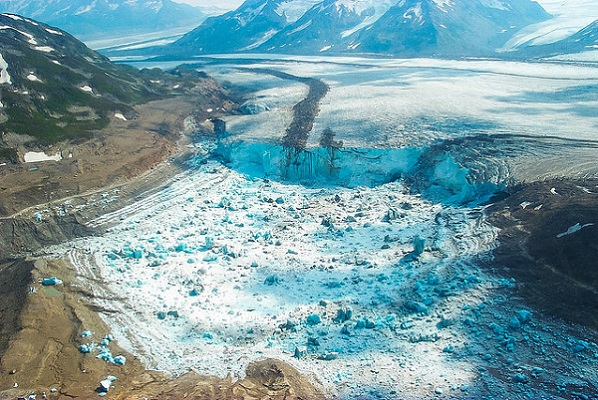
Mendenhall Glacier and other glaciers above Juneau, Alaska, while rapidly receding are trapping meltwaters that are more frequently being released as devastating ‘glacial outburst floods’ in mini-examples of the processes that produced the Ice Age Floods. The Washington Post recently produced a detailed article about the Aug. 5th flood that roared through Juneau on the order of a 500-year flood. Excerpted from Washington Post, Sept. 4th article by Joshua Partlow On the morning of Aug. 4 … “Looks like the basin is going.” The U.S. Geological Survey (USGS) gauge at Mendenhall Lake — at the foot of the glacier — was showing water levels rising sharply. … All summer, a jumble of icebergs and meltwater had been filling Suicide Basin. And when it eventually flushed out, as it had done more than 30 times since 2011, the water would pour into Mendenhall Lake and down the river to Juneau. … The glacier normally served as a dam for that reservoir of ice melt and rainwater, but when enough of it accumulated, the tremendous pressure could lift the glacier and let water escape underneath. This was known as going “subglacial.” When that happened … the passageway within the glacier can rapidly expand, emptying billions of gallons of water downstream in a matter of hours … About a week later,water began overtopping the ice dam and flowing down along the glacier’s flank. When this overtopping had happened in two previous years, the water found its subglacial escape hatch about a week later. But each year the glacier is changing, and the holes made the summer before may be gone. No one knew exactly when it might burst. On Aug. 4, with lake levels rising, the National Weather Service issued a warning predicting that Mendenhall Lake would peak the following evening around 10.7 feet — about five feet above its typical level … the next day … observing the raging river as water levels surpassed that initial projection and then kept going beyond the 12-foot record set in July 2016. Before the night was over, it would rise three feet higher.
Mima/Desert/Biscuit Mounds – An (Possible) Explanation

If you’ve visited the Rowena Crest Viewpoint at Tom McCall Preserve, west of The Dalles in the Columbia River Gorge, you may have noticed the many dome-shaped earthen mounds that cover the Rowena Plateau. These mounds are broadly circular and are surrounded by collections of basalt rock fragments. If you’ve visited the spring wildflower mecca of Catherine Creek on the Washington side of the Gorge, you may have also wondered at what caused the stripes of black rock extending down the slopes above the area. Tens of thousands of similar soil mounds cover large areas of the high desert lands of north-central Oregon, often in swarms that number in the hundreds. These mounds can be round or elongated, can range from a dozen feet to more than 60 feet in diameter atop the rocky Columbia River Basalt bedrock, and are typically surrounded and separated from each other by rings or stripes of basalt rock fragments. The mounds also appear similar to those at Mima Mounds Natural Area Preserve near Olympia, WA. There have been many suggested causes for the creation of these mounds, from burial mounds, to Pleistocene pocket gophers, to plants or glacial sun cups trapping wind-blown sediment, to sorting by earthquake vibrations, to turbulence at the base of ice-age floods flowing over the landscape. Research by two Oregon graduate students, Clark Nelson of Oregon State University and John Baine Pyrch of Portland State University, independently came up with what may be the most likely explanation for the origins of these enigmatic features. Their theses suggest desert mounds and their rock rings formed through a process of natural sorting, where fine soil material is pushed up into mounds and associated rocks are pushed out to the edges to form rings through countless cycles of wetting/drying and freeze/thaw during the wetter and colder period of the late Pleistocene. Clark Nelson cut a trench through a mound that exposed layers of soil and volcanic ash whose lack of mixing discounts the pocket gopher theory. Nelson also found that slope angle less than or greater than 10 degrees determined whether the features would form rounded mounds vs. elongated stripes. Pyrch showed the strips to be distinct from common talus slopes, because no obvious source of rock exists at the head of the talus stripe. He also observed that rocks within these stripes are sorted, unlike talus slopes, suggesting the same ice age freeze-thaw origins as soil mounds and rock rings. You can read more detailed articles about these enigmatic features in these articles: Mystery of the Desert Mounds Great Pyramids of the Gophers: Mima Mound Mystery Solved Similar processes are also thought to be responsible for the “patterned ground” found in periglacial environs. However these various types of features may have formed, we can be certain how the few mounds in the center of the parking circle at Rowena Crest Viewpoint came to be. They were man-made during the construction of the viewpoint and made to look like the mounds that cover the Rowena Plateau. At least one origin has a definitive answer.
Bone Pendants Suggest Humans in South America 25,000 Years Ago
The date that humans arrived in South America has been pushed back to at least 25,000 years ago, based on an unlikely source: bones from an extinct giant ground sloth that were crafted into pendants by ancient people. The presence of human-modified sloth bones in association with stone tools from geological layers that date to 25,000 to 27,000 years ago is strong evidence that people arrived in South America far earlier than previously assumed. Discovered in the Santa Elina rock shelter in central Brazil, three sloth osteoderms — bony deposits that form a kind of protective armor over the skin of animals such as armadillos — found near stone tools sported tiny holes that only humans could have made. The finding is among the earliest evidence for humans in the Americas, according to a paper published July 12 in the journal Proceedings of the Royal Society B. The Santa Elina rock shelter, located in the Mato Grosso state in central Brazil, has been studied by archaeologists since 1985. Previous research at the site noted the presence of more than 1,000 individual figures and signs drawn on the walls, hundreds of stone tool artifacts, and thousands of sloth osteoderms, with three of the osteoderms showing evidence of human-created drill holes. The newly published study documents these sloth osteoderms in exquisite detail to show that it is extremely unlikely that the holes in the bones were made naturally, with the implication that these bones push back the date humans settled in Brazil to 25,000 to 27,000 years ago. These dates are significant because of the growing — but still controversial — evidence for very early human occupation in South America, such as a date of 22,000 years ago for the Toca da Tira Peia rock shelter in eastern Brazil. Using a combination of microscopic and macroscopic visualization techniques, the team discovered that the osteoderms, and even their tiny holes, had been polished, and noted traces of stone tool incisions and scraping marks on the artifacts. Animal-made bite marks on all three osteoderms led them to exclude rodents as the creators of the holes. “These observations show that these three osteoderms were modified by humans into artefacts, probably personal ornaments,” the researchers wrote in their paper. Edited from Live Science article by Kristina Killgrove
Ice Age Floods National Geologic Trail – July 2023 Update
Hello from the trail. A lot has been happening over the past couple of months and I’ll start with our new National Park Service interactive web map (https://www.nps.gov/iafl/planyourvisit/maps.htm). Our new web map will help visitors locate and understand the complexity of various Ice Age flood features throughout Ice Age Floods National Georgic Trail. This new map would not have been possible without the support and collaboration of the Ice Age Floods Institute. The National Park Service has also been out and about with its mobile visitor center for the floods and Lake Roosevelt National Recreational Area. The trailer was at several Spokane conventions earlier this year and made an appearance at the 2023 Sand Hill Crane Festival is Othello, WA. This year’s Ice Age Floods Institute annual member meeting was a smashing success. The Jubilee was a grand time for many to dig deeper into their experiences with this fascinating story. So many floods’ detectives out walking, hiking, and driving Ice Age Floods National Geologic Trail, I was excited to meet and join with members through presentations, walks and tours in the heart of the Missoula Floods there at Dry Falls and the Grand Coulee. Last month the National Park Service was also fortunate enough to participate in the Geologic Society of America 2023 Penrose Conference. This conference focused on Glacial Lake Outburst Floods (GLOFs) and drew presentations from world renowned scientists. Fitting that this conference was also held at Dry Falls on the 100th anniversary of J Harlen Bretz’s first publication about the Channeled Scabland. It was great to see so many people thinking about outburst floods and, of course, several of the presentations focused on the Missoula Floods. Scientists from all over the world are taking various approaches to better understanding the forces at work during massive GOLF events. Efforts like dating giant gravel bars help us better understand when events took place, modeling water flow helps us see where water went based on various terrains, and new Light Detection and Ranging (LiDAR) data is helping us see past vegetation to the hidden landscape below. I was most impressed with the scope of efforts underway. From British Columbia, Alaska, and the Tropical Andes, to China, Antarctica, and Iceland, evidence of events like our Missoula Floods are being closely studied across the globe. Also in attendance were members of the twelve Bands which compose the Confederated Tribes of the Colville Reservation. The Grand Coulee and surrounding flood channels are the historic homelands of the Colville Tribe, and they shared cultural connections with the landscape and floods. In all some 70 participants helped create an atmosphere of reverence for a greater understanding of the forces at work changing our planet: then and now. I would also like to thank our partners at Washington State Parks for not only hosting both events but also for the daily care and respect they show these special places. Don’t forget you are also encouraged to come by the Dry Fall Visitor Center for this year’s Flood Fest, July 22, 11-3pm. See you there!