There are 4 Pieces in Our “Big One” Puzzle

The ground beneath our feet could be more complex than we thought! The Cascadia subduction zone, a giant underwater fault line stretching from California to Vancouver Island, has the potential to unleash massive earthquakes along the Pacific Northwest. New research reveals this megafault isn’t one smooth piece, but rather several sections that could rupture independently. This means a future earthquake might impact different areas in very different ways. “For places like Seattle and Tacoma,” says study co-author Harold Tobin, a UW geophysicist, “it could be the difference between a scary jolt and a total disaster.” Unlike some subduction zones with frequent smaller quakes, Cascadia stays quiet, making it tough to study. But scientists recently gathered new seismic data along a 560-mile stretch of the fault. This data shows the incoming ocean floor isn’t just diving under our continent, it’s also subdivided into four main zones. One zone, stretching from southern Washington to Vancouver Island, is particularly interesting. Here, the plates meet at a shallow angle, creating a large area of contact. Bigger area of contact means bigger potential earthquake, according to the study’s lead author, Suzanne Carbotte. The last major Cascadia quake hit in 1700, a monster estimated at magnitude 8.7 to 9.2. We don’t know if that quake ruptured the entire fault or just one section. This new understanding of the fault’s structure will help scientists predict future hazards, including ground shaking in places like Seattle and Vancouver, as well as tsunami risks along the coast. The bottom line? This segmentation means scientists can make better predictions about how strong shaking might be in different areas during a future earthquake. Read more in this Live Science article. Or you might want to watch this PBS YouTube video about ‘The Big One’.
Explore Historical Ice Age Floods Field Research with Google Maps and Google Earth
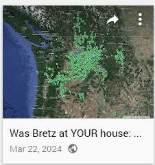
Explore Historical Field Research with Google Maps Did J harlan Bretz (and Others) Do Field Work near You? Ice Age Floods Institute is now a repository for interactive Google Maps that show the travels and field locations/notes of J Harlan Bretz and other field researchers that led to, and continue to refine, Bretz’s of theories of massive floods having created the unique Ice Age Floods landscapes of the Pacific NW. These detailed Google MyMaps (geospatial database files), created by Glenn Cruickshank, are valuable contributions to the Ice Age Floods story in the PacNW. They enable users to locate individual field sites and associated field notes, and to intimately delve into the research, observations and speculations of adherents and detractors of the Ice Age Floods. These interactive maps can be used to zoom in and explore hundreds of Bretz’s and others field locations and notes throughout the area. Links below to a number of other similar maps can help you open a dizzying realm of opportunities to more deeply explore the elements and thoughts behind the discoveries and historic research into the Ice Age Floods. Use your scroll wheel to zoom the map, click a marker for detailed information about a field site. These maps are part of a Google Earth project created by Glenn Cruickshank, supported by Nick Zentner and by the Ice Age Floods Institute through the efforts of webmasters Lloyd DeKay and Chris Sheeran. Glenn Cruickshank has approved the hosting of his MyMaps and Google Earth KML/KMZ files on the IAFI.org website. Glenn is a member of the “IAF Historical Locations on Google Earth” Working Group. The Google Earth KML/KMZ data files and copies of Bretz’s field notes can also be downloaded free of charge and without restriction at NickZentner.com. More Maps Even More Maps J Harlan Bretz – His Personal Memories Glenn Cruickshank recently met with Dean Kiefer. who shared a copy of J Harlan Bretz’s 4-volume memoirs in scanned .pdf format. Glenn converted them to text that also made them searchable. They are a very interesting read, though a bit stream-of-Bretz-consciousness in some sections. Still historically interesting, and a good add to our repository. Click the links below and enjoy! J Harlan Bretz Memories – Part 1 – 1972J Harlan Bretz Memories – Part 2J Harlan Bretz Memories – Part 3J Harlan Bretz Memories – Part 4 – 1975 create a personal tour Map in google earth How to load the Google Earth Geospatial Database Files into Google Earth You can create your own personal Google Earth map to view and use to explore selected field sites from the KMZ files for various researchers. First, download the KMZ files (listed on the right) into your local computer. Or download files from Nick Zentner’s website where they are named “GOOGLE EARTH Bretz Field Sites (yyyy)”. There will be one (or two) field notes for each corresponding KMZ, named FIELD NOTES or FIELD BOOK. Glenn suggests also downloading the field notes as .PDF’s for easier reading. The most complete directions for downloading KML/KMZ files are on the Google Help website Older version of Google Earth on Android:1. On your Android phone or tablet, open the Google Earth app2. Tap Menu Projects3. At the top, tap Open …4. Tap the file you want to add.5. To return to the map and open the file, tap Back New version of Google Earth for Chrome:On chrome go to https://www.google.com/earth/1. Click Launch Earth in Chrome2. Click the Menu button on the left side navigation bar3. Click Settings. Scroll to the bottom of the settings and where it says Enable KML File Import turn it on then click save4. Click New Google Earth Pro on the desktop:1. Launch the Google Earth Pro application2. Select File Open3. GE will place each file in the “Temporary Places” area on the left hand side of the frame. Makesure to move them ABOVE the Temporary Folder into the My Places folder (click and drag) before you exit GE, or else you will have to reload them every time.4. Repeat the process for each Bretz KML file you want to load. Click Here to download a printable PDF of these instructions download KMZ files
National Park Service Volunteer Gigs
National Volunteer Week is an annual celebration established in the U.S. in 1974. The National Park Service marked the occasion by recognizing those who already choose to spend their time volunteering in parks and urging others to consider doing so. Join Volunteers-In-Parks (VIP) to support the National Park Service in its mission to preserve and protect our national parks. You can volunteer for a day or year-round; on your own or with friends and family; close to home or at a dream destination. Volunteer opportunities are available nationwide including in U.S. Territories. What Can Volunteers Do? The possibilities are as diverse as the national parks themselves. Here are some example volunteer activities: Lead or support education and public-facing programs Maintain or rebuild trails or historic buildings Conduct research or monitor wildlife to preserve our natural resources Help families make memories happen as a campground host Teach others about the park and swear in new Junior Rangers in the visitor center Support libraries, archives, and museums in parks to preserve our cultural resources Produce art while staying in a park as an Artist-In-Residence Educate train travelers on the natural and cultural heritage of a region through the Trails & Rails program You can check out some of the National Park Service’s volunteering opportunities here. Alternatively, if the prospect of making the country a greener and cleaner place sounds like an intriguing full-time gig for you, learn how you can apply to be one of the inaugural members of the newly formed American Climate Corps.
Scabland – The Movie, A Google Earth Odyssey

“Scabland” – the Movie, A Google Earth Odyssey “Scabland” is a media complement to CWU Professor Nick Zentner’s 2023-2024 A-Z YouTube geology series that re-treads the ice age floods and the work of Professor J Harlen Bretz and others. In this short animation, viewers virtually fly to a selection of locations visited by geologist Dr J Harlen Bretz, with quotes from his original field notes, geolocated in Google Earth and animated with Google Earth Studio. To see more of these locations, visit https://www.geology.cwu.edu/facstaff/nick/gBRETZ/ This video was done as an experiment/prototype by the authors, Glenn Cruickshank and Eric Larson, to showcase Google Earth, virtual special effects techniques, some of the spectacular landforms caused by the floods, the impacts of ice and water during the Last Glacial Maximum and the field locations of J Harlen Bretz. Eric Larson in Billings MT runs Shashin Studio, a VFX video production company (contact@shashin.studio). Google Earth Glenn is a retired photojournalist and consultant in Liberty Lake WA. Credits: Glenn Cruickshank Eric Larson Two Steps From Hell Made with Google Earth and Google Earth Studio. Thanks to The Families of J Harlen Bretz and Thomas Large, Nick Zentner, Glenn Cruickshank, Bruce Bjornstad, The Ice Age Floods Institute, and many others.
Dan Foster and the Ice Age Floods story
In my “Tales from the Trail” I usually highlight a place important to our story. This time, I would like to highlight someone important to our story. On December 31st of 2023, Dan Foster, long-time Superintendent of Lake Roosevelt National Recreation Area, and Ice Age Floods National Geologic Trail retired after over four decades of public service. While he worked on many efforts over the years with multiple state and federal natural resources programs, Dan’s time supporting Ice Age Floods National Geologic Trail is something we should all be grateful for. Since 1992, Dan has worked for the National Park Service in various resource management positions, including Superintendent at Niobrara National Scenic River. In 2013, he became the Superintendent of both Lake Roosevelt National Recreation Area and Ice Age Floods National Geologic Trail. In 2014, Dan’s leadership led to the development of the Trail’s Foundation Statement, which is still instrumental today in directing the focus and daily activities of the Trail. It solidified the notion of this public-private partnership we all call Ice Age Floods National Geologic Trail today. Working in collaboration with partners across four states, Dan also led the development of the 2016 Long Range Interpretive Plan and, the following year, the Trail’s first Junior Ranger book. Dan was instrumental in influencing the City of Tualatin to develop an Ice Age Floods theme for many city attractions, including city parks, hiking trails, the library, and local businesses. Dan’s commitment to securing additional resources for the Trail led directly to the National Park Service creating the Program Manager position which I am grateful to occupy today. For over a decade of his career, Dan led the Nation’s only National Geologic Trail. It’s not easy being the first, and Dan’s years of experience and leadership have given our Nation Trail a solid foundation to build upon. Dan still lives in Grand Coulee, Washington, right on the Trail in the middle of Grand Coulee, and you just might see him paddling away out there on Banks Lake. Dan, we are truly grateful for everything you have done for the Ice Age Floods National Geologic Trail! Article by Justin Radford, Program Manager – Ice Age Floods National Geologic Trail, Acting Park Manager – Lake Roosevelt National Recreation Area
Moses Coulee: Unveiling the Mystery of a Colossal Ice Age Scar
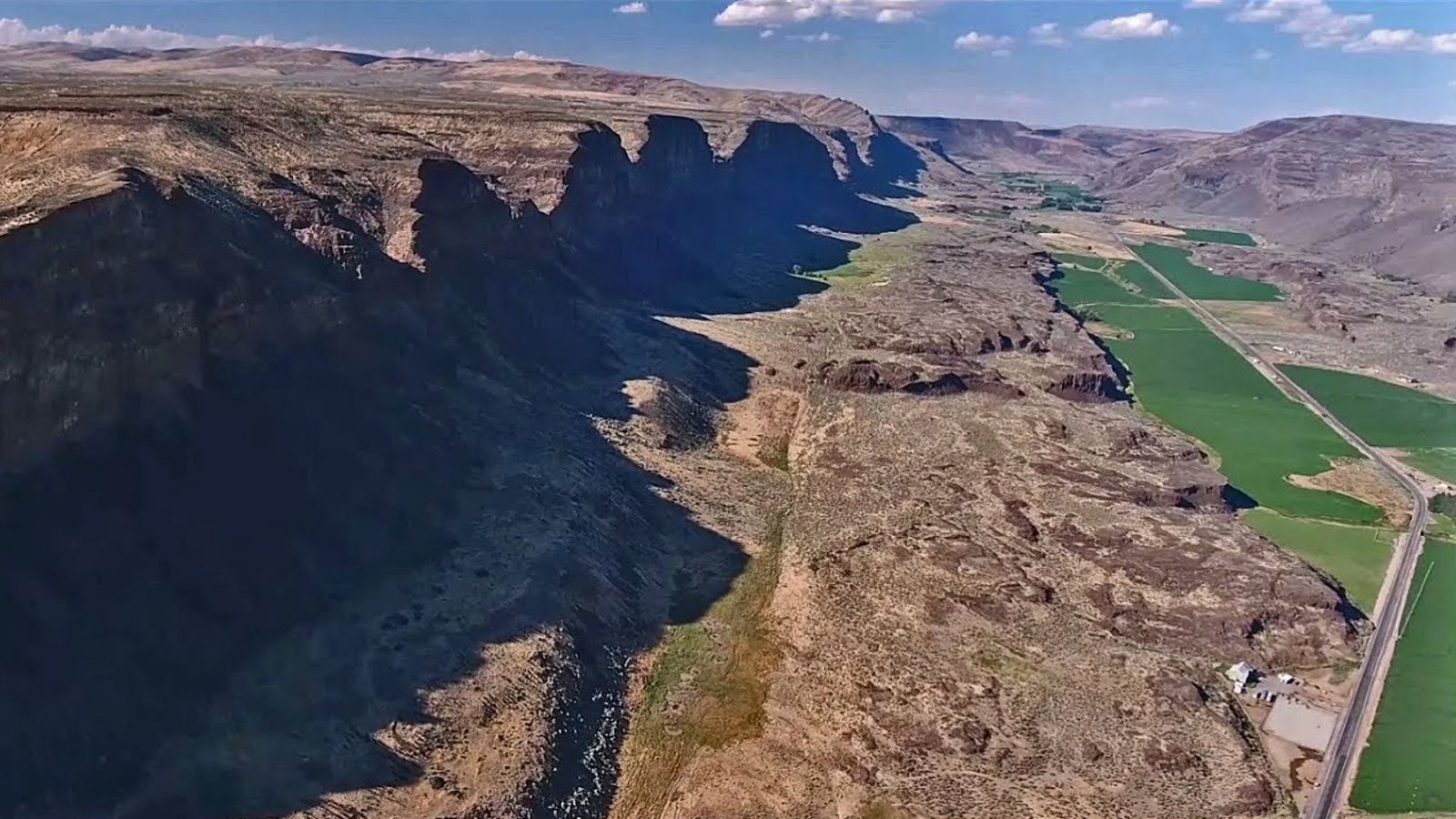
Moses Coulee, a Washington state wonder, has puzzled geologists for over a century. This massive canyon, carved into solid basalt, stands as a testament to some powerful force. The culprit? The Ice Age Floods, a series of catastrophic deluges that reshaped the landscape. If you’ve ever visited, or even just passed through Moses Coulee, you may not have been aware that this awe-inspiring coulee has been an Ice Age Floods conundrum since the time geologist J Harlen Bretz first noted it in 1922. The problem? Moses Coulee doesn’t quite fit the picture. As Bretz described it, “The head of Moses Coulee is just north of Grimes Lake. It is an abrupt termination, walled by 100 foot cliffs, identical with the features of channeled scabland which are called abandoned cataracts.” The head of the coulee ends abruptly, lacking any clear connection to the known flood paths. Theorists proposed a missing link, a path obliterated by the Okanagan Ice Lobe, but no evidence of such a grand passage has ever been found. The mystery has persisted and become more enigmatic as Ice Age Floods research has flourished over the years: what colossal force carved this immense coulee? A new study by Gombiner and Lesemann (Geology, 2024) offers a radical new hypothesis. They propose a surprising source for flood waters: meltwater trapped beneath the massive Okanagan Ice Lobe glacier. Imagine the giant Okanagan ice sheet pressing down on the Waterville Plateau. Meltwater pooled in valleys beneath the ice, trapped and pressurized. This water, according to the theory, found a surprising escape route. Flowing through a network of hidden channels, it carved its way across intervening ridges and valleys, eventually funneling into Moses Coulee. This “tunnel channel network,” as the researchers describe it, explains the unusual path of the water. The channels themselves, carved in basalt, climb slopes and defy normal drainage patterns. These features, along with glacial landforms like eskers, suggest a watery escape route beneath the ice sheet. The study doesn’t rule out the role of traditional Ice Age Floods. Water from massive glacial lakes might have also contributed to Moses Coulee’s formation by flowing along the eastern edge of the glacier. This new hypothesis could be a game-changer. It suggests a hidden world of pressurized meltwater sculpting the landscape beneath the ice. While the debate continues, one thing is certain: Moses Coulee remains a captivating enigma, a place where the power of water and ice continues to unfold its secrets.
First Grader Fascinated By Floods Story
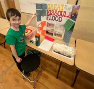
Max Vuletich, a first grader at Jefferson Elementary in Spokane, Washington, exhibited at a STEM Event in March 2024. He prepared a display and shared the Floods story to the many attendees that stopped by his table. He became interested in the Great Missoula Floods when he saw a Public Television video in Kindergarten. He went to a Library and began reading about The Floods and googling topics. His mother, Mariah, reported that he loves the Floods story and continues to be passionate about learning all he can. Perhaps he is destined to be a geologist!
Visit Wenatchee, Washington – Explore Ice Age Flood Features

Wenatchee, Washington is often called the “Apple Capital of the World” or the “Buckle of the Power Belt of the Pacific Northwest”. Today the Wenatchee vicinity is known for the fruit industry, wineries, power generation, tourism and outdoor recreation. When you visit and look around the Wenatchee Valley, even today, much of the landscape was formed by Ice Age Flooding. Visit the Wenatchee Valley area to explore some of the interesting Ice Age Flood features found there. Toward the end of the Pleistocene Ice Ages (17,000-12,000 years ago) much of the landscape in the Wenatchee area was changed substantially by catastrophic ice-age flooding. These flood(s), almost 1,000 feet deep, initiated out of glacial Lake Missoula in Montana, and some of the largest came through the Wenatchee area along the Columbia River drainage. Prior to the Okanogan Ice Lobe blocking the Columbia River valley north of Wenatchee, the early Missoula flood(s) could follow the present day path of the Columbia River around the “Big Bend” area of north-central Washington into the Wenatchee area and further south. Take a drive north of Wenatchee on highways US 97 or US 97A to see evidence of this flooding. As the Okanogan Ice Lobe advanced south it eventually blocked the Columbia River drainage north of Wenatchee. The water backed up by that Okanogan Lobe ice dam formed glacial Lake Columbia and forced subsequent ice-age floods to be funneled southward along the east edge of the ice lobe into Moses and Grand Coulees, and farther east through the Channeled Scablands of eastern Washington. When the Okanagan ice eventually retreated, one last flood from glacial Lake Columbia again followed the Columbia drainage through Wenatchee. Massive boulders (some 40 feet in diameter) and erratics (rocks foreign to the area) were transported at the base of the flood waters and embedded in huge icebergs floating on the floodwaters. They were deposited along the hillsides throughout the Wenatchee area as the floods waned and the icebergs became stuck and melted. Those erratics prompted our Ice Age Floods Institute chapter name “The Wenatchee Valley Erratics”. The two main erratic rock types in this area, granite and gneiss, are much different from the Eocene Chumstick Sandstone bedrock. The gneiss erratics transported a relatively short distance from outcrops just north of Wenatchee are often 10 feet in diameter. The nearest granite outcrops occur some 15 miles upstream in the Entiat area, so the granite erratics tend to be smaller, less than 3 feet in diameter. Some of the best locations to see these erratics are just south of the Old Wenatchee Bridge (first bridge over the Columbia River finished in 1908) along the Apple Capital Loop Trail near Patriot Plumbing & Heating, the Department of Social & Health Services and near the old train at Mission Street Park in south Wenatchee. An enormous crescent-pendant Pangborn Bar topped with huge current ripples was deposited in east Wenatchee where the Columbia River drainage takes a right (easterly) turn. The bar elevation is 500 feet above the Columbia River today. On the surface of Pangborn Bar are giant current ripples with crests up to twenty feet tall and ripples spaced some 300 feet apart. Travel up Grant Road, 4th Street in East Wenatchee and then out onto Batterman Road northwest of Rock Island to travel across the entire Pangborn Bar from west to east. The giant current ripples are best observed on 2nd or 4th Streets, where these roads go up and over the current ripples east of Nile Avenue in East Wenatchee, Washington. Just about a mile northeast of Pangborn Memorial Airport is a very significant archaeological site, the East Wenatchee Clovis Site (Richey Clovis Cache), discovered in 1987 and excavated until the site was closed and covered in 2004. This site lies on top of one of these current ripples. Pristine Clovis spear points as well as other archaeological specimens (about 11,000 years old) were discovered and some are now on display at the Wenatchee Valley Museum and Cultural Center in Wenatchee. Article from Brent Cunderla, April 2024
Rock Map of Scotland
An interesting geology tidbit featured today in Nice News: @Jefferies_ Harry Jefferies shared this photo of his grandfather on X, explaining that the 85-year-old has been working on his rock map of Scotland since 1992 and wanted it to go viral on social media. The post garnered over 100,000 likes and millions of views in just a few days, so we’d say he’s succeeded. “He collected rocks during amateur geology trips over 30 years. He says it had to be geologically correct and also aesthetically pleasing,” Jefferies wrote, adding that his grandpa is now “over the moon” by the internet’s response to his creation. Get a closer look at it. (Photo Credit: @Jefferies_/ X)
Sarah Nance – Geologic Data Artist

I’m an artist using scientific data as an artistic medium − here’s how I make meaning As an artist working across media, I’ve used everything from thread to my voice to poetically translate and express information. Recently, I’ve been working with another medium – geologic datasets. While scientists use data visualization to show the results of a dataset in interesting and informative ways, my goal as an artist is a little different. In the studio, I treat geologic data as another material, using it to guide my interactions with Mylar film, knitting patterns or opera. Data, in my work, functions expressively and abstractly. Two of my projects in particular, “points of rupture” and “tidal arias,” exemplify this way of working. In these pieces, my goal is to offer new ways for people to personally relate to the immense scale of geologic time. Points of rupture An early project in which I treated data as a medium was my letterpress print series “points of rupture.” In this series, I encoded data from cryoseismic, or ice quake, events to create knitting patterns. Working with ice quake data was a continuation of my research into what I call “archived landscapes.” These are places that have had multiple distinct geologic identities over time, like mountains that were once sea reefs. Because knit textiles are made up of many individual stitches, I can use them to encode discrete data points. In a knitting pattern, or chart, each kind of stitch is represented by a specific symbol. I used the open-source program Stitch Maps to write the patterns for this project, translating the peaks and valleys of seismographs into individual stitch symbols. Knitting charts typically display these symbols in a grid. Instead, Stitch Maps allows them to fall as they would when knitted, so the chart mimics the shape of the final textile. I was drawn to the expressive possibilities of this feature and how the software allowed me to experiment. I was able to write patterns that worked only in theory and not as physical, handmade structures. This gave me more freedom to design patterns that fully expressed the datasets without having to ensure their viability as textiles. Glaciers form incrementally as new snowfall compacts previous layers of snow, crystallizing them into ice. A knitted fabric similarly accumulates in layers, as rows of interlocking loops. Each structure appears stable but could easily be dissolved. Ice quakes occur in glaciers as a result of calving events or pooling meltwater. Like melting glaciers, knitting is always in danger of coming apart – but instead of melting, by snagging and unraveling into formlessness. These structural similarities between glaciers and knitting are reflected in the “points of rupture” prints, where disruptive ice quakes translate into unknittable patterns. The loop Repeated, interlocking loops are the base units that compose the structure of a knitted textile. The loop also forms the seed of an in-progress work I pursued during an artist residency with the NASA GEODES research group. I joined their research team in Flagstaff, Arizona, in August 2023. I assisted in gathering data from sites within the San Francisco volcanic field, while also conducting my own fieldwork: photography, drawing, note-taking and walking. One of my walks was a trek around a particularly prominent geologic loop – the rim of the S P cinder cone volcano. This is the second crater walk I’ve completed, the first being a tracing of the subsurface rim of the Decorah impact structure in Iowa. I see my paths through these landscapes as stand-ins for yarn. Over time, by taking walks that trace craters, or geologic loops, I will perform a textile. The performance of something as familiar as a textile offers me a new way to think about something that is much more difficult to comprehend – geologic time. Reprinted from a The Conversation article by Sarah Nance