Columbia Gorge Master Naturalists Explore the Ice Age Floods
Ice Age Floods and geology were significant parts of a recently completed Oregon Master Naturalist program for the Columbia Gorge. This region ranges through a tremendous variety of ecosystems, environments and ecologies within only a 50-mile radius. Major dammed rivers and free-flowing wild and scenic tributaries host a wide variety of indigenous to migratory fish stocks and river ecologies. Boreal rainforests transition to oak woodlands, high desert grasslands, and sub-alpine to alpine environments, all within that 50-mile radius. Woven through all these are compelling geologic, cultural, and historical elements. All those stories were interwoven through multiple field days spent exploring the ecosystems of the Columbia Gorge region and the factors that influence them. Geologic stories of the peaceful Columbia River Gorge range over 50+ million cataclysmic years of arc volcanism, massive flood basalts, massive ice age floods, river-damming lahars, catastrophic landslides and earthquakes. It’s amazing to witness people’s intense interest in geology, especially in their own ‘backyards’, and that’s especially true for these students as they become certified master naturalists. These folks have committed to many hours of online coursework, multiple days of field experiences, and to sharing the knowledge they’ve garnered in 40 hours/year of volunteer hours. On behalf of the Ice Age Floods Institute, I’m honored to be one of the group of ‘experts’ helping to feed the curiosity of these budding master naturalists, and in the process expand my own knowledge of this amazing region. Find out more about the Oregon Master Naturalist program at http://oregonmasternaturalist.org/. Lloyd DeKay – President, Columbia River Gorge Chapter
Grand Coulee Area Hikes Report

Gene Kiver and Bruce Bjornstad led two hikes in the Grand Coulee area. A group of ~30 hikers joined in a moderately difficult hike into the Castle Lake Basin, part of a 4-mile wide cataract complex that extends all the way to Dry Falls. The hike started out near Coulee City by following the Main Canal, which delivers all water from the Columbia Basin Irrigation Project into two siphons that cross Don Paul Draw at the head of Deep Lake. From here the water disappears before flowing two miles, underground, through a pair of tunnels to Trail Lake Coulee. The hike continued by crossing a berm of basalt boulders, dug out for the Main Canal, into the Castle Lake Basin. A descent to the floor of the basin was possible via two steel ladders that crossed the cataract above the Castle Lake plunge pool. From there hikers traversed out to a potholed bench to a spectacular view above Deep Lake Coulee. The next day ~20 hikers joined a ~3 mile roundtrip hike to Giant Cave Arch, near Barker Canyon, along the west side of Upper Grand Coulee. For anyone interested, both these hikes are featured in “On the Trail of the Ice Age Floods: The Northern Reaches” a geologic guidebook published by Bjornstad and Kiver in 2012.
Killer Floods – A New Nova Video on PBS

Discover how colossal floods transformed the ancient landscape. All over the world, scientists are discovering traces of ancient floods on a scale that dwarfs even the most severe flood disasters of recent times. What triggered these cataclysmic floods, and could they strike again? In the Channeled Scablands of Washington State, the level prairie gives way to bizarre, gargantuan rock formations: house-sized boulders seemingly dropped from the sky, a cliff carved by a waterfall twice the height of Niagara, and potholes large enough to swallow cars. Like forensic detectives at a crime scene, geologists study these strange features and reconstruct catastrophic Ice Age floods more powerful than all the world’s top ten rivers combined.
New “Roadside Geology” Now In IAFI Store
The IAFI Store has added the newest editions of the widely acclaimed and very popular Roadside Geology books for both Oregon and Washington. Author, photographer, and geologist Marli Miller has written completely new second editions of these books based on the most up-to-date geologic understanding. Spectacular photographs showcase the states’ splendors while also helping readers understand geologic processes at work. These 2nd edition Roadside Geology books are a must-have for every Pacific NW resident, student, and rockhound. When the first edition of Roadside Geology of Oregon was published in 1978, it was revolutionary—the first book in a series designed to educate, inspire, and wow non-geologists. Back then, the implications of plate tectonic theory were only beginning to shape geologic research and discussion. Geologists hadn’t yet learned that Oregon’s Klamath and Blue Mountains were pieces of far-traveled island arcs and ocean basins that had been piled against the growing North American continent. Steaming volcanoes, ghost forests, recent landslides, and towns heated with geothermal energy attest to Oregon’s still-prominent position at the edge of an active tectonic plate. Since the first edition of Roadside Geology of Washington appeared on shelves in 1984, several generations of geologists and non-geologists have studied the wild assortment of rocks in the Evergreen State, from 45-million- year-old sandstone exposed in sea cliffs at Cape Flattery to 1.4-billion- year-old sandstone near Spokane. In between are the rugged granitic and metamorphic peaks of the North Cascades, the volcanic flows of Mt. Rainier and the other active volcanoes of the Cascade magmatic arc, and the 2-mile- thick flood basalts of the Columbia Basin. With the help of this completely revised second edition by Pacific Northwest geologists, you can appreciate the many spectacular geologic features along more than forty of Washington’s highways.
The Road Not Taken
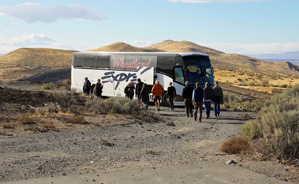
Robert Frost finished his poem “The Road Not Taken” with this verse: I shall be telling this with a sigh Somewhere ages and ages hence: Two roads diverged in a wood, and I— I took the one less traveled by, And that has made all the difference. As our President Gary Ford has stated before, one of the best things we do as chapters is bus tours. And what we get to do on our tours is take the road less traveled. On this year’s fall bus tour, our chapter took a loop around the asymmetrical anticline Saddle Mountains of the Yakima folds in central Washington. It began with a run on the Ice Age Floods Geologic Trail through the Drumheller Channels but much of the trip was on the road less traveled. This included a narrow gravel road that took us to the base of the Corfu landslide complex, the ghost town of Corfu and down a section of the diverted Ice Age Columbia River valley before we got back to the main highway to pass through Sentinel Gap for our lunch and tour at the Gingko Forest Winery. In the afternoon after passing around and on the Priest Rapid bar, viewing two more landslides on Umtanum Ridge, and a look at the historic “B” reactor on the Hanford Reservation, we once again took the wash boarded gravel road less traveled and climbed to the summit of the Saddle Mountains. This was the highlight of the trip for most of the forty adventurers as from there, we could look down upon most of the sights we had already traveled. On this tour, many of the “locals” were visiting areas in their backyard for the first time. Yes, traveling the road less taken makes all the difference. There are other great flood sites in our area that are on roads that tour buses can’t negotiate. Our chapter will soon be addressing this issue to see how we can take people on these roads. by Lloyd Stoess, President – Palouse Falls Chapter
DOGAMI Launches New LIDAR Data Viewer
The Oregon Department of Geology and Mineral Industries has launched the LIDAR Data Viewer interactive map, which offers additional data and new features that make exploring and downloading LIDAR easier than ever before. Visit the viewer: https://gis.dogami.oregon.gov/lidarviewer/ Since the Oregon LIDAR Consortium (OLC) was formed in 2007, DOGAMI has collaborated on collection of LIDAR data with more than 80 partners. The viewer offers OLC data for free download, and now includes data from 18 recent OLC projects. The newly available data includes: Lane County: 3,226 square miles. Covers portion of Douglas, Lane, Deschutes, Benton, Linn, Jefferson, Lincoln and Marion County. Consortium members include Lane County, City of Eugene and Springfield, Emerald People’s Utility District, Lane Council of Governments, Weyerhaeuser as well as Bureau of Land Management and the USGS. Metro: 1,240 square miles. The Metro project was a lidar and imagery collection that brought together over 30 different regional, local and state agencies that needed new elevation data covering the Portland Metro region. The project covers a small portion of Clatsop, Columbia, Hood River, Yamhill and Marion County as well as large portions of Washington, Multnomah and Clackamas County. Clackamol: 709 square miles. Covers portions of Clackamas and Marion County. The project was funded by USGS, National Resource Conservation Service (NRCS), Bureau of Land Management, Weyerhaeuser and Portland General Electric. Ochoco West: 474 square miles. Covers portion of Crook County. The data was supported by contributions from USDA Forest Service. And data from OLC projects: Green Peter, Big Windy 2013 and Big Windy 2015, Crooked Ochoco, Scappoose, Umatilla YST, Lower Malheur, Panther Creek 2015, Wasco, Four Rivers, Harney Basin, Wallowa 3DEP, Upper Rogue 3DEP, and Upper Umpqua 3DEP. For more information about the LIDAR Data Viewer or the Oregon LIDAR Consortium, contact: Jake Edwards Oregon Lidar Consortium Coordinator [sf_email]jacob.edwards@oregon.gov[/sf_email] 971-673-1557
The Columbia River Gorge Eagle Creek Fire – Ruin or Renewal?
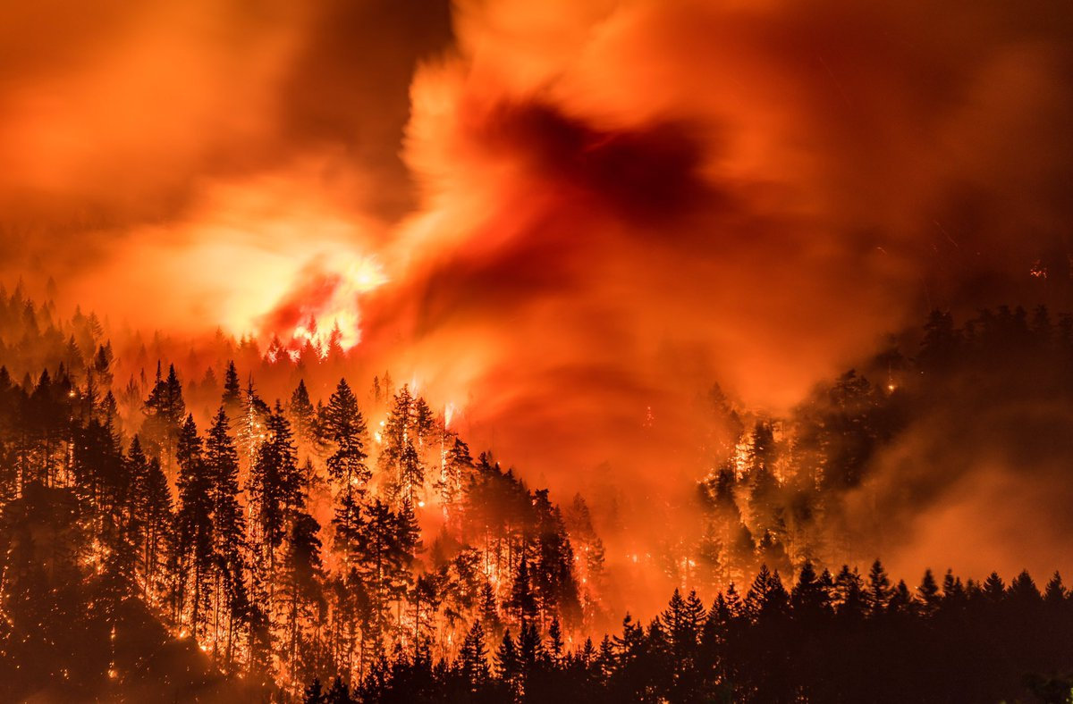
I’ve found there is huge public interest and concern about the catastrophic effects of the Eagle Creek Fire on the Columbia River Gorge. Pictures of ridgeline after ridgeline enveloped in bright orange fire, trees bursting into towering flames, and the choking smoke that filled valleys throughout the Pacific Northwest are truly a hellish image of Armageddon visited on the entire area. But, while the temporary loss of recreational trails and green forest aesthetics, and the increased potential for landslides and falling snags are inconvenient and even somewhat dangerous, the truth is that the recent fires have not ruined the natural areas of the West and the Gorge in particular, but instead have refreshed and renewed them. This past summer I’ve been interpreting geology for a new Columbia Gorge Master Naturalist Program, working beside forest ecology experts who are extremely optimistic regarding the effects of the Eagle Creek Fire. One of those experts, wildlife habitat expert Bill Weiler, writes, “Life will return to burned areas in short order. Fungi are already crawling around in the ashes of the fire, laying the foundation for soil that will support the plants that will constitute the early stage of the forest’s re-growth—a time when heat from the fire and sunlight newly reaching the ground in the absence of a canopy encourages a new crop of plants to firm up the soil structure that will allow gigantic trees to thrive. And ash is nature’s fertilizer. Plant blight, disease and insects are reduced or eliminated by burns. Mineral soil is the compost that Douglas fir seedling roots need to grow. “Dead trees” or snags are full of life.” In a typical forest fire a third of the trees will be scorched and dead, a third will be moderately to severely damaged, and a third will be essentially unscathed. Reports from the Eagle Creek Fire describe that fire as a discontinuous “mosaic burn” with much less devastation even than the typical forest fire burn. There is a broad consensus among scientists that we have considerably less fire of all intensities in our Western U.S. forests compared with natural, historical levels, when lightning-caused fires burned without humans trying to put them out. Early in the 20th century, before fire suppression became the norm, the average annual burn area in the western states was over 25 million acres, compared to a recent average of 4-6 million acres. According to Oregon State University Professor John Bailey, a century’s worth of suppressing wildfire in the United States has created conditions, especially in the West, that will ensure longer fire seasons because of longer, drier and hotter summers. Those conditions point to the need for “actively managed” forests which could include more deliberately set and managed prescribed fires. “Easily two-thirds or more of the Gorge fire is really good ecological fire,” Professor Bailey said, “the fire does some of the fuel management for us.” There is an equally strong consensus among scientists that fire is essential to maintain ecologically healthy forests and native biodiversity. This includes large fires and patches of intense fire, which create an abundance of biologically essential standing snags and naturally stimulate regeneration of vigorous new stands of forest. These areas of “snag forest habitat” are ecological treasures, not catastrophes, and many native wildlife species depend on this habitat to survive. More than 260 scientists wrote to Congress in 2015 noting that snag forests are “quite simply some of the best wildlife habitat in forests. ” Much of the Eagle Creek Fire burn area is closed to civilian activities due to the danger from flare-ups, rock slides and falling snags. The fire is less than 50% contained due to the ruggedness and inaccessibility of much of the area. Though it is still burning it is not expected to flare-up again until Winter rains and snow completely douse the embers.
New Ellensburg Chapter Webpage
The Ellensburg Chapter of the Ice Age Floods Institute has a new webpage with presentation videos and field trip guides. The Ellensburg Chapter was created in 2007 by Tom Foster, Karl Lillquist, & Nick Zentner. The chapter has offered free events for a solid decade and counting! Optional membership has supported the lectures and field trips. Thank you to our supporters! Our old field trip guides can now be viewed/downloaded from the webpage! Karl & Nick alternate leading 4 field trips per year. Note the contrasting styles of trip guides by Karl Lillquist (CWU Geography) and Nick Zentner (CWU Geology). Email Nick if you’d like to be added to the Ellensburg Chapter email list! nick@geology.cwu.edu [weaver_iframe src=’http://www.nickzentner.com/#/ellensburg-chapter-iafi/’ height=600 percent=100]
Ice Age Floods Story Map Wins ESRI Grand Prize!
The Washington Geological Survery (WGS) story map highlighting the ice-age floods that shaped the landscape of Montana, Idaho, Oregon, and Washington won the grand prize for scientific/technical story maps at the ESRI User Conference in San Diego last week. Woo-hoo! The Washington Ice Age Floods Story Map tells the story of cataclysmic outburst floods that shaped the landscape of the Pacific Northwest during the last ice age. With imagery, maps and video, this story map follows the devastating deluge of the Missoula floods as it tore across the landscape, from its origins in western Montana to its terminus at the Pacific Ocean. Our Award-Winning GIS Cartographer The mastermind behind this story map is WGS’s own very talented cartographer, Dan Coe. Dan also does all of the cartography for their geologic and hazard maps, maintains their website, and creates their interpretive lidar posters. On ESRI award day, Dan also won the second prize for his story map submission of “Native Trees of the Pacific Northwest“, which he created in his spare time. He’s quite the overachiever and they’re extremely lucky to have him with them. Reprinted from Washington State Geology News
Castle Lake Basin
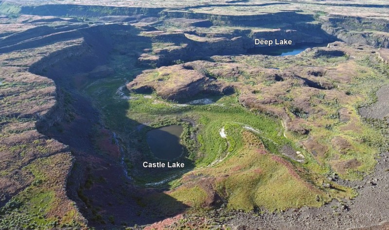
Castle Lake fills a plunge-pool at the base of a 300-ft tall cataract at the opposite (east) end of the Great Cataract Group from Dry Falls, above the east end of Deep Lake. A set of steel ladders put in place during the construction of the Columbia Basin Irrigation Project allow for a safe descent into the basin. In the basin are great views of giant potholes, the flood-sheared face of Castle Rock, as well idyllic Deep Lake. The Castle Lake Basin lies along the east end of the Great Cataract Group. At the base of the cataract is lovely blue-green Castle Lake plunge pool nestled into the rock bench below. Castle Lake lies within a single recessional cataract canyon eroded down to a flood-swept, pothole-studded rock bench that stands 100 feet above Deep Lake. This is the same rock bench of Grande Ronde Basalt where dozens of potholes occur at the opposite (western) end of Deep Lake. Castle Rock itself is an isolated butte along the west side of the Castle Lake basin. It is a faceted butte escarpment nearly sheared off by monstrous flood forces moving across the cataract.