Ice Age Floods National Geologic Trail – April 2023 Update
Spring is coming and the trail is starting to wake from its long winter break. Our National Park Service Interpretive Rangers are already out and about with our Mobile Visitor Center. Our team has made lots of contacts at various trade show events around Spokane, WA, and Washington State Parks joined NPS at the Othello Sandhill Crane Festival. Our thanks to Ranger’s Abby, Emilee and David for sharing the Missoula Floods story with over 500 visitors to the Scablands. From April 27th through May 25th the Mobile VC will be traveling to sites around Lake Roosevelt NRA on Thursdays. You can find the Ice Age Floods NGT and Lake Roosevelt NRA Mobile Visitor Center’s schedule and locations on our Ice Age Floods NGT calendar. Our Junior Ranger Program test is showing success and has already run out of booklets! Tualatin Library, one of the National Trail’s official partners, has been promoting and sharing our Junior Ranger activity booklet “Megaflood Adventure”. Young explorers can turn in completed booklets for Ice Age Floods NGT Junior Park Ranger badges. National Pak Service is exploring this program and hopes to bring more Junior Rangers into the Missoula Floods community. Out on the Trail: Now is a great time to explore the Willamette Valley searching for signs of great Missoula Floods and watching the valley spring to life. You might explore Erratic Rock State Natural Site near McMinnville, Oregon. There you will find ~90-ton chunk of Precambrian argillite sitting ~150 feet off the valley floor and some 500 miles from where this sort of rock originates. How did that happen? You can use the Trail’s NPS App to find out how and to explore more amazing landscapes changed by the Missoula Floods. Some of them are perhaps in your part of the world! I am looking forward to joining Institute members at the IAFI Rock-Out Jubilee in just a couple of months. I’ll see you there or out on Ice Age Floods National Geologic Trail this summer. Have fun and safe travels.
White Bluffs at Hanford Reach

Appearing much different than the nearly ubiquitous Columbia River basalt cliffs and boulders of central Washington, the White Bluffs area features a series of 50-170 m tall buff-colored bluffs and badlands underlain by those basalts. These are outcropping layers of the Ringold Formation comprising most of a 600-ft high escarpment exposed along the north and east banks of the Columbia River in south-central Washington. These ancient river and lakebed sediments were laid down by the Columbia and Snake River systems 8.5 to 3.4 million years ago. However, a section of the White Bluffs are a much younger stack of slackwater rhythmite deposits that filled a paleochannel eroded into the Ringold Formation, These late Ice Age rhythmites are only 17,550-12,500 years old. They were laid down as each of the 40 or more Ice Age Floods backed up behind the narrow constriction at Wallula Gap, submerging the entire White Bluffs area under temporary Lake Lewis. Up to about a dozen rhythmites, composed mostly of sand from as many floods, occur within the channel fill. At the top of most rhythmites is a layer of wind-blown sand suggesting a period of dryness separated each flood. Sediment thicknesses and sedimentary structures in each of the beds give a sense of the tremendous sediment load and the relatively calm conditions of the ponded flood waters. Learn more from Nick Zentner’s 2-Minute Geology video – The White Bluffs at Hanford Reach The White Bluffs are located along the east side of the Columbia River, across from the former towns of Hanford and Whitebluffs, on the Hanford Reach National Monument where the atomic age was born. The bluffs have been exposed by the Columbia River down cutting and moving laterally against the deep silts and sands and old soil horizons that make up the bluffs. These towering white bluffs, massive sand dunes, and the last free flowing nontidal section of the Columbia River all help make the Hanford Reach one of the most dramatic natural areas in the state. Take a Hike on the White Bluffs Rhythmites Trail, Lat, Long: 46.642855, -119.403263
Lake Lenore Caves – Lower Grand Coulee
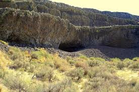
Tucked into the Lenore Canyon are the Lake Lenore Caves. Along with much of the eastern half of the state, Lenore Canyon was formed during the Missoula floods at the end of the last Ice Age, over 13,000 years ago. The glacial flood waters crashed down the canyon, carving through the basalt that makes up the sheer rock walls, creating coulees, ridges, cliffs, plateaus, rock slides, caves and a series of lakes. The caves themselves are shallow, created during the Great Missoula flood as water pulled chunks of basalt from the walls of the coulee. Post-flood weathering created talus slopes that furnished easy access and temporary overnight camps and storage for at least 5,000 years for hunters and gatherers from villages located elsewhere in the Grand Coulee and along the Columbia River and its tributaries. It is still used today for certain Native American religious ceremonies. It is easy to see why the caves were chosen as a cozy place to stay, as the depth provided plenty of shelter from the elements, while not going so deep that light couldn’t reach the back corners. It is often quite warm and breezy outside, but in the caves it is cool and calm. A well-marked 1.2-mile out-and-back trail leads from the parking area to some of the caves. It is generally considered an easy route that takes an average of 31 min to complete. This is a popular trail for hiking and walking, but you can still enjoy some solitude during quieter times of day. The best times to visit this trail are March through November. Dogs are welcome, but must be on a leash. The coulee walls in this area are made up of Grande Ronde Basalt flows overlain by the Frenchman Springs and Roza members of the Wanapum Basalt. The lower (colonnade) and upper (entablature) cooling units of individual flows are visible in the coulee walls. Flow unit contacts are sometimes complex to interpret. Some flows pinch out against older flows, some are perhaps due to flows covering an irregular topographic surface on the underlying flow, some may be filling of shallow valleys, and some multiple layers may be pulses of lava from the fluid interior pushing out over the partially formed entablature of a previous lava pulse.
How did humans first reach the Americas?

During the last ice age, which route was taken by the first humans to reach the Americas, and did they travel by foot, boat or both? Humans first arrived in North America at least 15,500 years ago. Exactly how they got there, however, constitutes one of the longest-standing debates in archaeology. For decades, scientists assumed that people first arrived in the Americas by walking south from the now-flooded land bridge in the Bering Strait that once connected Russia to Alaska when sea levels were lower during the last ice age. But recent evidence suggests that these people were not the first to set foot on the continent. According to the now-dominant “coastal route theory,” that distinction belongs to humans who boated down the Pacific coast several millennia earlier. A 2023 study(opens in new tab), for instance, found that coastal conditions were favorable during two time windows: from 24,500 to 22,000 years ago, and from 16,400 to 14,800 years ago. And while the science is far from settled, the evidence increasingly points to the first Americans arriving by sea or land along the coast. “The pendulum is swinging in support of the coastal corridor being the route taken by the first Americans,” Michael Waters(opens in new tab), director of the Center for the Study of the First Americans at Texas A&M University, told Live Science in an email. “But we still need the smoking gun: an early site along the coast.” Until 20 years ago, the best available archaeological evidence(opens in new tab) suggested that humans first arrived in North America about 13,000 years ago. The rise of the Clovis people — whose 13,400-year-old remains were discovered in Clovis, New Mexico, in the early 1900s — coincided perfectly with the formation of an ice-free corridor along the Rocky Mountains. Scientists assumed that these humans crossed the Bering Land Bridge into what is now Alaska, and then turned south to march onward to New Mexico through that convenient corridor. This remains the prevailing theory as to how the Clovis people made it to the Americas. “It seems very likely that people did arrive from northeast Asia via the ice free corridor once this route was open and viable,” Todd Braje, chair of anthropology at San Diego State University, told Live Science in an email. But recent excavations suggest that the Clovis were not the first Americans. A 2011 paper in the journal Science presented evidence of tools crafted by humans in Texas from up to 15,500 years ago, and a 2021 paper in Science described 23,000-year-old footprints in New Mexico. (However, the footprint date is disputed by a 2022 study in the journal Quaternary Research, which posits that the plant seeds the original team used to radiocarbon-date the footprint layer are problematic.) These “pre-Clovis people” would have had to migrate to America long before the ice-free corridor opened up. “The earliest the inland corridor was open is 14,300 years ago,” Waters said. “It is impossible to have people in Texas and Idaho at 16,000 years ago, and Florida at 14,600 years ago, come through the corridor. They must have come a different way.” How the pre-Clovis people got to America without an inland corridor to take them south from the Bering Strait remains an open question. “With the breaking of the Clovis barrier in the 1990s, we know people were in the Americas prior to at least 14,000 years ago, but when people first arrived and by what route or routes remains unknown,” Braje said. “There are now lively debates on the topic but the bottom line is that no one knows definitely.” The prevailing theory is that the pre-Clovis people arrived by watercraft. “The route taken by the initial migrants was almost certainly along the coast,” said Matthew Des Lauriers(opens in new tab), director of the Applied Archaeology Program at California State University, San Bernardino. Des Lauriers described the pre-Clovis as sophisticated maritime hunter-gatherers, who would have cast off south from the Bering Land Bridge and subsisted on fish and game as they voyaged down the Pacific coast. Ultimately, Des Lauriers said, these intrepid seafarers parted ways. Some pre-Clovis people followed rivers inland, while others continued south as far as Chile. “The ocean would always have provided resources for skilled fishermen and hunters,” Des Lauriers told Live Science in an email. “The most likely scenario is one of coastal fisher-hunter-gatherers moving along the North Pacific Coast.” Recent work from geologists has lent support to the theory that the Clovis people arrived via an inland corridor, while the pre-Clovis people took a coastal route. Beryllium-10 dating of glacial boulders(opens in new tab) along the ice-free corridor suggests that the corridor opened about 13,800 years ago. And studies suggest that a strip of unglaciated land should have existed along the Pacific coast of Alaska and British Columbia 16,000 years ago — prime real estate for a coastal corridor. As the field of ancient genetics has blossomed, multiple studies(opens in new tab) have provided additional evidence that the first Americans arrived between 15,000 and 17,000 years ago. “It is gratifying to see the archaeological and genetic evidence converging to tell the same story,” Waters said. “Finally, we have a much better understanding of the chronology of the opening of the two corridors, and the evidence now supports a coastal migration route.” Nonetheless, physical evidence for both corridors is still lacking. Significant archaeological, genetic and geologic legwork will be necessary before we can firmly point to the lives and times of the first Americans and begin to describe, with confidence, how they arrived in America. “There are very few sites along the Pacific Coast that are pre-Clovis in age, and much work needs to be accomplished to find potential early coastal sites,” Braje said. “We have no definitive answers about when and how people first arrived in the Americas.” Reproduced from an article by Joshua A. Krisch, published in Live Science More on archaeological research into early human migration into the Americas: The Fertile Shore
Ice Age Flood Pathways in the North-Central Washington Area
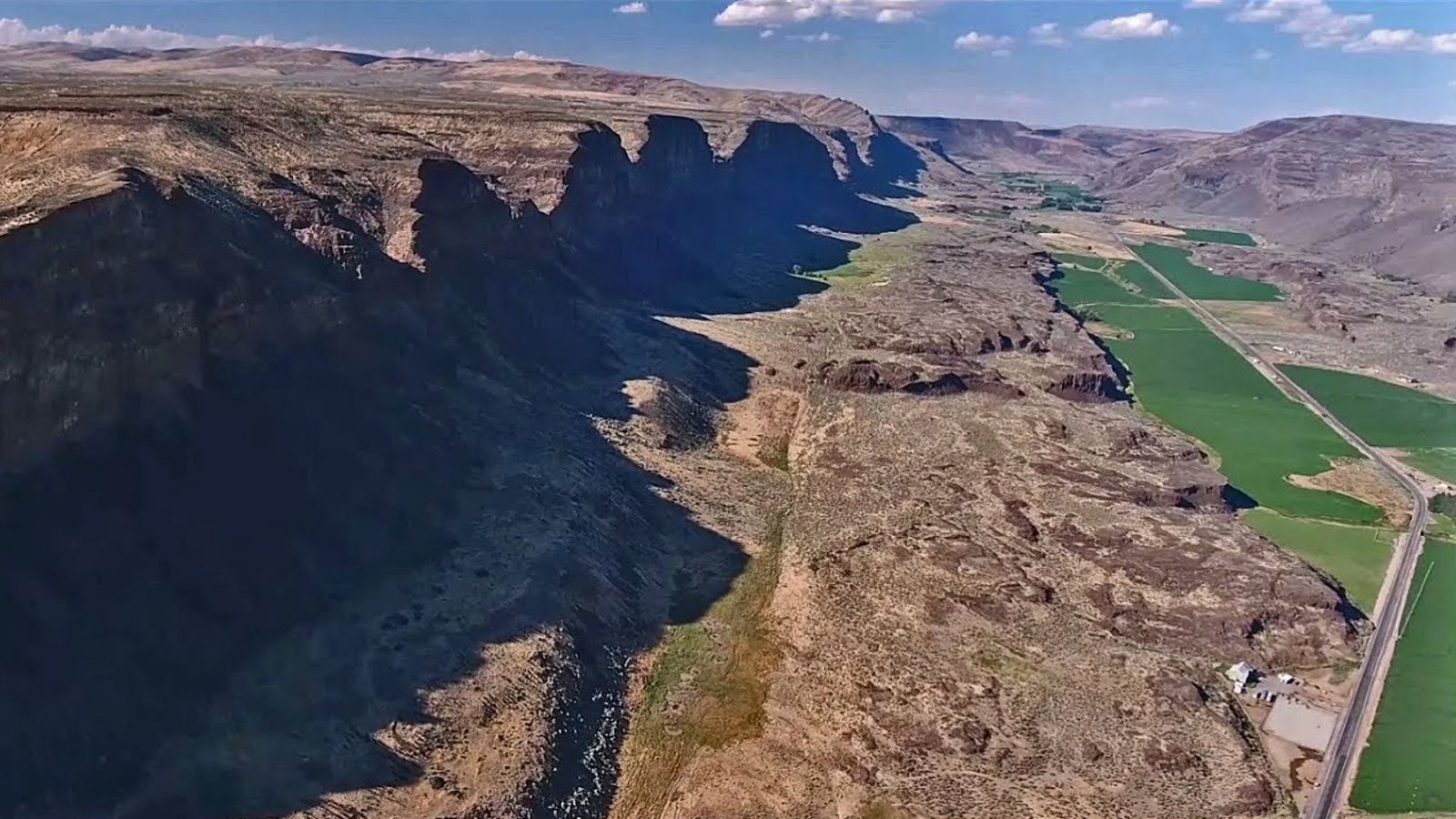
Timing, Topography and Type (“Rock Type” that is) Most of north-central Washington State is covered by lava flows associated with the Miocene Columbia River Basalts. The source of these lava flows came from a series of large fissure eruptions in northeastern Oregon, southeastern Washington and west-central Idaho (similar to the eruptions currently occurring today in Hawaii). These massive outpourings of lava eventually forced the course of the Columbia River to the north and west into what we call today the “big bend”. The nature in which the basalts cooled and cracked, and the structural folding and faulting of the basalts during and after emplacement (Yakima Fold Belt), allowed the Ice Age floodwaters to sculpt large Coulees (Grand and Moses Coulees) and the channeled scabland of eastern Washington. During the Pleistocene (Ice Age) over a period of about two million years, climatic conditions allowed the formation of principally two large continental ice sheets in North America. East of the Rocky Mountains was the Laurentide and to the west of the Rockies was the Cordilleran. Three principal large glacial “lobes” flowed south from the Cordilleran Ice Sheet in Canada into the Pacific Northwest. Those ice lobes are known today as the Puget, Okanogan and Purcell Trench Lobes. The Purcell Trench and Okanogan Lobes played a vital role in controlling ice age flooding and timing of flooding in north-central Washington. During the most recent ice age advance (about 20-12 thousand years ago) the Purcell Trench Lobe was first to arrive blocking predominantly all the drainages in northwest Montana forming a large glacial lake known as Glacial Lake Missoula (GLM). Periodically the ice dam holding back GLM would break allowing Ice Age floodwaters to catastrophically escape. The initial flooding from GLM flowed principally in two directions; to the southwest down the Cheney-Palouse scabland tract, and to the west/northwest into the preexisting Columbia River drainage. During the initial flood/floods the Okanogan Lobe of the Cordilleran had not advanced far enough (south) down the Okanogan River valley to block floodwaters flowing down the Columbia River around the big bend and eventually reaching the Wenatchee area where maximum floodwater depth was almost 1,000 feet deep. Advance of the Okanogan Lobe into the Columbia River valley (Bridgeport/Brewster, WA area) prevented floodwater from flowing the natural course into the Columbia valley north of Wenatchee, deflecting floodwaters into the existing Moses Coulee drainage and possibly down the beginning of Grand Coulee. Floodwaters flowing down Moses Coulee formed a large bar across the Columbia River valley south of Wenatchee, Washington, forming a large temporary lake in the Wenatchee valley until water became deep enough to erode down through the bar and empty the lake. Evidence in the Moses Coulee bar deposit reflects four distinct “basalt” dominated flood beds indicating four separate flooding episodes. Note that about the same time as the Okanogan Ice Lobe advanced into the Columbia valley another glacial lake started forming behind this ice dam, known today as Glacial Lake Columbia (GLC). As GLC filled, flooding continued down Moses Coulee and became more prominent down the beginning of Grand Coulee. Eventually the Okanogan Lobe advanced up onto the Waterville Plateau and blocked the upper portion of Moses Coulee thus ice-age floodwaters could no longer flow down Moses Coulee. With the blocking of Moses Coulee, GLC filled and flowed down the Grand Coulee drainage. During this time, when the Okanogan Lobe blocked the Columbia River drainage around the big bend, natural flow of the Columbia River was down the Grand Coulee drainage. Flood waters flowing down the Grand Coulee went over two separate folds in the basalt. An extension of the Beezley Hills anticline allowed a southern waterfall or “cataract” to form near Soap Lake, Washington. Another fold in the basalt, the Coulee Monocline, located just a few miles north of Coulee City, Washington, was the starting site of the upper falls or cataract. These two cataracts were simultaneously being eroded and “prograded upstream” with each subsequent Missoula Flood down the Grand Coulee drainage. During this time when GLC was at its maximum depth and flowing naturally down Grand Coulee, floods out of GLM would overtop lower divides and flow into the Telford and Wilson Creek floodways eventually meeting up with floodwaters down Crab Creek. As the Purcell Trench Lobe waned and flooding episodes became smaller and more frequent, these smaller flooding events were still able to overtop the lower divides along the south side of the Columbia River drainage due to the high water level in GLC. Eventually the upper cataract in Grand Coulee “breached” the existing Columbia River valley drainage near Grand Coulee, Washington. This breaching lowered the northern opening into Grand Coulee close to 500 feet lower than other divides to the east, making it the predominate flood pathway for the remainder of smaller and more frequent GLM floods. These later smaller GLM floods were not large enough in volume to overtop previous divide drainages to the east of Grand Coulee. The terminus of the lower Grand Coulee is marked by “Dry Falls” cataract. Eventually the Purcell Trench Lobe retreated north (melted back). With no ice dam blocking the drainages in northwest Montana, GLM could no longer exist. The Okanogan Lobe still blocked the Columbia River drainage west of Grand Coulee and GLC existed for about another 300 years after the last GLM flood based on glacial lake sediment (glacial varves) evidence. Eventually the Okanogan Lobe melted enough that one last catastrophic ice age flooding event from the emptying of GLC occurred down the Columbia River valley into the Wenatchee, Washington area and south along the preexisting Columbia River. It is believed that West Bar south of Trinidad, Washington, was formed from the demise of GLC. A small bar adjacent to West Bar may be evidence for one last small flood, after the demise of GLC, down the Columbia River drainage. The existing topography, the timing and position of the Purcell Trench and Okanogan Lobes, and the unique nature in which the basalt eroded
Palouse Falls – A Natural Wonder Anytime of Year

Palouse Falls is visited by thousands each year. The number has increased markedly since it became the official state waterfall of Washington in 2014. Since then, I have listened to people at the park who admit that it is their first visit and are glad they took the time to do it. Most visitors come during the spring runoff when the waterflow is the highest. If that has been your only experience, I invite you to some alternative options. Consider winter after two weeks of sub-freezing weather. The spray from the falls freezes on the surrounding basalt creating an icy wonderland. The longer the cold snap, the bigger the dome of ice builds at the base of the falls. Arrive in the dark before the sun comes up and enjoy the first rays of daylight. Or stay until the sun sets and darkness once again envelopes the falls. If you want another interesting day, arrive in the dark and stay all day until the sun sets. Try to do this on a sunny day and experience the shadows as they move across the falls and sometime in the afternoon you will see a rainbow in the spray. I was recently visiting with my primary physician who reminisced about his time visiting the falls with his father. He said it was almost a spiritual experience which was also expressed by the Palouse Indians who lived in the area. You may have the same feeling, especially when the crowds are much smaller in the off-season and early and late hours. WinterPalouseFalls WinterPalouseFalls FoggyPalouseFalls Previous Next By Lloyd Stoess, Palouse Falls Chapter President
Ice Age Floods National Geologic Trail – Jan. 2023 Update
Missoula Strandlines Eddy Narrows Beacon Rock Cape Disapointment I’d like to start by thanking the Ice Age Floods Institute for letting the National Park Service share regular updates on Ice Age Floods National Geologic Trail. I’m Justin Radford the Trail’s program manager and I look forward to sharing some of the work we are doing. Last summer I had the chance to travel much of the “trail” from Missoula to Cape Disappointment. Having the opportunity to engage firsthand with the visitor experiences offered by our many partners and the amazing landscapes was certainly the highlight of the summer. Photos and stories from these site visits will bring enhancements to both the NPS App and our website in the future. Last summer we also had our second annual Teacher training in Spokane, WA. 43 K-12 Teachers earned credit towards their teaching certificates by learning how to instruct with the story of the Missoula Floods in mind. The calendar for 2023 is looking good. The NPS will be able to bring our traveling Ice Age Floods NGT and Lake Roosevelt NRA Mobile Visitor Center to more events like the Spokane Boat Show and the Sandhill Crane Festival this March in Othello, WA. We will be working to grow our connections with more groups across trail in 2023. Thank you for your support as we continue to grow Ice Age Floods National Geologic Trail. I look forward to seeing you out on the trail.
2022 IAFI Year-in-Review
This is our 6th year preparing a Year-in-Review report for you, our members. We appreciate your continued support, friendship and membership. IAFI is a non-profit organization whose main sources of income are membership dues, donations, profit from field trips and Institute Store sales. For 2022, our total income was $16,675. Our main expenses were contract labor (our membership manager) and liability insurance. For 2021, our total expenses were $9,730. At the end of 2022 we have reserves of $38,938 to cover unplanned expenses, printing informational brochures and to pursue new opportunities related to telling the floods story. Our members provide most of our support and much of the reason for the various materials, activities and events we provide. In 1996, we started with 11 members, and by the end of 2022, as we continue to recover from the pandemic, we have 592 members (427 memberships) from 17 states and British Columbia. While we have several hundred members, most of the work is done by a small group of volunteers, including all your institute and chapter leaders. We welcome anyone interested in helping develop and conduct our programs., so if you are interested please contact us at IAFInstitute@gmail.com or reach out to your chapter president or one of our board of directors. INSTITUTE PROGRAMS This year, while continuing to host zoom presentations, we started to have more in-person activities, although compared to a normal year, we had relatively few activities in community social settings, such as county fairs, school programs, working with other organizations, etc. We have continued our outreach to inform and educate the public about the Ice Age Floods and their long-lasting impact on our area is a key part of the IAFI mission. We have significantly increased our online outreach, typically garnering thousands of views each week through interesting articles and features on our Facebook, website and newsletters, while our local chapter programs are possibly the most effective way we meet this challenge with lectures, field trips, hikes and presentations. LECTURES During 2022 we had both on-line Zoom presentations and in-person lectures. Over 500 people attended 18 on-line lectures and hundreds more viewed them when they were posted on YouTube. We had 27 in-person lectures which were attended by over 1200 people. FIELD TRIPS Ellensburg chapter hosted two field trips: 1) Glacier Lake Foster on the Waterville Plateau and 2) Landforms and Landscapes of the Swauk Watershed. Lake Missoula chapter hosted a field trip to the Bison Range. Coeur du Deluge chapter conducted a walking field trip with Farragut State Park Docents to increase their knowledge of local Ice Age Floods features, emphasizing the location of these features within Farragut Park, how these features were formed, and how they influenced land use, transportation and recreational use. Palouse Falls Chapter hosted a field trip to Palouse Falls. Wenatchee Valley Erratics Chapter hosted several field trips: 1) Talk and field trip for the Tobacco Root Geological Society, 2) Field trip focusing on the Geology of the Wenatchee Valley, 3) Geology of the Leavenworth/Lake Wenatchee area. HIKES Palouse Falls chapter hosted a hike/lecture on the Age of Quartzite Buttes in the Palouse Region. Lake Lewis chapter hosted a hike/lecture to Twin Sisters in Wallula Junction. Quite cold and windy but a cool experience. Cheney-Spokane chapter hosted 3 hikes: 1) Dishman Hills Area, 2) along a proposed trail that the Spokane conservation District would like to develop, and 3) a geologic hike that explored the new Waikiki Springs Conservation Area on the Little Spokane River in conjunction with the Inland Northwest Land Conservancy. Glacial Lake Missoula Chapter hosted a hike/talk to Dean Stone Mountain. PRESENTATIONS FOR SCHOOLS AND COMMUNITY EVENTS To help people learn about the floods we are continually developing new ways of communicating information to people. Some examples from 2022: Our Board of Directors Education Committee has been working on developing a 4th grade curriculum about the Ice Age Floods. Lake Lewis Chapter and The Coyote Canyon Mammoth Site near Kennewick – Approximately 3000 people, mostly elementary school kids on school field trips, including quite a few homeschoolers, visited the mammoth site that we are excavating. The mammoth is buried in Ice Age Floods graded beds, so as we study the mammoth’s burial, we also study the floods. The stories are intertwined; hence each talk must include the Floods story. Many other kids came to the site on youth group field trips or accompanied their parents at community events. About 1000 adults and some kids also visited with us at various community events such as Heritage Days at Sacajawea State Park, The SandHill Crane Festival in Othello, The Richland Library, The Reach Interpretive Center, River Fest at Columbia Park in Kennewick and more. Cheney-Spokane Chapter – Presented the floods story in 20-minute segments to three fourth grade classes with the Science Coordinator for Jefferson Elementary School, and exhibited at the Blue Waters Bluegrass Festival at Medical Lake, WA, visiting with 147 people. Glacial Lake Missoula Chapter – Hosted a booth and tent at the city-wide walk-in Fort Missoula Spring Event for many passersby, and continued preparations to install glacial Lake Missoula high water indicator rocks throughout the area. Coeur du Deluge Chapter – Led a four-hour tour in conjunction with the Idaho Master Naturalist Program on the Shawnodese tour boat along the north shore of Lake Pend Oreille and into the Clark Fork River delta viewing the Purcell trench, the location of the ice dam and the steep wall carved by the glaciation. Columbia River Gorge Chapter – Worked to redesign and rebuild the IAFI.org website, andcreated new Conference displays for IAFI. Lower Grand Coulee Chapter – Hosted a booth at the Ice Age Floods Fest at the Dry Falls Visitor Center, and one at the Quincy Farmer Consumer Awareness Day with IAFI talks and tours, videos and info displays. Palouse Falls Chapter – Hosted an information booth at STEAM night at Lacrosse School and at the Grand Opening of remodeled Connell branch for Mid-Columbia Libraries, participated in Neighbor meeting Neighbor booth in Washtucna, a booth at Wheatland Fair, and a chapter appreciation picnic
Othello Sandhill Crane Festival -March 24-26, 2023

The Othello Sandhill Crane Festival announced the 2023 theme as “Silver Anniversary, Celebrating Our Annual Visitors.” The 25 th annual festival will be held March 24-26, 2023 in Othello Washington. We are excited to be celebrating our 25th year! The festival celebration of the spring migration of the Sandhill cranes offers a variety of events for the whole family to enjoy and learn. The festival will be in the same locations as last year. The lectures will be held at the Othello Nazarene Church, 835 S 10 th Ave, Othello, WA. The Church is next door to McFarland Middle School where we will have the children’s art projects, the vendors, the photo booth, the Rotary breakfast, and the art contest. We will be utilizing both facilities. Food trucks will be available for lunches. Online registration opens on February 6, 2023. Visit the Othello Sandhill Crane Festival website for more information on the events at Website: othellosandhillcranefestival.org. Follow us for updates on Facebook: www.facebook.com/Othello-Sandhill-Crane-Festival Cathy Nowak will be one of the featured speakers on Saturday, March 25, at 7:30pm. Cathy will be speaking about Sandhill Crane nests and how experience matters, with both words and photos. Dr. Kaeli Swift will be the other featured speaker on Friday, March 24, at 7:30 pm. This lecture will require masks. Swift will explore commonly asked questions about crows, how crows have co-evolved with people, and what crows and other corvids can teach us about the nature of intelligence. Saturday, March 25, the lectures will cover cranes, birds, Ice Age Floods, the Drumheller Channel, and much more. We are planning tours by bus, bike, boat, car and self-directed, crane viewing tours will be back. Some tours will be set up over two weekends. The Children Activities Committee will have fun activities for kids such as binoculars made of toilet paper rolls to use for “birding” in the gym by finding pictures of various birds, origami folded crane mobiles, mask making and many other activities. We will again have the free photo booth to take your picture with a digitized Sandhill crane in the background to take home as a memento.
Bering Land Bridge Formed Surprisingly Late During Last Ice Age
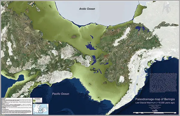
By reconstructing the sea level history of the Bering Strait, scientists found that the strait remained flooded and the Bering Land Bridge connecting Asia to North America did not emerge until around 35,700 years ago, less than 10,000 years before the height of the last ice age (known as the Last Glacial Maximum), and not long before humans are thought to have begun migrating into the Americas. The new findings indicate that the growth of the ice sheets—and the resulting drop in sea level—occurred surprisingly quickly and much later in the glacial cycle than previous studies had suggested. “It means that more than 50 percent of the global ice volume at the Last Glacial Maximum grew after 46,000 years ago,” said Tamara Pico, assistant professor of Earth and planetary sciences at UC Santa Cruz and a corresponding author of the paper. “This is important for understanding the feedbacks between climate and ice sheets, because it implies that there was a substantial delay in the development of ice sheets after global temperatures dropped.” Global sea levels drop during ice ages as more and more of Earth’s water gets locked up in massive ice sheets, but the timing of these processes has been hard to pin down. During the Last Glacial Maximum, which lasted from about 26,500 to 19,000 years ago, ice sheets covered large areas of North America. Dramatically lower sea levels uncovered a vast land area known as Beringia that extended from Siberia to Alaska and supported herds of horses, mammoths, and other Pleistocene fauna. As the ice sheets melted, the Bering Strait became flooded again around 13,000 to 11,000 years ago. The new findings are interesting in relation to human migration because they shorten the time between the opening of the land bridge and the arrival of humans in the Americas. The timing of human migration into North America remains unresolved, but some studies suggest people may have lived in Beringia throughout the height of the ice age. “People may have started going across as soon as the land bridge formed,” Pico said. The new study used an analysis of nitrogen isotopes in seafloor sediments to determine when the Bering Strait was flooded during the past 46,000 years, allowing Pacific Ocean water to flow into the Arctic Ocean. First author Jesse Farmer at Princeton University led the isotope analysis, measuring nitrogen isotope ratios in the remains of marine plankton preserved in sediment cores collected from the seafloor at three locations in the western Arctic Ocean. Because of differences in the nitrogen composition of Pacific and Arctic waters, Farmer was able to identify a nitrogen isotope signature indicating when Pacific water flowed into the Arctic. Pico, whose expertise is in sea level modeling, then compared Farmer’s results with sea level models based on different scenarios for the growth of the ice sheets. “The exciting thing to me is that this provides a completely independent constraint on global sea level during this time period,” Pico said. “Some of the ice sheet histories that have been proposed differ by quite a lot, and we were able to look at what the predicted sea level would be at the Bering Strait and see which ones are consistent with the nitrogen data.” The results support recent studies indicating that global sea levels were much higher prior to the Last Glacial Maximum than previous estimates had suggested, she said. Average global sea level during the Last Glacial Maximum was about 130 meters (425 feet) lower than today. The actual sea level at a particular site such as the Bering Strait, however, depends on factors such as the deformation of the Earth’s crust by the weight of the ice sheets. “It’s like punching down on bread dough—the crust sinks under the ice and rises up around the edges,” Pico said. “Also, the ice sheets are so massive they have gravitational effects on the water. I model those processes to see how sea level would vary around the world and, in this case, to look at the Bering Strait.” The findings imply a complicated relationship between climate and global ice volume and suggest new avenues for investigating the mechanisms underlying glacial cycles. In addition to Pico and Farmer, the coauthors include Ona Underwood and Daniel Sigman at Princeton University; Rebecca Cleveland-Stout at the University of Washington; Julie Granger at the University of Connecticut; Thomas Cronin at the U.S. Geological Survey; and François Fripiat, Alfredo Martinez-Garcia, and Gerald Haug at the Max Planck Institute for Chemistry in Germany. This work was supported by the National Science Foundation. Published in Proceedings of the National Academy of Sciences. Reprinted from UC Santa Cruz Newsletter, By Tim Stephens