Celebration Park – Home of Melon Gravel
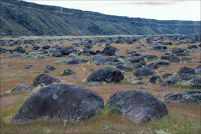
17,000 years ago, a massive Ice Age lake – now called Lake Bonneville – filled a large portion of present-day Utah. As temperatures changed, the influx of ice melt caused the lake level to rise. In addition, the Bear River, once a tributary of the Snake, was diverted by volcanic activity back into Lake Bonneville. These factors ultimately led to the breaching of a sedimentary rock dam at Red Rocks Pass, Idaho. There was only one ice-age Bonneville Flood because Lake Bonneville broke through a rock dam, unlike the Missoula Floods whose glacial ice dam repeatedly dammed Glacial Lake Missoula, then broke and rebuilt. 1,100 cubic miles of Lake Bonneville water rushed through the Snake River Canyon, and it took only six weeks for Lake Bonneville to empty the equivalent volume of modern-day Lake Michigan. The Great Salt Lake we know today is a remnant of Lake Bonneville, but at one tenth the size, it is a mere puddle compared to what the lake used to be. The power of this catastrophic flood widened canyons as the force of the water pulled huge chunks of basalt off the cliffs and tumbled them around, smoothing their jagged edges along the way. As the canyon width narrowed, the force and velocity of the flood increased. Wherever the canyons widened, the flood lost force and velocity, the waters slowed and began dropping its bedload – in this case, giant tumbled basalt boulders instead of your typical river gravel. These flood-rounded boulders, named melon gravel due to their distinct shape, are scattered over vast areas of land. The rocks’ unique outlines and smooth surfaces caught the eye of Native American tribes in the area, who have used them as canvases for petroglyphs for thousands of years. Visitors can see the medium sized flood deposits just outside the visitor center, or hike upriver to see gigantic melon gravel the size of heavy-duty trucks. Celebration Park is located in the Snake River Canyon, approximately 23 miles south of Nampa, Idaho. It is home to an enormous melon gravel field deposited by the Bonneville Flood.
The Bowl & Pitcher at Riverside State Park
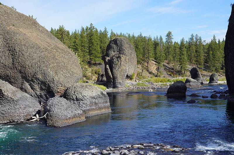
The Bowl and Pitcher is a rock formation along the Spokane River and one of the most scenic sites in the area, with basalt cliffs rising 500 feet above the river and large blocks of basalt in the river causing large rapids. The “Bowl” is a circular depression in the river and the “Pitcher” is a large detached block of highly fractured basalt. The geology of Spokane’s Bowl and Picher features dramatic basalt cliffs carved out of the flows from the Columbia River Basalt Group (CRBG), which reached this area 16 million years ago. There are river and flood deposits of sand and gravel, with granitic boulders forming terraces on the east side of the river, and huge blocks of basalt, causing the Dragon Tooth rapids, downriver from the Bowl and Pitcher. How did those rocks get there? The Spokane and Columbia rivers occupy a long, mostly bedrock canyon near the northeastern boundary of the Columbia Plateau. Glacial Lake Columbia, which formed behind the Okanogan ice lobe, occupied all of the Spokane River and a portion of the Columbia drainage basin during the last Ice Age. Then the glacial Lake Missoula outburst floods first surged over the Columbia Basin beginning around 17,000 years ago, ripping away the CRBG and other bedrock from Bayview, Idaho, to the Pacific Ocean. These floods also deposited a thick sequence of flood gravel in the valley. As Lake Columbia water level dropped, the Spokane River began to remove the sand and gravel fill. Subsequent floods continued to remove the flood deposits, leaving the basalt benches on the west side of the river and the terraces on the east side. Riverside State Park is located northwest of Spokane and consists of over 9000 acres along the Spokane and Little Spokane Rivers. The park is the second largest state park and has many recreational activities including, camping, hiking, mountain biking, horseback riding and boating (Discover Pass required). There are two view points for the Bowl and Pitcher. The first is from a small parking lot off the entrance road from Aubry White Parkway that provides an elevated view of the site. The main parking area is down along the river with a picnic area and a network of trails. From the parking lot you can follow the wheelchair accessible path across the suspension bridge over the Spokane River. From the bridge you can enjoy a view of the features that give the site its name. The original bridge was built in 1942 by the Civilian Conservation Corps. The existing bridge, based on the same plans, opened in 1998. On the west side of the river, you can access a network of trails along the river or climb up along the bluffs above the river.
Discovering the Telford Tract: A Hidden Gem in the Channeled Scablands

Traveling east along Lake Roosevelt from the Grand Coulee brings you closer to an area steeped in geological and historical intrigue. This journey not only unveils the legacy of ancient Glacial Lake Columbia but also leads to one of the most captivating sections of the Channeled Scablands: the Telford Tract. A critical player in the narrative of Ice Age floods, the Telford Tract offers a striking example of the power and scope of these ancient cataclysmic events. The Role of Glacial Lake Columbia The current Lake Roosevelt occupies much of the previous western Glacial Lake Columbia area, a massive lake formed when glacial ice blocked the Columbia River’s southwestward flow. The lake’s height and timing had a dramatic influence on the routes taken by the incoming Glacial Lake Missoula floodwaters. A portion of these immense floods, among the largest known in Earth’s history, surged south through the Telford region, carving canyons, depositing sediments, and shaping the land into what we now call the Channeled Scablands. J Harlen Bretz, the geologist who first described the scablands in detail, outlined these pathways or “tracts” in his seminal 1928 paper, The Channeled Scabland of Eastern Washington. Among the four major scabland tracts Bretz identified, the Telford-Crab Creek Tract is particularly significant for its geological features and historical context: “The Telford-Crab Creek scabland tract…heads in the vicinity of Telford station…as wide as the Cheney-Palouse River tract…convergence of all these (and of all but one of the Cheney-Palouse River divergences) occurs in a wide shallow structural sag (Quincy Basin) in the western part of the plateau. In this basin is the largest single area of gravel left by the glacial waters…There is continuous scabland northward from all channel heads of this tract across the plateau divide to the limits reached by the ice sheet.” Exploring the Telford Tract Today The Telford Tract, adjacent to the Lake Roosevelt National Recreation Area, provides an unparalleled opportunity to witness the scars of Ice Age floods. Once a 900-acre homestead, the tract’s eroded flood channels and gravel deposits serve as a testament to the massive forces that shaped this region. Managed by the Bureau of Land Management, the Telford Recreation Area invites visitors to explore this geological marvel. Hiking trails weave through remnants of these ancient waterways, offering a chance to immerse yourself in one of the major routes of the Missoula Floodwaters. Check out these resources to help plan your visit: BLM Telford Recreation Area and Washington Trails Association: Telford Recreation Area Beyond Telford: Exploring Upper Crab Creek For those looking to expand their journey through this region, the Telford Tract’s channels eventually connect to Crab Creek, another iconic feature shaped by glacial waters. The Upper Crab Creek Field Trip offers a deeper dive into this fascinating landscape, combining geological exploration with breathtaking scenery. In 2013 Karl Lillquist and Jack Powell created an Upper Crab Creek Field Trip guide for the Ellensburg Chapter of the Ice Age Floods Institute. A Landscape Worth Protecting The Telford Tract exemplifies the dynamic history of the Channeled Scablands and the profound environmental changes brought about by Ice Age floods. As part of the Ice Age Floods National Geologic Trail, this area’s preservation ensures that future generations can continue to learn from and appreciate its unique geological story. Whether you are a geology enthusiast, history buff, or outdoor adventurer, the Telford Tract promises an unforgettable experience. This landscape, shaped by forces beyond imagination, stands as a humbling reminder of nature’s power and its enduring impact on the Earth’s surface.
Explore Lake Roosevelt National Recreation Area
The Lake Roosevelt National Recreation Area serves as a striking landmark that narrates a dramatic geological history shaped by colossal natural forces. Greatly influenced by the Missoula Floods, this area, part of the Ice Age Floods National Geologic Trail, reveals not only stunning landscapes but also insights into the Earth’s geological story. Understanding this region offers a glimpse into the powerful events that occurred between 13,500 and 18,500 years ago, as well as the enduring environmental significance of these features. Lake Roosevelt and Grand Coulee Dam Lake Roosevelt, created by the Grand Coulee Dam in the 1930s, serves multiple purposes: from water storage and hydroelectric power generation to recreation and wildlife preservation. The lake provides a crucial habitat for various species and supports a vibrant ecosystem and is home to a range of fish species, including walleye, rainbow trout, and Kokanee salmon. The surrounding lands offer habitats for birds and other wildlife, contributing to ecological balance. With over 400 miles of scenic shoreline, the 150 mile long goes from Grand Coulee nearly to the Canadian board and is a haven for outdoor enthusiasts. The lake offers expansive waters perfect for various forms of boating. Anglers can enjoy abundant fishing opportunities year-round. 32 different campgrounds such as Spring Canyon close to Grand Coulee, WA offer numerous places to extend your overnight stays with these stunning landscapes. Historical Heritage The Lake Roosevelt area holds historical significance for the Confederated Tribes of the Colville Reservation and the Spokane Tribe of Indians, highlighting the intertwined relationship between Native heritage and the natural landscape. The National Park Service (NPS) supports Bureau of Reclamation management of Bakes Lake, Coulee Dam, and Lake Roosevelt. NPS works with Washington State Parks throughout the Grand Coulee Corridor and along with the Tribes and Washington Department of Natural Resources, oversees recreation on the water and lands of Lake Roosevelt NRA. Our collective efforts work to ensure that these natural treasures are preserved for future generations. Visitors to the area can engage with a variety of programs and informational resources that enhance their understanding and respect for the environment. Power in Nature The Grand Coulee and Lake Roosevelt National Recreation Area stand as remarkable examples of nature’s power and the intricate tapestry of geological history. From the cataclysmic Missoula Floods that sculpted the landscape to the thriving ecosystems supported by Lake Roosevelt, this region offers an unparalleled opportunity for exploration and discovery. Whether you are an avid hiker, a passionate angler, or a curious geology enthusiast, this area provides not only recreational activities but also a deeper connection to the Earth’s history. As we delve into the breathtaking scenery and rich cultural heritage of this national recreation area, we are reminded of the dynamic forces that shape our world. The Grand Coulee and Lake Roosevelt invite each visitor to engage with the past while understanding the importance of stewardship for future generations. This stunning landscape not only captivates the eye; it expands our knowledge of nature and our place within Ice Age Floods National Geologic Trail.
Must See Floods Features in Northern Idaho

SOME LOCAL NORTHERN IDAHO ICE AGE FLOODS and GLACIAL FEATURES Purcell Trench – This structurally formed valley became the passageway for the Purcell Ice Lobe that divided into five glacial sub-lobes. The east moving sub-lobe blocked the Clark Fork River forming Glacial Lake Missoula, the source of the Ice Age Flood waters. Other sub-lobes modified and deepened the basin now occupied by Lake Pend Oreille or helped define several important N-S transportation routes. The Purcell Trench is visible from City Beach in Sandpoint and Schweitzer Mountain Rd. Hwy 95 follows the Purcell Trench from Sandpoint to beyond Bonners Ferry. Cabinet Gorge – Contact of Pleistocene Ice and Glacial Lake Missoula Water – Although the contact of the Pleistocene Ice and the lapping waters of Glacial Lake Missoula was in flux as the glacier advanced and retreated, the Cabinet Gorge is considered by many to be a likely location of the terminus of the Clark Fork sub-lobe that blocked the drainage of the Clark Fork River. Evidence of glacial erosion and till deposits indicate glaciation; however, flood deposits on the south side of the river attest to Ice Age flooding. Cores taken during the construction of the Cabinet Gorge Dam suggest multiple stages and events of ice damming. An AVISTA maintained viewpoint at the Cabinet Gorge Dam with Ice Age Floods signage provides an excellent location to ponder the formation and disintegration of the ice plug blocking the Clark Fork River. Glacial Striations – Striations can be viewed along Hwy 200 east of Hope and on the south side of Castle Rock east of Clark Fork. Glacial/Flood Related Erratics – Large and small erratics cover the glacial and flood modified landscape. Large erratics can be seen along Hwy 200 east of Clark Fork, in Sandpoint’s City Beach and in Farragut State Park. A large pile of erratics excavated from flood deposits are visible on the west-side of Hwy 95 south of the Hoodoo Channel. A giant ice-rafted flood related erratic weighing over 1,600 tons is located on the east-side of Hwy 41 near Twin Lakes. Lake Pend Oreille – Cross-section morphology, depth, and sediments – This is where it all started! Lake Pend Oreille is the largest lake in Idaho and the deepest lake in the Pacific Northwest and the 5th deepest in the US. The lake level is 2062 ft above sea level with depths over 1,000 feet and an additional layer of over 1,500 feet of glacial-fluvial deposits going to bedrock, with the surrounding terrain as high as 6002 ft. The glacially modified U-shaped bedrock valley, cut to approximately 600 feet below sea level, was formed by the Pend Oreille glacial sub-lobe. This glacial sub-lobe was up to 4,000+ ft. thick and 30+ miles wide. It was the ice plug responsible for blocking the Clark Fork River. It collapsed catastrophically as often as about every 10-60 years, releasing 40-100 Ice Age Floods. The location of the lake is probably related to an old river valley controlled by faults. The Lake Pend Oreille basin was carved by the repeated advances of Pleistocene ice and scoured by ice age floods. With the waning of ice age flood waters, the basin was, and continues to be, filled with glacial outwash and flood deposits. The lake is dammed at the south end by thick glacial and flood deposits the mark the beginning of the “Outburst Deposits”. There is a pullout on Hwy 200 approximately one mile west of Hope with signage already established that provides a great view looking south across Lake Pend Oreille to the Green Monarch Mts. Another view of the former ice plug location along Hwy 200 is the mouth of the Clark Fork River at the Clark Fork Drift Yard. Giant Current Dunes or MegaRipple Marks – One of Bretz’ most important pieces of evidence for catastrophic flooding was the “giant current dunes.” These large-scale bedforms appeared as patterns of parallel ridges and swales on many aerial photographs in the flood channels in the scabland of Washington, but had escaped recognition from the ground because of their size. Giant Current Dunes are visible west of Clark Fork near Castle Rock; however, the most prominent and visible Giant Current Dunes are located several miles east of Spirit Lake along Hwy 54 where the highway cuts through the dunes showing their undulating profile. The location of many of the telephone poles on the crest of these dunes accentuates these landforms. The dunes form transverse to the current direction, and form cusps that are convex upstream, with arms that point downstream. Furthermore, the size of the cusps appears to decrease in the direction of lower velocity. Internally, the dunes consist of gravel and pebble foresets. Giant current dunes exhibit an asymmetrical profile with the downstream (lee) slope steeper than the upstream slope. Crests range from 20 to 200m apart and heights range from 1 to 15m (Baker and Nummedal, 1978) and are among the largest measured throughout the Floods area. The Spirit Lake current dunes can also be easily recognized from the air by their characteristic pattern, accentuated by vegetation. This dune field is immediately in the path of the breakout from Lake Pend Oreille, and experienced some of the highest energy flows. Rhythmites – Rhythmites are glaciolacustrine sediments associated with flood events and are useful in attempting to determine the number of Ice Age Floods. A 112-foot cross-section of rhythmites is located at the junction of East Fork Creek and Lightning Creek approximately 6.5 miles northeast of Clark Fork along Lightning Creek Road (NF-419). Proglacial Deposits – This type of deposit is found associated with most of the drainages on the south side of the Clark Fork Valley and extend from the mouth of the Clark Fork River to nearly Thompson Falls in Montana. These sediments are glacio-fluvial deposits deposited in contact with the ice and therefore provide evidence of glaciation in the Clark Fork River drainage. The associated geomorphic features formed by these deposits are referred to as “kame deltas”. The gravel pit associated with Dry Creek (approximately 8 miles west of Clark Fork