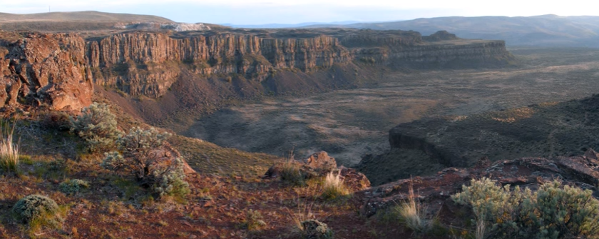
Frenchman Coulee
Frenchman Coulee Ice Age Floods National Geologic Trail Frenchman Coulee is a short drive north and west from the Silica Road exit 123 off US-90, along the Old Vantage Road. It is one of the most beautiful features left behind by the great Ice Age Floods. Several of those massive floods, up to 700 ft (213 m) deep, created Frenchman Coulee, its Potholes Coulee neighbor to the north, and scoured the bizarrely eroded surface of Babcock Bench, preferentially eroding weaker rock out of the top of the Grand Ronde Member of Columbia River Basalt. Frenchman Coulee is actually a dual coulee and cataract system, Frenchman Coulee and Echo Basin, separated by a remnant rock blade that sports tall basalt columns attracting rock climbers like bees to flowers. The Feathers is probably the most popular climbing area in the region. Hiking trails, some barely discernible, lead along and atop the rock blade, affording spectacular views of both coulees. Frenchman Coulee also has a waterfall in the eastern section of the Coulee that is accessible by foot. Other hiking and biking trails explore the floor of the coulee and continue over 15 miles north along Babcock Bench, perched high above and adjacent to the Columbia River, past Potholes Coulee and on to Crescent Bar. Quick Facts Location: Old Vantage Highway, Quincy, WA 98848 A primarily destination for hikers, mountain bikers and rock climbers with the fascinating rock formations of the Gorge making for a great challenge
Ginkgo Petrified Forest

Ginkgo Petrified Forest State Park Interpretive Center Ginkgo Petrified Forest State Park is a registered National Natural Landmark, lyng just north of US-90 at exit 136, and west of the Wanapum Lake portion of the Columbia River at Vantage, WA. Established in 1935, it is home to a rare and vast collection of petrified trees. The park covers 7,124 acres, including an interpretive trail, on which visitors can hike and see protected displays of several of the petrified tree species. The abundance of tree species discovered here make it one of the most diverse collections of petrified trees in North America. The trees are thought to have been carried down the flanks of ancient volcanoes from various ecological zones by floods and lahars., and then deposited and buried in an ancient lakebed. Slowly, cell-by-cell, the tree cells were replaced by dissolved minerals in the groundwater, resulting in exact rock replicas of the trees. The park comprises three primary locations. Drive a couple of miles up the Old Vantage Highway to the Ginkgo “Trailside Museum”, constructed by the Civilian Conservation Corps in the 1930s, and recently updated with a new interpretive exhibit. From here, 1.25 miles of the Trees of Stone Interpretive Trail wind past more than 20 petrified logs protected in their original settings with signage about the petrified wood. Birders look for golden eagles, sage thrashers, Say’s phoebes and many other species. Elk and bighorn sheep also frequent this area. A total of 3 miles of hiking trails are at this site. Perched on a cliff face carved out by Ice Age floods, Ginkgo Petrified Forest Interpretive Center overlooks the Wanapum Lake portion of the beautiful Columbia River. The access road is marked by a small sign on Main St. just north of the small town of Vantage. The interpretive center was constructed by the Civilian Conservation Corps during the Great Depression and was later expanded in 1951.The air-conditioned Center museum features a beautiful collection of more than 30 varieties of petrified wood, videos and park volunteers to inform visitors about the history behind this unique and unusual petrified forest. They can also tell about the powerful Ice Age Floods, responsible for the visually captivating surrounding landscape. Outside the Center, visitors can enjoy the day-use/picnic area, view the scenic river, touch petrified wood and learn more about the Ice Age Floods. Ginkgo Petrified Forest State Park is also home to the Wanapum Recreation Area about 3 miles south of US-90, which features 27,000 feet of freshwater shoreline and hosts a 50 site, full hook-up campground, a day use area with a swim beach, and a boat launch. Quick Facts On the Ice Age Floods National Geologic Trail Location: 4511 Huntzinger Rd, Vantage, WA 98950 99371 MANAGED BY: Washington State Parks A Discover Pass is required for vehicle access to state parks for day use. For more information about the Discover Pass and exemptions, please visit the Discover Pass web page.
6 New ‘Nick On The Rocks’ Episodes
6 new short episodes of ’Nick On The Rocks’ aired on PBS this past winter! Each of these gems are short enough to be taken in by even the busiest of us, and yet have enough information to whet the appetite of even the most intensive of us. Nick is masterful in his presentations and who he draws in to help. Watch them all, you won’t be disappointed. Lake Chelan – Battle of the Ice Sheets (w/ Chris Mattinson) Click HERE to watch. 5 minutes. Chasing Ancient Rivers (w/ Steve Reidel) Click HERE to watch. 5 minutes. Seattle Fault (w/ Sandi Doughton) Click HERE to watch. 5 minutes. Bridge of the Gods Landslide (w/ Jim O’Connor) Click HERE to watch. 5 minutes. Columns of Basalt Lava Click HERE to watch. 5 minutes. Ancient Volcanoes in the Cascades (w/ Daryl Gusey) Click HERE to watch. 5 minutes.
Castle Lake Basin
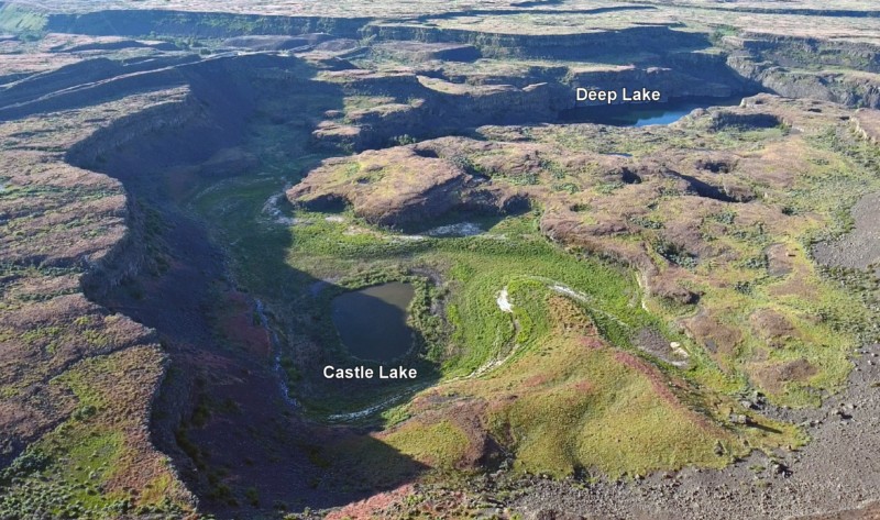
Castle Lake fills a plunge-pool at the base of a 300-ft tall cataract at the opposite (east) end of the Great Cataract Group from Dry Falls, above the east end of Deep Lake. A set of steel ladders put in place during the construction of the Columbia Basin Irrigation Project allow for a safe descent into the basin. In the basin are great views of giant potholes, the flood-sheared face of Castle Rock, as well idyllic Deep Lake. The Castle Lake Basin lies along the east end of the Great Cataract Group. At the base of the cataract is lovely blue-green Castle Lake plunge pool nestled into the rock bench below. Castle Lake lies within a single recessional cataract canyon eroded down to a flood-swept, pothole-studded rock bench that stands 100 feet above Deep Lake. This is the same rock bench of Grande Ronde Basalt where dozens of potholes occur at the opposite (western) end of Deep Lake. Castle Rock itself is an isolated butte along the west side of the Castle Lake basin. It is a faceted butte escarpment nearly sheared off by monstrous flood forces moving across the cataract.
Williams Lake Cataract Video
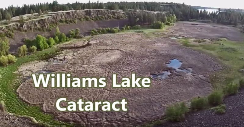
Williams Lake Cataract is an ancient, dry waterfall left behind along the Cheney-Palouse Scabland Tract in eastern Washington after Ice Age flooding recessionally ripped out underlying basalt to produce this massive cataract. Video produced by Bruce Bjornstad, Ice Age Floodscapes
The Great Blade – Bruce Bjornstad Video
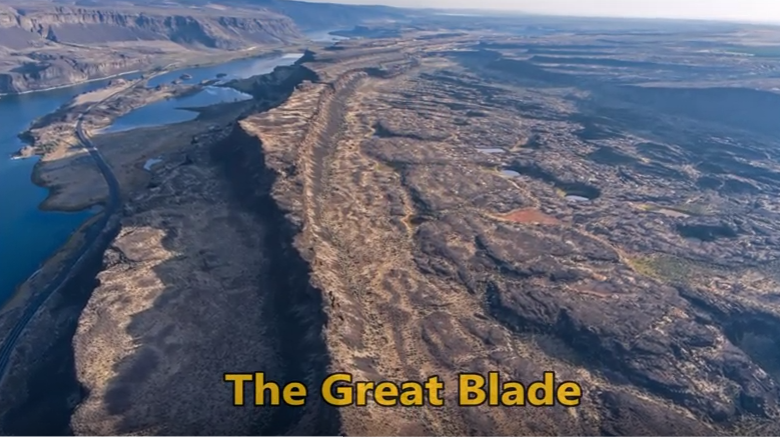
“…there were a few double falls each member of which receded at approximately the same rate, so that the island in mid-channel became very much elongated, like a great blade, as the falls receded and the canyons lengthened.” J Harlen Bretz (1928) A tall, narrow basalt ridge, coined “The Great Blade” by J Harlen Bretz, parallels Lower Grand Coulee east of Lake Lenore. The blade is the product of Ice Age floods that repeatedly rampaged Grand Coulee as recently as 15,000 years ago. Most of the floods appear to have come from sudden outbursts from glacial Lake Missoula. During flooding the coulees on either side of the Great Blade were filled with up to 800 ft turbid water. The largest floods also overtopped the Great Blade, submerging the site under at least another 100 ft of floodwater. On the west side of the blade, where Lake Lenore is located, lies the Lower Grand Coulee, which ultimately migrated 10 miles northward – all the way to Dry Falls. On the east side of the blade is the higher East Lenore Coulee, which migrated a shorter distance (~3 mi) to Dry Coulee. Like a gigantic rib the Great Blade is tallest and narrowest at its south end, widening to the north. The blade extends for almost four miles from where the head of East Lenore Coulee intersects Dry Coulee. In places the blade narrows to as little as 800 ft wide. Video produced by Bruce Bjornstad for Ice Age Floodscapes
Palagonite Maar Near Hood River
Palagonite Maar Just west of Hood River is a distinctive, short (<500 m) section of stratified orangeish oxidized volcanic tephra and highly fractured lava bombs. This mixture of oxidized volcanic particles ranging down to sub-micrometer sizes mixed with the larger lava bombs is a palagonite tuff. This deposit is the result of a “phreatic” eruption when lava erupted explosively from a volcanic vent through water, like a lake or groundwater. The rapid heating expansion of water to steam blew the rising lava out of the vent as tephra (volcanic rock fragments) ranging from ash-size to volcanic bombs (blobs of lava) up to several inches in diameter. Rapid oxidation of the water-quenched tephra turned the iron content to rust, producing the orangeish color of the tephra. The lava bombs were heavily fractured due to rapid cooling of the blob as it came in contact with the water and as it flew through the air. The tephra deposits dip inward on either side of a central gap toward the gap, with NE dips in the western section and NW dips in the eastern section, forming an inverted cone that converges downward toward the central gap. This feature is a “maar” deposit; an inverted cone of tephra and lava resulting from rapidly rising magma interacting with groundwater causing a steam-driven explosive eruption that builds the surrounding maar. The vent of this maar was in the area of the central gap.
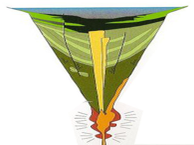
Lava + Ice + Water = Floods Geology
Floods of lava (Columbia River Basalts) and Ice Age Floods of water (Lake Missoula floods and the Bonneville Flood) are world-famous topics among geologists. To have both sets of floods in the same area means the geology of the Inland Northwest is truly Disneyland for Geologists! The program begins in Lewiston, Idaho where the floods of lava and water are beautifully on display near the mouth of Hells Canyon. Early on, the Columbia River Basalts – eruptions of fluid lava from deep fissures – are featured. The Missoula Floods from Montana and the Bonneville Flood from Utah – the Ice Age Floods – are surveyed at an introductory level. And finally, the interaction between bedrock and fluid dynamics of the floodwater are highlighted through discussion of Ice Age erosional and depositional landforms. Key locations in the Pacific Northwest are featured, including the Snake River Canyon, Grand Coulee, Dry Falls, the Drumheller Channels, Wallula Gap, and the Columbia River Gorge. Tom Foster and Nick Zentner (Central Washington University) had been hiking together in eastern Washington for years. The result? A series of short videos that showcase geological wonders in the Pacific Northwest. This 16-minute video – Huge Floods in the Pacific Northwest – offers an introductory overview of spectacular geologic events that impacted much of Washington, Oregon, and Idaho. More than a dozen “2 Minute Geology” episodes are now available on Nick’s 2-Minute Geology YouTube channel.
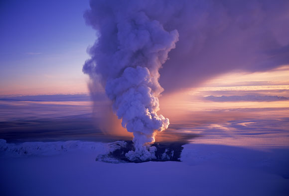
Drone Footage Of Icelandic Lava River
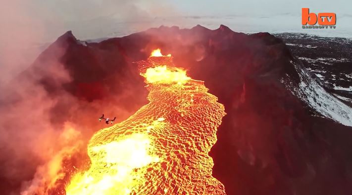
Lake Of Fire: Drone Footage Of Icelandic Lava River 1:46 mins A drone camera flies over a red hot lava lake in freezing cold Iceland and nearly melts in the process. The everchanging rivers of glowing lava shining through the gap between floating pieces of cooled crust are mesmerizing. The stunning footage was captured by US videographer Eric Cheng in February, 2015 and shows smoke and fire burning off the black marbled lava. Videographer / Director: Eric Cheng Producer: Mark Hodge, Chloe Browne Editor: Kyle Waters
Pillow Basalt and Palagonite – Lava Flowing into Water

Pillow basalt and palagonite are the result of lava flowing into water. We have a striking example in the Columbia River Gorge at the intersection of Hwy 30 and US 197 at the east end of The Dalles. This video gives a good idea of how these basalt pillows form and what they look like.