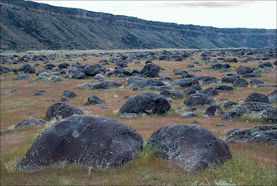
Celebration Park – Home of Melon Gravel
17,000 years ago, a massive Ice Age lake – now called Lake Bonneville – filled a large portion of present-day Utah. As temperatures changed, the influx of ice melt caused the lake level to rise. In addition, the Bear River, once a tributary of the Snake, was diverted by volcanic activity back into Lake Bonneville. These factors ultimately led to the breaching of a sedimentary rock dam at Red Rocks Pass, Idaho. There was only one ice-age Bonneville Flood because Lake Bonneville broke through a rock dam, unlike the Missoula Floods whose glacial ice dam repeatedly dammed Glacial Lake Missoula, then broke and rebuilt. 1,100 cubic miles of Lake Bonneville water rushed through the Snake River Canyon, and it took only six weeks for Lake Bonneville to empty the equivalent volume of modern-day Lake Michigan. The Great Salt Lake we know today is a remnant of Lake Bonneville, but at one tenth the size, it is a mere puddle compared to what the lake used to be. The power of this catastrophic flood widened canyons as the force of the water pulled huge chunks of basalt off the cliffs and tumbled them around, smoothing their jagged edges along the way. As the canyon width narrowed, the force and velocity of the flood increased. Wherever the canyons widened, the flood lost force and velocity, the waters slowed and began dropping its bedload – in this case, giant tumbled basalt boulders instead of your typical river gravel. These flood-rounded boulders, named melon gravel due to their distinct shape, are scattered over vast areas of land. The rocks’ unique outlines and smooth surfaces caught the eye of Native American tribes in the area, who have used them as canvases for petroglyphs for thousands of years. Visitors can see the medium sized flood deposits just outside the visitor center, or hike upriver to see gigantic melon gravel the size of heavy-duty trucks. Celebration Park is located in the Snake River Canyon, approximately 23 miles south of Nampa, Idaho. It is home to an enormous melon gravel field deposited by the Bonneville Flood.
Moses Coulee: An Ice Age Enigma

Washington state is famous for its dramatic landscapes, many carved by the immense power of the Ice Age Floods. We know the stories of the Grand Coulee, Palouse Canyon, and the Potholes. But tucked away in north-central Washington, cutting a path from northeast to southwest across the Okanagan Plateau, lies Moses Coulee – perhaps the most mysterious of them all. Unlike its famous cousins, Moses Coulee doesn’t quite fit the standard narrative. Its head seemingly emerges from beneath the Wisconsin Withrow Moraine, and its very formation presents a fascinating puzzle for geologists. Flood Theories and Questions: An Enigma The Grand Coulees (Upper and Lower) are widely believed to have been carved by the spectacular Missoula Floods. These colossal deluges were unleashed when the Okanagan Lobe of the Cordilleran Ice Sheet blocked the Columbia River, redirecting massive amounts of water southward. For Moses Coulee, it’s not so clear-cut. While cataract retreat due to massive floodwaters is generally assumed, most theories suggest the Okanagan Lobe effectively blocked the Missoula Floods from entering Moses Coulee. So, what carved this impressive landscape? Enter J. Harlan Bretz, the pioneering geologist who first championed the idea of colossal floods shaping the Pacific Northwest. Bretz observed a distinct wide bench within Moses Coulee, high above its floor. This led him to speculate about two distinct periods of glacial floods: An older, pre-Wisconsin “Spokane Flood” that initially carved Moses Coulee. A later Wisconsin period flood (what we now call the Missoula Floods) that deepened the coulee floor. Interestingly, current speculation suggests the Upper Grand Coulee might also owe its primary formation to these earlier “Spokane Floods,” with the Lower Grand Coulee being a product of the later Missoula Floods. It seems the story of Washington’s coulees is far more layered than once thought! Beyond Glacial Lakes: A Subglacial Hypothesis But wait, there’s another fascinating idea. Some investigators propose that Moses Coulee wasn’t carved by the well-known Missoula or Columbia glacial lake outbursts at all. Instead, they suggest outbreak floods from under the ice sheet itself. Joel Gombiner and Jerome Lesemann have explored this idea, suggesting that the immense pressure of the overlying ice lobe could have forced subglacial meltwater to flow uphill over topographic highs. This water would then have exited from under the ice, becoming the powerful floodwaters that sculpted Moses Coulee. Imagine that — floods erupting from beneath a massive glacier! Explore the Mystery Yourself The interplay between the Withrow Moraine and the unique features of Moses Coulee makes this a truly captivating area for exploration, especially for those intrigued by the raw power of ancient ice and water. To truly enhance your visit to this less-traveled gem, we highly recommend: Watching several of Nick Zentner’s insightful videos where he dives deep into these Moses Coulee questions. His engaging explanations bring the geology to life! Examining J. Harlan Bretz’s original field notes, meticulously organized in geolocated Google Maps by Glenn Cruickshank. It’s like stepping back in time with the pioneering geologist himself. Moses Coulee is more than just a landscape; it’s an ongoing geological debate etched into the earth. Are you ready to explore this remarkable natural mystery? AI-assisted article by Lloyd DeKay – Columbia River Gorge Chapter
Palouse Falls State Park

Palouse Falls State Park, dedicated in 1951, is a 94-acre park showcasing the dramatic Palouse Falls and its unique geological history. The park is a popular destination for viewing the falls, which were formed by Ice Age floods and are a key part of the Ice Age Floods National Geological Trail. The falls were designated as Washington’s state official waterfall in 2014, thanks to the advocacy of schoolchildren from Washtucna. Palouse Falls is one of four of the last remaining year-round waterfalls on the Palouse River that once stood in the path of the ice age floods. It is rich in both geological and human history. The native Palouse Indians called it “Aput Aput” meaning “falling water.” They believed that it was created by the Great Spirit because of his displeasure with the wicked Indians who lived further upstream. This obstacle was a barrier that allowed the salmon to travel no further. Sam Fisher, a Palouse Indian, also tells the story of how four giant brothers and their giant sister used oil from beaver tails to keep their hair shiny. Needing more oil, they searched for the giant beaver and fought with him. All four falls on the river were made when the beaver slapped his tail. At the last battle at Palouse Falls, the beaver struck his tail one last time creating the falls and the bowl it falls into. The vertical cracks in the basalt were made by the claws of the beaver. Palouse Falls has made a powerful impression on all who have visited. For example, one of the fall’s earliest visitors, Laurence L. Dodd in 1867, described the site he saw this way: “just before descending the Snake River hill your eye rests on the grateful green bottom of the Palouse with its clear and pure waters, flowing into the turbid Snake and after ascending the Snake River hill to the northward and eastward, the eye sweeps over a vast extent of country rarely surpassed in rugged desolation and wildness.…” Dodd was accompanied by a few local citizens from Starbuck on horseback to witness the scene he described. Early access to the falls was either by train (many passenger trains would stop here for their passengers to look at the falls) or by coming in from the east side. Robert E. Strahorn, who built the railroad up the Palouse Canyon had the original idea of making Palouse Falls a State Park. But it was not until years later that Washtucna area resident and president of the Washtucna Community Service Club John H. Baumann really pushed the idea. In 1945, Palouse Falls State Park was created. It was dedicated on June 3rd, 1951. The 299 acres that make up the entirety of this vast park were donated by The Baker-Boyer National Bank of Walla Walla, J.M. McGregor of the McGregor Land and Livestock Company of Hooper, and Mrs. Agnes Sells, a resident of Washtucna. Palouse Falls State Park is located off Highway 261, which branches off Highway 260 out of Washtucna. The most popular season for visiting is in the spring when the river is at its highest from winter snow melt. However, each season has its own story to tell as these pictures show. Article by Lloyd Stoess, President IAFI Palouse Falls Chapter
Explore Lake Roosevelt National Recreation Area
The Lake Roosevelt National Recreation Area serves as a striking landmark that narrates a dramatic geological history shaped by colossal natural forces. Greatly influenced by the Missoula Floods, this area, part of the Ice Age Floods National Geologic Trail, reveals not only stunning landscapes but also insights into the Earth’s geological story. Understanding this region offers a glimpse into the powerful events that occurred between 13,500 and 18,500 years ago, as well as the enduring environmental significance of these features. Lake Roosevelt and Grand Coulee Dam Lake Roosevelt, created by the Grand Coulee Dam in the 1930s, serves multiple purposes: from water storage and hydroelectric power generation to recreation and wildlife preservation. The lake provides a crucial habitat for various species and supports a vibrant ecosystem and is home to a range of fish species, including walleye, rainbow trout, and Kokanee salmon. The surrounding lands offer habitats for birds and other wildlife, contributing to ecological balance. With over 400 miles of scenic shoreline, the 150 mile long goes from Grand Coulee nearly to the Canadian board and is a haven for outdoor enthusiasts. The lake offers expansive waters perfect for various forms of boating. Anglers can enjoy abundant fishing opportunities year-round. 32 different campgrounds such as Spring Canyon close to Grand Coulee, WA offer numerous places to extend your overnight stays with these stunning landscapes. Historical Heritage The Lake Roosevelt area holds historical significance for the Confederated Tribes of the Colville Reservation and the Spokane Tribe of Indians, highlighting the intertwined relationship between Native heritage and the natural landscape. The National Park Service (NPS) supports Bureau of Reclamation management of Bakes Lake, Coulee Dam, and Lake Roosevelt. NPS works with Washington State Parks throughout the Grand Coulee Corridor and along with the Tribes and Washington Department of Natural Resources, oversees recreation on the water and lands of Lake Roosevelt NRA. Our collective efforts work to ensure that these natural treasures are preserved for future generations. Visitors to the area can engage with a variety of programs and informational resources that enhance their understanding and respect for the environment. Power in Nature The Grand Coulee and Lake Roosevelt National Recreation Area stand as remarkable examples of nature’s power and the intricate tapestry of geological history. From the cataclysmic Missoula Floods that sculpted the landscape to the thriving ecosystems supported by Lake Roosevelt, this region offers an unparalleled opportunity for exploration and discovery. Whether you are an avid hiker, a passionate angler, or a curious geology enthusiast, this area provides not only recreational activities but also a deeper connection to the Earth’s history. As we delve into the breathtaking scenery and rich cultural heritage of this national recreation area, we are reminded of the dynamic forces that shape our world. The Grand Coulee and Lake Roosevelt invite each visitor to engage with the past while understanding the importance of stewardship for future generations. This stunning landscape not only captivates the eye; it expands our knowledge of nature and our place within Ice Age Floods National Geologic Trail.
Coyote Canyon Mammoth Dig

The Coyote Canyon Mammoth Dig is an active paleontological excavation site in the Horse Heaven Hills near Kennewick, Washington. It’s a significant project that sheds light on the history of the Ice Age floods in the Tri-Cities area. The dig focuses on the unearthed remains of a Columbian mammoth that lived approximately 17,500 years ago. The mammoth’s carcass was buried in Touchet beds, a geological formation laid down by ancient floods. The site sits at an elevation of 1040 feet above sea level, which is considerably higher than the current elevation of the Columbia River, which is only 350 feet above sea level about 7 miles north. Scientists estimate that Lake Lewis, a massive glacial lake that existed during the Ice Age, reached a maximum surface elevation of over 1200 feet above sea level at the time the mammoth perished. This substantial difference in elevation hints at the immense power of the Ice Age floods that swept across the region. Another fascinating aspect of the Coyote Canyon Mammoth Dig is the discovery of a vast pile of erratic rocks. Initially thought to be a small cluster, the collection of these displaced rocks has grown to extend into several adjacent dig units. A dig unit, for those unfamiliar with archaeological and paleontological fieldwork, is a standardized square measuring 2 meters by 2 meters that archaeologists and paleontologists use to meticulously excavate and collect data. The MCBones Research Center, a non-profit organization, spearheads the Coyote Canyon Mammoth Dig. They offer educational tours for schools and other groups, providing a firsthand look at this significant paleontological excavation. These tours are a great opportunity to learn more about the Ice Age floods, mammoths, and the meticulous work of paleontologists. For more information about the Coyote Canyon Mammoth Dig, including details about tours, visit the MCBones Research Center website at www.mcbones.org.
Exploring Another Montana Flood
One of Montana’s other floods has been tickling the curiosity of some of our members.. This grew into a desire to plan a trip over to the upper Missouri River to see the channels from the diversion damming and outburst of Glacial Lake Great Falls. Thus, a reconnaissance was planned for 4 people. As the word got out everyone wanted to go and we wound with 14 souls on a loosely planned ‘let’s go over and see what we can find’ trip. The map below portrays Lake Great Falls when the Keewatin lobe of the Laurentide Continental Ice pushed the Missouri River out of its banks, pushing it south to the ice margin until the ice sealed off on the Bears Paw Mountains, then rapidly snaked off a sub lobe that sealed off on the Highwood Mountains. The lake began to fill to about 600 feet deep over Great Falls. It burst catastrophically at least once, creating the mile wide 500-foot deep Shonkin Sag (AKA Big Sag). This history appears to be a little more complicated than that as we turned up places where the last flood cut previous flood gravels. MBMG Special Publication 122: Geology of Montana, vol. 1: Geologic History by IAFI member DR Larry Smith is an excellent read for the details. This is a flood channel in soft rock (Cretaceous shale and sands). The lakes along the flood channels are endorheic (allows no outflow to other, external bodies of water or groundwater) so equilibrate by evaporation and are salty like the sea. The presence of these is a major clue the swale or drainage they are in is a flood channel. This is a flood channel in Shonkinite, a peculiar, dark igneous rock that would be basalt if it were not greatly enriched in potassium. Importantly it forms the columnar jointing common in basalt making it subject to plucking and the formation of retreat cataracts and geometry like the Washinton scablands. Note the column size. These are 5 to 10 feet in diameter and weigh many tens of tons but still the high surface area makes them subject to plucking if you have enough water moving quickly. We extracted a piece of Shonkinite gravel with blebs of white felspathoid syenite (like feldspar but having a different structure and much lower silica content) exsolving from Shonkinite magma like oil from water in salad dressing We stayed at Fort Benton, the historic steamship terminus on the Missouri river. Much of this is on private land and the landowner graciously allowed access to our group after being forced to close it due to trash and bad behavior. Lynne Dickman was the persistent silver tongued devil that made this happen. In all this was a very interesting reconnaissance of one of the other Montana floods. Article by Jim Shelden, President, Glacial Lake Missoula Chapter of Ice Age Floods Institute
Hike to Large Erratics in Gingko Petrified Forest State Park

In the approximate center of the state of Washington is the Gingko Petrified Forest State Park. And within the park is a trail, unnamed, which offers opportunities to view evidence of the terrific capabilities of the Ice Age Floods to transport huge boulders and leave huge deposits of rock material. The trail is off I-90 at exit 136 to the town of Vantage. After exiting the freeway travel north through Vantage for almost a quarter mile and turn right onto Recreation Dr. There is a sign to “Rocky Coulee Recreation Area.” It’s the old Highway 10 leading down to Lake Wanapum. This 0.3 mile section of road from the turn is bisecting the western margin of an eddy flood bar. The bar is about 0.75 mi in length and 0.25 mi in width. It extends down to the recreation area. At the end of this 0.3 mile section of road is the trailhead on your left. Parking is available here. A Discover Pass is required. The road continues another quarter mile to the Rocky Coulee Recreation Area at which restroom facilities are available. You could also park there. The trail starts along a slope above the Rocky Coulee. The bedrock here is all dark colored basalt. But deposited intermittently on the ground are light colored granitic rocks. Because they are not from this bedrock and are of a different composition than the basalt they are termed erratic. Where did they come from and how did they get here? That is the story of this hike. The last outburst floods from Glacial Lake Missoula are thought to have happened about 15,000 years ago. Huge chunks of ice, icebergs, broke away and carried whatever rocky material they had impounded during years of emplacement. The icebergs likely came from the Cordilleran Icesheet as it failed. This material was often granitic boulders and cobbles. Erratics here might have come from Rocky Mountain “Belt” bedrock or from glacial ice transporting Columbia-Okanogan valley bedrock and alluvium. When the flood waters made their way to this location, some 200 miles from their origin near Pend Oreille, they encountered some constrictions in the terrain which slowed their progress. The most significant constriction affecting this area was Wallula Gap, 70 miles south. It was less than 2 miles in width. That sounds like a wide gap but it was enough to prevent free flowing of these huge floods. Another, but less significant one, was Sentinel Gap, 10 miles to the south. Upon the waters slowing, eddies formed and the icebergs got caught up in those. The temporarily impounded water backed up onto these slopes. This resultant body of water has been named Glacial Lake Lewis. Inevitably some of the bergs became grounded on the slopes in the area. The highest erratic here is at 1,263 ft. The maximum water depth was about 800 ft. That’s about 700 ft above the existing water surface of Lake Wanapum reservoir. In the adjacent Schnebly Coulee erratics go up 3.5 miles. It’s estimated Lake Lewis existed and then drained within a few days, probably no more than a week. Upon the water finally receding through the gaps, with much less energy than upon arriving, the icebergs were left behind. Over time the bergs melted leaving behind their loads. These slopes are littered with hundreds of erratics. As you walk you can spot them along the trail. Most of them are small to moderate in size: less than 3ft². About a quarter of a mile into the hike the road starts taking a 90° right turn. As you round that turn you can see that Rocky Coulee below you takes a sharp turn to the south before again traversing to the east. It is quite possible the slope on which we are standing, a landslide, blocked the coulee and constricted that tributary’s water flow. As the water rose high enough to overcome the barrier it found a newer path to the south of its original course. We’ll see more evidence of the landslide up the trail. In another quarter mile, about half way to our destination there is a group of erratics on the right of the trail. There is more than one within a 3 foot radius so that makes it a cluster. But with fewer than 10 rocks in a 30 foot transect and the ground surface not greater than 3 feet higher than the surrounding terrain this is defined as a Low Density Erratic Cluster. This is a definition derived by a Central Washington University Masters student, Ryan Karlson in 2006. It incorporates a definition given by Bruce Bjornstad. At this same location you can look to the north and see a head scarp from a translational landslide. This whole hike is on a landslide. Looking to the east you can see hummocky terrain. So, there are 3 signs of landslide on this hike: head scarp, hummocky terrain, and the irregular tributary channel seen earlier. The soil here is very thin and nutrient poor: lithosol. It forms from weathered basalt, windblown loess, and volcanic ash. (You can still find ash from the 1980 Mt St. Helens eruption). It mainly supports a few species of sagebrush and bunchgrass along with seasonal wild flowers. Among the fauna found here are deer mice and ground squirrels. There are abundant Elk droppings you will see when leaving the trail to reach the destination erratic. I have seen a video of an Elk herd I would estimate was well over a hundred, perhaps two or three hundred running across nearby terrain. It was incredible! Traveling up the trail another quarter of a mile you can see the destination erratic off to the left on the trail. It will take about a quarter of a mile walk off the trail to get to it. This erratic is the single largest one in the park area at 85 ft². It’s 10 feet long and 8.5 feet high. It lies in a High Density Erratic Cluster, so
Moses Coulee: Unveiling the Mystery of a Colossal Ice Age Scar
Moses Coulee, a Washington state wonder, has puzzled geologists for over a century. This massive canyon, carved into solid basalt, stands as a testament to some powerful force. The culprit? The Ice Age Floods, a series of catastrophic deluges that reshaped the landscape. If you’ve ever visited, or even just passed through Moses Coulee, you may not have been aware that this awe-inspiring coulee has been an Ice Age Floods conundrum since the time geologist J Harlen Bretz first noted it in 1922. The problem? Moses Coulee doesn’t quite fit the picture. As Bretz described it, “The head of Moses Coulee is just north of Grimes Lake. It is an abrupt termination, walled by 100 foot cliffs, identical with the features of channeled scabland which are called abandoned cataracts.” The head of the coulee ends abruptly, lacking any clear connection to the known flood paths. Theorists proposed a missing link, a path obliterated by the Okanagan Ice Lobe, but no evidence of such a grand passage has ever been found. The mystery has persisted and become more enigmatic as Ice Age Floods research has flourished over the years: what colossal force carved this immense coulee? A new study by Gombiner and Lesemann (Geology, 2024) offers a radical new hypothesis. They propose a surprising source for flood waters: meltwater trapped beneath the massive Okanagan Ice Lobe glacier. Imagine the giant Okanagan ice sheet pressing down on the Waterville Plateau. Meltwater pooled in valleys beneath the ice, trapped and pressurized. This water, according to the theory, found a surprising escape route. Flowing through a network of hidden channels, it carved its way across intervening ridges and valleys, eventually funneling into Moses Coulee. This “tunnel channel network,” as the researchers describe it, explains the unusual path of the water. The channels themselves, carved in basalt, climb slopes and defy normal drainage patterns. These features, along with glacial landforms like eskers, suggest a watery escape route beneath the ice sheet. The study doesn’t rule out the role of traditional Ice Age Floods. Water from massive glacial lakes might have also contributed to Moses Coulee’s formation by flowing along the eastern edge of the glacier. This new hypothesis could be a game-changer. It suggests a hidden world of pressurized meltwater sculpting the landscape beneath the ice. While the debate continues, one thing is certain: Moses Coulee remains a captivating enigma, a place where the power of water and ice continues to unfold its secrets.
Ice Age Floods Around the World

(03 December 2023) The last ice age of Earth involved immense floods with peak flows comparable to those of ocean currents. About 40 examples are now known from Asia, Europe, North America, South America, and Iceland. These mega-floods generated major landscape changes and huge fluxes of freshwater to the world oceans, resulting in global climatic change. The profound consequences of this flooding for Earth’s inhabitants may have even inspired many oral traditions of world-wide inundation. Vic Baker’s interest in the ice-age flood landscapes began in the 1950s when he was living in Bothell, Washington. His Ph.D. research on the scablands, completed in 1971, partly advised by J Harlen Bretz. A former President of The Geological Society of America, his publications include 20 books and more than 450 geology articles. He has appeared internationally in more than a dozen television documentaries dealing with ancient mega flooding on Earth and Mars.
Recording of Erratics’ October 10 program, “Reading the Okanogan Lobe Glacial Landscape”

Because of problems with the Zoom broadcast of the Erratics’ October 10th program, Ralph Dawes graciously recorded for us his talk, “Glaciated landscapes that formed beneath the Okanogan Lobe of the Cordilleran Ice Sheet,” so that we could all enjoy it. Or re-enjoy it. He talks through the slide show, with all the illustrations showing up clear and supportive. The video software lets you view the slides full size, or the slides plus a table of contents at the side, if you click in the right places.You can watch at 1.5x speed by clicking on the gear icon lower right, if you want to hurry along to topics of interest (that appear in the side bar). You can also pause the video to study individual figures. The recording is hosted on a server Wenatchee Valley College provides for faculty to store teaching videos that are retained for the foreseeable future. The video is set to be open to anybody, no password needed. https://wvc.hosted.panopto.com/Panopto/Pages/Viewer.aspx?id=5105f23e-e869-4909-b7b8-b0b10002f143 Here is also a link to the YouTube version: https://youtu.be/1A2hkmxTDdo