Ice Age Floods Around the World

(03 December 2023) The last ice age of Earth involved immense floods with peak flows comparable to those of ocean currents. About 40 examples are now known from Asia, Europe, North America, South America, and Iceland. These mega-floods generated major landscape changes and huge fluxes of freshwater to the world oceans, resulting in global climatic change. The profound consequences of this flooding for Earth’s inhabitants may have even inspired many oral traditions of world-wide inundation. Vic Baker’s interest in the ice-age flood landscapes began in the 1950s when he was living in Bothell, Washington. His Ph.D. research on the scablands, completed in 1971, partly advised by J Harlen Bretz. A former President of The Geological Society of America, his publications include 20 books and more than 450 geology articles. He has appeared internationally in more than a dozen television documentaries dealing with ancient mega flooding on Earth and Mars.
Ice Age Floods throughout the Quaternary – Don’t forget the older ones!

(12 October 2023) Most of the time when we discuss the Ice Age Floods, we are talking about the Missoula Floods which happened from 18,000-15,000 calendar years ago. Our research shows that there are many sites of much older flood deposits (they have calcite horizons in them) that show that megafloods happened throughout the Quaternary. In my book, I call them Ancient Cataclysmic Floods because we do not know where the water came from. Scott Burns is a professor emeritus of geology at Portland State University where he is starting his 34th year. He has been teaching actually for 54 years with previous positions in Switzerland, Colorado, Washington, Louisiana, and New Zealand before returning to his hometown of Portland in 1990. His specialties in geology are: Quaternary Geology (Missoula Floods). engineering geology and geomorphology (landslides), environmental geology (radon, heavy metals in soils) and soils (terroir of wine). He has been a member of the Ice Age Flood Institute since it started.
Puget Sound Area has a Glacial Story to Tell

Although the Seattle region was not impacted by the large floods from Glacial Lake Missoula, Glacial Lake Columbia, or other glacial lakes east of the Cascades, the Puget Sound region has its own glacial story to tell. It’s interesting that J Harlen Bretz, who first imagined that a massive flood produced the Floods features in the Columbia Plateau, also did his PhD on “Glaciation of the Puget Sound Region”. The Puget Lobe of the Cordilleran Ice Sheet advanced and retreated over the Puget Lowland at least seven times during the Quaternary Ice Age. In the process, it left behind rocks, sediments, and other geologic clues that tell the intriguing story of ice, proglacial lakes, and flooding across the landscape near Seattle. Snoqualmie Falls, near North Bend, WA east of Seattle is a popular tourist destination. At the falls, the Snoqualmie River plunges 82m over a wall of volcanic rock. Few tourists, however, understand the role that the Puget Lobe of the Cordilleran Ice Sheet played in the formation of the falls. Prior to glaciation, Snoqualmie Falls did not exist, instead, the river flowed in an incised channel east of the current falls. As the Puget lobe advanced into the Puget Lowland about 18,700 years ago, the glacier’s eastern margin blocked drainage from rivers flowing out of the Cascades, including the Snoqualmie River. A large glacial lake known as Glacial Lake Snoqualmie formed over North Bend and over the Snoqualmie Valley. Tokul Creek, one of the tributaries, formed a thick underwater delta in the lake as its sediments poured into Glacial Lake Snoqualmie. When the Puget Lobe retreated, Glacial Lake Snoqualmie drained to the west and the Snoqualmie river attempted to follow its original channel. However, the original course of the river was blocked by the delta deposits from Tokul Creek and the river was forced to flow over a narrow band of rocks from an eroded volcano further to the south. Snoqualmie Falls flows over this volcanic rock today, but since the last glacial maximum, cataract recession has rapidly eroded the rocks back to a 200m wide band of andesite and volcanic breccia. Behind the thin volcanics is a thick layer of soft alluvium. At the current rate of recession, the Snoqualmie River will erode through the volcanic rock in about 7,200 years. When that happens, the river will hit the alluvium and the falls will quickly devolve into a series of rapids. You might want to hurry to see the falls before they disappear! Other glacial lakes were formed at the southern margin of the Puget Lobe near modern day Seattle. As the Puget Lobe advanced south, it dammed rivers and streams that were flowing north. In places, the bluffs surrounding modern Puget Sound hold a record of the advancing glacier and the pro-glacial lakes backed up by the ice front. One good place to view these sediments is from the beach at Discovery Park in Seattle. A layer cake of sedimentary units records the pre-glacial river system, the advance of the ice, the damming of the proglacial lakes, and the retreat of the ice sheet to the north. At the base of the cliffs the Olympia Formation records the pre-glacial environment of north-flowing rivers and streams. The Lawton Clay layer indicates the formation of proglacial lakes. The Esperance sand represents a period of glacial retreat. The glacier that repeatedly covered the Puget Lowland left behind multiple geologic clues for us to interpret. The Puget Lobe of IAFI welcomes members from other chapters to join us as we explore the glacial history of the Puget Lowland.
Grand Coulee – Geology of the Entire 50 miles

The 50-mile-long Grand Coulee should be on everyone’s bucket list for a “must see” feature. The immense power of the forces that created the Coulee are apparent to those who read the evidence recorded in its rocks and landforms. How did the Coulee form? Why did it form here? What do features like Steamboat Rock, Northrup Canyon, Dry Falls, and the Ephrata Fan tell us about the geological forces that created the Grand Coulee? This presentation will be made May 1, 2023 beginning at 7:00 pm, via Zoom _ https://us02web.zoom.us/j/82985244730 Dr Gene Kiver is professor Emeritus of Geology, Eastern Washington University. He studied alpine glaciation in the Rocky Mountains before moving to Washington State and discovering that J Harlen Bretz had correctly interpreted the bizarre landforms of the Channeled Scabland. Gene taught geology at Eastern Washington University for 34 years. He co-authored “On the Trail of Ice Age Floods” with Bruce Bjornstad that describes the flood history of the northern flood routes of the Missoula Floods. In addition, he authored/co-authored the book “Washington Rocks” and several other books. One item in particular is “Tour Guide Interstate 90 East Tour: Seattle to Spokane” (2007). A CD narration of the people and places as defined by the title. Of the 51 tracks, Dr. Kiver narrates 4 on the Geology of I-90. The Chapter webmaster has ordered it and will update this post after listening to the recording. I bring this up as many of our lectures are about or by people who explored or are exploring the geography of the Ice Age Floods. Look on Amazon under “Eugene Kiver” for this and other books.
Puget Lobe Chapter Origins – A Brief History
The Puget Lobe Chapter of the Ice Age Floods Institute had its origins in Wenatchee in 2007 during the Institute’s annual field trip. While riding in the tour bus, long-time member Mark Sundquist informally suggested to some nearby Seattle area members the possibility of starting our own Seattle Chapter. The idea was met with an enthusiastic response. Some members had been making the long drive over to Wenatchee from Seattle to attend meetings. There was also a recognition the Seattle had a tremendous amount of ice age geology of its own to offer. Later during the field trip Mark mentioned the conversation to former Institute president Dale Middleton. Dale liked the idea and thought it was worth pursuing. During the fall of 2007 Dale and Mark had a series of meetings to lay the groundwork for establishing a Seattle chapter. Dale’s years of experience as Institute president, familiarity with Institute business, and attention to detail were invaluable. He also had an encyclopedic knowledge of the ice age floods, a love for geology, and great dedication to the work of the Institute. He had a list of greater Seattle area contacts from his work as Institute president and this list formed the genesis of the Seattle chapter’s mailing list. On December 3, 2007, a well-attended organizational meeting of the Seattle chapter was held at the Lynnwood library. Chapter officers were elected with Mark serving as president and Dale serving as vice-president. By-laws were adopted and the name Puget Lobe was selected. By a strange coincidence, during this time the Chehalis River, the ice age outlet for the Puget Lobe drainage, experienced record flooding. In January of 2008 the first regular meeting of the Puget Lobe Chapter was held at the Shoreline library. The meeting was again well-attended with Dale warmly greeting the arriving attendees many of whom he knew from his previous work on behalf of the Institute. Gene Kiver gave a program on the ice age floods. In July of 2008 the Puget Lobe’s first field trip took place. It included presentations on the recessional phases of the Puget Lobe and the Carbon River Glacial Outburst Flood, and tours of the Mima Mounds and Thurston County’s Glacial Heritage Preserve. In the fall of 2008 the Senior Center in Edmonds was procured as a regular meeting place for the chapter. With some members arriving from northern Puget Sound, some from southern Puget Sound, and some by ferry from across Puget Sound the central location adjacent to the ferry dock was convenient. Mark served several terms as president followed by several terms by Dale.
Scholars Trek on the Ice Age Floods Trail

Ice Age Floods Fourth Grade Curriculum Development One of the missions of the Ice Age Floods Institute is to educate young people about the Floods and the influence of the Floods on their lives today. The IAFI Educational Outreach Committee has contracted with the curriculum design firm The Inspired Classroom to produce engaging lesson materials to excite fourth-grade students from across the Northwest about the Ice Age Floods. The curriculum will contain video footage narrated by experts and lesson plans for use by fourth grade teachers in Montana, Idaho, Washington and Oregon. The story, entitled “Scholars Trek on the Ice Age Floods Trail,” will begin with a flyover video of the trail, including Glacial Lake Missoula, the Clark Fork Ice Dam, the Rathdrum Prairie, Spokane Falls, the Channeled Scabland, Lake Lewis, the Columbia River Gorge, Lake Allison, and the deposition of the eroded sediment on the continental shelf at the mouth of the Columbia River. Along the route, students will be introduced to the ways in which the Floods influence society today, including the influence of the Floods on the Spokane Aquifer and on railroad and highway routes across the Pacific Northwest. Funding for the project will come from grants, the IAFI, and from private benefactors. The continued support of IAFI members through membership dues and donations helps fund projects like this. The Education Committee is made up from a sampling of IAFI Board Members and Chapter Presidents from each state: Jim Shelden (Glacial Lake Missoula); Tony Lewis (Coeur du Deluge); Melanie Bell and Consuelo Larrabee (Cheney-Spokane); Gary Kleinknect (Lake Lewis) and Dale Lehman (Puget Lobe.) In the future, the Education Committee plans to work on curriculum materials for middle and high school students. By Dale Lehman, 04/14/2022
Puget Lobe Chapter Field Trips

The Puget Lobe Chapter sponsored field trips enable IAFI members and the public to join in these educational opportunities. The Puget Sound area is remarkable for Cordilleran Continental Ice Sheets that issued forth from British Columbia and abrading and deforming the area between the Cascades and Olympic Mountains from the area to the Pacific Ocean “north” of the Olympics and there called the Juan de Fuca Lobe. “North” is a relative term, as the Last Glacial Maximum (LGM) was a condition of the ice sheet size at any given time. For example, the Double Bluff Glaciation LGM (190 Kya – 130Kya {T2*}) extended to ≅Tenino, while the Puyallup Glaciation (80-59Kya) LGM only extended ≅ Bremerton. The Fraser Glaciation (30Kya – 15Kya {T1 at 11Kya}) LGM terminated just below Olympia. We also had Alpine Glaciation in the Cascade and Olympic Mountains. For example, prior to the Fraser ice sheet flowing into the Puget trough, the alpine glaciers had advanced and receded from the same area (LGM 22Kya). (Note: T2 and T1 are Termination Points) The Puget Sound area was isolated by the Cascades Range from the large number of ice sheet lobes found in Eastern Washington, Idaho, and Montana, Similarly, we were isolated from the Missoula Floods and the effects of those floods which rampaged down the Columbia River and turned west at Longview – a mere 20-30 miles south of the Puget Lobe LGM. Yes, all the ice lobes in our area were called “Puget Lobe” except where the Puget Lobe couldn’t get past the Olympics. Forced to take a westerly turn towards the Pacific Ocean, that was called the Juan de Fuca Lobe. The first of our four Spring Field Trips: 1. Building Stone of Seattle, (Completed) 2. Ice Age geology of the Snoqualmie Valley, (full not accepting participants) 3. June 1-3: Frenchman Springs Coulee and the Ice Age Floods This trip is completed 4. June 30: The Advance and Retreat of the Cordilleran Ice Sheet Revealed at Discovery Park This trip is completed
Puget Lobe Chapter Lectures On-line

The Puget Lobe Chapter will post recordings of our presentations on YouTube. There are members of the Chapter who can’t make a presentation, but who would like to view our lectures after the fact.. Others may want to review portions of the presentation to answer questions. To accommodate our members, many of our presentations are recorded. The library of past Puget Lobe IAFI lectures is hosted on our YouTube channel, which can be accessed through the Puget Lobe IAFI YouTube Channel: https://www.youtube.com/channel/UCdIqmi3j3uwX2GKvXM1a_2g
Nick Zentner – More Geology Videos

Are you looking for new geology videos? Nick Zentner has done a long series live geology lectures from his home in Ellensburg and posted them online to his YouTube channel https://www.youtube.com/user/GeologyNick/videos He is now recording a series of “Nick on the Fly” virtual field trips and posting them on the same YouTube channel https://www.youtube.com/user/GeologyNick/videos Join Nick as he explores the geology of the Pacific NW and many other topics.
Use Social Distancing Time to Explore the Floods with Our Interactive Online Map
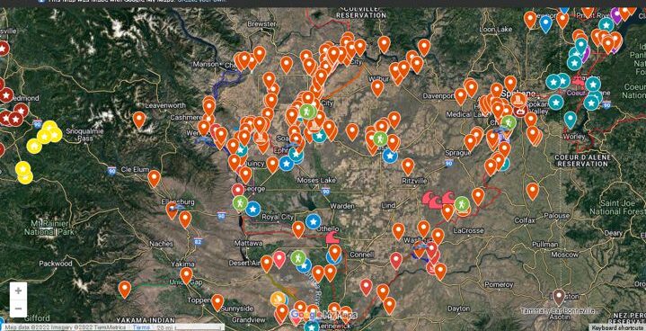
If you’ve ever tried to explore the Ice-Age Floods with a guidebook you’ll know how difficult and frustrating it can be to find and learn about the features in the area you’re visiting. Well, there’s now a solution to that problem; an interactive map that’s available wherever you have internet access. The map features over 300 points of interest throughout our 4-state area, with a description and images that slide out when you click on one of the markers. More features are being added all the time, and we’re planning to expand the map with features related to the Lake Bonneville Flood event that rampaged through the area during the time of the Ice-Age Floods. Since this is an internet-based map, it’s also easy to get driving directions to the site from wherever you are starting from. You can also easily build an informative field trip, exploring and learning about a number of other nearby features with just a few clicks of your mouse. We feel this may be the most useful field guide ever developed to explore ice-age Floods and glacial features throughout our 4-state region. AND it’s absolutely FREE! The only shortcomings we see are 1) the map requires internet access, which isn’t always available in far-flung areas of our region, and 2) we may not have every point-of-interest on the map (YET!). If we’re missing something you think is important we encourage you to submit your suggestion. We also appreciate any comments and/or corrections by email to Webmaster@IAFI.org. We sincerely hope you enjoy using this guide to poke around these fascinating ice-age features.