Celebrating the Life and Legacy of Dr. Gary Ford (1943 – 2026)

Members and the Board of Directors of the Ice Age Floods Institute (IAFI) remember fondly our long-time leader, mentor, and friend, Dr. Gary Ford, and deeply mourn his passing. Gary left us peacefully at his home on June 4, 2026 after living a full life of service, curiosity, and dedication. Born in Illinois on May 20, 1943, Gary lived it with an infectious curiosity in a journey defined by service and a profound connection to the earth. After serving in the United States Air Force, he channeled his love for the environment into a Ph.D. in Soil Conservation at Montana State University. He went on to spend a meaningful career protecting America’s most iconic landscapes as a park ranger in Yellowstone National Park and later with the U.S. Forest Service. When Gary “retired,” he brought his leadership and wealth of knowledge to the Ice Age Floods Institute, first as President of the Cheney-Spokane Chapter (2009–2012), then taking the helm as Institute President from 2012 to 2026. Gary tirelessly shared and fully believed that the grand, cataclysmic geological history of the Pacific Northwest belonged to everyone. As a leader, Gary was defined by his extraordinary openness, thoughtfulness, and exceptional people management skills. He possessed a rare ability to harness a diverse Board of Directors, skillfully guiding a wide range of perspectives and building bridges toward a unified, shared vision. He was always eager to welcome new members, champion fresh ideas, support grassroots chapters, and spark a shared sense of wonder in anyone who would listen. His leadership wasn’t rigid or about titles; it was about fostering an open, collaborative community united by curiosity. Gary’s quiet strength, warmth, and gentle spirit left an indelible mark on his family, colleagues, and the landscape he spent his life protecting. Beyond his geological pursuits, Gary was a devoted family man who loved sharing adventures, laughter, and a good story. He is survived by his beloved wife, Barbara Ford; his daughter and son-in-law, Flavia and Matt Hildebrant; his grandsons, Aspen and Dylan Bergland; his sister, Luann Ford; and his cousin, Anna Belle Alshire. He famously passed his love of Star Wars down to his grandsons and was always ready with a perfectly timed Yoda quote to put life into perspective: “Luminous beings are we, not this crude matter.” In keeping with Gary’s wishes, no formal celebration of life will be held. Instead, his family will scatter his ashes in a place that held a special, enduring meaning to him.
Missoula Floods Feature – A Site of Mammoth Proportions
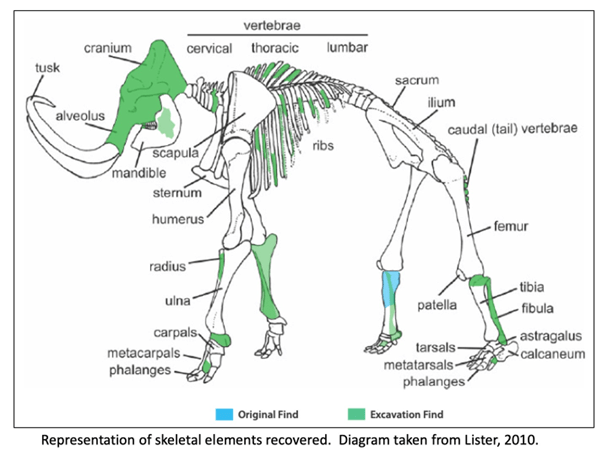
It has been well proven that the Missoula Floods greatly impacted central Washington and there are many examples of the magnitude of the floods, its reach, and dynamics. However, there is still debate on the number, size and timing and dating of these events. What is also less well known are some of the casualties of the floods. At least one feature is helping to tell the story of some of the last floods to grace the landscape. In 2015, a mammoth was discovered at Tonnemaker Hill Farm along the north edge of the Frenchman Hills in Grant County, Washington. Luke Tonnemaker was plowing up an alfalfa field when he made the discovery. Intensive study of the site was led by geologist George Last, paleontologist Bax Barton, local soil scientist and geologist Mark Amara, Gary Kleinknecht, education director, from the MCBONES Research Foundation, a volunteer excavation crew from MCBONES and the Tonnemaker family. The researchers coordinated with farm co-owners, Luke and his father, Kole Tonnemaker, and their wives Amanda and Sonia respectively, to professionally excavate, stabilize retrieved mammoth bones, identify as many bones as possible, and recreate the geology and history of the site. Mammoth remains are not that uncommon in Washington with several hundred animals discovered in the state, though fewer than 100 of those discoveries are located in eastern Washington. What is significant about this mammoth site is that it is one of the few finds that has received this much intensive study. Over 130 bones and bone fragments from a single Columbia mammoth were recovered with about 69 specimens identified. The animal was estimated to be between 25-30 years of age based on characteristics of its dentition, and it even lived with a damaged rib which had healed. George Last prepared diagram The presence of three distinct volcanic ash (tephra) layers and soil analyses suggests that at least four different Missoula flood event episodes are represented in the sediments beneath the mammoth bone bed. Dating of the site revealed that the animal post-dated identified Mount St Helens tephra eruptions that deposited ash in distinct horizons below the bones in water borne deposits. Dates associated with ash samples identified at WSU confirmed two of the layers correspond to Mount St. Helens S series while the topmost tephra shows some compositional variability but had similarities to the J or S series. Tephra ages ranged roughly from 14,000-16.000 years ago. Further dating through Utah State University was provided by optically stimulated luminescence (OSL) samples which gave dates ranging from 16-19,000 years ago. Since the bones are above the highest tephra and OSL sampling sites, the find is definitely younger than 16,000 years ago and was on the edge of one of last Pleistocene Missoula floods slack water lakes to cover this part of Washington. These conclusions were corroborated by analyzing the stratigraphy of the site and describing the soil which confirmed environments of deposition. Since the bones were above the aforementioned tephra layers and OSL sampling locations, and are at the interface of apparent windblown silts and Missoula floods slackwater deposits, it is still unclear how and when the animal died. However, the co-location of the mammoth remains with apparent ice-rafted erratic cobbles and boulders in fine-grained Missoula flood sediments, supports interpretation that the mammoth could have been carried in and left behind by a late breaking Missoula flood. Alternatively, it could have become mired in the mud along the shoreline and/or was killed by predators or even died in a subsequent drier period. Still the intensive studies to date have shown that this is an area with unique geologic history, one that is still unfolding. The Tonnemaker family has the recovered bones on display at their farm store and annually, including 2026, hold tours of the mammoth site during the Othello Sandhill Crane Festival held in March each year. There are a variety of papers, poster presentations and articles published or defended at meetings held by the Northwest Scientific Association and Geological Society of America, and a final report of findings between 2016-2024, with summaries highlighted, is available for viewing at the farm. Article by Mark Amara, Geologist, IAFI Lower Grand Coulee Chapter
Volunteers Help Shape the IAFI!

We’re reaching out to ask for your help. As we work toward our mission of promoting public awareness and education about the Ice Age Floods, our chapters have been facing a significant challenge: a shortage of active member volunteers willing to step into leadership roles or assist with essential chapter functions. Many of our current leaders are in their 70s and 80s, and the demands of their roles are becoming challenging. While our dedicated leaders works to maintain our organization’s momentum, we need support to ensure our continued growth and success. Your involvement will be crucial in helping to: Organize events: Assist with planning field trips, chapter functions, and speaker series. Provide administrative support: Help with recordkeeping, website updates, and newsletter contributions. Engage with the community: Connect with local schools and media outlets to spread awareness about our mission. Contribute fresh perspectives: Share your ideas and expertise to help us adapt to a changing world. Here are some ways you can get involved: Volunteer for events: Help plan and execute field trips, workshops, and conferences. Join a committee: Contribute to our leadership team and help make important decisions. Share your expertise: Offer your skills in areas like marketing, communications, or technology. By becoming more involved, you can: Strengthen your chapter: Contribute your time and skills to make your local chapter more vibrant and effective. Share your knowledge: Bring new ideas and contemporary skills to our organization. Support the organization: Help IAFI achieve its goals and become the foremost provider of Ice Age Floods information. No matter your level of experience or commitment, we welcome your participation. Whether you can volunteer a few hours a month or are interested in taking on a leadership role, your involvement will make a significant difference. The involvement of many will lighten the load on the few, and also bring a much-needed infusion of energy and fresh perspectives. We believe that by working together, we can strengthen our organization and better serve our mission of promoting public awareness and education about the Ice Age Floods. Your participation is essential. To get involved, please contact your local chapter through the IAFI.org website
Unearthing the Secrets of Spokane Valley: A Recap of the IAFI June Jamboree
This year’s IAFI June Jamboree delved into the fascinating geological history of Spokane Valley, contrasting it with the iconic Grand Coulee and Dry Falls, explored during last year’s Jubilee. Challenging the Landscape: Unlike the open spaces of Dry Falls, Spokane Valley presented a unique challenge – showcasing evidence of Ice Age Floods within an urban environment. Our chapter tackled this brilliantly, organizing hikes and car caravans departing from convenient public parks and commercial areas. Evening Explorations: The program’s highlights included captivating lectures. Professor Emeritus Dean Kiefer shed light on J Harlen Bretz’s Spokane associates, while renowned naturalist Jack Nesbit brought the story of the first Columbian Mammoth discovered near Latah Creek in the 1800s to life. Celebrating Success: The Jamboree culminated in a relaxed gathering at Mirabeau Meadows. Registrants, leaders, and participants exchanged insights and experiences, with a resounding appreciation for the chapter’s efforts. Comparisons were drawn, highlighting how our Spokane Valley exploration continued the excellence of the Puget Lobe’s outing at Dry Falls last year. A Delicious Finale: The grand finale was a catered Longhorn Barbecue overflowing with delicious food. Everyone left satisfied, with many even taking home doggie bags to savor the flavors afterward. Check out more images from the event in this Google Photo Album. Meet the Masterminds: Linda & Mike McCollum: This dynamic professor emerita and a research geologist duo co-led tours and car caravans, sharing their latest research on the Spokane area’s Ice Age Floods, and shaping the Jamboree’s theme. Michael Hamilton: A gifted geologist, Michael led hikes and the bus trip, encouraging questions and offering honest answers. Don Chadbourne & Chris Sheeran: Don, the chapter treasurer, managed logistics with expertise, while Chris, our media and registration guru, ensured a smooth experience. Melanie Bell Gibbs: A past president and national board member, Melanie oversaw participant check-in and badge distribution. Dick Jensen: Dick handled bus transportation and provided crucial support throughout the Jamboree. Jim Fox: The chapter vice president secured speakers and offered his assistance wherever needed. We also owe a great deal to the participant volunteers who proved invaluable in assisting us in all our efforts. Through the combined efforts of many the IAFI June Jamboree was a resounding success, fostering exploration, education, and a deeper appreciation for the Spokane Valley’s unique geological heritage. Being present with so much information and conversation among such extensive expertise was to witness the scientific process in action. Meeting people from other chapters was particularly nice, putting faces with names we know. We all learned a lot.
Scabland – The Movie, A Google Earth Odyssey

“Scabland” – the Movie, A Google Earth Odyssey “Scabland” is a media complement to CWU Professor Nick Zentner’s 2023-2024 A-Z YouTube geology series that re-treads the ice age floods and the work of Professor J Harlen Bretz and others. In this short animation, viewers virtually fly to a selection of locations visited by geologist Dr J Harlen Bretz, with quotes from his original field notes, geolocated in Google Earth and animated with Google Earth Studio. To see more of these locations, visit https://www.geology.cwu.edu/facstaff/nick/gBRETZ/ This video was done as an experiment/prototype by the authors, Glenn Cruickshank and Eric Larson, to showcase Google Earth, virtual special effects techniques, some of the spectacular landforms caused by the floods, the impacts of ice and water during the Last Glacial Maximum and the field locations of J Harlen Bretz. Eric Larson in Billings MT runs Shashin Studio, a VFX video production company (contact@shashin.studio). Google Earth Glenn is a retired photojournalist and consultant in Liberty Lake WA. Credits: Glenn Cruickshank Eric Larson Two Steps From Hell Made with Google Earth and Google Earth Studio. Thanks to The Families of J Harlen Bretz and Thomas Large, Nick Zentner, Glenn Cruickshank, Bruce Bjornstad, The Ice Age Floods Institute, and many others.
Othello Sandhill Crane Festival -March 24-26, 2023

The Othello Sandhill Crane Festival announced the 2023 theme as “Silver Anniversary, Celebrating Our Annual Visitors.” The 25 th annual festival will be held March 24-26, 2023 in Othello Washington. We are excited to be celebrating our 25th year! The festival celebration of the spring migration of the Sandhill cranes offers a variety of events for the whole family to enjoy and learn. The festival will be in the same locations as last year. The lectures will be held at the Othello Nazarene Church, 835 S 10 th Ave, Othello, WA. The Church is next door to McFarland Middle School where we will have the children’s art projects, the vendors, the photo booth, the Rotary breakfast, and the art contest. We will be utilizing both facilities. Food trucks will be available for lunches. Online registration opens on February 6, 2023. Visit the Othello Sandhill Crane Festival website for more information on the events at Website: othellosandhillcranefestival.org. Follow us for updates on Facebook: www.facebook.com/Othello-Sandhill-Crane-Festival Cathy Nowak will be one of the featured speakers on Saturday, March 25, at 7:30pm. Cathy will be speaking about Sandhill Crane nests and how experience matters, with both words and photos. Dr. Kaeli Swift will be the other featured speaker on Friday, March 24, at 7:30 pm. This lecture will require masks. Swift will explore commonly asked questions about crows, how crows have co-evolved with people, and what crows and other corvids can teach us about the nature of intelligence. Saturday, March 25, the lectures will cover cranes, birds, Ice Age Floods, the Drumheller Channel, and much more. We are planning tours by bus, bike, boat, car and self-directed, crane viewing tours will be back. Some tours will be set up over two weekends. The Children Activities Committee will have fun activities for kids such as binoculars made of toilet paper rolls to use for “birding” in the gym by finding pictures of various birds, origami folded crane mobiles, mask making and many other activities. We will again have the free photo booth to take your picture with a digitized Sandhill crane in the background to take home as a memento.
Nick Zentner – More Geology Videos

Are you looking for new geology videos? Nick Zentner has done a long series live geology lectures from his home in Ellensburg and posted them online to his YouTube channel https://www.youtube.com/user/GeologyNick/videos He is now recording a series of “Nick on the Fly” virtual field trips and posting them on the same YouTube channel https://www.youtube.com/user/GeologyNick/videos Join Nick as he explores the geology of the Pacific NW and many other topics.
Use Social Distancing Time to Explore the Floods with Our Interactive Online Map
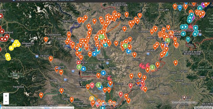
If you’ve ever tried to explore the Ice-Age Floods with a guidebook you’ll know how difficult and frustrating it can be to find and learn about the features in the area you’re visiting. Well, there’s now a solution to that problem; an interactive map that’s available wherever you have internet access. The map features over 300 points of interest throughout our 4-state area, with a description and images that slide out when you click on one of the markers. More features are being added all the time, and we’re planning to expand the map with features related to the Lake Bonneville Flood event that rampaged through the area during the time of the Ice-Age Floods. Since this is an internet-based map, it’s also easy to get driving directions to the site from wherever you are starting from. You can also easily build an informative field trip, exploring and learning about a number of other nearby features with just a few clicks of your mouse. We feel this may be the most useful field guide ever developed to explore ice-age Floods and glacial features throughout our 4-state region. AND it’s absolutely FREE! The only shortcomings we see are 1) the map requires internet access, which isn’t always available in far-flung areas of our region, and 2) we may not have every point-of-interest on the map (YET!). If we’re missing something you think is important we encourage you to submit your suggestion. We also appreciate any comments and/or corrections by email to Webmaster@IAFI.org. We sincerely hope you enjoy using this guide to poke around these fascinating ice-age features.
Explore the Ice Age Floods with 12 New IAFI Brochures

IAFI has compiled 12 brand-new, full-color brochures into a packaged set to help guide you in visiting spectacular ice-age features across all of our 11 Ice Age Floods chapter areas. With these brochures as your guides you can explore the paths of the Ice Age Floods from Montana through Idaho, central Washington and northern Oregon, and even delve into the many glacial features of northwest Washington. Click on any of the brochure covers below to see a full size printable PDF version (note: you’ll need to scale down to print on 8.5×11 letter size paper). Packets of all 12 full-size brochures are NOW available through the IAFI Store and at participating local outlets. Click a cover to open a PDF of any of the brochures below
Oral/Pictorial Video History of the Palouse Area
This 1/2-hour video begins with the Ice Age Floods impact on the Palouse area, then goes on with a fascinating oral and pictorial history of the area. The video was produced by Mortimore Productions for the Whitman County Library with materials and information provided by a bevy of contributors, including several IAFI members. This is a must view if you’re planning to travel to the Palouse Falls Chapter. In this stunning video you’ll learn about the Floods impact, early settlers, mule trains, sheep herders, and so much more that will make the event ever more personal and relevant. Whitman County Library – Ice Age v06 from Mortimore Productions on Vimeo.