Scholars Trek on the Ice Age Floods Trail

Ice Age Floods Fourth Grade Curriculum Development One of the missions of the Ice Age Floods Institute is to educate young people about the Floods and the influence of the Floods on their lives today. The IAFI Educational Outreach Committee has contracted with the curriculum design firm The Inspired Classroom to produce engaging lesson materials to excite fourth-grade students from across the Northwest about the Ice Age Floods. The curriculum will contain video footage narrated by experts and lesson plans for use by fourth grade teachers in Montana, Idaho, Washington and Oregon. The story, entitled “Scholars Trek on the Ice Age Floods Trail,” will begin with a flyover video of the trail, including Glacial Lake Missoula, the Clark Fork Ice Dam, the Rathdrum Prairie, Spokane Falls, the Channeled Scabland, Lake Lewis, the Columbia River Gorge, Lake Allison, and the deposition of the eroded sediment on the continental shelf at the mouth of the Columbia River. Along the route, students will be introduced to the ways in which the Floods influence society today, including the influence of the Floods on the Spokane Aquifer and on railroad and highway routes across the Pacific Northwest. Funding for the project will come from grants, the IAFI, and from private benefactors. The continued support of IAFI members through membership dues and donations helps fund projects like this. The Education Committee is made up from a sampling of IAFI Board Members and Chapter Presidents from each state: Jim Shelden (Glacial Lake Missoula); Tony Lewis (Coeur du Deluge); Melanie Bell and Consuelo Larrabee (Cheney-Spokane); Gary Kleinknect (Lake Lewis) and Dale Lehman (Puget Lobe.) In the future, the Education Committee plans to work on curriculum materials for middle and high school students. By Dale Lehman, 04/14/2022
Riverfront Park IAF Playground – Information Panels Installed

Permanent information panels have been installed in the Ice Age Floods Playground in Spokane’s Riverfront Park. The panels briefly describe: Fire: Basalt & Columnar Basalt Ice: Cordilleran Ice Sheet Water: Missoula Floods Rhythmites & Varves Erratics & Granite Giant Current Dunes Animals: Columbian Mammoths Animal Fossils The panels have a heavy duty permanent covering, impervious to weather & wanton destruction. They will add greatly to the experience of this special and very popular space. The Ice Age Floods Playground is a spectacular addition to Spokane’s Riverfront Park that is well worth a visit for kids and adults alike.
Spokane’s Snowy Ice Age Floods Playground

Families continue to visit Spokane’s Riverfront Park Ice Age Floods-themed Playground on the north bank of the Spokane River even when there is snow and ice on a cold 22 degrees Saturday! It has been very popular since its opening in May, 2021. The playground, covering 40,000 square feet on the Riverfront’s North Bank, is designed to help people learn about the events that shaped our region while they play and enjoy a 3-story Columbian slide tower, Glacial Dam splash pad, a log jam climber, an alluvial deposit fossil dig, and more. In this video the architects describe their realization of the vision for the park, and it shows how people are using and enjoying the new playground.
Riverfront Park’s New Ice Age Floods Playground

There’s A New Ice Age Floods Themed Playground And Splash Pad At Riverfront Park In Spokane. Riverfront Park is an iconic part of Spokane. Since 1974, this has been a gathering place for families, a venue for all kinds of events, and an all-around fun place to be. And as of May 2021, it’s home to a new Ice Age Floods themed playground. Riverfront Park encompasses 100 acres of land that has quite a history. Native Americans gathered and fished at the nearby falls, and pioneers settled here and started the city of Spokane in the late 1800s. But it was in 1974, when Spokane hosted Exposition ’74, “The World’s Fair,” that this park was really put on the map. Construction for the Ice Age Floods playground officially started in August of 2020, although the crew broke ground a year earlier. With the ground made of rubber and artificial turf, this is a safe place for kids to play. The playground features basketball courts, a wheels park, a splash pad, and multiple play and climbing areas. Read and see more in the article this was excerpted from at https://www.onlyinyourstate.com/washington/riverfront-park-ice-age-playground-wa
Spokane Riverfront Park IAF Playground – Public Opening May 21
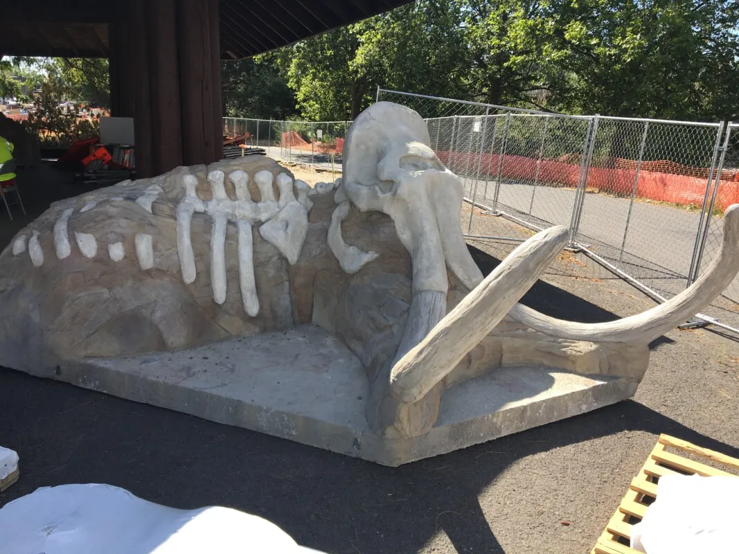
There will be an Invitation-Only Grand Opening of the Ice-Age Floods Playground in Spokane’s Riverfront Park on Friday, May 21st from 11:00 to noon. Then playground will the be open to the public beginning at noon on Friday. All ages are welcome! Click here for more information. The “soft ”pavement has been poured, including some mammoth tracks leading to various features. The Flood Fall is spectacular & will be sure to elicit many screams of delight. The present educational texts & images are temporary. The permanent ones will be installed at a later date.
Nick Zentner – More Geology Videos

Are you looking for new geology videos? Nick Zentner has done a long series live geology lectures from his home in Ellensburg and posted them online to his YouTube channel https://www.youtube.com/user/GeologyNick/videos He is now recording a series of “Nick on the Fly” virtual field trips and posting them on the same YouTube channel https://www.youtube.com/user/GeologyNick/videos Join Nick as he explores the geology of the Pacific NW and many other topics.
Use Social Distancing Time to Explore the Floods with Our Interactive Online Map
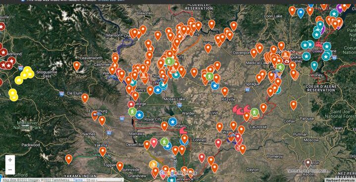
If you’ve ever tried to explore the Ice-Age Floods with a guidebook you’ll know how difficult and frustrating it can be to find and learn about the features in the area you’re visiting. Well, there’s now a solution to that problem; an interactive map that’s available wherever you have internet access. The map features over 300 points of interest throughout our 4-state area, with a description and images that slide out when you click on one of the markers. More features are being added all the time, and we’re planning to expand the map with features related to the Lake Bonneville Flood event that rampaged through the area during the time of the Ice-Age Floods. Since this is an internet-based map, it’s also easy to get driving directions to the site from wherever you are starting from. You can also easily build an informative field trip, exploring and learning about a number of other nearby features with just a few clicks of your mouse. We feel this may be the most useful field guide ever developed to explore ice-age Floods and glacial features throughout our 4-state region. AND it’s absolutely FREE! The only shortcomings we see are 1) the map requires internet access, which isn’t always available in far-flung areas of our region, and 2) we may not have every point-of-interest on the map (YET!). If we’re missing something you think is important we encourage you to submit your suggestion. We also appreciate any comments and/or corrections by email to Webmaster@IAFI.org. We sincerely hope you enjoy using this guide to poke around these fascinating ice-age features.
Explore the Ice Age Floods with 12 New IAFI Brochures

IAFI has compiled 12 brand-new, full-color brochures into a packaged set to help guide you in visiting spectacular ice-age features across all of our 11 Ice Age Floods chapter areas. With these brochures as your guides you can explore the paths of the Ice Age Floods from Montana through Idaho, central Washington and northern Oregon, and even delve into the many glacial features of northwest Washington. Click on any of the brochure covers below to see a full size printable PDF version (note: you’ll need to scale down to print on 8.5×11 letter size paper). Packets of all 12 full-size brochures are NOW available through the IAFI Store and at participating local outlets. Click a cover to open a PDF of any of the brochures below
Ice Age Floods Playscape in Spokane Riverfront Park
By late summer or early fall of 2020, Riverfront Park will have an interactive playground that will be almost an acre in size. The great ice age floods that shaped the Inland Northwest also are shaping the new playground on the North Bank of Riverfront Park. The playground’s theme is Ice Age Floods, which will allow kids to both play and learn about Spokane’s history at the same time. Designers thought to add this theme since the Ice Age Floods had a significant impact on Spokane’s geology. “That parcel has always felt like an outlier,” says Dell Hatch, a landscape architect and principal in charge of the North Bank project for Bernardo|Wills Architects (BWA), “so it’s really cool to integrate that north side as another element of the park. Kids are going to be able to discover as they play, in the sand areas and as water moves through the playground, They’re going to be learning without even knowing they’re learning.” Soon the space will be home to a wheels park for skateboards, inline skates and scooters, new Hoopfest courts, parking served by improved access off Washington Street, and a new operations building to serve the park’s back-of-house needs. The North Bank will also connect with the soon-to-be-built Sportsplex, located on the basalt bluff above. But the centerpiece will be a 1-acre-plus destination playground themed around the Ice Age Floods that carved out the Spokane River Gorge some 15,000 years ago. “You are going to see some water play features, you’ll see some geology features too, some rocks in different elements the kids can climb around as they learn what the geology of eastern Washington is and why it is so special to our region,” said Fianna Dickson with Spokane Parks and Recreation. Some playground features will help children learn about nature and geology, like a stream that teaches about currents and damming. A climbing wall, rope suspension bridge, large rocks that children can climb, a splash pad, and a 30-foot tall climbing tower with tube slides, would be play elements in the park. “We’re working with Nigel Davies [a geologist from EWU], and we’ve held a workshop with the Ice Age Floods Institute,” says Bill LaRue, a landscape architect with BWA and project manager for the North Bank. “We’re working in like five or six different types of basalt, fossils of local flora and fauna — even a petrified forest.”
Bretz and His Floods Story – National Geographic
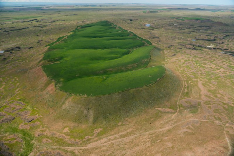
National Geographic has published an outstanding article, “Formed by Megafloods, This Place Fooled Scientists for Decades”, about J Harlan Bretz and his outrageous, fantastical theories of a landscape shaped by huge floods. Most Ice Age Floods aficionados are generally aware of the story, but this one is so detailed and well written it’s worth reading for the story-telling value alone. Please see: This National Geographic site: