Asteroid That Decimated the Dinosaurs May Have Struck in Spring
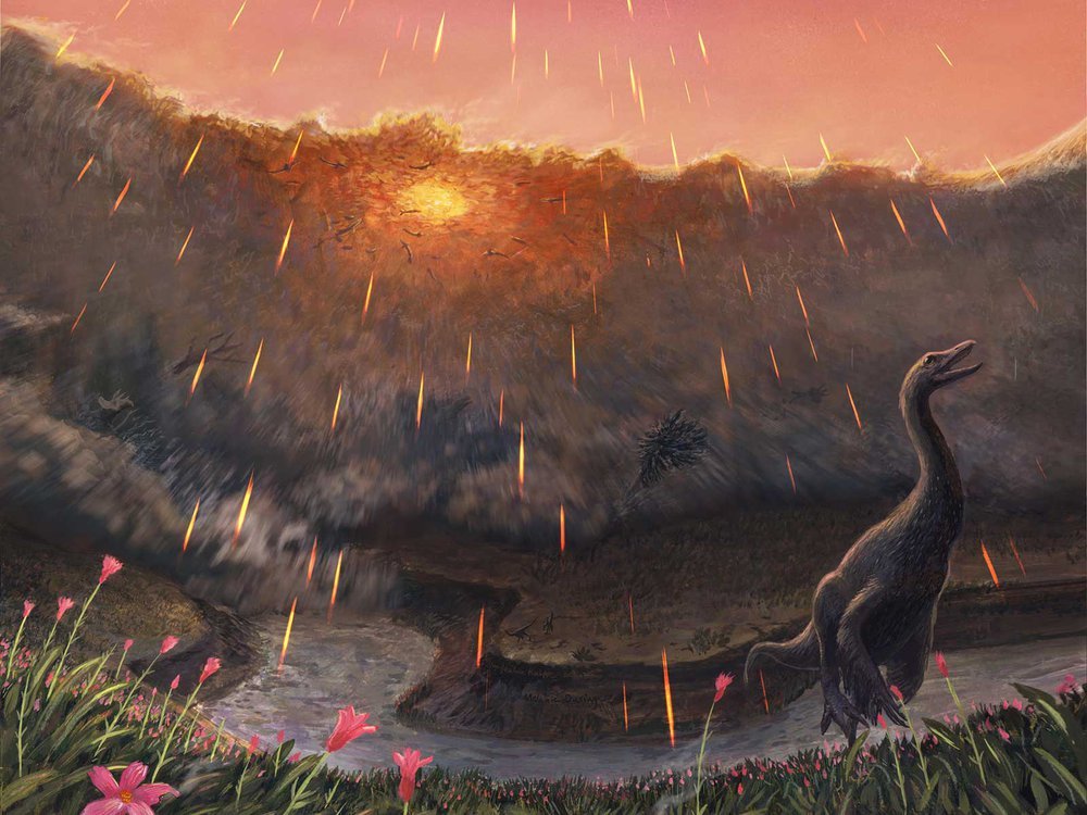
Spring may have been when a roughly seven-mile-wide asteroid struck the Earth, immediately triggering the mass extinction that would wipe out 76 percent of known species. That key piece of timing doesn’t come from dinosaurs, but from the fish that swam in the waters dinosaurs drank from. By studying the fossil bones of these fish and comparing them to their modern counterparts, Vrije Universiteit Amsterdam paleontologist Melanie During and colleagues have come to the conclusion that the impact that ended the Age of Dinosaurs most likely occurred in the spring. Like their modern counterparts, ancient sturgeons and paddlefish of the Hell Creek Formation, found in the “Tanis” fossil site in North Dakota, grew in cycles. Those researchers proposed that this place contains critical clues about the first minutes and hours of what transpired after impact—including well-preserved fossil fish that contain asteroid impact debris in their gills. During warmer months when food was plentiful, the ancient fish grew and added more bone tissue just as their modern relatives do. During cooler, harsher months, however, their growth slowed and left a line—called a line of arrested growth, or LAG—in their bones. In addition, the bones of these fish contained signatures from oxygen and carbon isotopes. The geochemical signals in these isotopes were influenced by what the fish were eating and the waters they swam in, a natural phenomenon that has been used by paleontologists to study everything from when early whales took to the seas to what plants ancient herbivores ate. Details of the prehistoric sturgeon and paddlefish bones indicate that these fish had not yet hit the peak of their annual growth spurt, which would be expected during the warmest parts of the year. The carbon isotope ratios in the paddlefish bones also match up with this pattern. If these ancient fish lived according to a similar annual cycle as their living relatives, then the signatures in their bones hint that they perished in spring. The fact that tiny spherules thrown into the air during the impact were found in their gills places the time of death within minutes or hours of the end-Cretaceous impact. Together, these lines of evidence suggest that the impact took place while the Northern Hemisphere was in spring and the Southern Hemisphere was still in winter. Read more in the Smithsonian Magazine article by Riley Black that this was taken from, or a Science Alert article that also recaps the paper published in Nature.
Waning Pleistocene Ice Sheet Affected Megaflood Paths and Local Shorelines
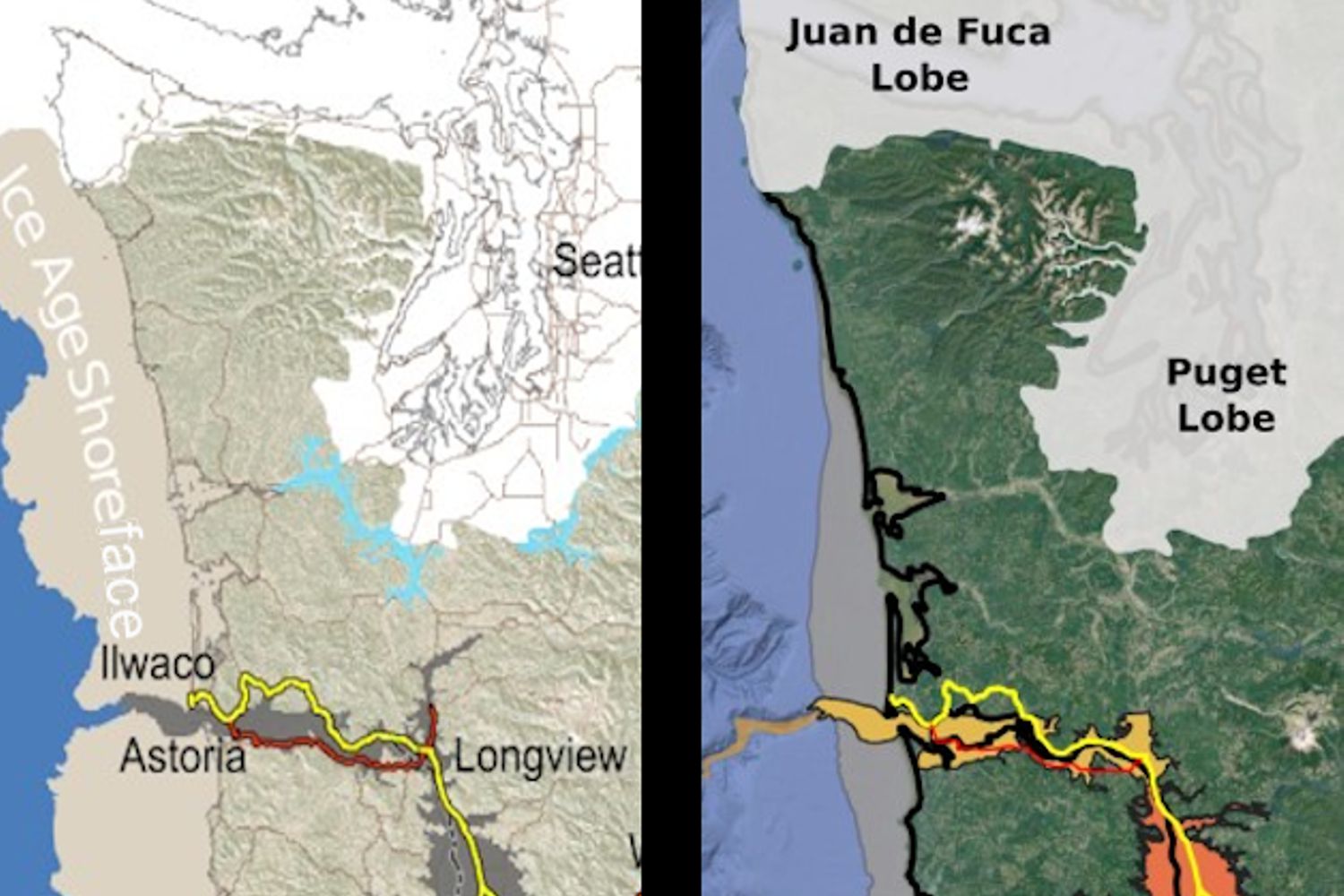
Have you ever thought about the how the weight of the ice-age Cordilleran ice sheet might affect the underlying Earth’s crust. There is strong evidence that the crust was depressed hundreds of feet beneath the ice, and since the crust is relatively thin and rigid over a plastic aesthenosphere, that also caused the crust for some distance beyond the ice margins to tilt toward the ice sheet. A new modeling study explored how changes in topography due to the solid Earth’s response to ice sheet loading and unloading might have influenced successive megaflood routes over the Channeled Scablands between 18 and 15.5 thousand years ago. The modeling found that deformation of Earth’s crust may played an important role in directing the erosion of the Channeled Scabland. Results showed that near 18 thousand year old floods could have traversed and eroded parts of two major Channeled Scabland tracts—Telford-Crab Creek and Cheney-Palouse. However, as the ice-age waned and the ice sheet diminished 15.5 thousand years ago, crustal isostatic rebound may have limited megaflood flow into the Cheney–Palouse tract. This tilt dependent difference in flow between tracts was governed by tilting of the landscape, which also affected the filling and overspill of glacial Lake Columbia directly upstream of the tracts. These results highlight one impact of crustal isostatic adjustment on megaflood routes and landscape evolution. Other studies have shown that relative ice-age sea levels were over 300 feet lower worldwide due to the volume of water locked up in ice sheets. Typical depictions of the shoreface extent are generally based on a 300 ft. depth contour, but there is strong evidence that shorelines were up to 200+ ft. higher than present day in marine areas adjacent to ice sheets, again because the crust was depressed by the weight of the ice sheer. A more accurate representation might show a much narrower shoreface in ice-free areas nearer to the ice sheet margin. However, in the Haida Gwaii Strait at the margin of the ice sheet the lower thickness of the ice sheet meant that local shorelines were as much as 550 feet lower than they are today. This was because the much greater thickness of the center of the ice sheet served to push upwards areas at the edge of the continental shelf in a crustal forebulge. It is now widely thought that these emergent ice-free land areas might have provided a viable coastal migration corridor for early peoples making their way to the Americas from Asia during the Pleistocene.
Mammoth and Horse DNA Rewrite Ice Age Extinctions
New research reveals the ancient animals survived some 8,000 years later than previously thought Frozen soil samples collected around a decade ago are rewriting our understanding of iconic Ice Age animals like the woolly mammoth. The soil samples were pulled from Canada’s permafrost in the early 2010s, but no work on them had been published until recently. A new analysis of the DNA samples reveals that woolly mammoths, wild horses and steppe bison were around as recently as 5,000 years ago—some 8,000 years later than previously thought, according to a study published this week in Nature Communications. Scientists reconstructed the ancient ecosystem using radiocarbon dating of plant material trapped in the soil in combination with microscopic genomic sequences from animal species. Their results showed something unexpected: Large mammals like mammoths and horses were already on the decline before the climate warmed. The scientists found evidence of woolly mammoth and North American horse DNA as recently as 5,000 years ago, which means the animals held out until the mid-Holocene. Excerpted from the Smithsonian Magazine article by Corryn Wetzel
23,000 Year Old Human Footprints Found in New Mexico

Articles in Science Alert and the New York Times report on a well documented age for many sets of human footprints as old as 23,000 years in the ancient lake shore sands of White Sands, New Mexico. “The footprints were first discovered in 2009 by David Bustos, the park’s resource program manager. Over the years, he has brought in an international team of scientists to help make sense of the finds. Together, they have found thousands of human footprints across 80,000 acres of the park. One path was made by someone walking in a straight line for a mile and a half. Another shows a mother setting her baby down on the ground. Other tracks were made by children.” Beginning in 2019, two United States Geological Survey (USGS) research scientists, Dr. Jeffrey Pigati and Kathleen Springer, began working on the site and found ancient seeds of ditch grass associated with various sets of footprints. The oldest footprints so far have been found in seed beds radiocarbon age-dated as old as 22,800 years, and the youngest footprints dated to about 21,130 years ago. Some scientists still have concerns the seeds might have absorbed older carbon from the lake waters. But in general this research is strongly indicative that humans were present in the Americas long before the generally accepted 15,600-year-old footprint found in Chile or the 13,000 year age of human tools found near Clovis, NM. If humans were well established in New Mexico 23,000 years ago, they must have started spreading down from Alaska long before that. “That starts to wind back the clock,” said Dr. Reynolds of Bournemouth University. Some researchers feel the migration might have been along the coast during the last major ice advance of the Pleistocene, while others argue people could have traveled inland more than 32,000 years ago, before Ice Age glaciers reached their maximum extent and blocked off that route. Regardless of the possible migration route, this new evidence opens up new possibilities that humans may have been present in our local area even before the earliest of the Ice Age Floods, about 18,000 years ago. While the floods could have wiped away most traces of early people in the area, the window of human habitation may be much greater than scientifically documented to date.
Chicxulub Asteroid Tsunami ‘Megaripples’
In what may be the most dramatic mass extinction in Earth’s history, an asteroid impacted our planet 66 million years ago near what is now Chicxulub on the Yucatan Peninsula. The resulting hellscape extinguished 75 percent of then living species – including all non-avian dinosaurs. Over the last few years, scientists have discovered many more traces of this cataclysmic impact, providing us with ever greater details of its extreme aftermath – from world-encircling dust to wildfires up to 1,500 kilometers (930 miles) from the impact site. In 2019, a team found fossil records of the immediate hours after, including evidence of debris swept up by the resulting tsunami. Now, researchers have discovered enormous megaripples engraved by the tsunami in sediments 1,500 meters (5,000 feet) below what is now central Louisiana. By analyzing seismic imaging data for central Louisiana, gained from a fossil fuel company., the team determined the imprinted ripple crests form a straight line right back to the Chicxulub crater and their orientation is consistent with the impact. These megaripple features have average wavelengths of 600 meters and average wave heights of 16 meters making them the largest ripples documented on Earth. Compare that to the largest Camas Prairie megaripple at 289m x 17m. Modelling of this monstrous tsunami suggests its waves would have reached a staggering 1,500 meters high (nearly 1 mile) after the Richter scale 11 megaearthquake triggered by the collision. The aftereffects would have been particularly devastating in the regions surrounding the impact site, sweeping sea life onto land and land life into the sea. “Tsunami continued for hours to days as they reflected multiple times within the Gulf of Mexico while diminishing in amplitude,” the team wrote. What carved out the ripples we can still detect today were the forces from the massive walls of water smashing into the shallow shelf near the shores, and reflecting back towards their source. Excerpted from: sciencealert.com/tsunami-megaripples-from-the-dinosaur-killing-asteroid-impact-discovered-in-louisiana Read another article at: https://www.sciencetimes.com/articles/32252/20210713/dino-killer-space-rock-left-fossilized-megaripples-mile-high-giant.htm
WA Geology Releases Stunning Lidar Images

The Washington Geological Survey (WGS) has released 50 high-resolution lidar-derived images of the State’s geology and geomorphology through the Washington State DNR’s Flickr page. The images are available in 16:9 format (7,200 x 4,050 pixels) and 4:3 format (7,200 x 5,400 pixels). Ten of the images are new (see below) and 40 of them were previously available as screen wallpaper (at a lower resolution). Additionally, WGS has released several full-resolution lidar image series that reveal the State’s geology. These images are great for earth science presentations, learning about lidar, and for using as digital wallpaper. They are also large enough to support large-format printing. Here are direct links to the image galleries:
The Washington 100 Geotourism Guide

Check out this video about the Washington 100, a cool new geotourism website by the Washington Geological Survey featuring 100 places to experience amazing geology in Washington State. Then explore the website itself at wa100.dnr.wa.gov
New Saber-Toothed Cat Species May Have Hunted Rhinos in America
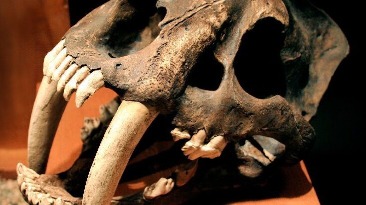
Using detailed fossil comparison techniques, scientists have been able to identify a giant new saber-toothed cat species, Machairodus lahayishupup, which would have prowled around the open spaces of North America between 5 and 9 million years ago. One of the biggest cats ever discovered, M. lahayishupup is estimated in this new study to have a body mass of some 274 kilograms (604 pounds) or so, and possibly even bigger. It’s an ancient relative of the well-known Smilodon, the so-called saber-toothed tiger. A total of seven M. lahayishupup fossil specimens, including upper arms and teeth, were analyzed and compared with other species to identify the new felid, with the fossils collected from museum collections in Oregon, Idaho, Texas, and California. Upper arms are crucial in these cats for killing prey, and the largest upper arm or humerus fossil discovered in the study was about 1.4 times the size of the same bone in a modern-day lion. That gives you an idea of just how hefty and powerful M. lahayishupup would have been. “We believe these were animals that were routinely taking down bison-sized animals,” says paleontologist Jonathan Calede from Ohio State University. “This was by far the largest cat alive at that time.” Rhinoceroses would have been abundant at the same and may have been animals that M. lahayishupup preyed on, alongside camels and sloths significantly bigger than the ones we’re used to today. Peering back so many millions of years into the past isn’t easy, and the researchers say that a more detailed saber-tooth cat family tree is going to be needed to work out exactly where this species fits in. The findings also open up some interesting evolutionary questions about these giant cats. “It’s been known that there were giant cats in Europe, Asia, and Africa, and now we have our own giant saber-toothed cat in North America during this period as well,” says Calede. “There’s a very interesting pattern of either repeated independent evolution on every continent of this giant body size in what remains a pretty hyper-specialized way of hunting, or we have this ancestral giant saber-toothed cat that dispersed to all of those continents. It’s an interesting paleontological question.” Excerpted from SCIENCE ALERT article by DAVID NIELD8 MAY 2021
Kennewick Man – Today in History

Kennewick Man is the name generally given to the skeletal remains of a prehistoric Paleoamerican man found on a bank of the Columbia River near Kennewick, Washington, on July 28, 1996. Two young men discovered the skull of Kennewick Man when they stepped on something that looks like a large rock. They had stumbled upon a human skull while wading in the shallows along the Columbia River. They gave the skull to police, They called the police. The police brought in the Benton County coroner, Floyd Johnson, who was puzzled by the skull, and he in turn contacted James Chatters, a local archaeologist. Chatters and the coroner returned to the site and, in the dying light of evening a skeleton was found scattered nearby, complete with a stone spear point driven into the hip. They plucked almost an entire skeleton from the mud and sand. It is one of the most complete ancient skeletons ever found and anthropologists determined it was at least 9,200 years old. It was the oldest nearly complete skeleton found in North America, but the discovery was more than a thrilling moment for archaeologists. The find kicked off a long-running scientific and cultural controversy.— and it sparked a legal battle that lasted more than two decades. Get more of the story at https://www.smithsonianmag.com/history/kennewick-man-finally-freed-share-his-secrets-180952462/
Glacial Lake Missoula – Inspired Classroom Videos

The Glacial Lake Missoula chapter has worked with Inspired Classroom LLC to produce a series of 9 short (3-7 minute) videos exploring different aspects of the Ice Age Floods in the Glacial Lake Missoula area. The entire set is posted to the Inspired Classroom LLC YouTube channel, including a full 31 minute version (below) that compiles the entire set.