Unearthing the Secrets of Spokane Valley: A Recap of the IAFI June Jamboree
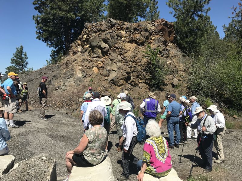
This year’s IAFI June Jamboree delved into the fascinating geological history of Spokane Valley, contrasting it with the iconic Grand Coulee and Dry Falls, explored during last year’s Jubilee. Challenging the Landscape: Unlike the open spaces of Dry Falls, Spokane Valley presented a unique challenge – showcasing evidence of Ice Age Floods within an urban environment. Our chapter tackled this brilliantly, organizing hikes and car caravans departing from convenient public parks and commercial areas. Evening Explorations: The program’s highlights included captivating lectures. Professor Emeritus Dean Kiefer shed light on J Harlen Bretz’s Spokane associates, while renowned naturalist Jack Nesbit brought the story of the first Columbian Mammoth discovered near Latah Creek in the 1800s to life. Celebrating Success: The Jamboree culminated in a relaxed gathering at Mirabeau Meadows. Registrants, leaders, and participants exchanged insights and experiences, with a resounding appreciation for the chapter’s efforts. Comparisons were drawn, highlighting how our Spokane Valley exploration continued the excellence of the Puget Lobe’s outing at Dry Falls last year. A Delicious Finale: The grand finale was a catered Longhorn Barbecue overflowing with delicious food. Everyone left satisfied, with many even taking home doggie bags to savor the flavors afterward. Check out more images from the event in this Google Photo Album. Meet the Masterminds: Linda & Mike McCollum: This dynamic professor emerita and a research geologist duo co-led tours and car caravans, sharing their latest research on the Spokane area’s Ice Age Floods, and shaping the Jamboree’s theme. Michael Hamilton: A gifted geologist, Michael led hikes and the bus trip, encouraging questions and offering honest answers. Don Chadbourne & Chris Sheeran: Don, the chapter treasurer, managed logistics with expertise, while Chris, our media and registration guru, ensured a smooth experience. Melanie Bell Gibbs: A past president and national board member, Melanie oversaw participant check-in and badge distribution. Dick Jensen: Dick handled bus transportation and provided crucial support throughout the Jamboree. Jim Fox: The chapter vice president secured speakers and offered his assistance wherever needed. We also owe a great deal to the participant volunteers who proved invaluable in assisting us in all our efforts. Through the combined efforts of many the IAFI June Jamboree was a resounding success, fostering exploration, education, and a deeper appreciation for the Spokane Valley’s unique geological heritage. Being present with so much information and conversation among such extensive expertise was to witness the scientific process in action. Meeting people from other chapters was particularly nice, putting faces with names we know. We all learned a lot.
Let Your Feet, and Your Imagination Roam at Rowena Crest and Tom McCall Preserve

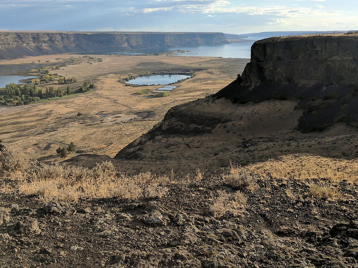
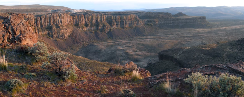
Scenic Rowena Crest and the Tom McCall Preserve area provide an incredibly scenic place to let your feet, and your imagination wander as you look out on a major chokepoint along the Ice Age Floods path. The wildflower displays are amazing during the Spring, but several compelling flood-related features are visible from the vantage of the Rowena Crest Viewpoint any time of year. Rowena Crest lies nearly 700 feet above the Columbia River at the upstream end of the Rowena Plateau, a miles-long plateau that the river flows along. Just upriver from the plateau is the narrow section of the Gorge known as the Rowena Gap The drive to the viewpoint on old Hwy 30 from either east or west is a spectacular ride through a wonderous section of the Columbia River Gorge. A roundabout parking area at the viewpoint, with a safety wall above a sheer cliff, provides a great observation point eastward toward Rowena Gap. At Rowena Crest it’s easy to imagine what it might have been like to witness the approach of those massive floods. There is not yet scientific evidence that humans were in the area to bear witness to the Ice Age Floods, but there is solid evidence of humans in the Americas by that time. And there is growing concensus that if they came in during a glacial maximum, they would have come in by a coastal route that offered plentiful food and shelter for their journey. The mouth of the Columbia River would have been the first major waterway path inland that might have led them to settle in the area of the Floods. Your village might have been situated across the Columbia at the mouth of the Klickitat River where the town of Lyle now sits. If you were foraging, or just relaxing, atop Rowena Crest on a late summer day, you might have felt the ground begin to temble as if there were a small earthquake, but the trembling would have slowly increased for a few hours. Eventually you would have heard a low roaring sound that also grew over an hour or more before you could see turbulent brown muddy water begin flooding across the broad basin to the east. Then the roaring flood of water, only a few feet deep at first, would have entered the narrows, now called Rowena Gap, and sped on, crashing against the promontory you’re standing on and being diverted toward your village which was quickly washed away by the muddy torrent. But the muddy flood waters would have kept rising, unlike the Spring floods you’re used to on the Columbia, becoming a hundred feet deep, then two hundred as the levels just kept rising. Soon a huge whirlpool formed in the flood waters near the base of the promontory and a giant eddy formed where your village had been as flood waters flowed backward up the Klickitat River even as the bulk of the water continued downstream on the main stem of the Columbia. As the flood waters reached 400 and 500 feet deep and kept coming, suddenly to your right and left, huge blocks of the promontory broke off and slumped down into the rampaging flood waters. Now, even more fearful, you would have begun running south toward higher ground, climbing higher and higher as the still rising flood waters poured across the plateau and plunged into the small creek valley to the west, tearing away at the valley walls and massively widening that little valley. Eventually the flood waters stopped chasing you upward as you climbed higher, 200 then 300 feet above the now submerged promontory. Now, as you turned and looked out across that expanse of muddy water you could see massive white blocks of ice being carried along on the flood waters, similar but inconceivably larger than the ice blocks carried on the river during the Spring floods. But the flood waters didn’t begin to recede that day, nor the next, as they might in the Spring floods. In fact it was almost half a lunar cycle before they began to slowly recede, exposing a mud coated Columbia River valley that was now noticeably wider, with layers of shear vertical rock walls extending over 1000 feet above the normal river level below. As you began the recovery from the floods devastation, your family returned from from their hunting and gathering in the high mountain meadows, and you have an incredible story to pass along to them and your ancestors. This story is easy to imagine as you look out to the east from Rowena Crest. The onrushing Ice Age Floods waters easily flowed over the low relief of the broad Dalles Basin to the east, but the major Rowena Gap created a chokepoint in the path of the floods as they made their way through the Columbia River Gorge. This “hydraulic dam” forced the flood waters to build to over 1000 feet deep in this area, flowing hundreds of feet deep over Rowena Crest while forming a temporary lake in The Dalles basin. It is estimated that many of the 40-100 Ice Age Floods may have taken up to a month to completely flush through the system to the Pacific Ocean, but the duration of the flood waters at any point along the path probably lasted less than a couple of weeks. But this was more than enough to create several major floods features visible from this vantage point. At Columbia River level below and east of the promontory is a round Kolk pond that was created by giant whirlpools in the flood waters as they were deflected around the Rowena Crest promontory. Other similar Kolk features can also be seen on the Dallesport area to the east, and along the hiking path atop Rowena Crest where they are marked by surrounding groves of oak trees. Across the Columbia, the floods deposited a huge eddy gravel bar that the entire town of Lyle, Washington is built upon. The Klickitat River was backed
How did humans first reach the Americas?

During the last ice age, which route was taken by the first humans to reach the Americas, and did they travel by foot, boat or both? Humans first arrived in North America at least 15,500 years ago. Exactly how they got there, however, constitutes one of the longest-standing debates in archaeology. For decades, scientists assumed that people first arrived in the Americas by walking south from the now-flooded land bridge in the Bering Strait that once connected Russia to Alaska when sea levels were lower during the last ice age. But recent evidence suggests that these people were not the first to set foot on the continent. According to the now-dominant “coastal route theory,” that distinction belongs to humans who boated down the Pacific coast several millennia earlier. A 2023 study(opens in new tab), for instance, found that coastal conditions were favorable during two time windows: from 24,500 to 22,000 years ago, and from 16,400 to 14,800 years ago. And while the science is far from settled, the evidence increasingly points to the first Americans arriving by sea or land along the coast. “The pendulum is swinging in support of the coastal corridor being the route taken by the first Americans,” Michael Waters(opens in new tab), director of the Center for the Study of the First Americans at Texas A&M University, told Live Science in an email. “But we still need the smoking gun: an early site along the coast.” Until 20 years ago, the best available archaeological evidence(opens in new tab) suggested that humans first arrived in North America about 13,000 years ago. The rise of the Clovis people — whose 13,400-year-old remains were discovered in Clovis, New Mexico, in the early 1900s — coincided perfectly with the formation of an ice-free corridor along the Rocky Mountains. Scientists assumed that these humans crossed the Bering Land Bridge into what is now Alaska, and then turned south to march onward to New Mexico through that convenient corridor. This remains the prevailing theory as to how the Clovis people made it to the Americas. “It seems very likely that people did arrive from northeast Asia via the ice free corridor once this route was open and viable,” Todd Braje, chair of anthropology at San Diego State University, told Live Science in an email. But recent excavations suggest that the Clovis were not the first Americans. A 2011 paper in the journal Science presented evidence of tools crafted by humans in Texas from up to 15,500 years ago, and a 2021 paper in Science described 23,000-year-old footprints in New Mexico. (However, the footprint date is disputed by a 2022 study in the journal Quaternary Research, which posits that the plant seeds the original team used to radiocarbon-date the footprint layer are problematic.) These “pre-Clovis people” would have had to migrate to America long before the ice-free corridor opened up. “The earliest the inland corridor was open is 14,300 years ago,” Waters said. “It is impossible to have people in Texas and Idaho at 16,000 years ago, and Florida at 14,600 years ago, come through the corridor. They must have come a different way.” How the pre-Clovis people got to America without an inland corridor to take them south from the Bering Strait remains an open question. “With the breaking of the Clovis barrier in the 1990s, we know people were in the Americas prior to at least 14,000 years ago, but when people first arrived and by what route or routes remains unknown,” Braje said. “There are now lively debates on the topic but the bottom line is that no one knows definitely.” The prevailing theory is that the pre-Clovis people arrived by watercraft. “The route taken by the initial migrants was almost certainly along the coast,” said Matthew Des Lauriers(opens in new tab), director of the Applied Archaeology Program at California State University, San Bernardino. Des Lauriers described the pre-Clovis as sophisticated maritime hunter-gatherers, who would have cast off south from the Bering Land Bridge and subsisted on fish and game as they voyaged down the Pacific coast. Ultimately, Des Lauriers said, these intrepid seafarers parted ways. Some pre-Clovis people followed rivers inland, while others continued south as far as Chile. “The ocean would always have provided resources for skilled fishermen and hunters,” Des Lauriers told Live Science in an email. “The most likely scenario is one of coastal fisher-hunter-gatherers moving along the North Pacific Coast.” Recent work from geologists has lent support to the theory that the Clovis people arrived via an inland corridor, while the pre-Clovis people took a coastal route. Beryllium-10 dating of glacial boulders(opens in new tab) along the ice-free corridor suggests that the corridor opened about 13,800 years ago. And studies suggest that a strip of unglaciated land should have existed along the Pacific coast of Alaska and British Columbia 16,000 years ago — prime real estate for a coastal corridor. As the field of ancient genetics has blossomed, multiple studies(opens in new tab) have provided additional evidence that the first Americans arrived between 15,000 and 17,000 years ago. “It is gratifying to see the archaeological and genetic evidence converging to tell the same story,” Waters said. “Finally, we have a much better understanding of the chronology of the opening of the two corridors, and the evidence now supports a coastal migration route.” Nonetheless, physical evidence for both corridors is still lacking. Significant archaeological, genetic and geologic legwork will be necessary before we can firmly point to the lives and times of the first Americans and begin to describe, with confidence, how they arrived in America. “There are very few sites along the Pacific Coast that are pre-Clovis in age, and much work needs to be accomplished to find potential early coastal sites,” Braje said. “We have no definitive answers about when and how people first arrived in the Americas.” Reproduced from an article by Joshua A. Krisch, published in Live Science More on archaeological research into early human migration into the Americas: The Fertile Shore
Bering Land Bridge Formed Surprisingly Late During Last Ice Age
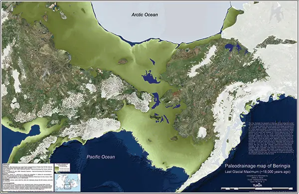
By reconstructing the sea level history of the Bering Strait, scientists found that the strait remained flooded and the Bering Land Bridge connecting Asia to North America did not emerge until around 35,700 years ago, less than 10,000 years before the height of the last ice age (known as the Last Glacial Maximum), and not long before humans are thought to have begun migrating into the Americas. The new findings indicate that the growth of the ice sheets—and the resulting drop in sea level—occurred surprisingly quickly and much later in the glacial cycle than previous studies had suggested. “It means that more than 50 percent of the global ice volume at the Last Glacial Maximum grew after 46,000 years ago,” said Tamara Pico, assistant professor of Earth and planetary sciences at UC Santa Cruz and a corresponding author of the paper. “This is important for understanding the feedbacks between climate and ice sheets, because it implies that there was a substantial delay in the development of ice sheets after global temperatures dropped.” Global sea levels drop during ice ages as more and more of Earth’s water gets locked up in massive ice sheets, but the timing of these processes has been hard to pin down. During the Last Glacial Maximum, which lasted from about 26,500 to 19,000 years ago, ice sheets covered large areas of North America. Dramatically lower sea levels uncovered a vast land area known as Beringia that extended from Siberia to Alaska and supported herds of horses, mammoths, and other Pleistocene fauna. As the ice sheets melted, the Bering Strait became flooded again around 13,000 to 11,000 years ago. The new findings are interesting in relation to human migration because they shorten the time between the opening of the land bridge and the arrival of humans in the Americas. The timing of human migration into North America remains unresolved, but some studies suggest people may have lived in Beringia throughout the height of the ice age. “People may have started going across as soon as the land bridge formed,” Pico said. The new study used an analysis of nitrogen isotopes in seafloor sediments to determine when the Bering Strait was flooded during the past 46,000 years, allowing Pacific Ocean water to flow into the Arctic Ocean. First author Jesse Farmer at Princeton University led the isotope analysis, measuring nitrogen isotope ratios in the remains of marine plankton preserved in sediment cores collected from the seafloor at three locations in the western Arctic Ocean. Because of differences in the nitrogen composition of Pacific and Arctic waters, Farmer was able to identify a nitrogen isotope signature indicating when Pacific water flowed into the Arctic. Pico, whose expertise is in sea level modeling, then compared Farmer’s results with sea level models based on different scenarios for the growth of the ice sheets. “The exciting thing to me is that this provides a completely independent constraint on global sea level during this time period,” Pico said. “Some of the ice sheet histories that have been proposed differ by quite a lot, and we were able to look at what the predicted sea level would be at the Bering Strait and see which ones are consistent with the nitrogen data.” The results support recent studies indicating that global sea levels were much higher prior to the Last Glacial Maximum than previous estimates had suggested, she said. Average global sea level during the Last Glacial Maximum was about 130 meters (425 feet) lower than today. The actual sea level at a particular site such as the Bering Strait, however, depends on factors such as the deformation of the Earth’s crust by the weight of the ice sheets. “It’s like punching down on bread dough—the crust sinks under the ice and rises up around the edges,” Pico said. “Also, the ice sheets are so massive they have gravitational effects on the water. I model those processes to see how sea level would vary around the world and, in this case, to look at the Bering Strait.” The findings imply a complicated relationship between climate and global ice volume and suggest new avenues for investigating the mechanisms underlying glacial cycles. In addition to Pico and Farmer, the coauthors include Ona Underwood and Daniel Sigman at Princeton University; Rebecca Cleveland-Stout at the University of Washington; Julie Granger at the University of Connecticut; Thomas Cronin at the U.S. Geological Survey; and François Fripiat, Alfredo Martinez-Garcia, and Gerald Haug at the Max Planck Institute for Chemistry in Germany. This work was supported by the National Science Foundation. Published in Proceedings of the National Academy of Sciences. Reprinted from UC Santa Cruz Newsletter, By Tim Stephens
OSU Archaeologists Find Oldest Known Projectile Points in the Americas

Oregon State University archaeologists have uncovered projectile points in Idaho that are thousands of years older than any previously found in the Americas, helping to fill in the history of how early humans crafted and used stone weapons. The 13 full and fragmentary projectile points, razor sharp and ranging from about half an inch to 2 inches long, are from roughly 15,700 years ago, according to carbon-14 dating. That’s about 3,000 years older than the Clovis fluted points found throughout North America, and 2,300 years older than the points previously found at the same Cooper’s Ferry site along the Salmon River in present-day Idaho. “From a scientific point of view, these discoveries add very important details about what the archaeologic al record of the earliest peoples of the Americas looks like,” said Loren Davis, an anthropology professor at OSU and head of the group that found the points. “It’s one thing to say, ‘We think that people were here in the Americas 16,000 years ago;’ it’s another thing to measure it by finding well-made artifacts they left behind.” Previously, Davis and other researchers working the Cooper’s Ferry site had found simple flakes and pieces of bone that indicated human presence about 16,000 years ago. But the discovery of projectile points reveals new insights into the way the first Americans expressed complex thoughts through technology at that time, Davis said. The Salmon River site where the points were found is on traditional Nez Perce land, known to the tribe as the ancient village of Nipéhe. The land is currently held in public ownership by the federal Bureau of Land Management. The points are revelatory not just in their age, but in their similarity to projectile points found in Hokkaido, Japan, dating to 16,000-20,000 years ago, Davis said. Their presence in Idaho adds more detail to the hypothesis that there are early genetic and cultural connections between the ice age peoples of Northeast Asia and North America. “The earliest peoples of North America possessed cultural knowledge that they used to survive and thrive over time. Some of this knowledge can be seen in the way people made stone tools, such as the projectile points found at the Cooper’s Ferry site,” Davis said. “By comparing these points with other sites of the same age and older, we can infer the spatial extents of social networks where this technological knowledge was shared between peoples.” These slender projectile points are characterized by two distinct ends, one sharpened and one stemmed, as well as a symmetrical beveled shape if looked at head-on. They were likely attached to darts, rather than arrows or spears, and despite the small size, they were deadly weapons, Davis said. “There’s an assumption that early projectile points had to be big to kill large game; however, smaller projectile points mounted on darts will penetrate deeply and cause tremendous internal damage,” he said. “You can hunt any animal we know about with weapons like these.” These discoveries add to the emerging picture of early human life in the Pacific Northwest, Davis said. “Finding a site where people made pits and stored complete and broken projectile points nearly 16,000 years ago gives us valuable details about the lives of our region’s earliest inhabitants.” The newly discovered pits are part of the larger Cooper’s Ferry record, where Davis and colleagues have previously reported a 14,200-year-old fire pit and a food-processing area containing the remains of an extinct horse. All told, they found and mapped more than 65,000 items, recording their locations to the millimeter for precise documentation. The projectile points were uncovered over multiple summers between 2012 and 2017, with work supported by a funding partnership held between OSU and the BLM. All excavation work has been completed and the site is now covered. The BLM installed interpretive panels and a kiosk at the site to describe the work. Davis has been studying the Cooper’s Ferry site since the 1990s when he was an archaeologist with the BLM. Now, he partners with the BLM to bring undergraduate and graduate students from OSU to work the site in the summer. The team also works closely with the Nez Perce tribe to provide field opportunities for tribal youth and to communicate all findings. The findings were published in the journal Science Advances. Reprinted from Oregon State University Newsroom, STORY BY: Molly Rosbach, SOURCE: Loren Davis
Front Porch: Water etches interesting stories on landscape

I have always loved the ocean. I spent my growing-up years in, on or at least somewhere near the Atlantic Ocean and its various bays. The feel of ocean water, its movement, how it smells and all the amazing life that it supports – wonderful. And whenever I looked over the ocean’s horizon, it wasn’t scary, but rather full of potential for what was just beyond what I could see. When I moved to Spokane – clearly, no ocean, but lots and lots of freshwater lakes and rivers. I have spent I can’t tell you how many of my adulthood hours, swimming in Lake Coeur d’Alene, Lake Pend Oreille, Priest Lake, etc. And sailing. And walking along riverbanks. And tossing sticks into whatever body of water, fast moving or still, that was before me, for our dog to fetch. Water is wonderful. As a young bride, newly relocated to Eastern Washington, lo those many years ago, I took my first drive to Seattle with my husband. Heading up the Sunset Hill, passing Four Lakes, then Fishtrap, then … yikes. Where did the water go? There was a long stretch – broken up briefly by Sprague Lake and Moses Lake – of what was the thirstiest landscape I’d encountered. It wasn’t until we crossed the Columbia River and drove up and past the Vantage Grade did I begin to see deciduous trees and bigger leafy plants that suggested the rainfall amounts required to support them. It got lush and humid and wet as we drove west. We were heading to … water! I just endured that unappealing stretch of land between Fishtrap and the Columbia over a number of years driving back and forth to Seattle. Not only was it dry, it was essentially treeless. One friend of like mind said it was best just to drive through there at night because the view would be just as interesting. So much for being young and stupid. It was still kind of dry for my taste, but I began to appreciate how the sunlight hit the terrain at different times of year and in different weather conditions. It still wasn’t water, of course, but it kind of grew on me. It’s hard to live in this neck of the woods and not learn about the wonderful Columbia Basin Project that brought irrigation to east-central Washington (ah, water!), which produces amazing amounts of agricultural products for export and to feed us all. But what really sold me on that, to me, foreign scenery was back when I worked at Eastern Washington University and I met the terrific Bob Quinn, professor of geography, who loved the environs of the state’s east side with a zeal and passion I couldn’t possibly imagine. He gave me some information, and I began to read about this landscape I’d so easily dismissed – land that was scoured by massive floods some 18,000 to 13,000 years ago (the last Ice Age), floods from glacial Lake Missoula that carved out the canyons and created braided waterways now known as the Channeled Scablands of Eastern Washington. The floods were cataclysmic, with estimates indicating that 500 cubic miles of water that was 2,000 feet deep, burst forth at 386 million cubic feet per second – all headed this way, and beyond, in one darn big rushing, gushing explosion. And then it built up and did it over and over again. That’s a lot of water. I began looking at the landscape differently as I drove through, marveling at the magnificence of that creation, and saw that it has its own beauty – not to mention a heck of a back story. How ignorant of me to just have ignored all that geologic magnificence because it didn’t fit into my preferred norm. I thought about that again on our most recent drive to Seattle to visit our son. Clearly, I am no longer a young adult full of not-burdened-by-knowledge opinion and attitude, but an older person with a fair number of miles on her and, I hope, a greater realization that everything deserves a second look – and also, that a little research is also a good thing. Because I read a book and some supporting literature, I discovered things that gave me a different set of eyes with which to see a particular section of the world around me. I’m trying still, even in my old age, to keep doing that. Never too old to read a book and learn something. Or to change a mind. The Spokesman Voices correspondent Stefanie Pettit can be reached by email at upwindsailor@comcast.net
Steamboat Rock
Steamboat Rock lies at the very northern end of the Grand Coulee. At over 1 mile long, ⅔ mile wide, and 800 feet high. The basalt-topped butte standing alone in the middle of the coulee, almost completely surrounded by the waters of Banks Lake is an incredible sight. It was left behind by erosion of both the Ice Age Floods that carved the Grand Coulee, and the Okanogan Lobe of the ice-age continental ice sheet. Because this area is near the thinning outer margin of the Columbia River Basalt extent, it’s easy to see Columbia River Basalt directly overlying older granitic basement from the trails around the base. A steep climb on a well constructed trail leads to the broad top of Steamboat Rock where the views are truly expansive, encompassing a full 360° panorama. It’s also easy to find granitic erratics and glacial till atop the butte that attest to the fact that the Okanagan Lobe overrode Steamboat Rock during the most recent Ice-Age glacial advance. The campgrounds at the State Park are spacious and well laid out. There is easy access to both the trails and to Banks Lake for fishing, boating and swimming. Most of the water in Banks Lake has been pumped up from the Columbia River’s Lake Roosevelt, and impounded by a dam 20 miles south at Coulee City. Banks Lake is a key element in the Columbia Basin Project that supplies water for the verdant agricultural areas to the south in an otherwise quite dry, high desert environment. Some other interesting places to explore in the area include Northrup Canyon, Grand Coulee Dam, and the quixotic Gehrke Windmill Garden just north of Electric City.
Frenchman Coulee
Frenchman Coulee Ice Age Floods National Geologic Trail Frenchman Coulee is a short drive north and west from the Silica Road exit 123 off US-90, along the Old Vantage Road. It is one of the most beautiful features left behind by the great Ice Age Floods. Several of those massive floods, up to 700 ft (213 m) deep, created Frenchman Coulee, its Potholes Coulee neighbor to the north, and scoured the bizarrely eroded surface of Babcock Bench, preferentially eroding weaker rock out of the top of the Grand Ronde Member of Columbia River Basalt. Frenchman Coulee is actually a dual coulee and cataract system, Frenchman Coulee and Echo Basin, separated by a remnant rock blade that sports tall basalt columns attracting rock climbers like bees to flowers. The Feathers is probably the most popular climbing area in the region. Hiking trails, some barely discernible, lead along and atop the rock blade, affording spectacular views of both coulees. Frenchman Coulee also has a waterfall in the eastern section of the Coulee that is accessible by foot. Other hiking and biking trails explore the floor of the coulee and continue over 15 miles north along Babcock Bench, perched high above and adjacent to the Columbia River, past Potholes Coulee and on to Crescent Bar. Quick Facts Location: Old Vantage Highway, Quincy, WA 98848 A primarily destination for hikers, mountain bikers and rock climbers with the fascinating rock formations of the Gorge making for a great challenge
Hiking Drumheller Channels

Hiking Drumheller Channels Ice Age Floods National Geologic Trail There are scads of hiking trails all through Drumheller Channels National Natural Landmark. On a cloudy day in early June we took off on a couple of exploratory hikes that were simply amazing. We first proceeded south from the parking lot at Lower Goose Lake, running through late Spring wildflowers, eventually looking for one of Bruce Bjornstad’s geocaches. We wandered over hills and down into deeper valleys, always surrounded by the towering walls of basalt defining that section of Drumheller Channels. Along the way we found an area of apparent Kolk depressions with odd spires of basalt poking up out of the middle of a central mound. Soon we passed through a reedy area that bounded the southern edge of Lower Goose Lake. We continued on south to the edge of Black Lake where the geocache was supposed to be, but after 20 minutes with 4 of us looking in the area of the GPS coordinates, we finally decided the cache was no longer there and headed back. The hike was easy, very pleasant, and mercifully cool due to the cloudy morning. We then drove north across the O’Sullivan Dam, and back south through Columbia National Wildlife Refuge to the W. McManamon Road entrance to Crab Creek Marsh Unit #3 and the Basalt Columns at Drumheller Trailhead, the kickoff point to go to the top of “Nick’s Columns”. Nick Zentner’s videos about the columns are great, but the blooper where his rock hammer falls down between columns is priceless. We just had to see those columns for ourselves, and we weren’t disappointed. It’s interesting how only the columns along the edge are free standing, while those inboard are packed around with sediment. The little rain the area gets probably washed the sediment out of the spaces between the bordering columns. After walking around for a while we made our way back to the car and drove to the Drumheller Channels National Natural Landmark overlook for a final sweeping viewpoint. The entire area is huge and worth several days of exploring, but it’s also pretty easy to have a great time in just a few hours. This is a place you just have to experience. Quick Facts Location: Adams County, Washington 99371
Dry Falls Kayaking

Dry Falls Kayaking Ice Age Floods National Geologic Trail Most Pacific Northwesterners know how awesomely majestic and stunningly beautiful Dry Falls is, if only from the pictures that seem to show up everywhere. If you haven’t been there in person yet you definitely need to make that trek into central Washington. The drive through the lower Grand Coulee, as awesome as it is, is only the teaser for the view from the Dry Falls Visitor Center. But if you really want to get into the majesty, consider taking a kayak down to Dry Falls Lake or Deep Lake, at the base of those monstrous cataracts. The dirt road to Dry Falls Lake isn’t for the faint of heart, and a good, high clearance SUV is recommended. But paddling the lake near the base of those 400 foot high cliffs is worth the effort. Bordered by reeds and accompanied by waterfowl, an hour-long paddle around the lake is leisurely, relaxing, and totally absorbing. And who knows, you might end up in someone else’s fantastic photo of Dry Falls from the Visitor Center. The road to Deep Lake is paved, so it is a much easier place to get to. And the ramp at the lake makes getting in and out pretty easy… just be careful of the slippery algae on the ramp. Once you’re on the lake an hour’s paddle will take you from an area bordered by rolling hills to a section bounded by high vertical walls. Don’t fall out in this area because there’s nowhere to climb out or beach your boat to climb back in. Still, it’s astoundingly interesting to get up close and see the variety of textures in the basalt walls. Of course, you can also do some great hiking in both areas, though climbing the blade takes quite a bit of effort and confidence, but the view is pretty spectacular. Unfortunately, the way back down isn’t any easier than the way up. Choose your route carefully. Quick Facts Location: Grant County, Washington, United States 99371 MANAGED BY:Washington State ParksWebsite: https://iafi.org/go-do/washington/ Dry Falls is a 3.5-mile-long scalloped precipice with four major alcoves, in central Washington scablands. A Discover Pass is required for vehicle access to state parks for day use. For more information about the Discover Pass and exemptions, please visit the Discover Pass web page.