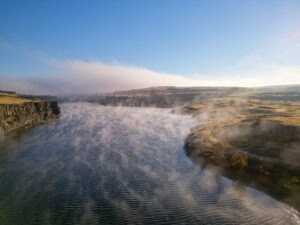
Without aerial views of the Ice Age Flood lands, we would still be debating the origins and nature of these features. Satellite and aircraft photos provide a broad overview of the channeled scablands, but in recent years, drones have given us a low-cost tool for close-up aerial photography. The detailed close-up view of the scablands showcases not only the region’s geology but also its incredible beauty. When I first saw Twin Lakes at sunrise, with the ethereal sight of fog rising from the lakes, I realized drones can help bring the scablands to the public.
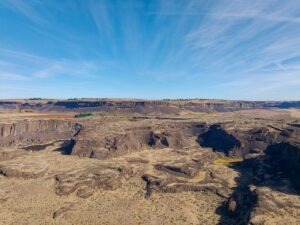
The dry cataracts at Potholes Coulee are another stunning feature not visible from the Ancient Lakes Trailhead but accessible by small aircraft. The trailhead is a popular starting point for exploring the coulee, with a rugged trail leading to the remnant cataracts that overlook the Columbia River. When the drone turned around and the dry falls came into view, I was awed by the cliffs towering over Babcock Bench. The photos tell a story of raging floods and giant waterfalls that have been silent for thousands of years.
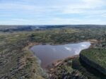
Lakeview Ranch (North of Odessa, WA) tells another story. The floodwaters flowing down Lake Creek Coulee spread out in this area, carving a random, chaotic landscape as they entered Crab Creek near Odessa. Bob’s Lakes, central to this area of chaos, are a central feature of this terrain, and the surrounding buttes and cliffs stand as a testament to the flood.
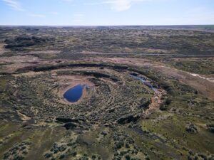
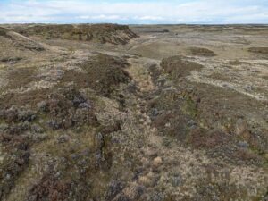
A short distance to the northeast of Lakeview Ranch (on state road 21) is an excellent collection of structures called kolks, also called potholes. These are circular depressions drilled out by vortices in the flood waters and are not obvious from the road. All of these channeled scabland features are paradoxically difficult to see from ground level!
The first time I flew a drone over Coffeepot Lake, part of the Lake Creek coulee system, the flood channels feeding into the lake became immediately obvious! Another paradox is that extremely high-altitude photos, such as those from satellites or high-altitude aircraft, make finer landscape features less obvious or even invisible. Low-flying aircraft, such as helicopters, are a possibility, but are costly to operate. Drones strike the middle ground with affordability and reasonable photographic scale. Unmanned aircraft have been flying since World War II, but with the mass production of powerful batteries, motors, and microprocessors, the aircraft’s reliability, size, and cost have become accessible to the average person.
More Details About Drones
Drones put high-quality flying cameras in the hands of geologists and others interested in geology. A drone, also known as an Unmanned Aerial Vehicle (UAV), is controlled by a pilot on the ground using a radio control system. The drone uses a high-quality camera to take images. So what can all of this fancy technology do? Many things!
Search and rescue, mapping, power line inspections, and motion pictures are common uses for UAVs. They provide access to geologic features that are inaccessible or too dangerous for direct inspection. This access is a huge win for people studying the Ice Age Floods! A drone can photograph a coulee from its bottom to the top of the canyon rim. It can also reveal ripple marks left behind by the flood waters; marks that are invisible at ground level! Using the drone as a video camera enables real-time flight down a flood channel, giving viewers a sense of the flood.
The price of these flying cameras has dropped significantly over the years. An inexpensive beginner drone with a quality camera starts at under $400. It is also under the FAA (Federal Aviation Administration) limit of 249 grams, so it doesn’t require registration. If the drone exceeds the 249-gram limit, a license fee is required, and the drone must display the registration number obtained during registration. Additionally, if you intend to use the drone for commercial work, you’ll need a UAV pilot’s license, also known as a Part 107 license. With a 107 license, a drone pilot is free to publish or donate photos as he or she wishes.
Article and images by Bill Clugston and his drones. If you want to learn more about drone photography Bill agreed you can contact him directly at bclugston1@gmail.com