|
|
|
|
|
|
|
|
|
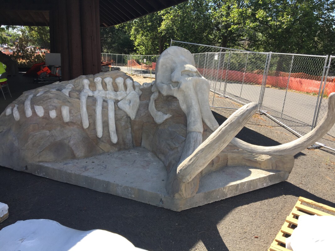
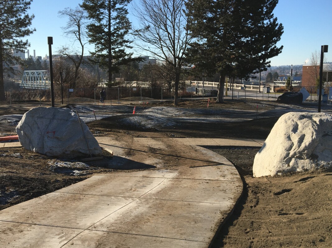
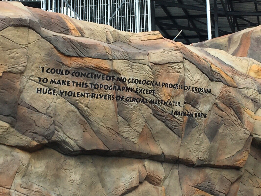
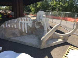
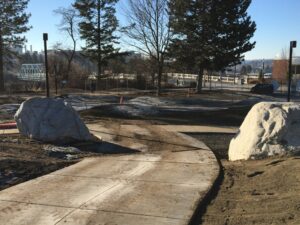
The Columbian Mammoth skeleton, sidewalks and plaza space are in place and ready for guests. The “archaeology dig” (sand box with buried artifacts) is almost ready. All geological features such as colonnades of basalt, rhythmites, and erratics are in place. The splash pad, play equipment, flood wall, and the giant “basalt column” play tower will be ready for opening day!
|
|
We are installing several bronze medals on large erratics that label each type of rock (Granite, Gneiss, and Basalt). Our IAF interpretive panels with photographs and descriptive text are being printed and installed. Each interpretive panel is specific to the events of the Ice Age Floods. There will be a parking area for 150 cars. Access to the playground will be easy for Floods Enthusiasts of all ages and abilities.
|
|
|
There’s been significant progress with the construction effort at the Ice Age Floods Playground in Riverfront Park, Spokane WA. It's now scheduled to open May 14 with a big celebration
|
|
|
|
|
We’re looking forward to the May 14 grand opening of this one-of-a-kind exciting Playground.
|
|
|
|
|
|
|
|
|
We’ve got you covered. Ice Age Floods Institute’s YouTube Channel includes a growing Playlist of Floods-related videos, including many presentations made at chapter meetings by renowned Floods experts and researchers.
|
|
|
|
|
|
|
|
Ice Age Floods National Geologic Trail
|
|
|
|
|
|
|

|
|
Justin has a BA in Philosophy from the University of Colorado, Boulder and over 23 years of previous public service most recently as the Executive Officer for Overseas Operations at the American Battle Monuments Commission (ABMC). Prior to his work with ABMC he spent 17 years with the National Park Service’s Harpers Ferry Center for Media Development as a project manager, supervisor and program coordinator for the development of visitor centers and interpretive media across the United States. While with the NPS Mr. Radford helped to create several new national park sites including Selma to Montgomery National Historic Trail and Tuskegee Airmen National Historic Site. His expertise in visitor experience development, project management and stakeholder coordination make him uniquely suited to the future needs of Ice Age Floods National Geologic Trail.
|
|
The National Park Service has selected Justin Radford as the Ice Age Floods National Geologic Trail’s new Program Manager, the Trail’s first permanent full-time staff member. Mr. Radford follows in the footsteps of many who have worked tirelessly to bring Ice Age Flood National Geologic Trail into existence. He will be duty stationed in Coulee Dam, Washington and will also join the Management Team of Lake Roosevelt NRA.
|
"Traveling the region is an experience of geologic power and grace. It is an honor to be selected to help ensure all our visitors have a chance to connect with the special places along Ice Age Floods National Geologic Trail,” said Mr. Radford. " I am looking forward to working with our partners to help every visitor be as excited about the Trail as I am.”
|
“Justin brings a wealth of experience in planning and developing visitor services to Ice Age Floods National Geologic Trail,” said Superintendent Dan Foster. “His depth of experience, along with a dedication to providing quality visitor opportunities, make him a great fit for this position.”
|
|
Ice Age Floods Institute is thrilled to have such a talented and dynamic leader of the Ice Age Floods National Geologic Trail as a partner in sharing the story of the incredible Ice Age Floods.
|
|
|
|
|
|
|
|
|
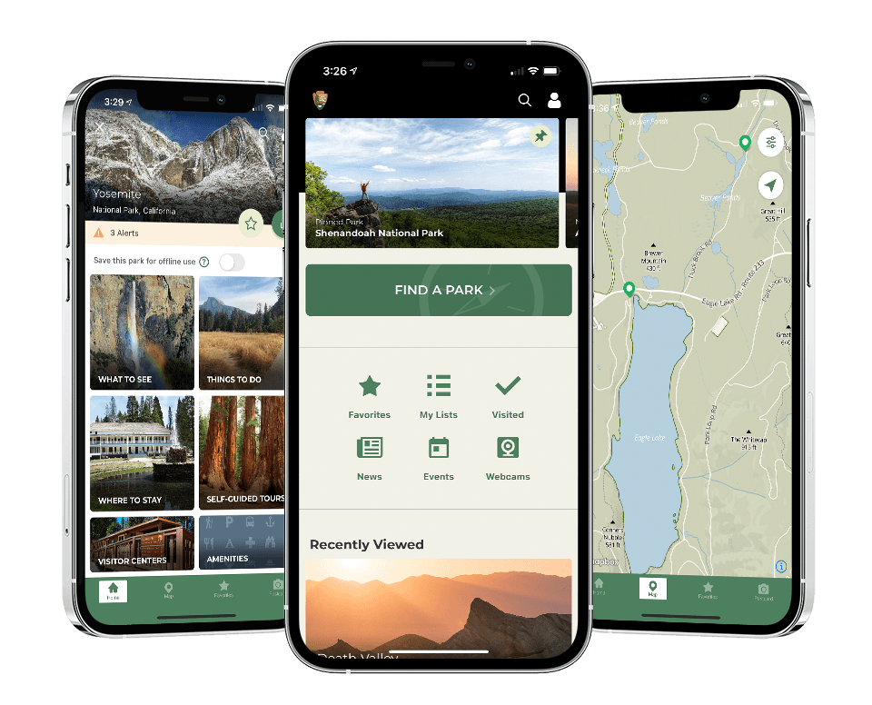
- The NPS App connects visitors to all 420+ national parks from one single app.
- The new NPS App will help visitors learn about trails, visitor centers, campgrounds, directions, fees and passes, weather alerts, passport stamp locations and more.
- With over 420 national parks across the country and in every state, use the NPS App to plan your next adventure.
- Millions of visitors journey to national parks each year, and the NPS App provides users with an engaging and informative platform to learn about national parks, plan their visits, and have a great in-park experiences.
- Use the app to connect to your nearby national parks and recreate responsibly.
- To download the National Park Service App search “National Park Service” from the iOS App Store or Google Play to connect to your national parks from your smartphone.
- Connect with national parks from wherever you are using the easy-to-use NPS App.
- The app has received a positive response since the soft launch in February, as many users have found it to be a great resource for accurate and up-to-date park information.
Your companion for National Park Week
|
- Before you head out on your National Park Week adventure, download the new NPS App.
- #NationalParkWeek is an annual celebration for people to discover and enjoy our country’s remarkable network of natural, cultural, and recreational sites. Use the #NPSApp to connect with national parks across the country.
- April 17: Park Rx Day & Fee-Free Day - The first day of National Park Week, April 17, is a fee-free day – if you’re visiting national parks today, check out the NPS App to find things to do, download maps, and discover more ways to experience national parks.!
- Find places of healing and calm in national parks on #ParkRXDay using the #NPSApp.
|
Let a park ranger be your guide!
|
On April 16th the National Park Service is releasing a brand new official app for all 420+ national parks. Find interactive maps, tours of park places, on-the-ground accessibility information, and more. The app was created by National Park Service staff—people who know national parks—to help you make the most of your visit. With all of these parks and a brand new app, it will take some time to finish creating content for each park. If you don’t find what you’re looking for now, check back regularly as our rangers work to complete the experience for each of our parks.
|
Unlike other apps, NPS Mobile takes authoritative information from park rangers and combines it with a great suite of features, including interactive maps, saved data for offline use, accessibility, self-guided tours, things to do, shareable digital postcards, passport stamp locations, hours and locations for points of interest, and more.
|
Benefits of the app (discover more on your visit)
|
- The NPS App gives its users up-to-date information about every national park from one, easy-to-use app. Plan your adventure from your phone, download maps and tours ahead of time, and find things to do and places to visit on your adventure.
- The app is fully accessible and aims to be a guide for all visitors to national parks.
- Your trip begins at home. Use the NPS App to plan your trip and download maps and directions ahead of time.
- Using the NPS App, visitors can build personalized lists and save and share information with friends relevant to their interests and upcoming trips.
- No internet access? No problem! You can download content for offline use. It’s especially handy if you’re exploring remote areas in parks or concerned about data limits.
- Have a question while you’re planning your trip, or need to know where the visitor center is? The app provides an easy way to contact parks directly.
- While you’re in the park, use the self-guided tours to learn about the park, create and share a virtual postcard, and stay informed of alerts and closures.
- This app is available offline, so users can download resources before their visit, which is especially important for visitors hoping to visit parks in more remote locations that may not have internet access in all areas of the park.
|
|
|
|
Time in nature promotes overall health and wellness benefits. A visit to a national park can boost physical, mental, social, and psychological health.
|
|
|
|
|
|
|
|
|
|
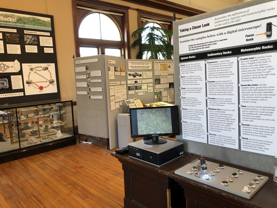
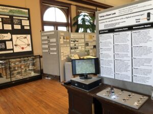
In addition to information about the ice age floods, this exhibit highlights the geology of the region, including how it was formed, a collection of minerals and precious metals, and samples and even cores taken from various nearby mines. A microscope connected to a display screen, a light up display case of crystals, and super enlarged photographs of rocks allow close inspection.
|
|
Visitors can create their own topographic map illustrations using the same tools as early geologists such as a 1922 guide on map making and a stereoscope. J.T. Pardee’s ground breaking paper presented in 1942 on “unusual currents” and some of his drawings can be examined.
|
|
|
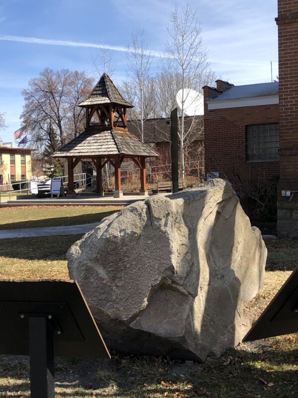
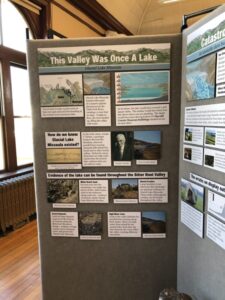
The display at the Ravalli County Museum on Glacial Lake Missoula and geologic features of interest in the Bitterroot Valley in Montana is nearly complete and will be officially opened to the public by late spring. An outdoor kiosk on Glacial Lake Missoula with several large signs centered around a large erratic relocated from a local ranch has been in place since last October.
|
|
Glacial Lake Missoula covered the City of Hamilton, Montana, to a depth of more than 250 feet and extended as far south along the Bitterroot River as present Lake Como. The lake created numerous local landscape features which are apparent when you know what to look for and where to look. Photos taken by nationally known commercial photographer Ernst Peterson, who died in 1991, have been restored and are on display.
|
|
|
This interior display may be only temporary, as some of the materials are on loan and other topics are being planned. It is expected to last at least until the fall. Anyone interested in this unique collection of information about the area is urged to make a visit before long and can even view it right now at certain times.
|
|
|
|
|
|
|
|
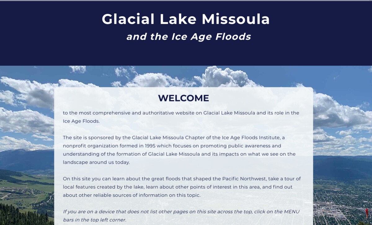
The website first created in 2002 by the Montana Natural History Center for the Glacial Lake Missoula Chapter has been resurrected with additional photos and revised text. The replacement can be found at the original website address: GlacialLakeMissoula.org
|
|
For the last decade or so the old site was not only out of date but could not be accessed to make additions or corrections. Many others have created sites in the meantime, each with its own approach to the story of the role of ancient Lake Missoula and its relation to the ice age floods, some more complete and accurate than others. Finally, with the technical wizardry of the staff at the Montana Natural History Center and the skills and advice of Kara Shapiro of Corvid Studio, a local website design consultant, a replacement has emerged utilizing the original address.
|
|
|
|
This site is not meant to replace the others, but to draw together many resources that exist as a base for further exploration. It is intended to inform those completely new to Glacial Lake Missoula or the Ice Age Floods as well as those with interest in additional local details. The objective was to keep the site relatively short and simple. Except for the overview, the information that can be found on other sites is not repeated but is linked for easy reference. Others are invited to link to our site as well.
|
|
|
|
|
Although at this time there is the ability to update the site, information about current events and field trips is left to the Glacial Lake Missoula Chapter Facebook page, or the calendar and events posted on the Ice Age Floods Institute site or newsletter.
|
|
|
|
|
|
|
|
Do you have a geology question? We might have an answer!
Do you have a geologic fact to share? We have a way to do that!
|
|
|
|
|
|
|
|
Explore several interesting geologic and floods features in 6 self-guided field trips prepared by Steven Reidel and George Last for classes at Washington State University.
|
|
|
|
|
|
|
|
|
An interesting article about the cosmic dangers to life that many may not be aware of:
|
|
|
|
|
|
|
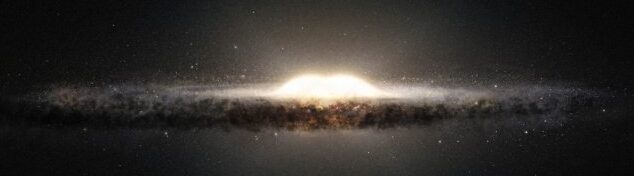
More and more, it seems that the existence and persistence of life on Earth is the result of sheer luck. According to a new analysis of the history of the Milky Way, the best time and place for the emergence of life isn't here, or now, but over 6 billion years ago on the galaxy's outskirts.
|
|
|
|
That specific location in space and time would have afforded a habitable world the best protection against the gamma-ray bursts and supernovae that blasted space with deadly radiation.
|
|
|
As of about 4 billion years ago, the central regions of the galaxy (which include the Solar System) became safer than the outskirts - safe enough for life to emerge, if not quite as safe as the outskirts had been.
|
|
|
|
|
|
|
|
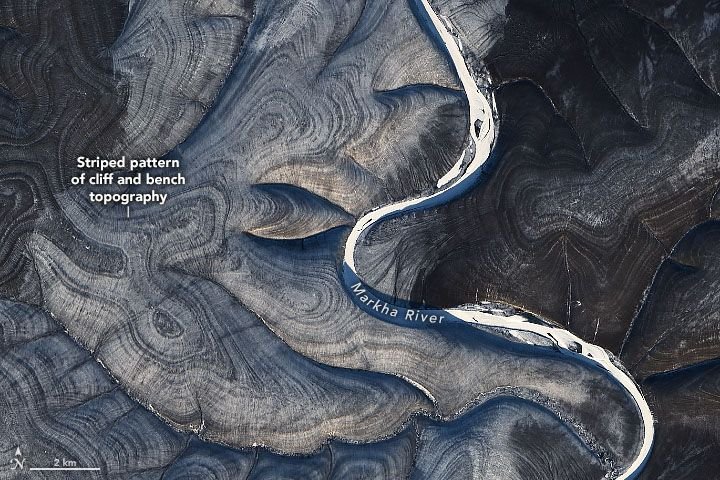
Near the Markha River in Arctic Siberia, the earth ripples in ways that scientists don't fully understand.
|
|
Earlier this week, NASA researchers posted a series of satellite images of the peculiar wrinkled landscape to the agency's Earth Observatory website. Taken with the Landsat 8 satellite over several years, the photos show the land on both sides of the Markha River rippling with alternating dark and light stripes.
|
|
|
|
The puzzling effect is visible in all four seasons, but it is most pronounced in winter, when white snow makes the contrasting pattern even more stark.
|
|
|
|
|
|
|
|
|
Members who want to do a short article, or describe a field trip location of interest, or describe some geologic problem or site, can use our online form to submit a question or write-up to our technical committee for an answer or review before we post it on our Geology Corner page.
|
|
|
|
Upcoming Calendar Events
|
|
|
|
|
THANK YOU IAFI MEMBER SUPPORTERS
|
Every member at every membership level is vital to IAFI’s continued success. Your support helps us meet our mission of providing the Ice Age Floods story to the public and continuing our work on the Ice Age Floods National Geologic Trail. Every gift counts, no matter the size. Thank you for making the IAFI what it is today and for helping shape it for the future.
|
|
|
|
|
|
Ice Age Floods Institute (IAFI) is a 501(c)(3) tax-exempt, non-profit educational organization (EIN 91-1658221), founded in 1995 and recognized as an official authority on the Ice Age Floods, providing accurate, scientific-based advice to members and the public. We were instrumental in 2009 Federal legislation authorizing National Park Service designation of the
Ice Age Floods National Geologic Trail (IAFNGT).
|
|
|
|
|
|
|