
White Bluffs
![]() White Bluffs – Hanford Reach National Monument – Rhythmites and Overlook
White Bluffs – Hanford Reach National Monument – Rhythmites and Overlook
Best Observation Points By Automobile
Follow an unpaved road off State Route (SR) 24, approximately 17 highway miles southwest of Othello, Washington or 53 miles north Richland. At milepost (MP) 63 turn south on the unpaved road and pass through a gated entrance to the Wahluke Unit of the Hanford Reach National Monument. Drive 8 miles to the White Bluffs Overlook, located at N 46.631787°; W 119.396108° (#47 in Figure 1).
Warning: This is a day use area only. The gated entrance automatically closes and remains closed between two hours after sunset and two hours before sunrise.
White Bluffs Rhythmites Trail: From the former White Bluffs Ferry Landing climb onto the White Bluffs with spectacular overviews of the Columbia River, landslides, recent tall sand dunes and a rhythmite-filled paleochannel (#48 in Figure 1).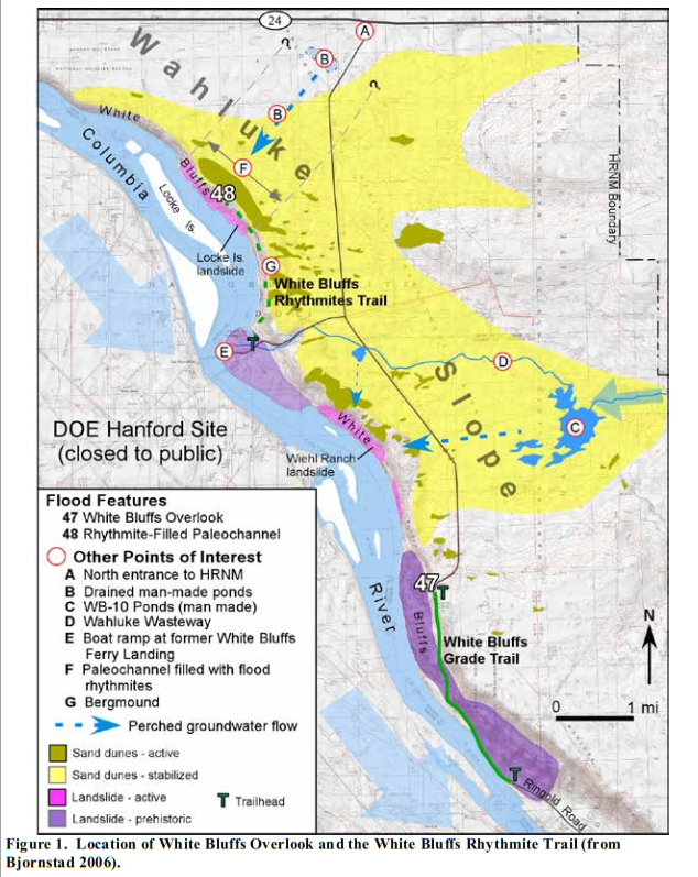 Trailhead Location: N 46.67713°; W 119.44462° (Figure 1). Take the route described above, but after entering the Wahluke Unit of the Hanford Reach National Monument, drive 4 miles then turn right toward the old White Bluffs Ferry Landing (unmarked). After descending the grade, at 1.2 miles from the intersection, park next to a large grove of trees in the flat area to the right at the base of the bluff.
Warnings: The trail follows the margin of some steep, unstable slopes. Beware of steep cliffs and dropoffs, which can be unstable and prone to slumping. Avoid walking immediately above or below any of the steep unstable slopes. There is no shade or potable water along the trail.
Trail Length / Difficulty: 1.7 to 3.0 miles one-way / Moderate
 Trail Description: Follow a single-track trail to the northeast toward the bluffs. After 0.2 miles the trail begins its diagonal ascent up the bluffs. At 0.5 miles from the trailhead, you will arrive at the top of the White Bluffs escarpment where the trail levels off onto a bench that marks the contact between the red-brown Pliocene-age Ringold Formation and the grey slackwater flood deposits located above and to the right.
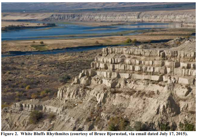
You can see up to 15 regularly spaced, banded slackwater flood rhythmites ahead in the distance, which fill a paleochannel carved into the Ringold Formation (Figure 2). Underfoot, on the other hand, only a few thin rhythmites are present here at the margin of the paleochannel. Most rhythmites are covered with a thick pile of younger windblown sand.
As you go northward, the rhythmites will become more obvious. Lots of ice-rafted erratics are visible at or above the contact between the Ringold Formation (below) and the rhythmites (above). The Ringold Formation here consists of only fine-grained clay, silt and sand. Any gravel you see here must have rafted in on icebergs during Ice Age flooding at the same time the rhythmites were forming.
At approximately 1.1 miles from the trailhead, notice the domed pile of gravel above the trail to the right, near the lip of the bluffs (at N 46.69183; W 199.44145). This is a bergmound that formed when an iceberg became grounded against the edge of the bluffs. After the ice melted, it left behind this pile of multisized, foreign rocks, which came from hundreds of miles away either north or east of the Columbia Plateau.
The thickness and number of rhythmites increases as you approach the axis of the paleochannel, which trends perpendicular to the bluff face. Continue on another 0.6 miles (1.7 miles from the trailhead) and you will arrive at an area of tall active sand-dune development. These dunes are forming from strong winds that blow the loosened sediments up from the Locke Island landslide below.
Carefully continue north along the top of the bluffs for better views of the rhythmites up close, or turn around and retrace your steps back to the trailhead.
Material taken in large part from On the Trail of the Ice Age Floods: A geological field guide to the Mid-Columbia, by Bruce Bjornstad, 2006, Keokee Books, Sandpoint, Idaho.